
A Kimolos boat trip leaves the island of Milos for its small neighbour. The neighbour lies to the north-east, just across a narrow strait. It is a quiet island of bays, sea caves and soft volcanic rock. Secluded beaches on its north side suit sea craft.
Boats cross from Pollonia and Adamas, the two ports of Milos. Only a short stretch of open sea lies between the two islands. A Kimolos boat trip then follows the coast and stops for swimming. Other trips go straight to the small island harbour of Psathi.
What is a Kimolos boat trip from Milos?
A Kimolos boat trip is a sea outing from Milos to the small island across the strait. The boat passes bays, sea caves and pale volcanic cliffs. It stops for a swim or lands at the port. The island has one village, Chorio.
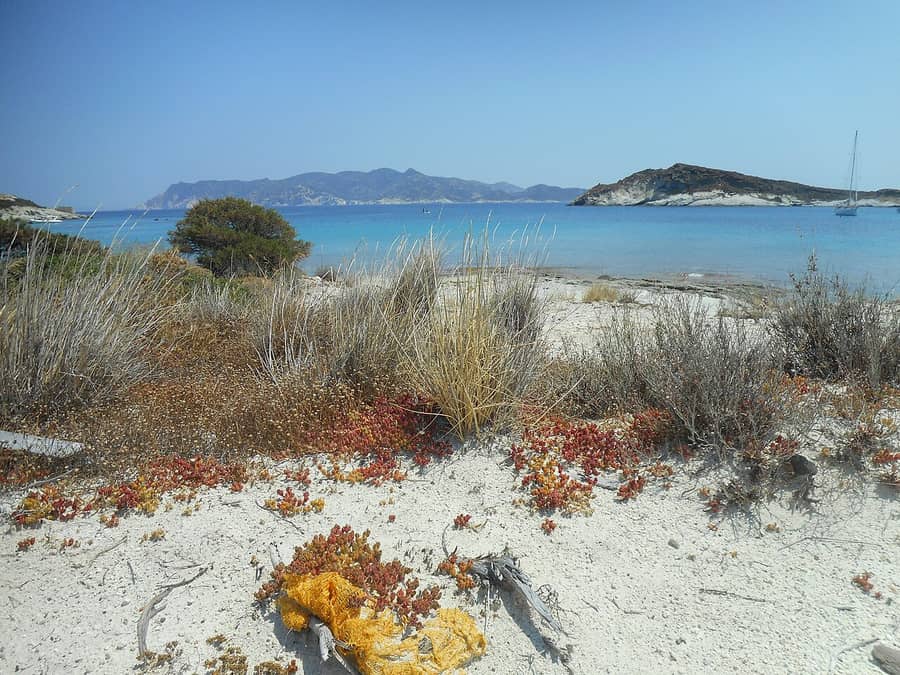
Kimolos covers 36 square kilometres, so the island is small. Its coast runs for 38 kilometres. The shoreline bends into bays and is dotted with small islets. A Kimolos boat trip follows this long edge from the water.
The beaches are clean and largely sheltered from the wind. Sand lies in one cove and pebbles in the next. Thrift and lentisk bushes give shade, and certain coves have rocks for diving. The water is shallow in places and deep in others.
The land behind the shore is quiet. Kimolos has one true village, Chorio, on a hill in the south-east. A medieval castle forms its old core. The harbour village of Psathi lies 800 metres away, and the boats land there.
The smaller settlements, such as Goupa, Prasa, Aliki and Dekas, fill up mainly in summer. In winter only a handful of them keep residents. About 600 people stay through the cold months. The majority of them live in Chorio.
The rock is the other draw. Kimolos belongs to the same volcanic arc as Milos, and pale tuff covers wide areas. Tuff is a light stone that is easy to cut. On a Kimolos boat trip, the pale cliffs show first on approach. Wind-blown dust has carved a mushroom-shaped rock, called Skiadi, inland.
- Coves: Sheltered bays with sand or pebbles line the shore.
- Caves: Sea caves open along the coast.
- Springs: Warm spring water flows into the sea at the edge of certain bays.
- Tuff: Pale volcanic stone covers wide areas of the island.
- Harbour: Psathi is the port where the boats land.
A Kimolos boat trip joins three sights. You see the coast from the water, the village from the port and the odd rocks inland. The island is small, so local transport covers the rest. A bus and a taxi run to the popular beaches.

How does a Kimolos boat trip cross from Milos?
A Kimolos boat trip crosses the strait between Milos and Kimolos. It starts from Pollonia or Adamas. The gap is short, only 900 metres at its closest point. The boat then lands at Psathi, the harbour of Kimolos, or cruises along the coast.
Every Kimolos boat trip from Milos starts at one of two ports. Adamas is the principal harbour and the biggest tourist hub of the island. The town lies on the north-eastern side of the bay. The fishing village of Pollonia is the second port.
Pollonia hugs a small inlet at the far north-eastern corner of Milos. That corner looks towards Kimolos. A small boat connects the village to its neighbour island on a regular basis. Adamas lies almost 10 kilometres from Pollonia.
The crossing on a Kimolos boat trip is short. At the closest point, only 900 metres of water separate the two coasts. This narrow band of sea is called the Ammoni strait. On the far shore, the link ends at Psathi, the harbour of Kimolos.
Different kinds of vessel make the crossing. One is an open-type ferry, a boat with an open deck. Another is a traditional trawler, a working fishing boat. The third is a speedboat taxi, a fast boat that carries passengers.
A local ferry is a transport link, while a Kimolos boat trip is a sightseeing outing. The ferry joins the two ports. A trawler or a sea taxi can sail round the coast instead, to bays that face north. Those bays lie open to the north wind, so visits wait for good weather.
- Adamas: The principal harbour, found on the north-eastern side of the bay.
- Pollonia: The smaller harbour, found on the tip nearest to Kimolos.
- Psathi: The harbour of Kimolos, where the crossing ends.
- Local ferry: A plain link between the ports of the two islands.
- Home base: Excursion boats, sea taxis and boat rentals on Kimolos itself are based at Psathi.
The crossing is the short part of a Kimolos boat trip. The two Milos ports, the narrow strait and the harbour at Psathi frame the route. What follows depends on the vessel and the wind. The north coast lies open to the north wind. Beaches in the lee stay calm.
Which beaches can a Kimolos boat trip reach?
A Kimolos boat trip can reach the secluded northern beaches, a sea cave and a hot-spring shore. The south-west coast adds Aliki, Bonatsa and Kalamitsi. The weather sets each stop, because the northern coves are open to the north wind.
On a Kimolos boat trip, the coast stretches for about 40 km around the island. Beaches of sand, pebbles, shallow water and deep water follow one another, with rocks to dive from. They share one trait: the water is clean and clear blue.
A trip around the island passes the south-west coast, where bushes line the shore. There, Aliki, Bonatsa and Kalamitsi lie close together, and only Psathi draws more visitors. Aliki mixes pebbles and sand, Bonatsa is sandy, and Kalamitsi is a double beach of both.
Kalamitsi has a small harbour for caiques, the local boats that link the island with Milos. A figure carved into the rock there is the work of an unknown artist. At Aliki, a lake by the beach hosts migrating birds in spring.
The northern part of the island has secluded beaches that a sea craft can explore. A Kimolos boat trip goes round the island by traditional trawler or speedboat taxi. The names to know are Gerakia, Agioklima, Therma, Mersinia and Zefokalamo, but almost any bay invites a swim.
Gerakia is a sea cave, not a beach, at the Gerakia headland. On a Kimolos boat trip, swimmers dive into turquoise water and wade through the shallow cave. At Agioklima, a hot spring flows out right at the water’s edge.
- Aliki: Pebbles and sand, with a lake that draws migrating birds in spring.
- Bonatsa: Sand, next to Aliki, with a canteen on the shore.
- Kalamitsi: Pebbles and sand, beside a small harbour for caiques.
- Monastiria: Open to the north wind, with Soufi, a sheltered beach, a walk away.
- Agioklima: A hot spring flows out at the water’s edge.
A Kimolos boat trip mixes pebble beaches, sandy beaches, a sea cave and a hot spring. The northern coves are open to the north wind, so the weather sets the route. Rema, Karas and Klima, on the east and north shore, add three more places to swim.

Why are the sand and sea so pale at Prassa on a Kimolos boat trip?
A Kimolos boat trip to Prassa shows a short white beach and blue-green water. The sand is white because of kimolia, the white rock that gave the island its name. Under the surface, the sand is just as white as on the shore.
A Kimolos boat trip reaches Prassa, also written Prasa. It is a seaside settlement on the east side of Kimolos, about 5 km north-east of Chorio. Locals call its beach the white beach, and it measures only about 200 m.
The island gave its name to kimolia, a white rock known as chalk. The sand at Prassa takes its white colour from this rock. It is thick sand, and the white carries on under the water.
On a Kimolos boat trip, the sea over the white sand looks blue-green and turquoise. Hills of bentonite, a type of clay, frame the small beach. Old mines for perlite, a volcanic rock, sit above it, and tamarisk trees grow at its edge.
Across from the settlement lies Prasonisi, a small islet that has no permanent residents. At the cape of Agios Georgios, sea caves give shelter to the Mediterranean monk seal. The view from that cape takes in the caves.
Baths stand at the entrance of the settlement, and Prassa has a canteen on the beach. A short distance further on lies ground that was once mined for bentonite. Younger residents of the island work mainly in the quarries of Prassa and nearby Milos.
- Sand: White and thick, on the shore and in the water.
- Water: Turquoise and blue-green.
- Hills: Bentonite hills, with old perlite mines above.
- Islet: Prasonisi lies opposite and has no permanent residents.
- Caves: Sea caves at Agios Georgios shelter the monk seal.
Prassa packs white sand, blue-green water, bentonite hills and seal caves into one short stretch of coast. A Kimolos boat trip lets swimmers see the whole scene from the water. The beach itself is small, and the islet of Prasonisi sits across from it.
What lies under the water at Ellinika on a Kimolos boat trip?
A Kimolos boat trip to Ellinika reaches the west side of the island. There, an ancient city lies sunk in shallow water. Graves from the Mycenaean era to the Hellenistic era lie along the beach. The islet of Agios Andreas faces the shore.
Ellinika is a beach on the west side of Kimolos, close to Dekas and Mavrospilia. The island’s ancient city lies sunk in the shallow water there. Ruins of houses and tombs also lie on the seabed of this area.
The islet of Agios Andreas stands 200 metres from the island, opposite Dekas, Ellinika and Mavrospilia. Islanders call it Ai-Ntria, and the acropolis, or high fort, of the ancient city stood on it. On a Kimolos boat trip, the islet and the beach come into view together.
The islet was still home to people in early Christian times. An earthquake in the 1st century left it empty. The city on the shore is thought to have been home to the Kimolians until its end.
Finds from the Mycenaean, Geometric, Archaic, Classical and Hellenistic periods show that people lived at Ellinika. In ancient times Kimolos had two fine harbours, and their remains lie at Ellinika. The wide cemetery spreads over the beach and the land around it.
Aspragremna, in the same area, suits photographs and gives a fine sunset. Careful eyes can spot fossils of sea creatures there. The land route is a dirt road, and notes on getting around Kimolos cover it.
- City: Remains of the island’s ancient city lie in the shallow water.
- Tombs: Graves from Mycenaean to Hellenistic times lie on the beach.
- Islet: Agios Andreas lies 200 metres offshore and has no residents.
- Harbours: The remains of two ancient harbours lie at Ellinika.
- Aspragremna: Sea fossils and a sunset view mark this nearby spot.
A Kimolos boat trip to Ellinika shows an old city that the sea now covers in part. The ruins on the seabed, the tombs on the beach and the islet belong to one story. Dekas and Mavrospilia lie beside it, so a Kimolos boat trip here takes in all three.
What does a Kimolos boat trip show at Goupa and its boathouses?
A Kimolos boat trip suits a stop at Goupa, a small fishing settlement by the sea. Boats rest there in rooms cut into soft rock, called sirmata. Wooden doors in bright colours close the opening of every boat room in the rock.
Goupa lies at the southern exit of Chorio, the only town on Kimolos. The settlement is small. People live in it mainly in summer. In winter very little population remains, as in the other small settlements on the coast.
Sirmata are caves carved into the soft rock. Islanders keep their boats inside them through the winter. A Kimolos boat trip crosses the same sea. These boat rooms show why boats matter on this coast.
Wooden doors in bright colours close the caves. Each cave and door pair forms one boat room. On a Kimolos boat trip, Goupa shows a boat stored in rock instead of in a shed. The word is also spelled syrmata.
Rema lies right next to Goupa. It is a natural swimming pool framed by rocks, the small islets called Rematonisia, and more sirmata. The bay lies on a lee shore, meaning the side away from the wind. Swimmers of every age use it.
Karas follows after Goupa and suits dives. Sea skills run deep in the history of the island. Kimolians gained great experience at sea in the old days. The French and the Sultan both valued it.
- Place: Goupa sits at the southern exit of Chorio.
- Boat rooms: Sirmata are caves that hold boats in winter.
- Doors: Wooden doors in bright colours close the openings.
- Next bay: Rema, a natural swimming pool, lies beside Goupa.
- Next stop: Karas follows Goupa and suits dives.
A Kimolos boat trip supplies the crossing, and Goupa supplies the story of the boats ashore. The sirmata show where boats rest. Rema and Karas show where swimmers and divers enter the water. All three sit close together on one stretch of coast.

How does a Kimolos boat trip land at Psathi, Chorio and the castle?
A Kimolos boat trip lands at Psathi, the port of the island. The hill village of Chorio stands 800 metres away. Chorio is the only town. Its medieval castle is the old core, and house walls served as its defences.
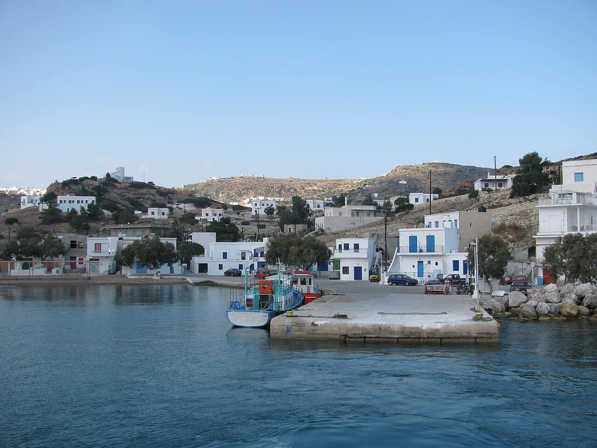
Psathi is the main port of Kimolos. A Kimolos boat trip meets a small settlement there, with a small beach near the harbour. White houses, narrow stone-paved lanes, small boathouses and flowered courtyards fill the waterfront. Hotels, rooms, cafes and tavernas stand there too.
Slipways for hauling boats out of the sea are cut into the rock at the harbour. The islanders call them sirmata or magazia. Paddlers see this waterfront from the sea on the kayak route to Kimolos. That route starts at the small beach of Psathi.
Chorio rises on the foothills of Xaplovouni. A road links it to Psathi, 800 metres away. A Kimolos boat trip therefore needs no long transfer to reach the village. Kimolos has had only one town since ancient times, and islanders say Chorio, not Chora.
On a Kimolos boat trip, the castle marks the older part of Chorio. It is a medieval castle, square in shape, from the 14th or 16th century. It has two rings of houses, one inside the other. The outer ring formed the defensive wall, and the inner ring lies in ruins.
The outer ring has two gates: the lower gate faces south on the market road. The upper gate faces east beside the folklore and maritime museum. The gates bear the dates 1646 and 1650. They mark repairs after pirates burned the castle in 1638.
- Houses: The castle held 123 two-storey houses.
- Ring road: A lane between the two rows of houses fitted only small carts.
- Square: The church of the Birth of Christ stands by a small square.
- Museum: The archaeological museum faces the church of Odigitria.
- Age rule: As a rule, a house nearer the castle is older.
A Kimolos boat trip therefore ends one stage at the harbour and starts another on foot. Psathi gives the harbour and Chorio gives the hill village. The castle adds the oldest layer of the town. Each place sits close to the next, so the landing is easy to follow.
How can visitors on a Kimolos boat trip reach Skiadi on foot?
A Kimolos boat trip brings visitors ashore at the harbour, and Skiadi lies inland. The final part of the way is a walk on foot. A circular road starts and ends at Chorio. A signed footpath then leads to the mushroom-shaped rock.
Skiadi is a huge rock shaped like a mushroom. Skiadi sits on the north-west side of Kimolos, just west of a height named Sklavos. The rock sits in the middle of a bare plateau. It is the trademark of the island.
Wind built the shape. Dust and grains of sand scrape the rock, and its soft base wears away faster. The base grows narrower, while the harder top stays almost whole. The process has a name: ablation.
The rock is a natural monument. It is listed in an atlas of the geological monuments of the Aegean. The plateau gives wide views over the south-west and west coasts, including Ellinika, Mavrospilia and Athinia. The views also reach a large part of Milos.
A circular road starts and ends at Chorio. The car route passes Lebounia, Xevri and two churches of Profitis Ilias, outer and inner. A second way goes by Agios Minas, the only asphalt part of the circle. It meets the same path.
Between the two churches, the car stops, and a path marked with arrows continues on foot. Walkers from a Kimolos boat trip can also cover the whole distance on foot. In summer they carry water, a cap and sun lotion.
- Position: Skiadi stands in the north-west on a bare plateau.
- Cause: Wind and sand wore the soft base.
- Start: A Kimolos boat trip lands at the harbour, and the walk starts from Chorio.
- Cistern: A cistern stands at Xemvri, before the church of Agioi Anargiroi.
- Dress: Long trousers and shoes for long walks suit the path.
A Kimolos boat trip covers the sea part of the day. The road and path to Skiadi cover the land part. The rock is a lesson in wind erosion, and the plateau gives a long view. The circular road from Chorio keeps the route simple.
Can a Kimolos boat trip pair a village landing with swims at Polyaigos?
A Kimolos boat trip can pair a landing on Kimolos with swims at empty Polyaigos next door. The boat calls at the port, so passengers can see the village. It then moves on to the bays, where the day turns to swimming.
Kimolos and Polyaigos belong together on the map. Both islands share one municipality, meaning one local council area, and its seat is on Kimolos. Nobody lives on Polyaigos, so the inhabited island is the natural start. A Kimolos boat trip therefore begins among houses and ends among bare hills.
Boats arrive at Psathi, the harbour of Kimolos. The main village is Chorio. Together they make the land half of the plan. A bus covers the route between the village, the port and the beaches. Taxis also run on the island.
Walkers do best when the landing comes early. Local advice for summer is to walk before the hottest part of the day and swim after it. A Kimolos boat trip that lands first and swims later follows that advice without extra effort.
The reverse order works as well. A boat can swim first at Polyaigos and land at Psathi at the end. Cafes and food stops also wait at Psathi, so the day can close at the waterfront.
Local boats make the pairing easy. Speedboat taxis and traditional fishing boats sail round Kimolos to its quiet northern beaches. The same boats cross to Polyaigos. The sea half of a Kimolos boat trip can therefore use either shore, or both.
Of all the empty islands in the Aegean, Polyaigos is the largest, and goats keep its slopes bare. Its beaches face mainly south, and sea caves along the coast shelter monk seals. The bays, caves and wildlife of the island are covered in detail for a Polyaigos boat trip.
- Port: Boats tie up at Psathi, where small boat houses line the shore.
- Village: Chorio, the main village, sits on a hill in the south-east.
- Paths: Every marked walk on Kimolos starts in Chorio.
- Boats: Speedboat taxis and fishing boats cross from Kimolos to Polyaigos.
- Caves: Sea caves on Polyaigos give Mediterranean monk seals a refuge.
A Kimolos boat trip that pairs both islands keeps the day easy to follow. Kimolos supplies the port, the village and the paths. Polyaigos supplies the empty coast and the swims. A route that names the landing and the swim stops shows which half is which.

What do travellers bring on a Kimolos boat trip?
A Kimolos boat trip calls for a short, simple packing list. Water, a hat, sun cream and swimwear cover the sea. Sturdy walking shoes cover the village paths, and a light layer covers the crossing. A little cash covers small shops.
On a Kimolos boat trip, cash is useful on land. Chorio has bakeries, mini markets, cafés and general stores, and the shops are small. Canteens serve the beaches of Bonatsa and Prassa. Cash machines stand in Chorio and at Psathi, but a little cash saves a trip.
Walking shoes matter when the plan includes the village. The paths from Chorio are stony and rough in places. Shoes that cover the whole foot work better than sandals. The route to Skiadi is easy, and the stretch beyond it is medium.
Heat from the sun is the main thing to plan for. A hat and sun cream suit the deck, the village lanes and the bare slopes of Polyaigos. Goats keep that island barren, so shade is scarce there. Apply cream before boarding and top it up after every swim.
Water needs its own space in the bag. Local advice for walkers is to carry plenty of water and something to eat. Nobody lives on Polyaigos, so a Kimolos boat trip to its bays reaches a shore with no shop. A full bottle before boarding covers the swim stops.
Swimwear can go on under the clothes from the start. Every walking route on Kimolos ends at a beach. A light layer helps on the crossing of a Kimolos boat trip. A thin top with long sleeves is enough, since open decks feel windier than the shore.
- Cash: Notes and coins suit small shops and beach canteens.
- Shoes: Solid shoes with full cover suit the stony village paths.
- Sun: A hat and sun cream protect against the strong summer sun.
- Swimwear: Wear it early, because the walks all end at beaches.
- Layer: A thin top blocks the wind during the crossing.
A Kimolos boat trip needs a light bag with a clear plan behind it. Cash, solid shoes, a hat, sun cream, swimwear, water and a thin layer cover the whole day. Each item has one job, from the crossing to the village paths to the swim stops.
How does a traveler choose and plan a Kimolos boat trip?
A Kimolos boat trip comes in three forms. These are a shared cruise, a private boat and the local ferry plus a walk. Travelers compare the boat type, the start harbour, the length of the day and the landing plan.
A shared cruise carries a mixed group on a set route. The stops are fixed in advance. It suits travelers who want a simple day without planning. A private boat belongs to one group, which agrees the route with the skipper. A private Kimolos boat trip can follow the wishes of the day.
The local ferry is the third way. Open ferries, traditional trawlers and a speedboat taxi link Milos and Kimolos every day. Only a narrow channel divides the two islands, so the crossing is short. The ferry gives no coastal route, but it gives time on land for a walk.
A half day suits one stretch of coast and a swim stop. A full day adds a landing and a longer route. The start harbour matters. Pollonia is the north port of Milos, and the local ferry leaves from it. Kimolos lies to the north-east, so a start there keeps the sea leg short.
A good description of a Kimolos boat trip states how the boat reaches the shore. It names the landing point, such as the port at Psathi or a bay. It says whether time on land is part of the plan. It also says what changes when the north wind blows.
- Boat: A trawler, a speedboat and an open ferry each give a different ride.
- Start: The Milos harbour of departure sets the length of the sea leg.
- Landing: The plan names the quay at Psathi or a swim stop in a bay.
- Time ashore: The plan says whether a walk to Chorio is part of the day.
- Wind plan: The operator names a calmer coast for days with a north wind.
With these checks done, the choice becomes clear and the day fits the stay. Visitors who like longer days under sail can read about a Milos sailing tour. Visitors planning a whole holiday can also look at the wider list of activities in Milos.
Which questions come up before a Kimolos boat trip?
A Kimolos boat trip raises eight common questions. They cover nights ashore, children, swimming, wind, food, shops, mobility and the season. The answers below are short and use plain words. Each one is about the island, not about a single boat.
Can visitors stay overnight after a Kimolos boat trip?
Yes, the island has hotels, rooms to let and apartments. They stand in Chorio, Psathi, Aliki, Kalamitsi, Bonatsa and Prasa. A night ashore leaves time for the village and its beaches without a return crossing the same day. A ship links Kimolos with Piraeus all year, and Milos is linked by ferry every day.
Is a Kimolos boat trip suitable for children?
Yes, when the sea is calm and the stops are easy. Rema is a sheltered shore that suits all ages. Aliki, Bonatsa and Kalamitsi have shallow water, which keeps paddling easy. Chorio also has a children’s playground at Kambos, one of its small squares. Parents ask the crew for life jackets in children’s sizes.
Can non-swimmers enjoy a Kimolos boat trip?
Yes, because much of the day happens on deck. Non-swimmers stay on deck, watch the coast and wear a life jacket near the water. At Gerakia Cave, the shallow water lets visitors walk through the cave on foot. The island has shallow beaches and diving rocks, so the crew can pick the right bay.
What happens to a Kimolos boat trip on a windy day?
The route moves to the sheltered side of the island. Beaches on the northern coast face the north wind. A boat reaches them only when the weather allows. At Monastiria the wind blows, yet Soufi next door is sheltered. Lee shores such as Rema stay calmer, and the crew picks the bay on the day.
Where can visitors eat during a Kimolos boat trip?
Chorio has taverns, restaurants, cafes and bakeries. Prasa, Psathi, Aliki and Kalamitsi also serve food and coffee. Bakeries sell ladenia, a dough base with tomato, onion and olive oil, and tirenia, a cheese pie. Taverns serve fresh local pasta and tomato meatballs. Canteens also stand on the beaches of Bonatsa and Prasa.
Where do visitors find shops and cash after a Kimolos boat trip?
Chorio has general stores, mini markets, greengrocers, a pharmacy and a cash machine. Psathi has gift shops and a cash machine too. The island has two cash machines in all. A little cash helps at the beach canteens and the small shops. Chorio also has butchers, bakeries, a news agency and a post office.
Does a Kimolos boat trip work with reduced mobility?
Partly. Chorio stands on a hill, and the village streets are narrow and made of stone. A bus and a taxi run between the port, the village and the beaches. In the evening of the main season, part of Chorio is for walkers only. Visitors plan the ride before then and ask about the landing.
Is spring or autumn a good time for a Kimolos boat trip?
Spring and autumn feel quieter on Kimolos. The beach settlements are inhabited mainly in summer, and islanders turn to farming in the other months. Ferry frequency changes with the season, so visitors check the crossings. Chorio, the main village, holds the shops and a cash machine, so a day ashore still works.