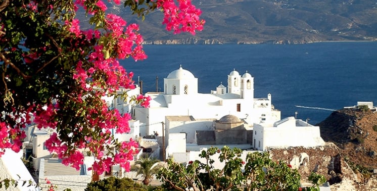
Once you rent a car, an ATV or a buggy from Rac SA, take the road to Plaka.
Plaka is the capital of the island, built on a hill at a height of 220 meters. With its island color, quaint cobbled streets, small shops, restaurants and cafes, and the stunning view of the bay of Milos, Plaka will amaze you.
Milos Advisor places Plaka within the island’s hill country above the harbour. This settlement is the island capital and municipal seat. Its setting joins a rocky height, the gulf below, and a compact group of Cycladic streets. The village gives a clear starting point for reading the nearby churches, museums, ancient ground, and linked hill settlements.
Plaka stands apart from the port while remaining part of the same western side of Milos. The route upward changes the view from harbour level to the gulf and its rim. Within the settlement, built forms replace open road space. Lanes, church courtyards, public buildings, and the castle hill create a close sequence of places, with ancient sites continuing beyond the houses.
What defines Plaka Milos as the capital on the hill?
Plaka Milos is the capital of the island, set at 220 metres above the gulf. It combines a hilltop position, a compact traditional settlement, and views toward the bay, while its lanes follow a built environment where cars do not enter.
Plaka Milos occupies a hill above the harbour area and looks across the gulf of Milos. The settlement lies at 220 metres, a height that gives the village a direct relation to the water and the slopes below. Its role as island capital brings civic importance to a place with small-scale built fabric. Rather than spreading across flat ground, Plaka Milos gathers streets, houses, churches, and public functions around the upper hill and the Kastro.
The position of Plaka Milos also explains its long view. From the upper settlement, the gulf opens below the hill, while the surrounding Cycladic landscape frames the western side of the island. The older defensive height stands above the ancient city, and the medieval town formed on the plateau beneath it. This vertical order gives a layered form: the Kastro at the high point, built streets lower down, and the bay beyond the slope. The view belongs to the village structure, not to one stopping point.
In Plaka Milos, the settlement pattern is closely tied to the narrow space between walls and buildings. Cars do not enter the village, so the interior keeps the scale of lanes and pedestrians. Houses sit close, and the route through the centre passes short turns, small rises, and church fronts. The white Cycladic building tradition appears in the compact forms and plain surfaces. This arrangement makes the hill feel continuous, from the lower approaches to the ground below the castle.
The name Plaka relates to level ground where houses were built when the Kastro no longer held the population. That detail links the village name to its growth beyond the fortified height. Plaka Milos is therefore not only the crest of the hill: it includes the plateau and the streets that expanded under the castle. The village remains the island’s chief town, yet its physical shape stays tight. Its roads and paths answer the rock, the slope, and the earlier fortified core.
- Role: Plaka is the chief town and municipal seat of Milos.
- Height: Plaka stands at 220 metres above sea level.
- Setting: The village looks over the gulf of Milos from a rocky hill.
- Layout: The medieval town formed on the plateau immediately below the Kastro.
- Traffic: Cars do not enter the settlement because space between walls and buildings is narrow.
Seen from the hill, Plaka Milos brings geography and settlement into one frame. The bay explains the outward view, while the rock explains the inward pattern of lanes and close houses. The upper village is a place for slow movement rather than through traffic. Its capital role does not erase this scale. Instead, the island’s public identity sits within a settlement shaped by height, stone, and the route to the Kastro.
How do the Kastro and churches shape Plaka Milos?
Plaka Milos rises toward the Kastro, an ancient monument on a volcanic hill above the old city. Along this ascent, Panagia Thalassitra and Panagia Korfiatissa mark two church settings, while the crest and western edge open toward the gulf and sunset.
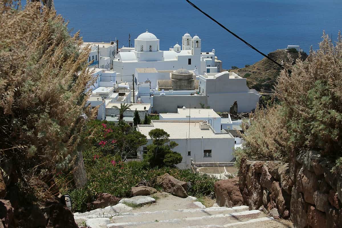
The Kastro of Plaka Milos occupies the settlement’s highest point on a hill of volcanic origin. Venetian builders created it in the 13th century, and its position above the ancient city allowed control of ships in the gulf of Adamantas. The foundation is placed after 1204. Below the fortified height, the medieval town developed as the Kastro’s extension. This relation remains legible in the climb, where the village rises from its streets toward the rock and the old defensive centre becomes the upper landmark.
Panagia Thalassitra stands on the climb toward the Kastro in Plaka Milos. The church also carries the name Presentation of Christ. It sits below the summit, where the church of the Dormition of the Virgin, also called Mesa Panagia, crowns the castle summit. The contrast between these locations gives the ascent a clear sequence. One church stands along the approach; the other occupies the top. Both connect religious space with the village’s upper defensive ground.
At the western end of Plaka Milos, Panagia Korfiatissa is the Church of the Nativity of the Virgin and the cathedral of Milos. Its building date is 1820, and its form joins Byzantine and Cycladic elements. The Folklore and History Museum stands behind this church, placing domestic history beside a church that anchors the western side of the village. The church court faces the open direction of the gulf, creating another point where built space and the outward horizon meet.
The Kastro and church settings give Plaka Milos more than one high viewpoint. The castle hill looks over the gulf and neighbouring Cycladic islands, while the western church area faces the open sea direction. These places are not detached landmarks. They are linked by the village lanes, the ascent, and the slope that leads from the houses to the upper rock. At sunset, the height, western exposure, and open bay combine in a view defined by the settlement’s own terrain.
- Kastro: The fortified site stands on the highest point of the Plaka hill.
- Origin: Venetian builders created the Kastro in the 13th century after 1204.
- Thalassitra: Panagia Thalassitra is the Presentation of Christ on the route toward the Kastro.
- Mesa Panagia: The Church of the Dormition of the Virgin crowns the castle summit.
- Korfiatissa: Panagia Korfiatissa is the cathedral of Milos at Plaka’s western end.
The upper landmarks of Plaka Milos work as a connected hill walk. The Kastro provides the summit, Thalassitra sits on the approach, and Korfiatissa defines a western church court. Their shared setting explains the village’s double reading: lanes lead upward through the built area, then the ground opens toward the gulf. The result is a close encounter with settlement history and a broad outlook over the bay.
Which museums and ancient sights are near Plaka Milos?
Plaka Milos brings the Archaeological Museum and the Folklore Museum into the village, while the Catacombs, the ancient theatre, and the Venus de Milo find place lie on the island beyond it. These places connect village streets with material from prehistoric, ancient, Roman, Christian, and later island life.
The Archaeological Museum of Milos stands in Plaka Milos, in a neoclassical building on the main square. Its collections range from the late Neolithic to the Byzantine period and include Cycladic art, finds from Phylakopi, pottery, obsidian tools, inscriptions, and sculpture. A modern copy of the Venus de Milo stands in the first room. The museum turns the village centre into a place where island objects sit within the present capital. Its building itself dates from 1870.
Behind Panagia Korfiatissa, the Folklore and History Museum of Milos presents aspects of Melian life after the 17th century. In Plaka Milos, its rooms include a living room, workplace with a loom, kitchen, bedroom, cellar, and upper floor used as a historical record. Furniture, textiles, clothing, housewares, decorative objects, everyday objects, and old photographs shape the display. The museum adds household life to a village already marked by churches, public services, and the archaeological collection.
Beyond Plaka Milos, the Catacombs lie on the hillside southwest of Tripiti, in the area of the ancient city and near the seaside village of Klima. These underground spaces are a cemetery of the first Christian centuries. Halls and corridors were carved in soft porous volcanic rock, and their galleries extend about 200 metres. The ancient Theatre of Melos lies between Trypiti and Klima on the slope where the ancient city stood. Seven marble rows of seats, the orchestra, stage floor, and architectural parts survive from its Roman phase.
The Venus de Milo was found in a rural area of Milos in 1820 and is displayed at the Louvre in Paris. A faithful copy of the statue is kept in the Archaeological Museum of Milos. The statue is an ancient Greek marble work of the Hellenistic period, made of Parian marble. The ancient ground near Tripiti, where the theatre and catacombs stand, gives context to the slopes below Plaka Milos and to the wider archaeological landscape.
- Archaeological Museum: The collection in Plaka includes material from the late Neolithic to the Byzantine period.
- Folklore Museum: The museum stands behind Panagia Korfiatissa and presents later Melian household life.
- Catacombs: The underground cemetery lies southwest of Tripiti in soft volcanic rock.
- Theatre: The Theatre of Melos preserves seven marble rows of seats from its Roman phase.
- Venus de Milo: The ancient Greek marble sculpture was discovered on Milos in 1820.
The museum and ancient sites around Plaka Milos form a compact cultural circuit without reducing the village to one period. Inside Plaka, objects and household rooms show different parts of island history. Outside it, the theatre, catacombs, and Venus de Milo find place extend the story across the slope toward Klima. This range allows the capital to be understood as a living hill settlement beside an archaeological landscape and not as a separate stop.
What is walking through Plaka Milos like?
Plaka Milos is a pedestrian settlement of narrow lanes and closely placed houses, with cars stopping outside its inner streets. The walk joins the capital to nearby Tripiti and Triovasalos, while the hill route brings churches, the Kastro, ancient ground, and gulf views into one area.
Walking through Plaka Milos follows lanes shaped by the tight space between walls and buildings. Cars do not enter the village, so the inner streets keep a pedestrian character. Motorbikes and mopeds are the usable vehicles. The walk moves through a dense built setting, not along a broad road. White houses, small rises, turns, and church fronts keep the route close to the ground. This street pattern leads naturally toward the Kastro and toward the lower links with nearby villages.
Plaka Milos belongs to a hill cluster above Adamantas with Triovasalos, Pera Triovasalos, Plakes, and Tripiti. The villages of Milos share short links on the same height above the port. Tripiti stands at 150 metres and is almost joined to Plaka, while Triovasalos stands at 143 metres and Pera Triovasalos at 120 metres. A hiking route links Plaka and Tripiti. These nearby settlements extend a village walk beyond the capital without leaving the raised ground above the gulf.
Tripiti stands on slopes beside the remains of the classical city of Klima. Its name comes from soft volcanic rock that appears pierced, and the village keeps old windmills. Near Tripiti, the catacombs and ancient theatre lie within walking distance. Plaka Milos and Tripiti thus share both a hill route and an ancient setting below their houses. The walk changes from the enclosed lanes of the capital to slopes, theatre ground, and the route toward Klima by the coast.
Triovasalos and Pera Triovasalos occupy neighbouring hills and once formed one settlement until 1908. From Plaka Milos, their streets belong to the same upper group. Plakes stands between Plaka and Triovasalos at the foot of the Kastro, making another link in the hill pattern. The village connections are close, but each place has its own elevation, church landmarks, and relation to the slope. A walk through the area is therefore a sequence of distinct settlements rather than a single uninterrupted street.
- Lanes: Plaka’s inner streets are narrow because houses and walls stand close together.
- Cars: Cars remain outside the village interior, where motorbikes and mopeds fit the lanes.
- Tripiti: Tripiti is almost joined to Plaka and links to the catacombs and ancient theatre.
- Triovasalos: Triovasalos stands on the same hill cluster above Adamantas.
- Plakes: Plakes lies between Plaka and Triovasalos at the foot of the Kastro.
A walk through Plaka Milos is shaped by a simple change of scale. Vehicles stay at the edge, then the route passes into narrow lanes, church settings, and the climb toward the Kastro. Beyond the capital, Tripiti and Triovasalos continue the hill pattern with short links between settlements. The route is not one street alone. It is a connected highland area where houses, ancient sites, and views over the gulf meet on foot.

What do travellers ask about Plaka Milos?
Plaka Milos is the island capital on a 220-metre hill above the gulf, where the Kastro, churches, museums, narrow lanes, and nearby ancient sites shape a concentrated visit. The answers below focus on location, landmarks, walking links, and the setting around the old city.
Where is Plaka Milos located?
Plaka Milos stands on a hill above the gulf of Milos, at 220 metres above sea level. It is the island’s chief town and municipal seat. The settlement rises around the Kastro, with the medieval town on the plateau directly below. Its place above the harbour brings views over the gulf while the streets within the village stay narrow.
Why does Plaka Milos have no cars in its centre?
Plaka Milos has narrow spaces between walls and buildings, so cars do not enter the village. The restriction keeps the inner lanes for pedestrian movement. Motorbikes and mopeds are the usable vehicles in these passages. This arrangement reflects the compact layout of the settlement, where houses and church fronts share limited space on the hillside.
What is the Kastro above Plaka Milos?
Plaka Milos rises to the Kastro, a fortified site on the highest point of a volcanic hill. Venetian builders created it in the 13th century, after 1204. The Kastro stands above the ancient city and once allowed control of ship movement in the gulf of Adamantas. The medieval town formed on the plateau beneath the fortified hill.
Which churches stand in Plaka Milos?
Plaka Milos includes Panagia Thalassitra on the route toward the Kastro and Panagia Korfiatissa at the western end of the village. Thalassitra is also called the Presentation of Christ. Korfiatissa is the Church of the Nativity of the Virgin and the cathedral of Milos. Mesa Panagia, the Church of the Dormition of the Virgin, stands at the castle summit.
Which ancient sites are near Plaka Milos?
Plaka Milos lies near the Catacombs on the hillside southwest of Tripiti and the ancient Theatre of Melos between Trypiti and Klima. The catacombs are an underground Christian cemetery carved in porous volcanic rock. The theatre preserves marble seating, the orchestra, and the stage floor from its Roman phase. A copy of the Venus de Milo stands in the museum.
How does Plaka Milos connect with Tripiti and Triovasalos?
Plaka Milos forms part of a hill cluster with Tripiti, Triovasalos, Pera Triovasalos, and Plakes above Adamantas. Tripiti is almost joined to Plaka, and a hiking route connects the two. Plakes lies between Plaka and Triovasalos at the foot of the Kastro. These settlements give short walking links across the raised ground.