Route No. 3 covers a distance of 3.3 km and lasts about 5-6 hours. We set off from Adamas by car and, after a 50-minute drive to western Milos, a designated area protected by Natura 2000, we arrive at “Platorahes“. We leave the car and hike for about 50 minutes along the natural path towards “Kleftiko“. We take a short break and get ready to explore the surrounding caves by snorkelling. We go back to the shore for food and relaxation, and then we start the trip back.
Price: 35 euros
Milos is a volcanic island in the south-western Cyclades, and its western half is the wildest ground on the island. A walk that starts at Platorahes and ends at Kleftiko crosses that ground on foot, then drops into the sea caves below the cliffs. The day belongs with the other outdoor plans set out on the island of Milos.
The Kleftiko hike Milos route is short on paper but long in what it holds: a drive across protected land, a path over tuff and pumice, and a swim inside caves cut by the sea. Six parts follow, from the road out of Adamas to the boats that reach the same coast from the water.
What does the Kleftiko hike Milos route cover from Adamas to the caves?
The Kleftiko hike Milos route covers 3.3 km between the harbour town of Adamas and the south-western coast. A car crosses the island to Platorahes, the walk continues along a natural path towards Kleftiko, and the day closes with a swim through the sea caves.
Adamas is the main port of Milos and the centre of its trade. Cretan refugees founded the town, and it stands beside a bay among the largest natural harbours of Greece. For the Kleftiko hike Milos day, a car leaves that bay and turns inland, away from the water. Houses thin out, the surface turns to dirt, and the traffic disappears. The first stage of the day is therefore a crossing of the island by road, not a walk.
The road ends at Platorahes in the south-west, and the car stays there for the rest of the day. From that point the route continues on foot, along a natural path that runs towards the sea. The path crosses open land with thin scrub, and the line of the coast shows the way once the water comes into view. No village stands on the stretch, so the walker carries everything needed for the day, including the full water supply.
The path leads towards Kleftiko, on the south-western coast of the island. The ground is volcanic and dry, and the route follows a natural path rather than a road. The walk covers 3.3 km in all, from the car stop to the shore. The final stretch drops towards the coast, where white cliffs and small islands close the view, and the open sea lies beyond them. A break on the shore comes before the return.
At the shore the walking part ends and the water takes over. The group leaves bags on the rocks and enters the water to explore the caves that open along the cliff line. The sea inside the bays is calm and clear, so the swimmer sees the white rock walls under the surface. The swim follows the line of the cliffs, and the openings come one after another. A short break follows on the shore, and then the return begins.
A day on this coast holds three stages: a drive, a walk and a swim. The drive crosses the island to a protected western area, the walk follows a natural path to the coast, and the swim moves through the caves that the sea cut into the rock. The Kleftiko hike Milos route covers 3.3 km. It sits beside the other combined activities in Milos, where two outdoor sports share one day.
- Distance: The Kleftiko hike Milos route covers 3.3 km from the car stop at Platorahes to the coast.
- Start: Adamas is the meeting point, and the crossing to the west is made by road.
- Footpath: A natural path runs from Platorahes towards Kleftiko, over dry volcanic ground.
- Finish: The caves below the cliffs hold the swim that closes the day.
- Return: The trip back follows the same path and the same road to Adamas.
What does the west of Milos hold on the way to the Kleftiko hike Milos trailhead?
The Kleftiko hike Milos drive crosses the western half of Milos, the wildest ground on the island. Almost all of that land belongs to the Natura 2000 network, it holds no villages, and only a pozzolan mine still works there, at Xylokeratia.
The western half of Milos is the wildest part of the island. No village stands there, and only a small number of settlements and old mines break the open ground. The one mine still working is the pozzolan mine at Xylokeratia. Dirt tracks carry the traffic that remains, and they run for long distances between the coast and the high ground. For the Kleftiko hike Milos route, that emptiness is the point of the drive.
Almost all of western Milos belongs to the Natura 2000 network. Inside it lies Achivadolimni, once full of clams and now the largest natural wetland of the Cyclades, a stop for migratory birds. A forest of horizontal-branched cypresses also grows in the west, a rare habitat with centuries-old trees. Plants, herbs and wildflowers cover the ground, and protected birds such as Eleonora’s falcon nest there. The wetland draws the birds, and the dry land draws the plants.
Wildlife gives the western half a second reason for protection. The south-western side of Milos is a habitat of the Mediterranean seal, and the caves of the coast below Kleftiko served the animals as breeding places. The rest of the west is a habitat of the Milos viper and of a small lizard found on the island. Walkers on the Kleftiko hike Milos path cross this ground in daylight, and the animals stay out of sight.
The shape of the island decides what the drive shows. Milos is the fifth largest island of the Cyclades, 23 km across from north-east to south-west and 13 km from north to south. It lies 102 km from the Peloponnese, and its form is that of a horseshoe around a large gulf. Profitis Elias rises to 751 metres, the highest point, and Chondro Vouno reaches 636 metres in the western part. Both summits stand in the west, above the road to Platorahes.
The road to the Kleftiko hike Milos trailhead is therefore a crossing of protected, empty land. The west has no village, one working mine and a coastline that belongs to a European network of protected areas. Achivadolimni holds the water, the cypress forest holds the old trees, and the two summits hold the skyline. The walking routes of Milos continue on the same ground beyond Platorahes.
- Achivadolimni: The largest natural wetland of the Cyclades lies inside the western area crossed by the Kleftiko hike Milos drive.
- Cypresses: A forest of horizontal-branched cypresses grows in the west, with trees of great age.
- Falcon: Eleonora’s falcon, a rare migratory bird of prey, is a protected species of the west.
- Mine: The pozzolan mine at Xylokeratia is the only working mine in the western half.
- Seal: The south-western coast is a habitat of the Mediterranean seal.

What makes Kleftiko itself the end point of the Kleftiko hike Milos path?
The Kleftiko hike Milos path ends at white cliffs and small islands spread over three bays. Sea and wind eroded the volcanic rock into hollows and caves, and the same bays served as a base for pirates during the era of Mediterranean piracy.
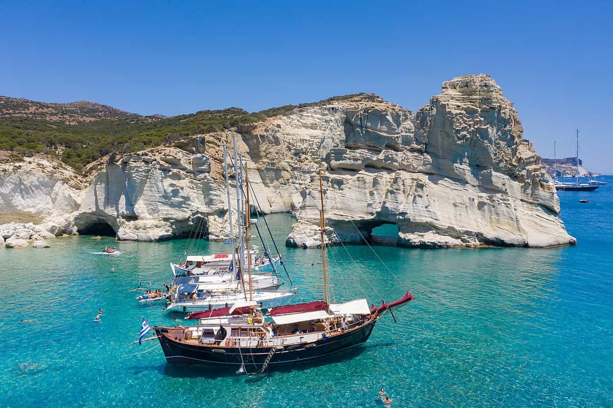
Kleftiko is an area on the south-western side of Milos. White cliffs and small islands rise from the sea there, over three bays that follow one another. The rock is volcanic. Tuff makes up the walls, in shades from white and light yellow to dark, and the beds of pumice inside the tuff formed layers about 3.1 million years ago. Basalt also lies in the ground around Kleftiko. The stone changes colour with the light.
The shape of the place comes from erosion. Sea and wind worked on the rock and cut hollows and caves into it, and those openings give the coast its present look along the water line. The same coast has been named a landscape of special natural beauty, and it belongs to a Natura 2000 area. From the water, the cliffs of the Kleftiko hike Milos coast appear as a group of enormous grey-white rocks with caves between them.
The name of the place comes from the era of Mediterranean piracy. The three bays worked as a base for pirates against passing ships, and the caves of the area served as shelters when the weather turned bad. The position explains the choice, because the bays hide a boat from the open sea and the cliffs screen it from the land on that side. Pirates therefore belong to the history of the Kleftiko hike Milos coast.
Fishermen of the region report a second use for the caves. Mediterranean seals came to them as breeding places, and the animals found shelter in the same openings that hid the boats. The caves are thought to be abandoned by the seals now, because visitors reach the area in numbers. The south-western side of Milos remains a habitat of the Mediterranean seal, and the coast of the Kleftiko hike Milos walk lies on that side.
Kleftiko is therefore a place of white rock, dark openings and old stories. The cliffs and islands sit in three bays, the tuff and pumice date the rock, and the caves carry both the memory of piracy and the memory of the seals. The Kleftiko hike Milos path reaches the coast on foot, and the boats reach the same shore from the sea.
- Cliffs: White cliffs and small islands rise from the sea over three consecutive bays.
- Rock: The walls are tuff, with beds of pumice formed about 3.1 million years ago.
- Caves: Sea and wind cut hollows and caves into the volcanic rock.
- Name: The place takes its name from the era of Mediterranean piracy.
- Seals: Fishermen report that Mediterranean seals used the caves as breeding places.


What lies under the water on a Kleftiko hike Milos snorkel?
A Kleftiko hike Milos snorkel moves through caves cut into white volcanic rock, with pumice layers and basalt around them. The water stays clear, the bays shelter it from open swell, and a mask and fins open the cave line to a swimmer.
The swim follows the same rock that the path follows on land. The walls of the caves are tuff, and the pumice inside it lies in beds, so the surface under the water shows band after band of pale stone. Basalt appears in the ground around the area. The colour of the rock and the colour of the water work together, because the clear sea shows the pale stone and the walls of the Kleftiko hike Milos caves.
The openings themselves are the main sight. Sea and wind cut the hollows and caves into the rock, and the openings run along the cliff line of the three bays. A swimmer moves from one opening to the next, and each one gives a different shape of roof and wall. The caves also served as shelters in bad weather, which shows how well the rock closes around the water on the Kleftiko hike Milos coast.
The behaviour of the sea decides how the swim feels. Kleftiko faces the south-west, and its bays form sheltered coves where boats anchor in calm water. The island has more than 75 beaches, and the direction of the wind decides which of them stay calm: with the meltemi and the north winds, the south side and the waters inside the gulf hold the calmest sea. That rule applies to the Kleftiko hike Milos swim as well.
Below the surface, the same protected status applies. The south-western side of Milos is a habitat of the Mediterranean seal, and the caves of this coast were used by the animals as breeding places. The water is clear, the light reaches the pale walls, and the openings give a swimmer a route through the rock. A mask and fins are the whole kit for the Kleftiko hike Milos snorkel. The swim keeps to the bay line, where the water stays calmest.
The underwater part of the day is a slow pass along a line of caves. Tuff walls, pumice beds and basalt sit under clear water, the bays hold the swell back, and the openings offer one shape after another. The Kleftiko hike Milos snorkel ends where it began, on the shore below the path, before the walk back to the car.
- Walls: The caves are cut into white tuff, with beds of pumice inside the rock.
- Basalt: Dark basalt lies in the ground around Kleftiko, beside the pale tuff.
- Calm: The three bays form sheltered coves where the water stays quiet.
- Wind: In the meltemi and the north winds, the south side of the island holds the calmest sea.
- Kit: A mask and fins are enough for the swim through the caves.
What to carry and when to go on a Kleftiko hike Milos day?
A Kleftiko hike Milos day asks for a full water supply, sun cover and boots with ankle support. Spring and autumn give the mildest weather, and the meltemi, the dry north wind of the Aegean, decides which side of the island stays calm.
Water comes first. Two litres can cover a day of walking, and hot conditions can raise the need to one litre for every hour on the path. Water found in the countryside can be unfit to drink, so the full supply starts at the base. Sweat takes salt out of the body as well as water, and salty snacks eaten with the water put the salt back. On the Kleftiko hike Milos path, no village offers a refill.
Sun cover comes next. Sunburn can happen in hot weather and in cold weather alike, and the standard list of essentials names sunglasses, sun protective clothing and sunscreen, with a hat as a further item. Ordinary summer cloth carries a sun protection factor of about 6, while sun protective clothing reaches about 30 and lets through about 3 percent of ultraviolet light. The pale rock of the Kleftiko hike Milos coast throws light back at the walker.
Footwear decides how the day ends. Boots protect the feet and the heels, support the ankle and carry stiff soles, and loose gravel on smooth rock rolls under a thin sole. Ankle sprain makes up 42 percent of hiking injuries, and boots with ankle protection lower that risk. Footwear that is neither too loose nor too tight keeps blisters away, which matters over the dry ground of the Kleftiko hike Milos route. On the Kleftiko hike Milos path, thin soles turn loose stone into a hazard.
The wind and the month set the rest. The meltemi is a dry north wind that tempers the summer heat, and it can blow at force 7 to 8 out of a clear sky, so an early start beats the afternoon. April has a daily mean of 15.2 degrees Celsius and 2.9 rainy days, September has 22.3 degrees and 0.9 rainy days, and October has 18.5 degrees. June, July and August record 0.3, 0.1 and 0.1 rainy days.
Three habits carry a walker through the day: a full supply of water, covered skin and boots that hold the ankle. The month matters as much as the kit, because spring and autumn bring mild air and little rain, while midsummer brings the dry north wind and strong heat. The Kleftiko hike Milos route is short, and the conditions around it decide the comfort of the walk.
- Water: Two litres can cover a day, and heat can raise the need to a litre an hour.
- Sun: Sunglasses, sun protective clothing, sunscreen and a hat belong in the bag.
- Footwear: Boots with stiff soles and ankle support cut the risk of sprain and blisters.
- Wind: The meltemi can blow at force 7 to 8, and it peaks in the afternoon.
- Season: April, September and October bring mild air and little rain to the west.
How is Kleftiko reached by sea instead of the Kleftiko hike Milos path?
The Kleftiko hike Milos coast is also reached from the water, because boats leave daily from the harbours of Adamas and Pollonia. The sea route passes beaches with no road, stops at the Sykia cave, and reaches Kleftiko, where masks and fins are handed out.
Sea excursions give access to places that no road serves. Boats, small fishing craft and sailing boats are offered for these trips, and they carry visitors to beaches that cannot be reached from the land, to clear water for a swim, and to hidden caves. The same trips reach the neighbouring islands. For the Kleftiko hike Milos coast, the sea is the second way in, and the boats leave daily from the harbour of Adamas and from Pollonia.
The Kleftiko hike Milos coast passes a series of named places, one after another. After Adamas come the small fishing settlements of Skinopi, Klima, Areti and Fourkouvouni, and then the cliffs known as the Bears. Cape Vani follows, with the old mines below it. The boats then reach Kalogries in western Milos, where the water is emerald green, and sail past the beaches of Agkathia, Triades, Ammoudaraki and Agios Ioannis on the way south of the island.
The stop at Sykia comes before Kleftiko. Sykia is a cave on the west coast whose roof has collapsed, so light enters from above, and a swim inside it is part of the trip. The boats then reach Kleftiko itself, where the sea route ends. Masks and fins are handed out, diving takes place from the boat and from the rocks, and the Kleftiko hike Milos coast is seen from the water rather than from the path.
The return carries its own scenery. A meal is served on the boat or on the shore of Thieves’ Beach, and the final stretch back to Adamas runs under open sails. The one-day cruises from Adamas follow this line. The second harbour, Pollonia, works the same coast from the north-east, and its boats leave daily as well. The boats of the two harbours cover the same shore that the Kleftiko hike Milos path covers on foot.
The sea gives the Kleftiko hike Milos coast a second reading. From the water, the caves, the cliffs and the three bays appear in sequence, with a stop at the collapsed cave of Sykia on the way. The boats leave daily from Adamas and from Pollonia, and the shore that the path reaches on foot is the shore that the sea reaches in the afternoon.
- Adamas: Boats for the west coast and for Kleftiko leave this harbour daily.
- Pollonia: The second harbour also sends boats out daily, from the north-eastern side.
- Sykia: A cave on the west coast, with a roof that has collapsed, comes before Kleftiko.
- Stop: At Kleftiko, masks and fins are handed out for diving from the boat and the rocks.
- West line: The trip passes Skinopi, Klima, Areti, Fourkouvouni and the cliffs called the Bears.

What do visitors ask about the Kleftiko hike Milos route?
The Kleftiko hike Milos route raises questions about its length, its ground, its season and its water. The answers below cover the 3.3 km line from Platorahes, the caves at the end, the wind that shapes the coast, and the boats that reach the same shore.
How long is the Kleftiko hike Milos route in distance?
The route covers 3.3 km in all, from the car stop at Platorahes to the coast below Kleftiko. The walking part follows a natural path over dry volcanic ground, and the swim through the caves comes at the end. The drive from Adamas is a separate stage, made by car on the road.
What ground does the Kleftiko hike Milos path cross?
The path crosses volcanic ground in the western half of Milos, a part of the island with no village on it. Dirt tracks, thin scrub and open rock make up the surface, and the track is not distinct along its whole length, so the line of the coast works as the marker.
When is the Kleftiko hike Milos season at its mildest?
Spring and autumn give the mildest conditions for the Kleftiko hike Milos day. April has a daily mean of 15.2 degrees Celsius and 2.9 rainy days, September has 22.3 degrees and 0.9 rainy days, and October has 18.5 degrees. June, July and August record 0.3, 0.1 and 0.1 rainy days.
Which wind suits a Kleftiko hike Milos swim?
The meltemi is a dry north wind that tempers the summer heat, and it can blow at force 7 to 8 out of a clear sky. It decides which water stays calm, because the south side of the island holds the quietest sea under north winds. The sheltered coves of Kleftiko give the same calm for anchoring.
What footwear suits the Kleftiko hike Milos path?
Boots with stiff soles and ankle support suit the ground of the Kleftiko hike Milos path. Loose gravel on smooth rock rolls under a thin sole, and ankle sprain makes up 42 percent of hiking injuries, so ankle protection lowers the risk. Footwear that is neither too loose nor too tight keeps blisters away.
Can a Kleftiko hike Milos day include children?
The route covers 3.3 km, which is short enough for a family walk, and the swim through the caves gives children a clear goal at the end. Water, sun cover and shoes matter more here than on a village walk, because no village lies on the way. The day suits a group that starts early.
Is the Kleftiko hike Milos coast reached without a boat?
Yes. Kleftiko is accessible by excursion boats or by a path, so the coast can be reached on foot from Platorahes. The walking route covers 3.3 km and ends at the shore, where the caves open along the cliff line. The boats reach the same shore from Adamas and Pollonia.
What is seen beneath the water on a Kleftiko hike Milos swim?
The caves are cut into white tuff, and beds of pumice run through the rock, so the walls under the water show pale bands of stone. Dark basalt lies in the ground around the area. The water is clear, so light reaches the walls, and the Kleftiko hike Milos caves show one opening after another.