Hiking in Milos means walking on bare volcanic ground, where white tuff meets the sea and dirt roads cross dry hills. The island of Milos has three numbered routes, one along the coast, one through villages and one to a cave, and all three cross land shaped by volcanoes. Each route has its own start and its own end.
Two sections follow. The first sets out what hiking in Milos asks of a walker in ground, old paths, heat and shade. The second takes Route 1, Route 2 and Route 3 in order, from the first step to the last, and names the places each route passes on the way. Each section ends with a short list of facts.
What is hiking in Milos like on volcanic ground, old paths and bare slopes?
Hiking in Milos means crossing volcanic rock, soft white tuff and dirt roads on a dry island. Routes run along the coast and between old villages, shade is thin, and in summer the white rock throws strong sunlight back at the walker.
Hiking in Milos begins on volcanic ground. Tuff, trachyte and obsidian are among the ordinary rocks of the island, and the north shore adds layers of pumice that dominate as far as Mytakas. Past Mytakas the route crosses tuff covered with low scrub. At Sarakiniko, rain runs through a small ravine between soft white rocks and sculpts its bed, and walking in the ravine is not easy. On the road from Nychia to Tripiti, the tuff formed from older volcanic debris altered by the sea, as marine fossils show.
Old paths and farm land still shape hiking in Milos. From the end of the road between Tripiti and the catacombs, an alley leads on foot to the walls of the ancient city, close to the spot where the Aphrodite of Milos was found. On the road toward Tripiti, a small plateau once grew wheat and barley. In Plaka, cobbled alleys first built as protection from pirates climb toward the Venetian castle of the 13th century.
Heat and shade set the pace of hiking in Milos. The mean daily maximum reaches 28.1 degrees Celsius in July, and the record high of 44.0 degrees was set in June. July averages 0.3 mm of rain. The island is too dry for dense vegetation. Olive, cypress, juniper and arbutus trees grow on it, tamarisk trees stand at Pachena, and young cedars are scattered beyond Mytakas, but the white rock around Sarakiniko has no green around it.
- Footwear: Hiking boots protect feet and ankles on rough ground such as rock shelves and dirt roads.
- Hazards: Dehydration, sunburn and sunstroke are named hazards of any hike.
- Warm months: From June to September, hiking in Milos takes place at a mean daily maximum of 25.2 to 28.1 degrees Celsius.
- Autumn: The mean daily maximum falls from 21.3 degrees Celsius in October to 18.0 in November.
- Humidity: Mean relative humidity is 58.8 percent in June and 60.1 percent in July.
Seen as a whole, hiking in Milos is rough, dry and bright. Tuff, pumice and white rock shelves decide the footing, old alleys and farm plateaus decide where the paths run, and thin scrub decides how much shade a route offers. The three numbered routes put all of this on one map, with a coast route, a village route and a cave route.
Which three routes make up hiking in Milos, and what does each one pass?
Hiking in Milos has three numbered routes, and each ends in a different place: Route 1 at the white rock of Sarakiniko, Route 2 in the capital Plaka, and Route 3 at the roofless cave of Sykia. The routes cover 6.7, 5.9 and 2.1 km.
The first of the routes for hiking in Milos covers 6.7 km along the northern coast. It starts at the three Papafragkas caves beside the ruins of ancient Phylakopi, and passes Kapros, a small cove between white rocks. The two Pachena beaches face the Glaronisia islets, and hexagonal volcanic formations follow. The route passes Agios Konstantinos, where a church is dug into soft rock, then Alogomantra and the islet of Kofto, crosses almost one kilometre of white formations beside the sea, reaches Mytakas, and ends at Sarakiniko beach.
The second route for hiking in Milos covers 5.9 km between the catacombs and the capital. It starts at the catacombs near Tripiti, three underground galleries cut into porous volcanic rock, where one gallery is open to visitors. The route descends past the church of Agia Paraskevi to Klima, the site of the first port of the island. It climbs to the Roman theatre, the baptism place and the church of Prophet Elias, drops to Tramithia and the church of Saint Nicholas, and rises through Areti to Plaka.
The third route for hiking in Milos covers 2.1 km and starts with a car transfer from Adamas. The road crosses west Milos, a Natura 2000 area, to the monastery of Saint John Siderianos at Halakas in the south-west. From the monastery a natural path leads on foot to Sykia, the biggest cave on the island. The path is easy except for the last 200 metres, where steep ground makes the going slightly difficult. The cave has no roof, so sunlight enters and lights the emerald water.
- Papafragkas: The beach below the caves served as a pirate base in Byzantine times.
- Alogomantra: This strip of sand lies between high cliffs and is not visible from the road.
- Catacombs: The galleries lie 150 metres above sea level, with 126 carved tombs preserved on their walls.
- Theatre: The Roman theatre of Parian marble is estimated to have held about 7,000 spectators.
- Monastery: A shell fired by a British warship in the Second World War stuck in the church wall without exploding.
The three routes give hiking in Milos a coast, a town and a cave. Route 1 offers white rock and small beaches, Route 2 offers catacombs, ancient remains and villages, and Route 3 offers a short walk through the protected west. The page on the activities on Milos places these walks beside the other ways to explore the island, on land and at sea.

Where does coastal hiking in Milos run along the north coast?
Hiking in Milos along the north coast follows the shore over level rock from Papafragas to Sarakiniko, past Mytakas and the islet of Kofto. Pollonia and its cape close the same coast in the east, and the sea stays beside the walker the whole way.
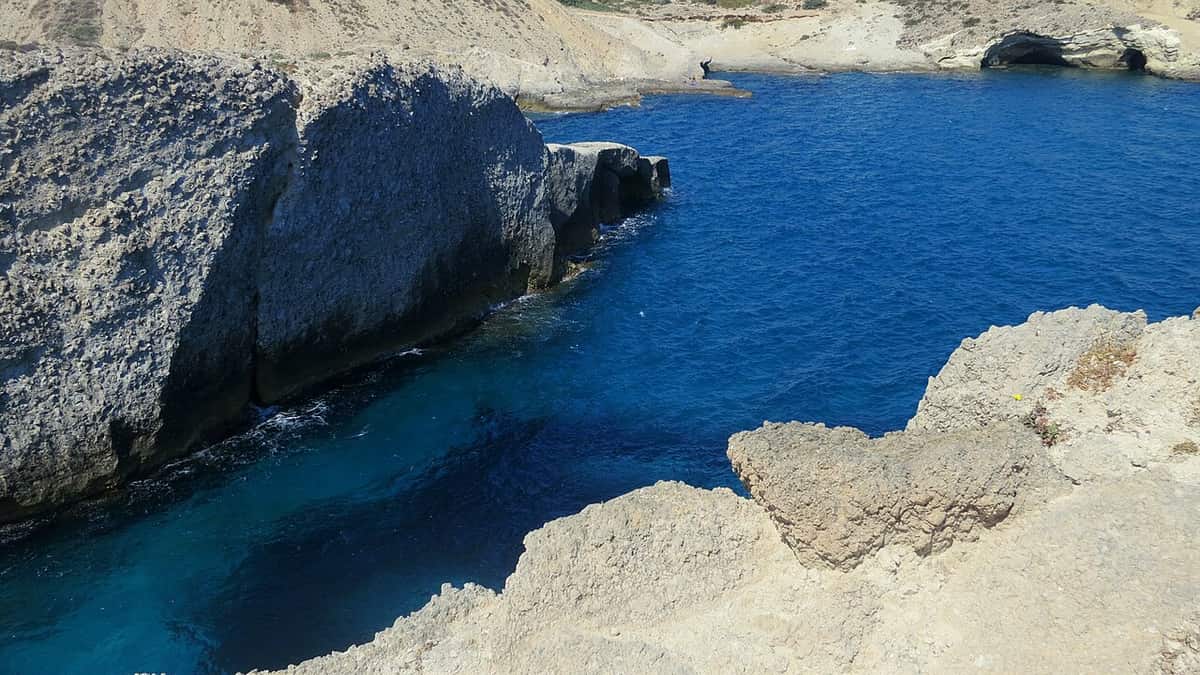
Coastal hiking in Milos on this shore begins at Papafragas, where the small beach lies at the bottom of a steep cut in the rock, next to the ruins of Phylakopi and the three caves. From Papafragas to Sarakiniko the walk covers 6.7 km. Hexagonal volcanic formations, similar to those of Glaronisia, appear along the way, and for almost one kilometre the route crosses white geological formations beside the sea. Hiking in Milos on this coast changes its ground from one cove to the next.
The shorter stretch from Agios Konstantinos to Sarakiniko covers about 4.5 km. Agios Konstantinos lies in a small fjord that gives only basic shelter from the weather. The walk starts on the dirt road that drops to the beach 200 metres west of the settlement. The path is not distinct along its whole length, but the line of the coast shows the way, over level rock that is easy to cross. Hiking in Milos on this stretch keeps to the coastline, and the coastline works as the marker.
Past the beach of Agios Konstantinos, the second small cape is split by faults and cut off from the coast. Local people call the islet Kofto, and a small colony of gulls lives there. Layers of pumice dominate the shore as far as Mytakas, a sandy beach between narrow capes. Beyond Mytakas, the route runs over tuff with the same dry scrub, and the small beaches that follow lead to Sarakiniko, where hiking in Milos on this shore ends.
Pollonia closes the north coast at its north-eastern tip. The village stands only 10 metres above the sea, so a shore walk from it begins at the water. The cape of Pelekouda carries the lighthouse, and the name of the village is tied to a temple of Apollo that stood at that lighthouse. Pelekouda is a peninsula worth a visit, and Piso Thalassa, a beach near the village, has a name that means Back sea. Hiking in Milos here starts from a working fishing port.
- Agios Konstantinos: A cross juts from the rock, and a small church is carved into the soft stone beneath it.
- Sarakiniko light: The white rock reflects sunlight by day and moonlight at night, like a lunar landscape.
- Sarakiniko ravine: Rainwater has carved the bed of a small ravine between soft white rocks, walked with difficulty.
- Sarakiniko east side: The eastern side is dry rocky ground with a wrecked ship.
- Exit: A path climbs south from the shore to the car park and the bus stop.
Hiking in Milos on the north coast is a walk beside the sea, over level rock, pumice and tuff, from the cave beach of Papafragas to the white rock of Sarakiniko. Pollonia and its cape give the coast an eastern end. The page on the beaches of Milos sets out the other shores of the island by area, for a day that adds a swim to the walk.
What does hiking in Milos in the wild west involve?
Hiking in Milos in the wild west means dirt tracks and no villages. The western half is the wildest part of the island, almost all of it belongs to the Natura 2000 network, and the highest summit, Profitis Elias at 748 metres, rises there.
Mount Profitis Elias is the high point of a rugged, hilly island, and it stands at 748 metres in the west. The summit is a volcanic dome, like the castle rock of Plaka. Tuff, trachyte and obsidian are common rocks of the island, and volcanic rock covers the larger part of its surface. Hiking in Milos in the west is therefore a walk across volcanic ground, from the dirt track to the top of the highest summit.
Hiking in Milos in the west passes two monasteries. On the road to Halakas, just before the beach of Fatourena, the monastery of Agia Marina stands on a hill above the gulf. Farther on, the name of Agios Ioannis Siderianos is tied to pirates. Tradition says the people locked themselves in the church on the feast day and begged the saint to iron the door, and the door held. A pirate on the dome lost the use of his hand, and the weapon he dropped is kept inside the church.
The three sandy beaches of Triades lie one after the other between rocks, with blonde sand and shallow, deep blue water. Ammoudaraki, a beach of rich blonde sand, lies next to them. The beaches of the west are secluded, and the distance to them is part of the experience. Hiking in Milos in the west therefore depends on the dirt tracks, which lead past the monasteries to the shore and cross a land with no village on the way.
- Agia Marina: The monastery worked from 1650 to about 1830.
- Sykia path: A natural path of 2.1 km leads toward the cave of Sykia, steep only in the last 200 metres.
- Mines: The only mine still working in the west is the pozzolan mine at Xylokeratia.
- Falcon: Eleonora’s falcon, a rare migratory falcon, is a protected bird of the west.
- Plants: Herbs and wildflowers grow in large numbers across the west.
Hiking in Milos in the wild west and hiking in Milos on the north coast make two different walks. The coast runs beside the sea on level rock, and the west crosses dirt tracks, with a summit, a monastery and three sandy beaches as the landmarks. Each landmark in the west lies far from the next. Both walks cross volcanic country.

What does hiking in Milos through mining landscapes involve?
Hiking in Milos through mining landscapes follows two marked geological routes: Route 1 towards cape Vani, past old kaolin and barite galleries, and Route 3 to the abandoned sulphur works at the cove of Paliorema. Both routes cross volcanic ground and set out from Adamas.
Milos has seven marked geo-routes, and two of them, Route 1 and Route 3, lead through old mines. Route 1 covers 24 km from Adamas and combines a car with walking stretches. It follows the coast road east of Adamas, past the mining museum and the beach of Papikinou. Along the road stands the restored building of the old kaolin processing plant. Later the abandoned salt works of Alykes appear, now an important wetland. Hiking in Milos on this route therefore starts among industrial ruins that nature has reclaimed.
After Agia Marina, tuffs and andesites alternate along the track. In the area of Mersinia lie old galleries of kaolin and barite mining. Further north, towards cape Vani and the mine of the same name, hard volcanic rocks and low plants of Milos take over from the tuffs. Hiking in Milos here means walking through a landscape of lava and abandoned workings. The beach of Agathia keeps old galleries and old port facilities, and the route returns from there to Mersinia.
Route 3 turns from kaolin to sulphur. On the slopes of its ravine, galleries mark the places where white kaolin was mined, although the iron oxides in the rock keep the kaolin of Milos from looking very white. The dirt road ends at the old sulphur works, the final destination and the main attraction of the route. Route 1 follows the coast, and Route 3 follows a ravine. Hiking in Milos to Paliorema ends beside a small cove with a pebble beach and clear water.
- Vani route: Route 1 covers 24 km from Adamas, and hiking in Milos on it alternates with car stretches.
- Mersinia: Old galleries of kaolin and barite mining lie in this area.
- Agathia: The beach has easy access and keeps old galleries and port facilities.
- Rivari: Sand between outcrops of volcanic tuff forms a shallow beach before the climb to the monastery of Agia Marina.
- Paliorema: The cove of the sulphur works has yellow pebbles and clear water.
Mining landscapes give hiking in Milos a working past beside the volcanic scenery. Route 1 passes kaolin, barite and salt remains on the way to cape Vani, and old port facilities stand beside the galleries at Agathia. Route 3 ends at the sulphur works of Paliorema, in a cove beside the sea. Together the two routes show how the rock of the island was dug and processed.
What does hiking in Milos to archaeological sites include?
Hiking in Milos to archaeological sites links the early Christian catacombs near Trypiti, the ancient city of Klima with its theatre and the place where the Aphrodite of Milos was found, and Phylakopi, a Bronze Age settlement on the north coast.
The catacombs lie near the village of Trypiti, in caves 150 metres above sea level. Three large underground galleries are cut into the porous volcanic rock, and 126 carved arched tombs survive on their walls. The galleries range from 1 to 5 metres in width. In 2009 the Holy Synod declared Milos a sacred island, because the catacombs are the oldest monument of Christianity. From Trypiti, which stands next to the catacombs and the Roman theatre, hiking in Milos reaches this site on foot.
Klima holds the ruins of the old port of the island. After Phylakopi declined, the Dorians built the second largest city of Milos there, and two citadels remain, the hill of Profitis Ilias and Pyrgaki. Parts of the market wall, of a temple of the Hellenistic and Roman period and of the ancient theatre can still be seen. The road from Trypiti to the catacombs ends at an alley, and hiking in Milos along it meets the walls of the ancient city first.
Route 2 joins Plaka, the catacombs and Klima in one walk of 5.9 km. After the catacombs, it descends to the church of Agia Paraskevi and the village of Klima, then climbs to the ancient theatre and the church of Prophet Elias. It continues through Tramithia and the church of Saint Nicholas to Areti, and the last stretch rises to Plaka, the capital of the island. Hiking in Milos along this line passes the catacombs and the ancient theatre before it reaches the capital.
Phylakopi lies on the north coast, and Route 1 from the caves of Papafragkas towards Sarakiniko passes it on the right. The settlement lasted almost two millennia and shows Minoan influence in its third architectural phase and Mycenaean influence in its fourth. Its monuments are a cyclopean wall of large volcanic blocks, a sanctuary area and a megaron. The site is among the major Bronze Age settlements of the Cyclades. Hiking in Milos along this coast adds a prehistoric site to the beaches.
- Catacombs: Gallery B holds the only two-storey tomb and fragments of an inscription in red capital letters.
- Ancient theatre: The Roman theatre of white Parian marble overlooks the harbour and held an estimated 7,000 spectators.
- Aphrodite: A local farmer found the famous statue near the walls of ancient Klima in 1820.
- Phylakopi dig: The first excavation ran from 1896 to 1899 and revealed a Bronze Age Cycladic settlement.
- Plaka: The capital is perched on a large rock above the gulf and ends Route 2.
Archaeological stops give hiking in Milos a second theme beside the mines. Catacombs, an ancient city, a Roman theatre and a Bronze Age settlement all lie along two walking routes of the island. Route 1 covers 6.7 km and Route 2 covers 5.9 km. The full list of sights of Milos adds the museums and churches of the island to these archaeological stops.
How does hiking in Milos stay safe in heat, sun and wind?
Hiking in Milos stays safe with a full water supply, light clothing, sun protection and a finish before the afternoon wind peak. Spring and autumn suit walkers best, while the dry summer heat and the strong meltemi wind raise the risk.
Water comes first for hiking in Milos. Two litres can be enough for a day hike, but hot conditions can call for one litre for every hour of walking. Natural water in the countryside can be unfit to drink, so the full supply starts at the base. Sweat removes salt as well as water, and salty snacks eaten with the water restore the salt. Heat exhaustion brings profuse sweating, weakness, dizziness, headache and nausea, while heat stroke means a core temperature above 40 °C with confusion.
The sun is the next risk on open ground. Sunburn can occur in hot or cold weather, and the Ten Essentials list names sunglasses, sun protective clothing and sunscreen, with a hat as a further item. Standard summer fabric has a UPF of about 6, while sun protective clothing has a UPF of about 30 and lets through about 3% of UV. At Sarakiniko the white rock reflects the sunlight, so sun protection counts in hiking in Milos.
The meltemi shapes a day on the paths as much as the heat. It is a dry north wind that tempers the summer heat, and it can blow at force 7 to 8 out of a clear sky. In low humidity, sweat evaporates so quickly that a walker can miss the water loss, so drinking stays steady. North winds also drive the waves that carve the white rock of Sarakiniko, where Route 6 ends, so hiking in Milos along that shore starts with a wind forecast.
Spring and autumn give the mildest walking. April has a daily mean of 15.2 °C and 2.9 rainy days, and late spring reaches 19.3 °C with 1.4 rainy days. September has 22.3 °C and 0.9 rainy days, and October has 18.5 °C. June, July and August record 0.3, 0.1 and 0.1 rainy days, but July holds a record high of 41.0 °C and August 39.8 °C. Hiking in Milos in spring and autumn avoids that peak.
- Treatment: heat exhaustion calls for a cooler place, water and cooling of the body.
- Emergency: heat stroke is life-threatening and needs cooling and immediate transport to a hospital.
- Clothing: loose and lightweight clothing helps prevent heat exhaustion.
- Dehydration: a body water loss of 5 to 8% can cause fatigue and dizziness.
- Group: in a group, members can give first aid or seek help if one person is injured.
Safe hiking in Milos rests on four habits: a full water supply, covered skin, an early start and a month chosen with care. Spring and autumn bring mild days and little rain, while midsummer brings record highs close to 40 °C and a strong dry wind. A walker who plans around those conditions keeps hiking in Milos a comfortable part of a visit to the island.
Which gear, maps and marked paths suit hiking in Milos?
Hiking in Milos calls for ankle-supporting footwear, a hat, sunglasses, sunscreen, a first aid kit, a map and a compass. Seven geo-routes are marked on the island, and each comes with a descriptive text and a detailed map.
Footwear decides the day for hiking in Milos, where the ground is rugged, hilly and volcanic. Hiking boots protect the feet and heel, give ankle support and have stiff soles, while light trainers with thin soles are a less popular choice. Ankle sprain makes up 42% of all hiking injuries, and boots with ankle protection cut the risk. Footwear that is neither too loose nor too tight helps prevent blisters. Loose gravel on smooth rock acts like ball bearings, so bent knees, forward weight and hiking sticks help.
The Ten Essentials list names navigation, a headlamp, sun protection, first aid, a knife, fire, shelter, extra food, extra water and extra clothes. The first five prevent and answer emergencies, and the second five serve a night outdoors, so a day of hiking in Milos centres on the first five. Navigation covers a map, a compass and a GPS device, and carrying a map and compass while knowing how to use them lowers the risk of getting lost.
The geo-routes for hiking in Milos are marked on the island and come with descriptive texts and detailed maps. Route 6 runs 4.5 km from Agios Konstantinos to Sarakiniko, and its path is not visible along the whole length, so walkers keep parallel to the coast on flat rock. Route 5 has signs at Seladi, where a path of 1.5 km leads to Skiadi. Route 4 has its own signs north of the Aggeria viewpoint, and Route 7 has a marked path of 850 m to Tramythia.
- Poles: trekking poles are recommended for hiking in Milos, especially with a heavy backpack.
- GPS: a GPS device can pinpoint a position and mark the path for backtracking.
- Phone: coverage in the countryside can be poor, apart from mountain tops in line of sight to populated areas.
- Junctions: a group stops at trail junctions and waits for the others to avoid a wrong turn.
- Marking: the absence of clearly marked trails raises the risk of losing the way.
Sturdy footwear, the first five essentials and a route that carries signs keep hiking in Milos simple. Walkers match the path to the day, keep to the signs where they exist, and tell someone outside the group the route and the expected return time. The information page for Milos adds background on the mineral wealth and the coastline that shape these landscapes.
Which short walks work best for hiking in Milos with children?
Hiking in Milos with children works best on short stretches around Plaka, Trypiti and Klima: car-free lanes, a slope with Roman remains and a seaside village. The 2.1 km route to the Sykia cave adds one longer outing on a natural path.
Plaka is the first stop for hiking in Milos with children. The chief town, whose official name is Milos, perches on top of a large rock above the gulf. Cars cannot enter, because the spaces between the walls and the buildings are narrow, so only motorbikes and mopeds share the lanes with walkers. Kastro rises on a hill above the town, and the plateau beneath it lies above the harbour of Adamantas. At the 2021 census Plaka had 902 residents.
The ancient town of Milos stretched across the slope between Trypiti and the landing place at Klima, and the slope gives hiking in Milos with children a walk with a sight at each end. Trypiti stands next to the catacombs and a theatre of Roman date. Town walls and other buildings from the ancient town survive nearby. Klima is a seaside village with 8 residents in the 2021 census. Its fishermen’s houses have two storeys, and the ground floor stores the boat in winter.
The Sykia cave gives hiking in Milos with children a clear destination. Route 3 covers 2.1 km. It starts after a car transfer across the west, a designated Natura 2000 area, to the Siderianos monastery of Saint John. Sykia is the biggest cave on the island. The path is natural and easy, except for the last 200 metres, where steep ground makes the going slightly difficult. At the cave there is time to explore the surroundings, eat and swim, and the return follows a different path.
Sarakiniko brings hiking in Milos with children down to sea level. The coastal route ends in a wider area of small beaches, after almost one kilometre on white geological formations beside the sea. A merchant ship wreck lies near the end of that route. A marked geo-route to Sarakiniko covers 4.5 km, the shortest of the seven marked on the island, so a family can walk part of it and turn back. The other six cover between 8.5 and 24 km.
- Peak: Mount Profitis Elias, the highest point of Milos, rises 748 metres in the west.
- Land bridge: The gulf leaves an isthmus of not more than 2.2 km between the two halves of the island.
- Warm springs: Hot sulfurous springs lie on the eastern shore of the harbour.
- Mosaic: A fine mosaic was excavated on the ancient town site in 1896.
- Syrmata: This word means wires and names the fishermen’s houses of Klima.
A plan for hiking in Milos with children starts with one village, one sight and one path. Plaka and Kastro suit a first outing, the slope from Trypiti to Klima suits a second, and the Sykia cave suits a day with a car transfer. Sarakiniko closes the list at sea level. The steep last 200 metres to Sykia and the high ground in the west mark the places where the going gets harder.
What do parents ask about hiking in Milos with children?
Hiking in Milos with children raises six practical questions: footwear, season, gear, snakes, distance and swim stops. The answers below rest on facts about the terrain, the climate and the marked routes, so each family can match a walk to the youngest walker.
Which footwear suits hiking in Milos with children?
Footwear that protects the feet and ankles suits the rugged, hilly ground of Milos. Hiking boots give ankle support, while light trainers with thin soles are a less popular alternative. Shoes that are neither too loose nor too tight help prevent blisters, and socks that wick sweat keep the feet comfortable on warm days.
Which months suit hiking in Milos with children?
The mean daily maximum is 18.4 degrees Celsius in April and 21.3 in October, against 28.1 in July and 27.6 in August. The record high reached 44.0 in June. Summers are dry, with 0.3 mm of rain on average in July, and winters are mild and rainy, with 90.3 mm in December.
What gear does hiking in Milos with children need?
The standard list of ten essentials includes sunglasses, sunscreen and a first aid kit, and a hat is a recommended extra. Water answers dehydration, which belongs to the named hazards of hiking together with sunburn and sunstroke. In the dry Milos summer, these items form the core of every pack.
Are snakes a risk during hiking in Milos with children?
The Milos viper is venomous, and the west of the island is its habitat. The snake averages 50 to 70 cm in length. Bites average 4 a year on Milos, and none has been fatal. The viper is strictly protected, so walkers leave it alone, keep to open paths and watch where small hands and feet go.
Which distances suit hiking in Milos with children?
The three numbered hiking routes cover 2.1 km to Sykia, 5.9 km from the catacombs to Plaka and 6.7 km along the coast to Sarakiniko. The marked geo-route to Sarakiniko covers 4.5 km. Parents match the distance to the youngest walker and walk only part of a route when the whole is too long.
Can hiking in Milos with children include a swim?
Yes. The Sykia route allows a break for food and swimming, and the coastal route passes small beaches. The combined activities in Milos pair a walk with a kayak or snorkelling leg. The hiking and snorkelling route covers 3.3 km and ends with snorkelling around the caves near Kleftiko.