Route No. 06 covers a distance of 8.8 km and lasts 5-6 hours. We set off from the small beach called “Psathi” and paddle along the right-hand side. At first we see two small, unspoilt, colourful beaches. On the way the scenery changes completely: the orange-beige rocks give way to vertical brown-black ones with small dark caves. Leaving this area, we reach the “Katergo” area, where the scenery changes again and is lit up by white geological formations. The huge, multicoloured caves in front of us amaze visitors, and they are the most beautiful on the island. After a break for food and swimming at “Katergo” beach, we head back. We go past “Psathi”, pass the small “Kleftiko”, two wonderful caves, and return to the beach.
Price: 40 euros. Transport, equipment, food and safety are included.
Tweet
Kimolos lies close to Milos, across a narrow channel of clear water, and its coastline holds grey rock, white cliffs and quiet beaches. The kayak Kimolos route in these travel notes for Milos starts at the small beach of Psathi, reaches Katergo and returns along the same shore. The distance is 8.8 km, and the water stays sheltered for much of the way.
The plan behind the trip is simple. A paddler sits low on the sea, watches the rock change shade as the coast turns, and lands where the water is calm enough. Food, equipment and safety come with the outing, so the day needs no shopping or packing. Kimolos keeps its own slow rhythm, and that calm is the reason to cross the channel.
What is the kayak Kimolos route at a glance?
The kayak Kimolos route runs 8.8 km from the small beach called Psathi to Katergo and back, past the small Kleftiko of Kimolos. Transport, equipment, food and safety are part of the trip. The paddler follows the right-hand side of the coast for the whole outing.
The route takes shape in a single line along the shore. From the small beach at Psathi the kayak Kimolos route turns to the right-hand side of the island and follows the coast, keeping the land close. The 8.8 km are paddled out to Katergo and then back, so the same cliffs appear twice, in different light. Open water stays on one side only, which keeps the crossing comfortable for a paddler with basic experience.
Transport, equipment, food and safety form part of the trip, so the day begins at the water rather than at a car park. Boats, paddles and safety kit are ready before the group pushes off, as on the other kayak routes of Milos, and a meal waits for the stop at Katergo. Nobody carries a heavy bag, because the kayak Kimolos route moves on the sea and the shore stays empty. Every paddler wears buoyancy aid, and the shoreline offers a landing place when a rest is needed.
The direction of travel matters. Paddling out with the land on the left and the open sea on the right gives a steady line, and the return along the same coast is easier to read. Small coves open at regular intervals, each one shallow enough for a break. A paddler on the kayak Kimolos route learns the shape of the island by passing it twice. Wind decides how the kayak sits, and the line changes with it.
The kayak Kimolos route is a coastal journey with a clear finish. The distance is 8.8 km, the start and the turning point are named, and the coast between them supplies the interest: two small beaches, a wall of dark rock, small caves, then white formations and huge caves at Katergo. The return repeats the coast in reverse. A map is not needed once the first cliff is behind, because the shape of Kimolos does the work.
- Distance: 8.8 km, out to Katergo and back.
- Start: the small beach called Psathi, on the south-east side of Kimolos.
- Direction: along the right-hand side of the coast, keeping the land close.
- Included: transport, equipment, food and safety.
- Finish: the same beach at Psathi, reached after the small Kleftiko and two caves.
The kayak Kimolos route suits a paddler who wants a full line of coast rather than a circle of open sea. Every part of it is visible from the water: the two small beaches at the start, the brown-black wall with its dark caves, the white rock and the huge caves at Katergo, then the small Kleftiko on the way home. The distance of 8.8 km keeps the day within reach.

How does a paddler reach Psathi for the kayak Kimolos route?
The kayak Kimolos route starts at Psathi, the main port of Kimolos, a small settlement with a beach beside the harbour. Boats cross from Pollonia, the second port of Milos, over a channel one kilometre wide. The crossing is short, and the harbour lies 800 metres from Chorio.
Pollonia is the second port of Milos and the departure point for its smaller neighbour. It stands ten kilometres from Adamas, and takes its name from a temple of Apollo that once stood at Faro Pelekoudas. A sandy beach runs along the village, with tavernas and guesthouses behind it. Paddlers who sleep on Pollonia on Milos find the harbour easy to reach in the early hours, before the kayak Kimolos route begins on the other side.
The sea between the two islands is a channel close to one kilometre wide, and Kimolos sits half a nautical mile north-east of Milos. Land stays in sight the whole way, which makes the passage gentle for a first crossing. Small boats run through the day between the two harbours, and the water carries deep blue colour over the shallows. At Psathi the kayak Kimolos route begins directly from the beach. Pollonia and Psathi face each other across it.
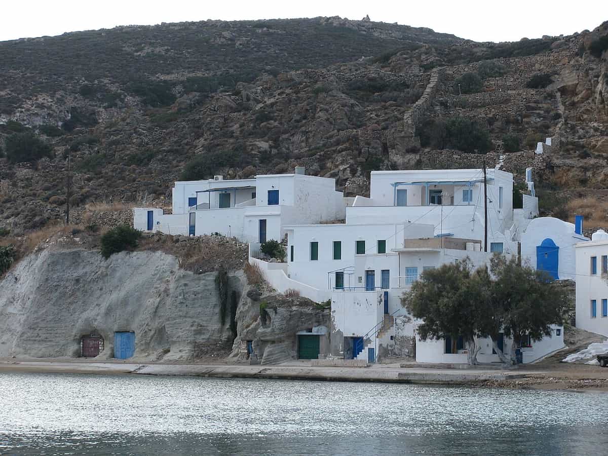
Psathi is a small settlement on the south-east of Kimolos and the main port of the island, 800 metres from Chorio, the capital. The harbour holds fishing boats beside a short beach, and the water inside the mole is calm enough for launching a kayak. Hotels, rooms and cafes stand along the front, together with tavernas that open onto the sand. A paddler reaches the start of the kayak Kimolos route without carrying kit far.
Kimolos sits half a nautical mile north-east of Milos and 1.1 nautical miles south-east of Polyaigos, the uninhabited island that belongs to the same municipality and covers about half the area of Kimolos. From the deck the line of the smaller island reads as a low, pale shape with a hill behind it. The same crossing serves the boat trips from Pollonia, and that passage between the two ports is the shortest way to the kayak Kimolos route.
- Pollonia: the second port of Milos, ten kilometres from Adamas, with a sandy beach and tavernas.
- Channel: one kilometre of water between Milos and Kimolos, with land always in sight.
- Harbour: Psathi, the main port of Kimolos, with fishing boats and a small beach.
- Distance inland: 800 metres from the harbour to Chorio, the capital.
- Start: the beach at Psathi, where the kayak Kimolos route leaves the shore.
Reaching Psathi is the easy part of the day. Pollonia offers a sheltered harbour, a sandy beach and a short crossing, and the two islands sit within sight of each other across a channel one kilometre wide. A paddler arrives at the water with the kit already moved and the boats ready. From that front, the kayak Kimolos route heads out along the coast.


What comes first along the kayak Kimolos route?
The kayak Kimolos route opens with two small, unspoilt and colourful beaches, then the coast changes. The orange-beige rock gives way to vertical brown-black stone, cut by small dark caves that open above the water. The first paddle strokes stay close to the shore.
Two small beaches open at the start, one after the other, both untouched and bright with clean water over pale sand and shingle. The kayak Kimolos route passes them early, when the sea is at its calmest, so a paddler can drift close and read the colours under the hull: turquoise in the shallows, then deep blue where the shelf falls away. The coastline of Kimolos runs for 38 km of bays, small islands and rocky shore.
After the second beach the scenery turns. The orange-beige stone of the opening kilometres gives way to vertical walls of brown-black rock, and the coast grows steeper. Small dark caves appear above the waterline, deep enough to hide a boat from the sun. The change is sudden and marks the middle of the outward leg of the kayak Kimolos route, where the shore stops offering easy landings and starts offering shadow. Paddlers keep a little distance from this wall.
Kimolos belongs to the volcanic arc of the Aegean, and its rocks are mainly acidic volcanic stone. Wide areas of the island lie under tuff, a soft rock that hardens with age. The land carries the marks of that origin: hot springs and a geothermal field, beside landforms cut by wind and water. From the kayak Kimolos route the effect is easy to read, with pale layers low down and dark stone where the sea has worked into the cliff.
The paddling here is quiet work. The line runs close to the shore, where the water is darkest and smoothest, and the swell breaks on the rock. Light from the cliff face falls across the sea in the afternoon, and the small caves read as black marks. Paddlers on the kayak Kimolos route keep their eyes on the stone, because the coast changes faster than a map suggests. A steady rhythm suits this part of the day.
- Opening beaches: two small, unspoilt, colourful beaches with clean water over sand and shingle.
- Rock colour: orange-beige stone that changes to vertical brown-black walls.
- Caves: small dark openings above the waterline, deep enough to give shade.
- Coastline: 38 km of bays, small islands and rocky shore around Kimolos.
- Position: the midway point of the outward leg of the kayak Kimolos route.
This first stretch carries the kayak Kimolos route from bright shallows into shadow. Two beaches hold the eye at the start, and then the wall of brown-black stone closes in, with small caves cut at intervals along it. Landings become harder, so the group keeps moving until the coast opens again. The change of colour is the clearest sign that Katergo lies ahead.
What does the kayak Kimolos route reveal at Katergo?
At Katergo the kayak Kimolos route reaches white geological formations and huge, multicoloured caves. The scenery changes again, with bright rock above the water. A break on the beach follows, for food and swimming, before the return. Rock and cave sit together at this point.
The coast opens at Katergo, and the light changes with it. White geological formations stand above the sea, catching the sun and throwing it back onto the water, so the sea around the boat turns pale. The kayak Kimolos route arrives here after the dark wall of the middle section, and the contrast is immediate: bright stone above, clear water below, and a beach that offers a place to land. Paddlers rest their arms and look up.
The huge caves open in front of the beach, cut into the rock at water level. Their walls carry bands of colour that shift from grey to red and ochre where minerals have stained the stone, and the mouths rise high above the sea. Shadows inside the caves keep the air cool. Nothing else on the kayak Kimolos route matches the scale of these faces, and they close the outward leg.
The stop at Katergo beach gives the group time to eat and swim, with the boats pulled clear of the water. A shallow shelf makes entry easy, and the sand stays warm while the group rests. Paddlers who want more time in the sea can swim towards the cave mouths, keeping the wall in view. Then the kayak Kimolos route turns back, and the coast is read in reverse, cave by cave, cliff by cliff.
From the water the caves form a line of openings along the last part of the outward passage. Light enters the mouths and lifts the colour of the stone inside, and the sea in front of them stays flat and clear. A paddler who stops and holds position can study the faces without landing. The kayak Kimolos route turns at this point, and the day’s middle sits on this bright stretch. The scale is plain from the sea.
- White rock: geological formations above the sea that throw light back onto the water.
- Caves: huge, multicoloured openings at water level, rising high above the sea.
- Break: food and swimming at Katergo beach.
- Landing: a shallow shelf that makes entry easy from the boats.
- Turning point: the furthest point of the kayak Kimolos route before the return.
Katergo is the reason the kayak Kimolos route stays in memory. The white formations above the water and the huge multicoloured caves fill the middle of the day. A landing on the beach splits the paddling, and the swim that follows cools the group before the return. From this point the coast is familiar, and the second half passes more quickly than the first.
What does the return of the kayak Kimolos route show?
The kayak Kimolos route heads back past Psathi, then passes the small Kleftiko of Kimolos and two caves before reaching the beach again. The coast is the same one, seen from the other side. Light falls differently on the return, so the walls and the caves look new.
On the way home the dark wall is on the other side of the boat, and the caves that stood above the waterline now catch the light from a different angle. The kayak Kimolos route passes the two small beaches again, this time with the swell behind and the harbour in view. Psathi appears early, a line of white houses above a short beach, and the boats in the mole mark the position of the finish.
The small Kleftiko of Kimolos stands on this stretch of coast, a pale rock formation with vertical faces. It is a landmark rather than a stop, and the kayak Kimolos route slides past it while the group keeps paddling. The shape is easy to pick out against the sky, and it separates the long brown-black wall from the harbour approach. A camera on the boat catches it well. Nothing about the passage needs a change of course.
Two caves follow, small openings in the rock that mark the last part of the water before Psathi. The kayak Kimolos route passes them close enough to see the dark walls inside and the band of colour at the entrance, where light reaches the stone. Water inside stays still, even when a breeze runs along the coast. After the caves the shoreline flattens, the harbour opens, and the boats come back to the same beach where the day started.
The final stretch into Psathi passes between the mole and the slope of Chorio, with houses above and the beach below. Water here is shallow and warm, and the paddle slows as the boats line up for the landing. Kit is passed up to the sand, the kayaks are lifted clear, and the group steps out where the day began. The kayak Kimolos route closes on that beach. The harbour keeps its calm when the channel outside carries a breeze.
- Return line: the same coast, paddled in the opposite direction.
- Small Kleftiko: a pale rock formation passed on the way back to the harbour.
- Caves: two openings in the rock before the final stretch into Psathi.
- Harbour: the mole and the fishing boats that mark the finish.
- Finish: the beach at Psathi, where the kayak Kimolos route started.
The return gives the kayak Kimolos route a second reading of the same shore. Rock faces that were dark on the way out catch the afternoon light, and the two caves before the harbour sit in shadow. The small Kleftiko marks the last landmark, and after it the water grows calm and shallow near the mole. The trip ends on the sand at Psathi, with boats pulled up and kit stacked.
What is Kimolos like away from the kayak Kimolos route?
The kayak Kimolos route ends on an island named after Kimolos, its first resident in local tradition. Its white rock gave the world the earth once used on blackboards, and Chorio, the capital, sits on a hill above Psathi.
Chorio is the only town on the island, and the official name of the capital, rather than Chora. It grew on a hill in the south-east, with a medieval castle inside. The older quarter gathers around those walls, and museums stand opposite the church of Odigitria and within the castle. A warren of lanes links small squares instead of one large one. The kayak Kimolos route finishes below at Psathi, and Chorio waits a short walk uphill.
The white earth of Kimolos, the kimolian earth, was dug in the past from the rocky land of the southern coast, when the island was still called Argentiera, a name that came from the silver colour of those slopes. It was a valuable trade good, and the island became a trading hub because of it. The stone is soft enough to cut and hardens as it ages, which made it useful for building as well as for cleaning cloth.
Kimolos is a small island, 36 square kilometres in area, with its highest point at Paleokastro and a census population of 810. The shape is close to a regular pentagon, which gives the coast its long line of bays and points. Farming, fishing and the tourist season carry the local economy, and the beaches on the south and east sides stay quiet outside the summer weeks. A paddler on the kayak Kimolos route meets this island from its least crowded side.
- Name: Kimolos, taken from the first resident of the island in local tradition.
- Capital: Chorio, on a hill in the south-east, with a medieval castle.
- White earth: the kimolian earth once used on blackboards, dug from the southern coast.
- Size: 36 square kilometres, with the highest point at Paleokastro.
- Water line: the kayak Kimolos route follows the least crowded side of the island.
The kayak Kimolos route shows the island from the sea, but the land behind it holds the story: a capital on a hill, a castle, museums, white slopes that gave a name to chalk, and a small population that returns to fishing and farming when the season ends. The coast stays quiet, the water stays clear, and the island keeps the size that makes it easy to read.

What do paddlers ask about the kayak Kimolos route?
The kayak Kimolos route covers 8.8 km from Psathi to Katergo and back, with transport, equipment, food and safety included. The coast holds two small beaches, dark rock with small caves, white formations and huge multicoloured caves. Kimolos lies one kilometre from Milos.
What does the kayak Kimolos trip include?
Transport, equipment, food and safety are part of the trip, so a paddler arrives at the water with nothing to organise. Boats, paddles and safety kit travel with the group, and a meal is carried for the stop at Katergo beach. The day stays on the water apart from that break.
Where does the kayak Kimolos route begin?
The kayak Kimolos route begins on the small beach at Psathi, the main port of Kimolos and a settlement 800 metres from Chorio. The harbour holds fishing boats beside the sand, and the water inside the mole stays calm. Tavernas and rooms stand along the front, and the launch takes place straight from the beach.
Which two beaches open the kayak Kimolos route?
Two small beaches lie at the start, both unspoilt and colourful, with clean water over sand and shingle. The kayak Kimolos route passes them before the rock turns dark, so paddlers see the brightest water of the day first. The boats stay afloat, and the shore gives way to the next stage of the coast.
Why does the rock turn dark on the kayak Kimolos route?
The island belongs to the volcanic arc of the Aegean, and its rocks are acidic volcanic stone, with wide areas of tuff that hardens with time. That geology gives Kimolos hot springs, a geothermal field and landforms shaped by the sea, which explains the small dark caves along this part of the coast.
What stands out at Katergo on the kayak Kimolos route?
White geological formations rise above the water at Katergo, and huge multicoloured caves open at sea level in front of the beach. The kayak Kimolos route reaches this point after the dark middle section, so the change in colour is sudden and clear. Swimming and food follow on the sand.
What is the white earth linked to the kayak Kimolos route?
The white earth is the kimolian earth, dug in the past from the rocky southern coast when the island was called Argentiera, after the silver colour of those slopes. It became a valuable trade good. The stone is soft enough to cut, hardens with age, and was used for building and for cleaning cloth.