- Kayak in Milos – Route 1
- Kayak in Milos – Route 2
- Kayak in Milos – Route 3
- Kayak in Milos – Route 4
- Kayak in Milos – Route 5
- Kayak in Milos – Route 6
- Kayak – Route 1
- Kayak – Route 2
Milos is a volcanic island in the Aegean Sea and the south-western island of the Cyclades, and its long shore is made for a paddle. Milos Advisor explains how the coast works, where the water stays calm, and what a day on the sea involves. A kayak in Milos day reaches quiet coves that no road serves.
The island runs about 23 km from north-east to south-west and about 13 km from north to south, and it curves into the shape of a horseshoe around a wide bay. That curve gives paddlers calm water on one side and open sea on the other, and the colour of the rock changes from bay to bay. The west half holds no villages at all.
What is kayak in Milos like along the coast?
A day of kayak in Milos follows a volcanic shoreline of white tuff, dark basalt and sea caves, and the horseshoe shape of the island creates bays that break the wind and give paddlers calm water for long stretches of the route.
The west and south coasts form the wildest part of the island, with no villages and only a handful of small settlements above the water. Hard white tuff, dark basalt and loose volcanic layers stand in vertical walls, and the sea has cut hollows, arches and caves into them over a long period. A kayak in Milos crossing passes those walls at eye level, so the colour bands stay visible the whole way. Sheltered bays open between the headlands.
The coast counts ninety named beaches, seventeen on the north side, twelve on the east, twenty-one on the south, fifteen on the west and twenty-five inside the bay itself. Only part of that shore is reachable by road, and a kayak in Milos route reaches the rest from the water. Volcanic activity began two to three million years ago and stopped ninety thousand years ago, and the island is still classed as a dormant volcano. Every stretch of coast holds its own colour.
Deep water sits close to the cliffs, and a swell that looks small from the road turns into moving water at the base of a wall. The horseshoe shape means one side of the coast is sheltered while the other takes the full force of the wind. Paddlers who read the shape of each bay find flat water behind every headland, and caves along the shore give shade and a break. A kayak in Milos day works with that pattern.
- Coastline: The shore runs in long curves with headlands, small bays and vertical rock along its whole length.
- Volcanic rock: White tuff, dark basalt and loose ash layers give the cliffs banded colours that shift in the light.
- Sea caves: Waves and wind have hollowed arches, tunnels and roofed shelters that a kayak can enter.
- Sheltered bays: The curve of the island keeps flat water on the lee side when the open sea is rough.
- Long sightlines: Low cliffs and clear water let paddlers spot rocks, boats and landing spots from a distance.
A first crossing teaches the pattern of the island quickly. Cliffs, bays and caves repeat along the whole shore, and the water inside each bay behaves in the same calm way. Distances between landing spots stay short on the protected side and longer where the coast opens out. Weather decides the direction of the day, and the land decides how much shelter the group enjoys on a kayak in Milos run.

Which numbered kayak in Milos routes does the island offer?
The six lines of kayak in Milos start at different beaches around the island and pass named coves, caves and rock formations on each crossing, so a paddler picks the stretch of coast that suits the day on the water.
Route one covers 6.6 km and sets off from Gerania beach, keeping close to the shore past more than ten caves with colour in the rock. Near the middle of the crossing the group comes to the wreck of a merchant ship and a hidden cave, and the main break happens at Sarakiniko beach. Part of the group walks with the tour leader to the rock formations above the water while others dive. The kayak in Milos return leg is paddled faster, and the day closes in the Mandrakia area.
Route two covers 6.5 km and begins at Agios Konstantinos beach. The first stop is Alogomantra beach, followed by the traditional village of Agios Konstantinos. Caves and stacked geological formations come next, then the two Pachena beaches, Kapros beach and the caves at Papafragas. A break takes place at the small cave of Papafragas, where part of the group walks around Phylakopi with a tour leader and others swim nearby. The kayak in Milos way back passes the Kanal of Kofto.
Route three runs 6.6 km between Paliochori and Firlingos, and route four 6.0 km past Firiplaka, Tsigrado and Gerakas. Route five covers 8.8 km from Tria Pigadia to Thiorichia, with old sulphur mine workings above the beach. Route six covers 8.8 km and starts from the small beach called Psathi, passing two quiet beaches before the rock turns to vertical brown-black walls with small dark caves. The Katergo area follows, and the return of this kayak in Milos line passes a small Kleftiko.
- Route one: 6.6 km from Gerania beach, past more than ten coloured caves, the merchant shipwreck and Sarakiniko.
- Route two: 6.5 km from Agios Konstantinos beach, past Alogomantra, Pachena, Kapros and Papafragas.
- Route three: 6.6 km on the south coast between Paliochori and Firlingos.
- Route four: 6.0 km past Firiplaka, Tsigrado and Gerakas, with cliff-backed beaches along the way.
- Routes five and six: 8.8 km each, one from Tria Pigadia to Thiorichia and one from Psathi to Katergo.
The six lines cover the whole ring of the island, so the choice of route decides the rock, the exposure and the landing spots. A north coast line keeps the group in the lee of the island when the wind comes from the south, and a south coast line does the same when the air turns northerly. Distances stay between 6.0 km and 8.8 km, which keeps every kayak in Milos crossing inside one session.
How does kayak in Milos reach Kleftiko and its sea caves?
A crossing of kayak in Milos reaches the south-west through Kleftiko, a stretch of white cliffs and islets set in three consecutive coves where wind and sea have opened hollows and caves in the rock over a long period.
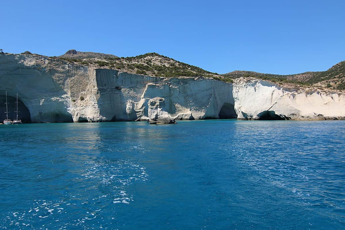
Kleftiko sits in the south-west of the island, and the landscape is built from white cliffs and small islets that stand in the sea across three connected coves. The rock is volcanic, and the sea together with the wind has worn caves into the faces of the cliffs. The whole area is listed as a landscape of special natural value and forms part of a Natura 2000 zone. A kayak in Milos line passes beneath those walls.
The name comes from the era of Mediterranean piracy, when the coves worked as a base for raiders against passing ships, and the caves gave shelter in bad weather. Fishermen report that the caves once served the Mediterranean monk seal as breeding sites, although visitor traffic appears to have pushed the animals away. The rock is tuff in shades from white to dark, built from pumice laid down about 3.1 million years ago, with basalt close by.
A paddle towards Kleftiko follows the south-western coast, where cliffs step back into coves and the water stays deep against the rock. Excursion boats stop at Sykia, a cave on the west coast whose roof has collapsed, letting daylight into the cavern below. The return leg is quicker with the swell behind the boats. A kayak in Milos crossing on this side keeps the group close to the cliffs, and landing spots sit further apart than on the sheltered north coast.
- White cliffs: Tall pale rock faces rise straight from the water and shade the coves through the middle of the day.
- Consecutive coves: Three joined inlets give a series of calm pools to cross one after another.
- Sea caves: Erosion by wind and waves has opened caves that cut deep into the line of the cliff.
- Rock layers: Tuff banded from white and pale yellow to dark, formed from pumice laid down about 3.1 million years ago.
- Protected status: The area is listed as a landscape of special natural value and lies inside a Natura 2000 zone.
The approach to Kleftiko rewards a steady rhythm rather than speed. The cliffs hide the next cove until the bow of the kayak passes the point, and each opening brings a change of light on the water. Boat traffic collects around the main coves in the middle of the day, so an early start gives quieter water and a clearer view into the caves. A pause before each cave lets the group pick the calmest line.

Where does kayak in Milos meet the north coast landmarks?
A route of kayak in Milos on the north coast passes Sarakiniko, Mytakas, Papafragas and Firopotamos, a run of white eroded rock, carved boat garages and sea caves along a shoreline that stays sheltered from the south wind.
Sarakiniko lies on the north shore, about 5 km from Plaka. Waves driven by north winds have shaped the greyish-white rock into rounded forms, and the local landscape is described as lunar. The bone-white colour comes from the erosion of the volcanic rock by wind and waves, and the beach is a small strip of thin white sand between the rock formations, with a couple of trees that give shade at the back. The sandy part measures 10 metres.
The west side of Sarakiniko holds the pale rock, while the east side turns into dry ground with low plants and rough stone. A wrecked ship named Africa lies on that eastern side after running aground in 2003, and the hull becomes visible when the waves pull back. Erosion along the coast has also opened caves, and Saracen pirates once sheltered inside them, which gave the beach its name. A kayak in Milos crossing sees the hull from the water.
Mytakas, Papafragas and Firopotamos continue the same north coast. Papafragas gives its name to a thick layer of volcanic material that deepens towards the east, with caves cut into soft pale rock. Firopotamos is a settlement where boat garages called syrmata are carved into volcanic tuff beside the sea, and the same shelter appears at Klima and Mandrakia. Whether a kayak in Milos day reaches these beaches by beaches of Milos on land or by paddle, the coast stays within reach.
- Sarakiniko: White eroded rock, a 10 metre sandy strip and caves that took their name from Saracen pirates.
- Shipwreck: The hull of a vessel that ran aground on the eastern side in 2003 shows when the waves fall back.
- Mytakas: A north coast beach on the same sheltered line, with pale rock above clear water.
- Papafragas: Caves in soft pale rock, named after a volcanic layer that thickens towards the east.
- Firopotamos: A settlement of syrmata, painted boat garages cut into volcanic tuff beside the water.
The north coast works well for a shorter day on the water. Headlands break the swell, the beaches sit close together and the rock stays pale and open, so the group sees a long way ahead. Wind from the north drives the waves along the shoreline, which makes direction and timing important. When the air turns southerly, this side of Milos turns flat and the whole kayak in Milos landmark run becomes an easy crossing.
Can kayak in Milos include snorkelling and swimming stops?
A day of kayak in Milos includes snorkelling and swimming stops, because the routes break at named beaches such as Sarakiniko, Papafragas and Katergo, where the water stays clear over rock and sand for the whole group on the water.
Each numbered route contains a rest on shore. Route one breaks at Sarakiniko beach, and part of the group dives to look at the seabed while the rest walk to the rock formations above. Route two pauses at the small cave of Papafragas, where the water inside and the pool outside give an easy place to swim. Route six stops for food at Katergo. The pattern holds on every kayak in Milos crossing, so a paddle and a swim share one day.
The clarity comes from the volcanic ground and the absence of river silt along this coast. Rock, sand and pebble sit close to the surface in the bays, and shallow shelves near the caves hold colour at the depth a snorkel reaches. Deep water begins close to the cliffs in places, so the edge of a bay marks a natural boundary between a swim and the open sea. A kayak in Milos route takes its combined activities the same way.
A swimming stop also serves the group. Body temperature drops during a long paddle, and a short spell in the water restores the arms and shoulders. Sun screen, a hat and a spare layer sit in the dry bag, and the kayaks stay pulled onto the beach or held in shallow water. The break lets the tour leader read the sky, the swell and the wind before the group commits to the way back, keeping a kayak in Milos day flexible.
- Shore breaks: Every numbered route includes a stop on land at a named beach or cave.
- Clear water: Volcanic ground and no river silt keep the bays bright over rock, sand and pebble.
- Snorkel depths: Shallow shelves near the caves sit within easy reach of a mask and snorkel.
- Rest and recovery: A short swim eases the shoulders before the return leg of the crossing.
- Weather check: The break lets the tour leader read wind, sky and swell before the group turns back.
Water, shade and rest matter as much as the paddle itself. The rock at Sarakiniko and Kleftiko holds heat through the middle of the day, and a bay with a cave mouth nearby gives cooler air. Snorkelling fits between the two halves of a crossing, so the group swims when the arms are fresh and the light is still high over the bay. Guests then climb back into the kayaks and finish the route.

When is the best time for kayak in Milos and the meltemi?
The season of kayak in Milos meets the meltemi in summer, a dry north wind that blows across the Aegean from late spring to early autumn and decides the direction of every route, at times reaching force 7 to 8 on the Beaufort scale.
The etesian winds, known in Greek as the meltemia, are the strong dry north winds of the Aegean. They blow in a periodic pattern from late spring to early autumn, covering four months, and count as the dominant influence in the Aegean basin. The wind reaches its greatest strength in the afternoon and falls away at night, though it holds for days without a break. It comes up in clear weather without warning and reaches force 7 to 8 on the Beaufort scale.
The direction of the meltemi shifts with latitude. In the northern Aegean it blows from the north-east to the north, in the central Aegean it blows from the north, and in the southern Aegean, including the Cretan and Carpathian seas, it turns north-westerly. Milos sits at the southern edge of the Cyclades, so the local wind arrives from the north or the north-west. Milos has a Mediterranean climate with mild, rainy winters and warm to hot dry summers.
On the water, the daily rhythm of the wind matters as much as the season. Air is light after dawn, builds through the morning and peaks in the afternoon, then drops after sunset. A route that runs north in the morning and returns south in the afternoon works with that pattern, while a crossing that beats against the wind becomes hard work. Away from the meltemi season the Aegean turns calmer, and a kayak in Milos day rests on the forecast.
- Season: The meltemi blows from late spring to early autumn and shapes the whole summer on the water.
- Time of day: The wind strengthens in the afternoon and falls away at night, so mornings stay calmer.
- Force: The wind comes up in clear weather without warning and reaches force 7 to 8 on the Beaufort scale.
- Direction: North to north-east in the northern Aegean, north in the centre, north-west in the south.
- Climate: Milos has mild, rainy winters and warm to hot dry summers under a Mediterranean pattern.
Planning around the meltemi is straightforward once the pattern is clear. Wind from the north favours the south coast, and wind from the south favours the north coast, so the choice of kayak in Milos route follows the forecast each morning. The window after dawn holds the lightest air, and a break at midday puts the group on shore while the wind peaks. Sea state follows the wind, and the water stays flat in the lee of the headlands.
What safety and gear does kayak in Milos require?
A day of kayak in Milos requires safety cover, working gear and a check on the weather, and every one of the six published routes includes transport, equipment, food and safety as part of the arrangement for the group on the water.
Equipment and safety come with the route. The published lines list transport, equipment, food and safety as part of the arrangement, and the same four items appear on each of the six crossings. A life jacket stays on the body for the whole time on the water, and the group leaves the beach only when everyone is wearing one. The tour leader carries a first aid kit, a repair kit and a way of calling for help.
Water, food and sun protection matter on a hot day. The Aegean summer is dry and bright, the rock reflects light back onto the water, and the sea adds further glare. A wide hat, a long-sleeved layer and high-factor sun screen sit on top of the water and food carried in the kayak, and every kayak in Milos group drinks before thirst arrives, because the breeze off the sea hides dehydration. A dry bag holds a spare layer and a phone.
Beginners fit into the same structure. A kayak in Milos crossing runs between 6.0 km and 8.8 km, and the pace follows the slowest boat, so a first-time paddler holds the same line. The tour leader shows the basic stroke, the way to turn the boat and the way to enter and leave the water, and the middle break gives a natural pause. Anyone who can swim and follow simple instructions can join a calm crossing.
- Life jackets: A jacket stays on the body from the beach to the landing at the end of the route.
- Group equipment: Transport, equipment, food and safety come with every one of the six published routes.
- Water and food: Drinks and a snack travel in the kayak, because the sea breeze hides thirst on a hot day.
- Sun cover: A hat, a long-sleeved layer and high-factor screen answer the glare from rock and water.
- Beginners: A slow group pace and a short skills briefing let a first-time paddler join a calm crossing.
A calm head and a simple routine carry a group through a long day on the water. Gear is checked before the boats leave the beach, the forecast is read again at the break, and the group stays together within sight of the tour leader on every leg of the kayak in Milos route. Anyone who tires sits in the middle of the line, and the leader adjusts the pace without changing the plan.
What do people ask about kayak in Milos?
Planning for kayak in Milos raises practical questions about level, timing, gear and weather, and the answers depend on the route, the forecast and the experience of the group on the water that day, and a short briefing covers the rest.
Is kayak in Milos suitable for beginners?
A beginner can enjoy kayak in Milos in calm conditions. The group moves at the pace of the slowest boat, and the six published routes run between 6.0 km and 8.8 km. A tour leader explains the stroke and the turn, and swimming ability matters more than earlier time in a kayak.
What gear does kayak in Milos require?
A place on a kayak in Milos route comes with equipment, transport, food and safety. A life jacket stays on the body for the whole crossing, and the group carries water, a snack, a hat and sun screen. The tour leader carries a first aid kit and a repair kit, and the boats hold a paddle for each seat.
When does the meltemi affect kayak in Milos?
The meltemi reaches kayak in Milos from late spring to early autumn, across roughly four months of the year. The dry north wind strengthens through the afternoon and falls away at night, arriving in clear weather without warning. It reaches force 7 to 8 on the Beaufort scale, far beyond paddling. Mornings hold the lightest air.
Where do the kayak in Milos routes start?
The kayak in Milos routes start at named beaches around the island. Route one leaves from Gerania beach, route two from Agios Konstantinos beach, and route six from the small beach called Psathi. Route three runs between Paliochori and Firlingos, route four passes Firiplaka, Tsigrado and Gerakas, and route five runs from Tria Pigadia to Thiorichia.
Can kayak in Milos reach Kleftiko?
A kayak in Milos route reaches Kleftiko on the south-western coast, where white cliffs and islets stand in three consecutive coves. Erosion by wind and sea has opened caves in the rock, and the area forms part of a Natura 2000 zone. The return leg runs faster with the swell behind the boats, and landing spots sit further apart here.
Is snorkelling part of kayak in Milos trips?
A kayak in Milos trip builds a swim into every route. Route one breaks at Sarakiniko beach, route two pauses at the small cave of Papafragas, and route six stops at Katergo. Volcanic ground and the absence of river silt keep the bays bright, and shallow shelves near the caves sit within reach of a snorkel.
What happens if the wind rises during kayak in Milos?
A kayak in Milos day stays inside the sheltered band of the coastline when the wind rises. The break in the middle of each route gives the tour leader a chance to read the sky, the swell and the wind before the group commits to the way back. A north coast route works when the air turns southerly.