
A Polyaigos boat trip sails from the island of Milos to a large island where nobody lives. Polyaigos has bare volcanic hills, beaches and sea caves along a long coast. Water surrounds it on every side, so boats carry every visitor from the nearby harbours to its shore.
Polyaigos lies east of Milos and south-east of Kimolos, in the south-west corner of the Cyclades. It covers about 18 square kilometres, which is half the size of Kimolos. A Polyaigos boat trip shows its coast from the sea, where hills, bays and caves meet the water.
What is a Polyaigos boat trip, and why does it need a boat?
A Polyaigos boat trip is a day at sea around Polyaigos, an island east of Milos. Nobody lives on the island, which is why it is called uninhabited. Open water separates it from Milos and Kimolos, so boats carry every visitor to its coast.
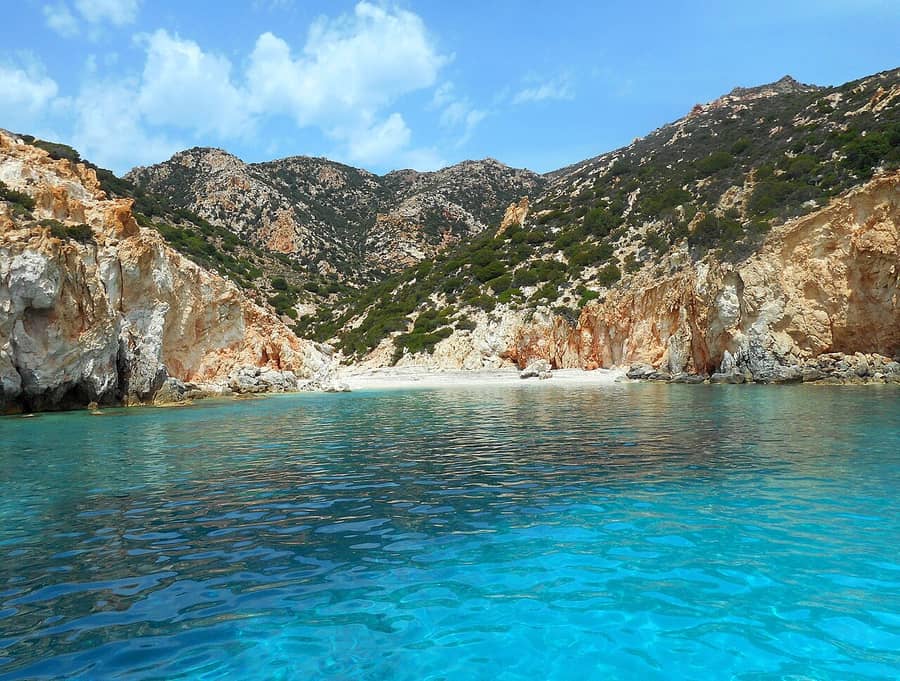
Aegean Sea waters hold the Cyclades, a group of islands south-east of the Greek mainland. Polyaigos is one of them, together with its neighbours Milos and Kimolos. Of the three islands, only Milos and Kimolos have residents.
Kimolos is the nearest land, 2 kilometres to the north-west of Polyaigos. Milos lies 6.2 kilometres to the west. Both gaps are open sea, and a boat must cross one of them before anyone sees the coast.
Nobody lives on Polyaigos, so the island has no town of its own. Every Polyaigos boat trip therefore starts on another island nearby. Tourist tours reach Polyaigos on private boats, either ordinary boats or fast speedboats.
From the deck, the island shows hills of volcanic rock. Volcanic rock forms when a volcano pours out lava or ash. Milos and Kimolos are made of the same kind of stone, so the three islands look alike.
Beaches lie mainly on the south side of the island. Sea caves line the shore and shelter the Mediterranean monk seal, a rare animal. The coast runs for 22 to 27 kilometres, so a Polyaigos boat trip passes a long shore.
Polyaigos is the largest uninhabited island in the Aegean Sea. Goats graze its slopes and keep the land bare. A Polyaigos boat trip shows the island as it is, without a single village on it.
- Municipality: Polyaigos belongs to the municipality of Kimolos, not to Milos.
- Neighbours: Agios Efstathios and Agios Georgios are two small uninhabited islands in the same municipality.
- Name: The Greek name means a great number of goats.
- Spellings: Polyaegos and Polivo are other spellings used for the same island.
- Other names: Polyvos and Nipolyvos are modern Greek names for the island.
In short, a Polyaigos boat trip is a sea day to a large island with no residents. Boats carry every visitor, and the coast is the main sight. The next section describes the island itself, from its size to its highest hill.

What is the island like on a Polyaigos boat trip?
A Polyaigos boat trip visits an island of about 18 square kilometres, with hills up to 370 metres. Its rock is volcanic, its land is bare, and goats graze its slopes. Nobody lives there all year round, so the island stays empty.
Polyaigos is about 6 kilometres long at its longest point. At its narrowest, it measures 4.3 kilometres across. The two numbers describe a compact block of land on the map, not a thin strip of rock.
Two hills mark the skyline of the island. Psilo Vouno is the higher one, at 370 metres, and Stroggylo is lower, at 330 metres. Both hills are visible from the water on a Polyaigos boat trip.
The land is dry, and goats keep it barren. Good harbours exist only on the west coast, where a Polyaigos boat trip can shelter. A harbour is a sheltered bay where boats can stay safe from waves.
Long ago, people reported that 170 residents lived on Polyaigos. By 1951, only 14 residents remained on the island. The census of 2011 counted two herders, a couple, and now nobody lives there all year round.
The land of Polyaigos serves mainly as pasture, meaning open ground where animals graze. A church trust owns about 90 percent of the island, which is nearly all of it. Herders from Milos and Kimolos rent parts of the island for their goats.
Milos and Kimolos once argued over who owned the island. Judges from Argos, a city on the mainland, settled the case. They gave Polyaigos to Kimolos soon after 338 BC, and Kimolos still holds it today.
- Crossroads: The island sits where sea routes of the Aegean cross.
- Islets: Manolonisi is an islet by the west coast, and the Kalogeroi islets are by the south coast.
- Quarries: Two old quarries in the north-west cut trachyte, a volcanic stone used for millstones.
- Lighthouse: A lighthouse stands on Cape Maskoula, 138 metres above the sea, on the east side.
- Wider view: Sifnos lies to the north-east and Folegandros to the south-east.
A Polyaigos boat trip therefore shows an island that is large, dry and bare. Its hills, its volcanic stone and its sheltered west bays all show from the sea. A Milos catamaran cruise that adds the island to its route is one way to see them.
Where does a Polyaigos boat trip start?
A Polyaigos boat trip starts at a port on Milos or on Kimolos. Boats leave from Pollonia and Adamas on Milos, and private boats sail from Kimolos. The island has no residents, so every trip is a sea crossing.
Polyaigos is an uninhabited island in the Cyclades, next to Milos and Kimolos. It lies 2 kilometres south-east of Kimolos. Milos is to the west, and it is farther away than Kimolos. These two islands are the starting points.
Pollonia sits at the north-eastern tip of Milos, in a seaside village. Only Adamas ranks ahead of it as a harbour. Kimolos lies north-east of Milos. A Polyaigos boat trip from the village of Pollonia therefore starts on the side nearest to Kimolos.
Adamas is the first port of Milos, and boats for sea excursions leave from it as well. A sailing yacht sets out from Adamas or Pollonia to cover the coastline of Milos, Polyaigos and Kimolos. Both ports therefore serve a Polyaigos boat trip.
Kimolos has its own trips. Tourist trips to Polyaigos run from there on private boats, either ordinary boats or speedboats. A Polyaigos boat trip from Kimolos has the shortest crossing. Only 2 kilometres of sea separate the two islands.
Sifnos lies farther away, 8.8 nautical miles north-east of Polyaigos. Nautical miles are the distance unit used at sea. The gap from Kimolos is only 2 kilometres. That sea is far narrower than the one between the island and Sifnos.
- Pollonia: A small boat links the village with Kimolos.
- Beach: The main beach of Pollonia is sandy.
- Adamas: The port also appears as Adamantas on maps.
- Psathi: The harbour of Kimolos has small boat houses.
- Municipality: Polyaigos belongs to the municipality of Kimolos.
In short, a Polyaigos boat trip begins at Pollonia or Adamas on Milos, or on Kimolos. Every start leads to the same uninhabited island with its bays. The bays and beaches that these boats visit are named in the next section.

Which beaches does a Polyaigos boat trip reach?
A Polyaigos boat trip offers four named beaches: Panagia, Pano Mersini, Kato Mersini and Ammoura. The Mersini pair is the upper and the lower beach. Ammoura is also called the Lighthouse beach, and the island has had a lighthouse since 1898.
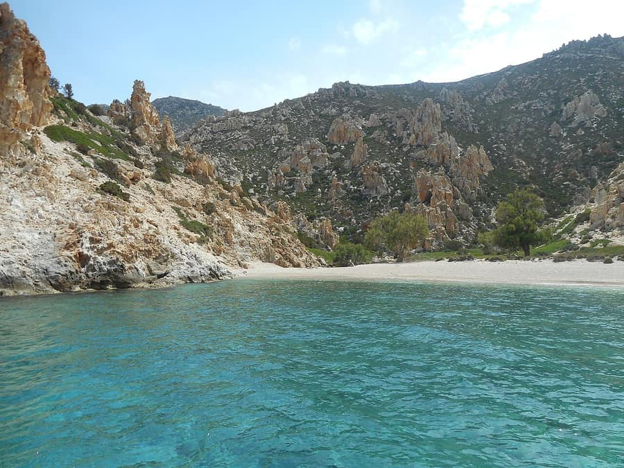
The Mersini pair needs a note on spelling. Mersini is also written Myrsini, and both forms are in use. Pano Mersini is the upper beach, and Kato Mersini is the lower beach. One name therefore covers two beaches.
Pano Mersini has two small coves that work as safe anchorages. In plain words, a boat can drop anchor there and stay safe. On a Polyaigos boat trip, such a cove is a place to stop in shelter.
People also left traces at Pano Mersini. A large amount of obsidian, flint and pottery was found there. Obsidian is a hard black volcanic glass, and flint is a hard stone that breaks into sharp edges. The finds date from prehistoric to Byzantine times, so the spot was in use for centuries.
Ammoura is the fourth beach, and it has a second name, the Lighthouse beach. The second name points to the island lighthouse, which has stood on the island since 1898. On a Polyaigos boat trip, a call at Ammoura reaches a place named after that light.
The Kalogeroi are an uninhabited rocky islet south of Polyaigos. Its water is a deep, bright blue. The sand on the seabed is as white as chalk. The islet is part of Kimolos, like Polyaigos itself.
Manolonisi is another uninhabited rocky islet, this one west of Polyaigos. The people of Kimolos call it Manolis’s island. It counts among the well-protected anchorages of the area. The bay of Pollonia, Voudia and Psathi are on the same list.
- Land: Goats graze the land and keep the island barren.
- Access: A day cruise from Pollonia visits beaches that cannot be reached by road.
- Picnic: The same cruise stops for a picnic under tamarisk trees on a beach.
- Chalk: Kimolia, the Greek word for chalk, comes from the name of Kimolos.
- Lighthouse: It stands on Cape Maskoula, 138 metres above the sea.
In short, the beaches of Polyaigos are Panagia, the two Mersini beaches and Ammoura. The Kalogeroi and Manolonisi add islets with blue water and safe anchorages. A Polyaigos boat trip meets bare land, sheltered coves and bright water. The next section sets out the kinds of day at sea.
What does a half-day, full-day or sunset Polyaigos boat trip cover?
A Polyaigos boat trip covers more places as the day grows longer. A half-day trip keeps to one island. A full day adds a beach picnic and Kleftiko. A sunset trip ends with the evening light over the sea.
A half-day Polyaigos boat trip is the short version of the day. Polyaigos lies only 2 kilometres from Kimolos. One island and one swim stop therefore fit into a shorter day. Kleftiko appears on the longer routes.
Day cruises from Pollonia give a full day at sea. They sail to the islands of Polyaigos or Kimolos. The day is made of swimming in crystal-clear water and picnicking. A full-day Polyaigos boat trip from Pollonia is built from these two parts.
Other destinations can be chosen, such as Kleftiko. A day cruise from Adamas shows the same pattern. It follows the west side of Milos to Kleftiko, where passengers dive off the boat and the rocks. After that comes a cave tour by inflatable boat.
A sailing yacht covers the coastline of Milos, Polyaigos and Kimolos in one trip. It adds a snorkeling trip, which means swimming with a mask to look at the sea floor. It also adds a cave tour at Kleftiko by inflatable boat.
A sunset Polyaigos boat trip ends with the evening light. One day cruise from Pollonia stops for the sunset at Glaronissia, with ouzo and mezedes. Ouzo is a Greek spirit, and mezedes are small plates to share.
On the Adamas route, the sunset comes on the final stretch home, with coffee under open sails. A night sail under the stars is also possible, and so is a full-moon sail. Longer cruises spend more days at sea.
- Half-day: One island and one swim stop.
- Full day: Swims, a picnic and a stop at Kleftiko.
- Sunset: The evening light, with a stop at Glaronissia.
- Night: A night sail or a full-moon sail under the stars.
- Longer: Cruises that spend more days at sea.
In short, the kind of day sets the number of stops, not the island. A short day trims the list, a full day grows it, and a sunset stop closes it. Every Polyaigos boat trip still crosses to the same uninhabited island.

Which animals are part of a Polyaigos boat trip?
A Polyaigos boat trip passes an island where goats are the only residents. The island is protected for Eleonora’s falcon, a bird of coastal cliffs. The goats keep the island barren, and herders rent parts of the land.
Goats are the island’s only residents, and Polyaigos has no village. Even its Greek name points to goats. A Polyaigos boat trip sails past the pasture where these herds graze, on an island without permanent people.
A fund linked to a church owns about 90 percent of Polyaigos. It rents parts of the land to herders from the nearby islands of Milos and Kimolos. The island serves mainly as pasture, so the herders keep their goats there.
The goats shape the whole landscape. Their grazing keeps Polyaigos barren, which means the land carries very little plant life. On a Polyaigos boat trip, this is why the slopes look bare rather than green from the water.
Eleonora’s falcon is the bird behind the island’s protected status. It is a medium-sized falcon, 36 to 42 cm long, with long pointed wings and a slim body. Two-thirds of the species breeds on islands off Greece.
The species nests in colonies on coastal cliffs, laying up to four eggs. It breeds late in summer, because small birds on migration cross the Mediterranean islands then. It hunts these migrants in flight, using speed and acrobatic flying.
Eleonora’s falcon, the species behind the island’s listing, is a long-distance migrant. It spends the winter in Madagascar, flying there by an inland route through the Sahara Desert. Satellite tracking shows that a single one-way trip has covered up to 9,000 km.
- Goats: Herds graze the island and keep it barren.
- Falcon: Eleonora’s falcon nests on coastal cliffs.
- Migrants: The falcon hunts small birds that cross the islands.
- Seals: Sea caves on Polyaigos serve as a refuge for monk seals.
- Herders: They come from Milos and Kimolos.
Together, these animals describe the island: grazed land, coastal cliffs and open sea. A Polyaigos boat trip shows that setting from the water. The falcon is also why the island sits inside a protected area, as the next section explains.
Which nature rules apply on a Polyaigos boat trip?
A Polyaigos boat trip visits an island inside the European Union’s Natura 2000 network. For Eleonora’s falcon, Greece lists Polyaigos as a Special Protection Area. The network does not ban visitors, but tourism must not harm the nature it protects.
Natura 2000 is a network of nature protection areas across the European Union. It covers both land and sea areas. Two EU laws create it, one from 1979 for birds and one from 1992 for habitats.
The two laws set up two kinds of areas: Special Protection Areas are for birds. Special Areas of Conservation cover other species and habitat types, such as particular forests, grasslands or wetlands. Together, the two kinds of area form the network.
Polyaigos belongs to the Natura 2000 network, where Greece listed it as a Special Protection Area. The species named for protection is Eleonora’s falcon, a bird that nests on coastal cliffs. The listing treats the island as an important habitat that human presence leaves undisturbed.
Natura 2000 does not close an area to people. Sites differ widely: wilder places sit beside farmed and forested ones. Even towns can lie inside the network, and the rules differ from site to site.
Farming, hunting and tourism can continue inside a Natura area. They are allowed as long as they do not harm what the area protects. A Polyaigos boat trip counts as tourism, so the same condition applies.
No single list of banned actions exists for these areas. The rules depend on studies of each area and its needs. On a Polyaigos boat trip, the practical idea is to avoid disturbance of the cliffs and caves.
- Network: Natura 2000 links protected nature areas across the European Union.
- Birds: Special Protection Areas are set up to protect birds.
- Status: Polyaigos is listed for Eleonora’s falcon.
- Tourism: Visits are allowed when they do not harm nature.
- Caves: Shy seals avoid people, and careless diving trips scare them from their caves.
Protected status on Polyaigos means careful visiting, not no visiting at all. Visitors who leave sea caves undisturbed follow the spirit of the protection. Each Polyaigos boat trip fits that idea when it harms neither the cliffs nor the sea caves.
Can a Polyaigos boat trip include Kimolos on the same day?
A Polyaigos boat trip can include Kimolos, because the two islands lie only about 2 km apart. Both belong to the municipality of Kimolos. Polyaigos is the uninhabited island of goats, and Kimolos is the inhabited island to its northwest.
Kimolos lies about 2 km northwest of Polyaigos, and Milos lies 6.2 km to its west. So a Polyaigos boat trip from Milos can reach both islands. Polyaigos is about half the size of Kimolos, which has 36 square kilometres.
The west coast is the sheltered side of Polyaigos. Only the west coast has good harbours, so a Polyaigos boat trip finds shelter on that side. Two small bays at Pano Mersini shelter boats, and finds there date from prehistoric to Byzantine times.
Four rock islets lie between Milos and Polyaigos: Kasseles, Agios Georgios, Manolonisi and Agios Efstathios. Agios Georgios and Agios Efstathios belong to the municipality of Kimolos, like Polyaigos. Manolonisi lies off the west coast of Polyaigos itself.
On Kimolos, Psathi is the port, and Chorio is the main village, on a hill in the southeast. Anyone going ashore can plan getting around Kimolos in advance. Vehicles of all kinds are allowed, and buses and taxis serve popular beaches.
The municipality of Kimolos covers more than the main island. It also includes Polyaigos, Agios Efstathios and Agios Georgios, which are all uninhabited. Its total land area is about 53 square kilometres, and Polyaigos covers about 18 of them.
Polyaigos is 6 km long at its longest, and its coast runs 22 to 27 km. A Polyaigos boat trip around the island covers a long shoreline. The short hop to Kimolos then adds a port and a village to the day.
- Pano Mersini: Two small bays on the west coast form safe anchorages.
- Cape Maskoula: A lighthouse stands here on the east side.
- Kalogeroi: These islets lie off the south coast.
- Manolonisi: This islet lies off the west side of Polyaigos.
- Agios Efstathios: This islet lies between Milos and Polyaigos.
In short, a day that links the two islands stays within a small area. Polyaigos supplies the sheltered bays and the open coast, and Kimolos supplies the port and the villages. The islands are close enough that a Polyaigos boat trip can end at Kimolos.

Which boats make a Polyaigos boat trip?
A Polyaigos boat trip uses four kinds of boat. These are traditional wooden boats, small speedboats, catamarans and sailing yachts. Each one feels different on the open water east of Milos. The boat sets the speed, the room on deck and the rocking.
Polyaigos lies 6.2 kilometres east of Milos. It is 2 kilometres from Kimolos. Nobody lives on the island, so the boat is both the way in and the only base. On a Polyaigos boat trip, the boat shapes the visit.
A caïque, called a kaiki in Greek, is a traditional wooden boat of the Aegean. Pine wood is a common choice for the hull. A white coat of paint turns back the powerful sun. Fishermen once worked from it, and now it carries visitors. On a Polyaigos boat trip, it gives an old Aegean feel.
A speedboat is a motorboat with a much higher cruising speed. Its V-shaped hull helps it cut through the water. The same hull steadies it in rough sea. On a Polyaigos boat trip, a small speedboat crosses the gap fast. Look at a Milos private boat tour for more boat types.
A catamaran rides on two parallel hulls of the same size. Their wide spacing resists rolling and overturning. It also reduces the motion that waves cause. On a Polyaigos boat trip, that gives a steadier deck. It helps anyone who dislikes a rocking boat.
A yacht is a boat made for pleasure, cruising or racing. A sailing yacht is pushed partly or fully by its sails. Its pace therefore follows the wind. On a Polyaigos boat trip, it suits people who enjoy the sea more than speed.
- Wooden boat: A white hull and bright colours give an old Aegean feel.
- Speedboat: A V-shaped hull cuts the water fast and steadies the ride.
- Catamaran: Two hulls resist rolling and reduce wave motion.
- Sailing yacht: Sails push the boat, so the pace follows the wind.
- Distance: Polyaigos lies 6.2 kilometres east of Milos.
Each boat gives a Polyaigos boat trip its own pace. The wooden boat feels traditional, and the speedboat is quick. The catamaran stays steady, and the yacht follows the wind. All four cross the same narrow water between the islands. The next section describes it.

How does the sea between three islands feel on a Polyaigos boat trip?
A Polyaigos boat trip happens in narrow water between Milos, Kimolos and Polyaigos. The Ammoni strait, which separates Milos and Kimolos, is only 1 kilometre wide. The Pyrgi strait lies between Kimolos and Polyaigos. The summer meltemi wind decides how rough the waves feel.
Milos, Kimolos and Polyaigos form one island group. In the Cyclades, it occupies the south-western end. The group sits at an important crossroads of the Aegean Sea. Kimolos lies north-east of Milos. A channel only 1 kilometre wide, the Ammoni strait, separates the two.
Polyaigos lies south-east of Kimolos, 2 kilometres away. The sea passage between the two islands is the Pyrgi strait. Four rocky islets lie between Milos and Polyaigos. The four are Kasseles, Agios Georgios, Manolonisi and Agios Efstathios. Pyrgi is another name for Agios Efstathios, which has a lighthouse. Its light serves boats in the passage.
The meltemi is a strong, dry wind that blows from the north across the Aegean Sea. Its season lasts from late spring to mid-September. It is strongest in the afternoon. It tends to die down at night. Once it starts, it can run for days without stopping.
On a meltemi day, the sky stays clear but the sea turns wavy. Clear weather gives no warning before the wind rises. Its strength can climb to force 7 or 8, measured on the Beaufort scale. That scale links wind speed to conditions at sea. On those days, a Polyaigos boat trip meets a wavy sea.
Strong meltemi days can stop small boat trips, above all by day. Not every yacht can sail in such wind. Leisure sailors still value it, because it gives a good, steady push. The page about a Milos sailing tour explains how sails use that push.
- Ammoni strait: The channel that separates Milos from Kimolos measures only 1 kilometre across.
- Pyrgi strait: A lighthouse on a small islet serves the passage.
- Season: This wind is active from late spring until mid-September.
- Strength: Wind force can rise to 7 or 8 on the Beaufort scale.
- Sea state: The sky stays clear while the sea turns wavy.
The narrow water between the three islands is calm or lively, and the wind decides which. A Polyaigos boat trip in a light wind feels easy. A meltemi day brings a wavy sea. The next section covers what to carry to the island itself.
What does a visitor pack for a Polyaigos boat trip to an island with nothing on it?
A Polyaigos boat trip reaches an island with no village, no shop and no water supply. Everything has to come on the boat. That means water, a hat, sun cream, swimwear, a towel, soft shoes and a litter bag.
Polyaigos is an uninhabited island of the Cyclades. Its name means a great number of goats. The goats keep the land barren. Nobody lives there, so no village, shop or café waits at the shore. A Polyaigos boat trip depends on what the boat carries.
The island is dry and has no water supply of its own. Drinking water therefore comes from the boat or from the bag. The summer heat of the region can be fierce. Each person needs a full bottle.
Goats graze the island bare, so the land gives little shade. A hat covers the head, and sun cream protects the skin. Light clothes with long sleeves help too. On a Polyaigos boat trip, the sun is the main weather to plan for.
Beaches lie mainly along the southern shore. The coast also has sea caves. Swimwear and a towel suit those shores. The island is made mainly of volcanic rock. Soft shoes protect the feet on the shore.
Greece protects Polyaigos in the Natura 2000 network. The Mediterranean monk seal gives birth on the island. Eleonora’s falcon is a protected bird there. So every wrapper and bottle goes into a litter bag. All of it leaves with the boat.
- Water: Drinking water comes on the boat, because the island is dry.
- Hat and sun cream: Both guard against summer heat on land with little shade.
- Swimwear and towel: They suit the beaches on the southern side.
- Soft shoes: Volcanic rock covers the island, so soft shoes protect the feet.
- Litter bag: Every item carried to the island leaves with the boat.
A Polyaigos boat trip works best with a full bag on arrival and an empty beach on leaving. Water, sun cover, swim gear and a litter bag cover the basics. The island has no village, no shop and no water supply.
Is a Polyaigos boat trip a good first boat day for families?
A Polyaigos boat trip suits a first boat day. The island lies close to Milos and Kimolos, so the crossing is short. The west coast has safe anchorages. A covered deck and fitted life jackets keep children and adults comfortable.
The gap to Kimolos measures 2 kilometres. The gap to Milos measures 6.2 kilometres. Both are short for open water. A Polyaigos boat trip spends less of the day crossing. More of it goes to swimming in a bay and looking at the coast.
On the west side, two small coves at Pano Mersini form safe anchorages. A boat can rest there, away from the open sea. A sheltered stop matters for anyone nervous on the water for the first time.
South of Polyaigos, the Kalogeroi islets have blue water over white sand. White sand makes the seabed easy to spot, which calms a nervous swimmer. Families who want a swim-focused day also look at a Milos snorkeling cruise.
Shade matters on a first boat day, and time ashore offers little relief. The boat has to provide it. Families check the tour description for a covered deck or a canopy. They also look for a place to sit out of the sun.
A life jacket keeps a swimmer’s head and mouth above the water with no effort. It also lets a child who cannot swim enter the water safely. Life jackets come in sizes for different body weights, and special models suit children.
- Life jackets: A loose jacket gives less lift, so each child tries one on first.
- Shade: The description names a canopy or a covered deck.
- Safe bays: The route includes a sheltered stop, such as Pano Mersini.
- Boarding: An adult keeps one hand ready for each young child on the steps.
- Seat: A seat near the middle of the boat feels steadier for anyone who gets seasick.
A Polyaigos boat trip goes best on a first outing when the plan stays simple. One sheltered bay, a clear shade plan and a life jacket for every child cover the main points. Longer routes and extra stops can wait.
How does a traveler choose a Polyaigos boat trip?
A Polyaigos boat trip comes down to four choices. These are shared or private, half day or full day, the start harbour and the tour description. Each choice changes the pace of the day, so travelers match all four to their group.
A shared boat follows a set route with other travelers. The crew fixes the stops. A private boat belongs to one group for the outing. That group sets the pace with the crew, which suits travelers with their own ideas for swim stops.
A half day suits first-timers and families, because it keeps the plan light. A full day suits keen swimmers who want to reach more bays. The right pick depends on how long the group enjoys the water.
Boat trips on Milos leave from two ports, Adamas and Pollonia. Adamas is the island’s harbour town. Pollonia lies in the north-east, on the side that faces Kimolos. A traveler picks the harbour closest to where the group stays.
Group size shapes the day. A small group means less waiting at each swim stop. A larger group brings more company and a bigger boat. The tour description gives the number of passengers, so the traveler can compare trips.
The tour description is the only plan a traveler sees before a Polyaigos boat trip. A vague one is hard to compare. A clear one gives the same facts every time. These are the boat, the route, the stops and what is on board.
- Boat: The kind of boat and its group size are named.
- Route: The bays on the route are listed by name.
- Stops: The text says whether the boat anchors for swimming or lands passengers.
- On board: Shade, life jackets and a toilet are listed.
- Harbour: The start harbour and the meeting point are clear.
Choosing a Polyaigos boat trip means matching the boat, the day and the harbour to the group. Once those three are clear, the rest of the stay fits around the sea day. The wider list of activities in Milos shows what fills the other days.

What else do people ask about a Polyaigos boat trip?
A Polyaigos boat trip raises practical questions about nights, toilets, phone signal, walking, dogs, mobility, wind and seasons. Each answer starts from the same facts. The island is dry, uninhabited and protected, so everything depends on the boat.
Can visitors stay overnight or camp on a Polyaigos boat trip?
Polyaigos is dry and uninhabited, and a church bequest owns a large share of its land. The island is also a protected bird area. A tent on shore is a matter for the owner and the authorities, not for a tour. People who want a bed sleep in Milos or Kimolos.
Are there toilets on a Polyaigos boat trip?
Nobody lives on Polyaigos and the land is dry, so no public toilet waits on the shore. Any toilet is on the boat. Boats differ in size, so the tour description needs to say whether one is on board. Passengers who are unsure use the harbour facilities before the boat leaves.
Does a Polyaigos boat trip have mobile phone signal?
Signal depends on the spot. Nobody lives on Polyaigos, and open water separates it from the nearest villages. A phone can lose its signal in a quiet bay with no homes behind it. Passengers save the harbour name and the meeting point before leaving port, in case the phone goes quiet.
Can passengers walk inland on a Polyaigos boat trip?
The inland of Polyaigos is steep, dry ground. Two peaks rise to 330 and 370 metres, and goats keep the slopes bare. A Polyaigos boat trip anchors in bays for swimming, and the shore offers little shade. Much of the land is private, so a swim stop stays a swim stop, not a hike.
Are dogs allowed on a Polyaigos boat trip?
That depends on the rules of each boat. The tour description or the crew has to confirm it before the day. A deck in full sun is hard on a dog. Fresh water and a shaded corner help a dog cope. The island shelters protected wildlife on shore and in its caves, so a dog stays aboard.
Is a Polyaigos boat trip possible with reduced mobility?
That depends on the boat, not the island. Stops happen at anchor. The hurdles are boarding at the harbour, moving on a rocking deck and entering the water. The tour description needs to say how passengers board and whether a swim ladder exists. Passengers with limited mobility ask these questions before the day.
What happens to a Polyaigos boat trip on windy days?
On a windy day, the crew decides whether to sail, change the route or stay in port. The meltemi builds toward the afternoon, so an earlier start meets calmer water. A strong one stops certain yachts and ferries altogether. Passengers keep a spare day in the plan, because windy spells sometimes run for days.
Is a Polyaigos boat trip possible in spring or autumn?
Wind frequency peaks in July and August, so spring and autumn see fewer windy days. Milos winters bring mild, wet weather. Its summers are warm to hot and dry. Spring and autumn sit between them. A Polyaigos boat trip in those months depends on the boat’s season, which the tour description states.