Tripiti is a traditional village, built on the slopes by the remains of the classical city of Klima.
Its name comes from the soft volcanic rock, which looks pierced. In the center of the village is the church of St. Nicholas, and the village has preserved unique, picturesque windmills.
Tripiti Milos is a small village on the Greek island of Milos, set on a ridge above the sea entrance of the bay. The settlement stands on soft volcanic rock beside the remains of an ancient town, and it holds a church, restored windmills and narrow lanes. The wider island is set out on the main page for Milos.
The first section places Tripiti Milos on its height and follows its name, its history and its windmills. The second section looks at the ground below the village, where the catacombs, the ancient theatre and the find spot of the Venus de Milo lie. The third section turns to daily life: the church, the lanes, the evening light and simple food.
Where does Tripiti Milos stand above the sea?
Tripiti Milos stands on the northern coast of the island, at the sea entrance to the bay of Milos, 150 metres above the water, five kilometres north-west of Adamantas, with the landing place of Klima directly below it on the shore.
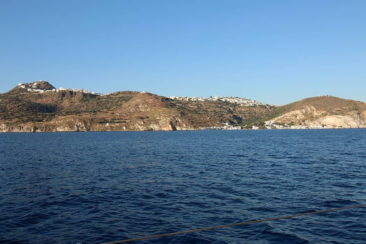
The ridge of Tripiti Milos faces the entrance of the great gulf on the northern edge. The village sits high on the slope, and the shore settlement of Klima lies directly beneath it, at the mouth of the bay. The distance to Adamantas, the main port, is five kilometres to the north-west. Plaka, the island capital, stands close by, higher on the same group of hills. From the ridge, the bay, the harbour and the open sea lie in one view.
The name of Tripiti Milos comes from the volcanic rock under the houses. The stone is full of holes, made by erosion and human work, and the village takes its name from that hollow ground. Local people once used the caves as storerooms and stables, and in ancient times as family burial chambers. The settlement joined the municipality of Milos in 1835, took the rank of a traditional settlement in 1978 and became the seat of its own community in 1912.
Restored windmills stand on the ridge and count among the sights of Tripiti Milos. They were once used to grind grain, and today they serve as lodgings. The height of the village gives a wide view over the bay, the port of Adamantas and the sea beyond. The settlement had 766 residents in 2021, and the houses gather on the slope in a tight pattern that follows the hill. The village keeps the character of a hill settlement above the water.
- Height: Tripiti Milos stands at 150 metres above the sea.
- Coast: The village looks over the entrance of the bay of Milos.
- Windmills: Restored mills on the ridge once ground grain for the village.
- Rock: Soft volcanic stone, full of holes, gave the village its name.
- Status: The settlement has held the rank of traditional settlement since 1978.
The ridge gives Tripiti Milos two things at once: a high, open view of the water and a short walk down to the shore. The village grew on ground that people had already hollowed out for storage and burial, and the old town below it left walls, a theatre and graves behind. The windmills on the skyline recall the farming past of the hill villages, when grain came up from the fields and left again as flour.
What lies below Tripiti Milos on the slope?
Below Tripiti Milos the ground falls to the sea in a slope that carries the remains of the ancient city of Melos: the catacombs, a theatre of Roman date and the field where the Venus de Milo was found, with the shore settlement of Klima at the bottom.
The catacombs lie beside the village, in the soft volcanic rock that gave Tripiti Milos its name. They form an underground Christian cemetery, the largest of its kind on the island, and their use runs from the middle of the first century to the seventh century AD. Three halls and their corridors run about 200 metres in all, with width from one to five metres and height from 1.6 to 2.5 metres. The catacombs of Milos keep carved tombs, painted arches and fragments of inscriptions.
The ancient theatre stands above the shore, on the slope between Tripiti Milos and the water. It was first taken for a Roman building of the first century AD, and it was located in 1735. The older Hellenistic part of the structure, from the third century BC, has since been found. The foundations of the stage, the orchestra and seven rows of marble seats survive, and those seats hold about 700 spectators. The site lies south of the plateau of the ancient market place.
A field near the village holds the find spot of the Venus de Milo, the marble statue of the Hellenistic years that came to light on the island in 1820. A farmer turned it up by chance, not knowing its worth, and the French service on the island learned of it and bought it. It travelled to France as a gift for King Louis XVIII, who gave it to the Louvre. Below the field, Klima keeps its boathouses at the water.
- Catacombs: The underground cemetery lies next to the village, in soft rock.
- Theatre: A Roman theatre stands on the slope above the shore.
- Find: The Venus de Milo came from a field near the village in 1820.
- Klima: The shore settlement below Tripiti Milos keeps painted boathouses.
- Walk: The sights below the village sit within a short downhill walk.
Everything below Tripiti Milos belongs to one small area, so the slope can be read on foot. The cemetery, the theatre and the field of the statue all sit on the ground of a single ancient city, and the shore below keeps its boats inside houses cut from the rock. The old town left walls, graves and works of art, and later builders took stone from it for churches and houses.
What is life like in Tripiti Milos today?
Everyday life in Tripiti Milos gathers around the church of Agios Nikolaos, built in 1888 in the centre of the village, the lanes that climb the hill, the light of the evening and the small places that serve food.
The church of Agios Nikolaos stands at the centre of Tripiti Milos and dates from 1888. It follows the plan of the church of the same saint on Syros, and it keeps a marble altar screen, an icon stand of the seventeenth century and icons of the Cretan school. The chapel of Panagia Faneromeni stands on the road toward the catacombs, with two arched tombs and traces of wall paintings inside. The parish of the village carries the dedication of the same saint.
The lanes of Tripiti Milos follow the slope, and the houses gather in a tight pattern on the hill. The settlement has held the rank of a traditional settlement since 1978, and its stone and its whitewash recall the island style. The parish of Tripiti carries the name of Agios Nikolaos, and the local calendar keeps its feast days. Plaka and Triovasalos lie in the same hill group and share one walking area with the villages of Milos above the port.
The evening brings the best hour to the ridge, because the village and the slope below it face the side of the water where the sun goes down. Tavernas and small eating places in the village and nearby serve simple local food in the open air, and the tables fill as the light goes. Walkers come up from the shore after a day at Klima, and the lanes stay busy until late in the warm months.
- Church: Agios Nikolaos stands in the centre, built in 1888.
- Lanes: Narrow ways climb the hill between the houses of the village.
- Evening: The village looks toward the water where the sun goes down.
- Tables: Small eating places in the village and nearby serve local dishes.
- Parish: The parish of Tripiti Milos carries the name of Agios Nikolaos.
A day in Tripiti Milos works on two levels. The village offers the church, the lanes and the windmills, and the slope below offers the catacombs, the theatre and the shore. The two parts sit close together, and the road between them runs downhill. Evenings return to the ridge, where the light on the water marks the end of the day and the tables of the village fill with people from the hill and from the coast.
What do visitors ask about Tripiti Milos?
Tripiti Milos holds a church, restored windmills and narrow lanes on a ridge above the bay, and beneath the village lie the catacombs, the ancient theatre, the find spot of the Venus de Milo and the shore settlement of Klima, all within a short walk of the lanes.
How high does Tripiti Milos sit above the sea?
The village stands at 150 metres above the water, on the northern coast of the island, at the sea entrance to the bay of Milos. The shore settlement of Klima lies below it, and the main port of Adamantas lies five kilometres to the north-west. Plaka, the capital, stands close by, higher on the same group of hills.
What is there to see below Tripiti Milos?
The slope below the village carries the catacombs, an underground Christian cemetery used from the middle of the first century to the seventh century AD, and a theatre of Roman date above the shore. A field nearby holds the find spot of the Venus de Milo, found in 1820. Klima, the shore settlement, keeps its boathouses at the water.
Which church stands in Tripiti Milos?
The church of Agios Nikolaos stands at the centre and dates from 1888. The wooden icon stand inside dates from the seventeenth century, and the icons belong to the Cretan school. On the road down to the catacombs stands the chapel of Panagia Faneromeni, with two arched tombs and traces of wall paintings inside it.
What happened to the windmills of Tripiti Milos?
Restored windmills stand on the ridge and belong to the sights of the village. They once ground grain, and today they serve as lodgings. The mills mark the farming past of the hill villages, when grain came up from the fields around the group of settlements. The settlement has held the rank of a traditional settlement since 1978.
Does Tripiti Milos keep old lanes and houses?
Lanes climb the slope between the houses, and the buildings stand in stone and whitewash in the island style. The village had 766 residents in 2021, and the community also takes in the shore settlement of Klima. Plaka, the capital, stands higher on the same group of hills, and a walking route links the two villages.
When does the light fall on Tripiti Milos?
The village and the slope below it face the water where the sun goes down, so the late hours bring the strongest light on the bay. The island has a Mediterranean climate, with mild, wet winters and warm, dry summers. The lanes and the tables of the village stay busy until late in the day during the warm season.