Route No. 1 covers a distance of 6.7 km and lasts about 3 hours. We start hiking from the caves of Papafragkas, and on our right we see the archaeological site of Filakopi, the oldest city of the Cycladic civilisation. Next we see Kapros beach, the village and the two Pachena beaches. On the way we also see the hexagonal volcanic formations, similar to those of Glaronisia. While hiking we pass the village and the beach of Agios Konstantinos, the beach of Alogomantra and Kofto, a tiny island separated from the land by a narrow strip of water. As we go on, for almost one kilometre we walk on white geological formations along the sea. Then we come to the village and the beach of Mitakas, where we have a short 5-minute break at the beach bar for a quick refreshment. Then we enter the wider Sarakiniko area, where there are many small beaches. Near the end of our journey we see the shipwreck of a merchant ship, and then we finish our hike at Sarakiniko beach. Along the route we make several breaks to take photos and rest, and at some point we also have a fifteen-minute break for lunch. Price: 25 euros
Milos is a volcanic island in the Aegean Sea and the south-western island of the Cyclades. The island has the shape of a horseshoe around a large gulf, and its north shore runs past coves, small beaches and pale rock. One long walk follows that shore. Readers who want wider Milos island information can begin on that page.
This page sets out a walk of the island, from the caves of Papafragas along the north coast to the white rock of Sarakiniko. It covers the distance, the start, the beaches and villages on the way, and the volcanic geology underfoot. The Papafragas hike Milos route holds all of it. A short list of questions about the same walk follows at the end.
What does the Papafragas hike Milos route cover from the caves to Sarakiniko?
The Papafragas hike Milos route follows the north coast for 6.7 kilometres, from the caves of Papafragas past Kapros, the two Pachena beaches, Agios Konstantinos, Alogomantra, Kofto and Mytakas, and ends at Sarakiniko beach, on the white north shore.
The Papafragas hike Milos route covers 6.7 kilometres of coast, and the sea stays on one side for the whole walk. The ground changes from one cove to the next, so rock shelves, sand and dirt roads take turns underfoot. The line of the coast holds the direction where a path fades, and the walker follows the shore rather than a marked line on the ground. Every bend opens a new view of water and pale rock.
The order of the places is fixed. The Papafragas hike Milos route leaves the caves of Papafragas, passes the ruins of Phylakopi on one side, and reaches Kapros and the two Pachena beaches, which face the Glaronisia islets. Agios Konstantinos comes next, then Alogomantra and the islet of Kofto. The village and beach of Mytakas follow, and then the wider Sarakiniko area opens with its group of small beaches, the wreck of a merchant ship and the white shore where the route ends.
The north coast of Milos is a line of pale volcanic rock above deep blue water. The rock above the shore is a stack of layers, and sandstone with pumice breccia forms part of it. The Papafragas hike Milos route keeps to that ground. Sand appears in short strips between the rock shelves, each strip inside its own small bay. The white rock around Sarakiniko carries no green at all, and the shore there looks bare and bright in the middle of the day.
A visitor who walks the Papafragas hike Milos route stays on open ground for the whole way. A hat, water and steady shoes belong in the bag, because shade is thin and the white rock throws light back at the walker. Swims break the walk at Kapros, at Agios Konstantinos and in the small coves of the Sarakiniko area. The end of the route is easy to reach by car and by bus from the main road.
- Distance: The Papafragas hike Milos route runs 6.7 kilometres along the north coast.
- Start: The walk begins at the three caves of Papafragas, beside the ruins of Phylakopi.
- Finish: The route ends at Sarakiniko beach, on the white rock of the north shore.
- Places: Kapros, Pachena, Agios Konstantinos, Alogomantra, Kofto and Mytakas stand on the way.
- Ground: Rock shelves, sand and dirt roads follow one after the other beside the sea.
The route gathers the north coast of Milos into one walk. It starts at a cave beach with a Bronze Age site beside it, follows the shore past a row of coves and small settlements, and finishes on the white rock of Sarakiniko. The distance is 6.7 kilometres, and the sea stays in view for the whole way. Walkers who want the wider picture of the island can turn to other routes for hiking in Milos.
Where does the Papafragas hike Milos route begin, at the caves and Phylakopi?
The Papafragas hike Milos route begins at the three caves of Papafragas, a small cove cut into pale rock, with the prehistoric settlement of Phylakopi standing beside the path and the ruins of the ancient city lying a short step from the water.
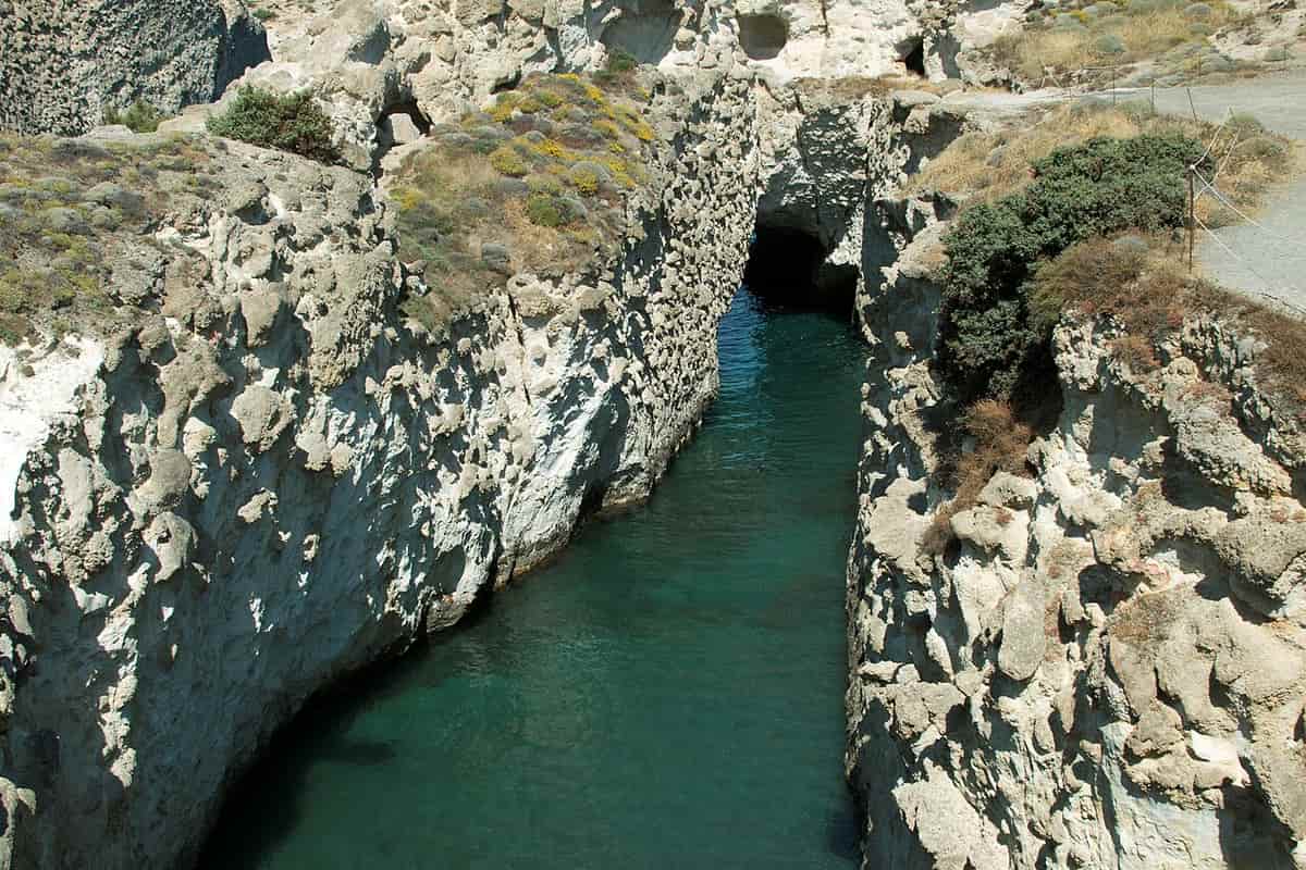
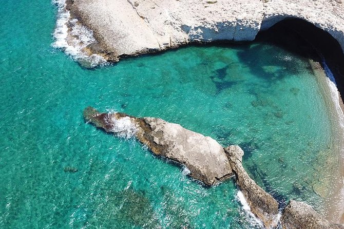
Three caves belong to Papafragas, and the beach sits at the bottom of a steep carving in the rock. One of the caves is a deep sea cave, and swimmers move through turquoise water between grey and white rocks that lead out to the open sea. The beach itself is small, closed in by bright rock walls, and the ground around it is pale stone. The Papafragas hike Milos route meets these caves at its first stop.
The Papafragas hike Milos route starts beside Phylakopi, and the site ranks among the leading settlements of Cycladic culture. Traces of habitation run from the Early Bronze Age, around 3000 BC, to the end of the Late Bronze Age, in 1100 BC, so remains of two millennia stand on the ground. Trade in obsidian made the town a commercial centre, and the ruins include a cyclopean wall, a sanctuary and a palace. The greater part of the city now lies below sea level.
The settlement held its ground through the whole Bronze Age. Minoan forms appear in the second phase of the settlement and Mycenaean influence follows in the third, when a megaron rose on the site with a main hall of about 8.6 by 6.2 metres and a central hearth. Excavation work began in 1896 and continued to 1899, and a later campaign revealed a sanctuary with figurines. The Lady of Phylakopi, a wheel-made figure of a goddess or priestess, came from the West Shrine.
A walker who starts the Papafragas hike Milos route meets two things at once, a cove below and a prehistoric town beside the path. The caves served as a base for pirates in Byzantine times, and the name of the place comes from the last Frank Pope, who kept his boat in the cove. The water in the small bay stays calm, and the view takes in the open sea. Photos come easily at this first stop.
- Caves: Three caves belong to Papafragas, and one of them is a deep sea cave.
- Descent: A steep carving in the rock leads down to the small beach below.
- Site: Phylakopi holds a cyclopean wall, a sanctuary and a palace.
- Phases: Minoan forms mark the second phase and Mycenaean ones the third.
- Finds: The Lady of Phylakopi came from the West Shrine on the site.
The start of the walk carries the weight of the island’s past. A cave beach opens below the path, and a Bronze Age settlement stands beside it, with a wall, a sanctuary and a palace inside its bounds. The sea has taken the greater part of the town, and the rest waits a short step from the water. From this point the route follows the coast to the next coves.
Which beaches and villages does the Papafragas hike Milos route pass?
The Papafragas hike Milos route passes Kapros, the two Pachena beaches, Agios Konstantinos, Alogomantra, the islet of Kofto and the village of Mytakas before the small beaches of the Sarakiniko area, where the walk ends beside the water.
The Papafragas hike Milos route reaches Kapros first, a small cove between white rocks with fine sand and blue water, and the main road to Pollonia runs in view of it. The village of Pollonia stands at the north-eastern end of Milos, at an elevation of 10 metres, and it forms the second port of the island. The two Pachena beaches come next, spacious and sandy, with tamarisk trees at the back, and they face the Glaronisia islets across the water.
Agios Konstantinos is a sandy beach in a small harbour closed in by rocks, with turquoise water and two small caves, and it takes its name from the church that stands there. The islet of Kofto follows, a tiny island cut off from the land by a narrow strip of water, and the Papafragas hike Milos route passes it on the way. Between these stops the coast opens and closes, and the ground keeps changing underfoot.
Alogomantra is a strip of sand closed in by high cliffs, and it stays out of sight from the road. The ground slopes down through rock to shallow green-blue water, and the shape of the bay gives the place its name. The village and beach of Mytakas come next, a sandy shore between narrow capes with houses of fishermen behind it and clear water in front. The Papafragas hike Milos route reaches Mytakas before the last stretch of the coast.
After Mytakas the wider Sarakiniko area opens, and a group of small beaches sits inside it. The Papafragas hike Milos route ends there. The sand at Sarakiniko itself forms a short strip, ten metres long, between white rock formations. A small natural harbour lies closed between the rocks, with a sandy floor and green-blue water, and the west side shows bare white rock in long shapes. The shore is not organised, and visitors reach it by car and by bus.
- Kapros: A small cove between white rocks, with fine sand and blue water.
- Pachena: Two spacious sandy beaches with tamarisk trees, facing the Glaronisia islets.
- Agios Konstantinos: A sandy beach in a rock harbour, with two small caves.
- Alogomantra: A strip of sand under high cliffs, out of sight from the road.
- Mytakas: A sandy shore between narrow capes, with houses of fishermen behind it.
The line of coves gives the walk its shape. Kapros and Pachena open the middle of the route, Agios Konstantinos and Kofto follow, and Alogomantra and Mytakas bring the walker to the Sarakiniko area. The Papafragas hike Milos route gathers them in one distance, and the sea stays close for the whole way. Walkers who want the other shores of the island can look at the beaches of Milos by area.
What geology lies under the Papafragas hike Milos route?
The Papafragas hike Milos route crosses a stack of volcanic layers, from hexagonal formations near the Glaronisia islets to the white Sarakiniko formation, and passes a wrecked merchant ship near the end, where the shore turns bright and bare.
North Milos is built of volcanic layers laid one above the other. The lowest and oldest is the Pachaina formation, at least 70 metres thick, and the Papafragas formation lies above it, growing thicker toward the east. The volcanic material of the two formations appears to have been laid down by wave action. Hexagonal formations stand near the start of the Papafragas hike Milos route, and they take after the columns of the Glaronisia islets.
About 1.85 million years ago, new volcanic material began to settle and formed the Sarakiniko formation. It is made of sandstone layers with pumice breccia and siltstones that hold fossils, and it reaches a thickness of about 50 metres. The formation started below the sea and rose by degrees to the surface, so the white rock of the shore was once under water. Waves still shape the greyish-white rock along this coast, and the Papafragas hike Milos route crosses it on foot.
Fossils in the rock of the north shore include bivalves, scaphopods, gastropods, brachiopods, echinoids and barnacles. Microfossils of diatoms date to between 1.95 and 1.73 million years ago, at the start of the Pleistocene, in ground that the Papafragas hike Milos route crosses today. Higher in the sequence, in the west, lies an andesite layer called Korakia, formed 1.8 million years ago, and sediments with material from phreatic eruptions of historical times sit at the top.
For nearly one kilometre the walk crosses white geological formations beside the sea. Waves driven by north winds have shaped the greyish-white volcanic rock, and erosion by wind and water gave the bone-white shore its long forms. Waves have also cut caves along the coast, and the shore takes its name from the pirates who sheltered in them. Ship bollards remain carved into the rock. Near the end of the walk the wreck of a merchant ship lies on the shore, and it appears when the waves pull back.
- Layers: The Papafragas hike Milos route crosses the Pachaina formation and the Papafragas formation.
- Age: The Sarakiniko formation began about 1.85 million years ago.
- Fossils: Bivalves, gastropods and barnacles count among the fossils in the rock.
- Columns: Hexagonal formations stand near the start, like the columns of the Glaronisia islets.
- Wreck: The wreck of a merchant ship lies near the end of the walk.
The geology gives the walk its two faces. The start runs over dark volcanic layers and hexagonal columns, and the end runs over white sandstone with pumice breccia, siltstone and fossils. The distance between them is 6.7 kilometres, and the Papafragas hike Milos route crosses ground that changes with every cove. A walker who reads the rock walks a short history of the island, from old flows to a shore that rose from the sea.

What do walkers ask about the Papafragas hike Milos route?
The Papafragas hike Milos route raises questions about distance, ground, water, the end of the walk and the white rock of the shore. The answers below follow the order of the route, from the caves of Papafragas to Sarakiniko beach.
How long is the Papafragas hike Milos route?
The Papafragas hike Milos route covers 6.7 kilometres along the north coast of Milos. The walk runs from the caves of Papafragas to the beach of Sarakiniko, and the sea stays beside the walker for the whole distance. The ground is level rock in places and dirt road in others, and the line of the coast keeps the direction clear.
Where does the Papafragas hike Milos route start?
The Papafragas hike Milos route starts at the caves of Papafragas, on the north coast. Three caves belong to the place, and one of them is a deep sea cave. The beach below is small, and a steep carving in the rock leads down to it. The prehistoric settlement of Phylakopi stands beside the path.
Where does the Papafragas hike Milos route end?
The Papafragas hike Milos route ends at the beach of Sarakiniko, on the white rock of the north shore. The sand there forms a short strip between white rock formations, and a small natural harbour lies closed between the rocks, with green-blue water. The shore is easy to reach by car and by bus.
Is the ground of the Papafragas hike Milos route rough?
The ground of the Papafragas hike Milos route changes from one cove to the next. Rock shelves, sand and dirt roads take turns underfoot, and the shore keeps a level line in long stretches. The walk stays close to the water, and the surface is bare rock for much of the distance. Shoes with a firm sole suit rough parts.
Can a visitor swim on the Papafragas hike Milos route?
Swimming is part of the Papafragas hike Milos route. Kapros, Agios Konstantinos and the small beaches of the Sarakiniko area all offer a dip, and the water stays clear in the coves. The deep sea cave at Papafragas holds turquoise water between grey and white rocks. At Sarakiniko a small natural harbour lies closed between the rocks.
How does a walker follow the Papafragas hike Milos route?
The Papafragas hike Milos route follows the coastline, and the sea marks the way. The walker keeps the water on one side and moves from cove to cove, so each named beach shows progress along the shore. Rock shelves and dirt roads carry the route between the stops, and the line of the shore brings the walker to Sarakiniko.
What belongs in a bag on the Papafragas hike Milos route?
Water comes first on the Papafragas hike Milos route, because the ground is open and shade is thin. A hat, sun cream and light clothing keep the sun off the skin. Shoes with a firm sole handle the rock shelves and the sand, and a camera suits the caves, the coves and the white rock at the end.