Route No. 3 (Paliochori – Firlingos) covers a distance of 6.6 km and lasts about 3-3.5 hours.
Price: 35 euros. Transport, equipment, food and safety are included.
The south-east coast of Milos holds a paddling line that starts on a beach of coloured pebbles and ends below a quiet cove. The pages of this Milos travel site follow that shore in detail. The kayak Paleochori route is one of them, and it keeps to the water from the first stroke to the last.
The island is volcanic, and its southern shore shows that clearly. Rock in red, yellow and white stands above the water, and the ground keeps a warmth that comes from deep below. A paddler meets that coast from the sea, at eye level with the stone, the caves and the open horizon. This page follows one line of that shore.
What is the kayak Paleochori route at a glance?
The kayak Paleochori route runs 6.6 km from the main beach of Paleochori to Firlingos, on the south-east coast of Milos. Transport, equipment, food and safety come with the trip, which follows the shore eastward and turns back to a cave of warm water.
The route opens at the central beach of Paleochori. A paddler turns left along the sand and reaches the next cove of the same village, a strip marked as a nudist beach, before Cape Spathi. From there the line of travel bends toward the east side of Milos. The two distant islands of Polyaigos and Folegandros stand in the haze ahead, and the open sea lies below them. A kayak Paleochori paddle keeps to this line.
Milos sits at the south-western end of the Cyclades, just north of the Cretan sea. It measures about 23 km from east to west and 13 km from north to south, and its area is estimated at 151 square kilometres. Paleochori lies on the southern coast, far from the harbour and the great gulf. The kayak routes of Milos therefore start on a shore that faces open water rather than a sheltered bay. That position shapes the day.
A list of 90 beaches places 21 of them on the southern side of the island. Read from east to west, that group opens with Psarovolada and Agia Kyriaki, then runs through Firlingos, Spathi and Tourkaki before reaching Paleochori. The kayak Paleochori route travels the same stretch in the opposite direction. West of the starting beach come Tourlos, Gerakas and, further away, Firiplaka. Part of the island shore can be reached only from the sea.
Milos is a stratovolcano that has not erupted in historical times. Volcanic activity began 2 to 3 million years ago and stopped 90,000 years ago. Two extinct volcanoes stand on the island, and Firiplaka, in the south-east, is the nearer of them to this coast. Rock in white, red, yellow and black appears along the shore, and the kayak Paleochori line passes beneath cliffs that owe those colours to that past. The heat below is another matter.
- Distance: The line covers 6.6 km between Paleochori and Firlingos.
- Start: The paddle begins at the central beach of Paleochori.
- Finish: The route ends at Firlingos, on the south-east coast.
- Included: Transport, equipment, food and safety come with the trip.
- Return: The way back stops at a cave of warm water at the edge of Paleochori.
The kayak Paleochori route holds one clean line of coast. It opens on a long beach of coloured pebbles, passes a cape and three small shores, and finishes below Firlingos. The return leg adds a cave where the sea itself is warm. Distances, rock and water carry the story from the first stroke to the last, and the island of Milos keeps its own pace behind the paddle.

What is the beach of Paleochori like on the kayak Paleochori route?
The kayak Paleochori route leaves from a beach almost 2 km long on the south coast. The shore brings together colourful pebbles, coarse sand, cool water and great depth. Around it stand rocks in red, pink, yellow and white-grey, and warm water springs from the ground.
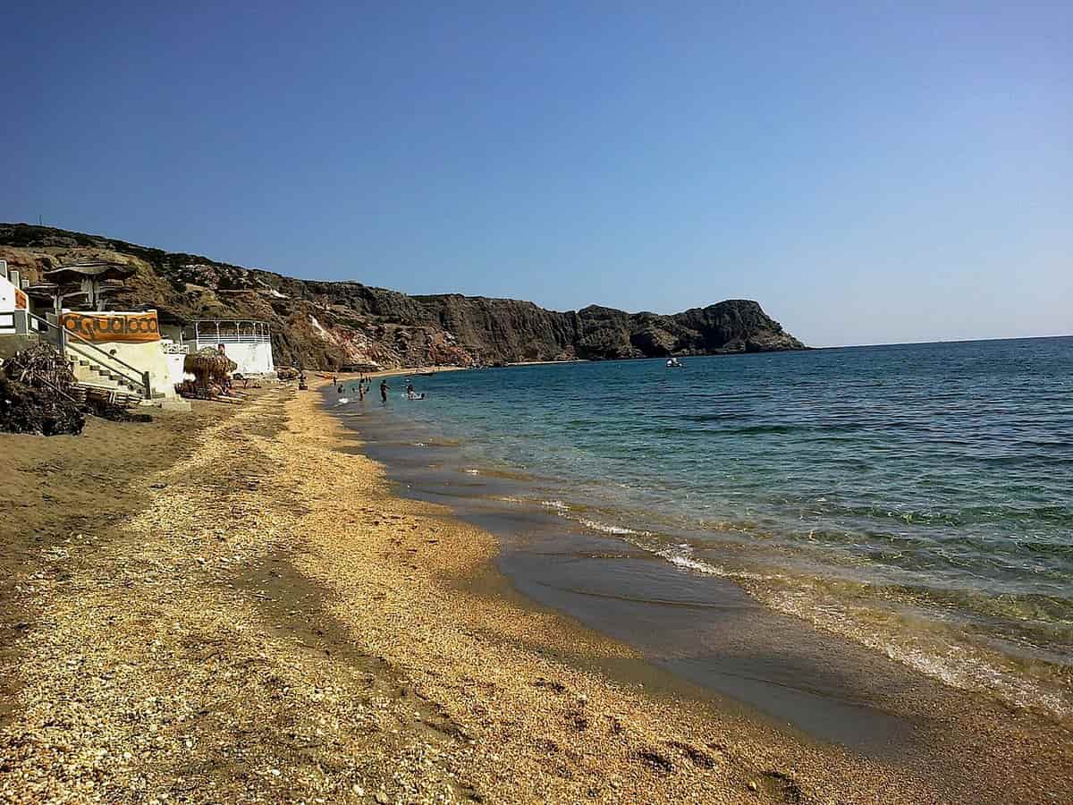
The starting beach belongs to a small settlement and a shore of the same name in the municipality of Milos. In the census of 2021 the settlement held 17 residents, against 25 in 2011. Rooms for rent and places to eat stand near the sand. The beach is almost 2 km long, made of colourful pebbles and coarse sand, with cool, clear and deep water in front of it. The kayak Paleochori paddle begins on this surface.
The rocks around the bay carry strong colour. Red, pink, yellow and white-grey faces rise from the water, and the mixture of natural materials changes from one stretch of shore to the next. The shade comes from the energy of the volcano and from the geological life of the place. Above the sand the cliffs stand close to the kayak Paleochori line, so the colour is the first thing a paddler meets. That wall of stone frames the beach.
Warm water rises at Paleochori. The spot is one of the places on Milos with active fumaroles and solfataras, where the ground releases gas from inside the earth. Temperatures there reach 100 degrees Celsius. The same kind of ground appears at Agia Kyriaki, at Pyromenes and near the harbour. Sulphur is strong in the air at all of them. For the kayak Paleochori trip the heat shows itself before the first paddle stroke. It is part of the place.
Paleochori also holds traces of older work. The coastal sites of Milos from Roman times include this shore, together with Agia Kyriaki. Installations for the working of mineral earths stood there, with spaces for enrichment, stores, living quarters and pottery workshops. The mineral earths included Melian earth, alum, pumice and sulphur. The kayak Paleochori route therefore passes a shore where workshops once ran, and the sand still hides their remains. Melian earth was a white pigment for ancient artists.
- Length: The beach runs almost 2 km along the south coast.
- Surface: Colourful pebbles and coarse sand cover the shore.
- Water: The sea in front of the beach is cool, clear and deep.
- Colour: Red, pink, yellow and white-grey rock surrounds the bay.
- Heat: Warm water springs from the ground at Paleochori.
Paleochori gives the kayak Paleochori route its starting point. The sand is coarse, the pebbles are bright, and the water stays cool and deep close to shore. The cliffs above carry red, pink, yellow and white-grey faces, and warm water rises through the ground behind them. Old workshops left their marks on the same coast. The paddle begins, in short, on a beach that already contains the whole story of the southern shore.
What does the kayak Paleochori coast look like between the two ends?
The kayak Paleochori coast runs east from the starting beach past Cape Spathi to Firlingos. Three small beaches of Spathi stand along that stretch, and the water below them shows clear colour. The horizon ahead holds the islands of Polyaigos and Folegandros.
From the water the first landmark is Cape Spathi, a headland that closes the bay of Paleochori on its eastern side. In front of the cape sits the second cove of the village, a strip of shore that carries a nudist marking. The paddle then turns the corner into the eastern waters of Milos. Wind and swell meet a paddler differently there, and the kayak Paleochori line opens onto a longer, straighter coast. Shelter for landing is scarce here.
Three beaches of Spathi occupy the middle of the crossing. They lie one after another below low rock, and the water changes tone at each of them. Pebbles of pale and dark colour line the shore, and shallow shelves of stone run out under the surface. No road reaches this part of the coast of Milos, so the sand stays empty. The kayak Paleochori crossing is the simplest way to see all three in one line.
The open water lies to the south, and the horizon carries two islands to the east. Polyaigos, the largest uninhabited island of the Aegean, sits to the east of Milos, and Folegandros stands further away in the same direction. Between the kayak and that line of land there is nothing but sea. Nearer in, the coast shows sea caves and tunnels cut into the volcanic rock, and the beach of Firiplaka lies further west along the same coast.
From a kayak the scale of the shore reads differently than from a road. Cliffs that look low from land rise well above head height, and the colour of the rock shows in bands rather than patches. The three beaches of Spathi pass one by one, and Cape Spathi drops behind. Ahead the shape of Firlingos appears as a pale line under dark rock. The kayak Paleochori route stands at its widest along this stretch.
- Cape Spathi: The headland closes the bay on the eastern side.
- Spathi beaches: Three small shores lie between the cape and Firlingos.
- Landing: No road reaches this stretch, so the sand stays empty.
- Horizon: Polyaigos and Folegandros stand to the east.
- Rock: Sea caves and tunnels cut into the volcanic coast.
The coast between the two ends belongs to the kayak Paleochori route alone. A headland, three small beaches and a long wall of coloured rock make up the crossing. Land access is absent, and the water carries the only easy road. The islands on the horizon hold the paddler’s eye while the shore slides past. This stretch is the heart of the paddle, and it gives the southern coast of Milos its shape.
What waits at Firlingos on the kayak Paleochori route?
The kayak Paleochori route ends at Firlingos, the last named beach before Agia Kyriaki on the southern list. The paddle stops there for a swim and a meal on the sand. East of it begins a large organised beach with sunbeds, umbrellas and beach bars.
On the southern list Firlingos comes straight after Agia Kyriaki, reading from east to west. Immediately west of it lies Spathi, with Tourkaki next and Paleochori after that. For the kayak Paleochori trip, Firlingos is the third named beach beyond the start. The tourism pages of the municipality give it no page of its own, so the clearest picture of the surrounding coast comes from the neighbouring beach to the east. That neighbour sets the tone of the area.
Agia Kyriaki is both a settlement and a beach on the southern coast of Milos. It lies about 13 km south-east of Plaka, the seat of the municipality, and 10 km from the harbour. Its name comes from the small church that stands by the shore. Coarse sand and white pebbles cover the beach, the water is cool, and the shore widens into a long spread of sand. The kayak Paleochori route stops short of that busier shore.
The beach to the east is large and organised. Sunbeds, umbrellas, beach bars and a beach volleyball court stand along the sand, and rooms for rent and a restaurant lie within walking distance of the water. A land archaeological site with the ancient harbour stands in the same area, where storerooms are still visible. Those traces lie east of the end of the kayak Paleochori route. The settlement had 12 residents in 2021, against 31 in 2011.
The route ends at Firlingos for a simple reason. East of it the coast changes character into a busy, serviced shore, while west of it the beaches stay quiet and hard to reach by land. A stop at Firlingos gives a swim, a meal and a rest before the return leg. The nature of the kayak Paleochori trip keeps it on the lonelier side of that line, and the paddle turns back west along the same cliffs.
- Position: Firlingos comes straight after Agia Kyriaki on the southern list.
- Stop: The paddle breaks there for a swim and a meal.
- Neighbour: The next beach east is large, organised and busy.
- Church: Agia Kyriaki takes its name from a small church by the shore.
- Ruins: An ancient harbour with storerooms stands east of the route.
Firlingos is the far end of the kayak Paleochori route and its turning point. The beach lies one place short of the busy shore to the east, on a coast that keeps its quiet character. A break for swimming and eating comes before the return. Beyond the route the land holds an ancient harbour and its storerooms, a small church and a wide beach. The paddle then retraces the cliffs toward Paleochori.
How does volcanic heat show itself on the kayak Paleochori coast?
The kayak Paleochori coast shows volcanic heat in warm water, steam and coloured stone. Fumaroles and solfataras with temperatures up to 100 degrees Celsius open at Paleochori, Agia Kyriaki, Pyromenes and near the harbour. Hot springs on the island reach 55 degrees.
A fumarole is an opening in the ground that releases steam and volcanic gas without liquid or solid material. The steam forms when underground water is superheated by hot rock, and fumaroles appear in the last stages of volcanic action. A fumarole that releases sulphur compounds is called a solfatara. On Milos the active solfataras and fumaroles reach up to 100 degrees Celsius, and the sulphur is strong at each of them. The kayak Paleochori line runs through that zone.
Below the surface the same heat continues. Submarine vents release gas that rises to the surface as bubbles, so a paddler can pass through water that warms without warning. Hot springs on the island reach 55 degrees Celsius. At Kanava hot water full of salts leaves the sand and runs into the sea, and vents from the same source warm the salt water a short way offshore. Baths at Provatas and Alyki belong to the same list.
Milos is a stratovolcano without eruptions in historical times, and volcanic rock covers the greater part of the island. The extinct volcano of Firiplaka lies in the south-east, and its crater measures 1,700 metres across and about 220 metres high. Layers of ash, sand and fragments of perlite alternate inside it. Hot steam carrying hydrogen sulphide altered the rock at the edges of the cone and produced kaolin, while yellow sulphur crystals settle where the steam escapes.
The heat below has been measured before. Steam was found at a depth of 1,100 metres under Milos, and a pilot unit of 2 MW ran on the island and covered its electricity use for two years. A geothermal field was identified in the group of Milos, Kimolos and Polyaigos, the first of high temperature in the country. The same heat warms the water in the cave at the end of the kayak Paleochori route.
- Fumaroles: Steam and gas leave the ground without liquid or solid material.
- Solfataras: A fumarole rich in sulphur compounds takes that name.
- Temperature: Active solfataras and fumaroles reach 100 degrees Celsius.
- Hot springs: Springs on the island reach 55 degrees Celsius.
- Cave: The return leg stops at a cave of warm water on the beach edge.
The volcanic heat of the south-east coast is not a single spot. It shows in fumaroles and solfataras, in hot springs and in the coloured rock itself. Steam has been found far below the island, and the crater of Firiplaka stands close to the line of travel. A kayak Paleochori paddle crosses that zone at the level of the water, where the warmth arrives as a change in the sea rather than a plume of steam.

When does the kayak Paleochori paddle suit the south coast wind?
The kayak Paleochori paddle suits days with a north wind and a mild sea, because the south coast of Milos lies on the sheltered side of the island. A southerly wind strikes that shore directly. Early hours and the months around high summer give the calmest water.
The meltemi is the summer wind of the Aegean, and in the southern Aegean it blows mainly from the north-west. Its exact direction shifts with the relief of each place. Milos is the south-western island of the Cyclades, a little north of the Cretan sea, and the greater part of it is rugged and hilly. The kayak Paleochori line stays on the southern coast, on the side that faces away from that wind. The air arrives only after crossing the island.
The picture turns around when the wind blows from the south. Those winds come from the south and can reach high speeds, and over the sea they lift a heavy swell. The mild southern wind of the region is warm and damp and brings rain with it. In that weather the shore of Paleochori takes the waves head on, because the coast looks south. On such days the sheltered beaches of the bay or the north side of the island are the better choice.
The meltemi blows through the warm half of the year and is strongest in July and August. In late spring lighter north winds come first and hold for two to three weeks. The wind grows through the afternoon with the heat of the day and drops again at night, and it can rise without warning under a clear sky. Day trips by canoe-kayak run from April to October. For the kayak Paleochori line a morning start catches the quieter hours.
The sea warms in summer to between 19 and 24 degrees Celsius at the surface. The air over Milos reaches a mean daily maximum of 28.1 degrees Celsius in July and 25.2 degrees in September. Water and sand reflect the sun and raise the risk of burning, and a wet cloth loses up to half of its protection. Heat with steady paddling can push the body above 40 degrees. The kayak Paleochori trip is better started early, with water carried in the boat.
- Wind: The summer meltemi blows mainly from the north-west.
- Shelter: The south coast faces away from that wind.
- Season: Canoe-kayak day trips run from April to October.
- Timing: The wind grows in the afternoon and drops at night.
- Water: Water carried in the boat guards against heat and thirst.
For the kayak Paleochori route the wind decides the day. A north wind leaves the southern shore calm, while a southerly wind puts the coast straight into the swell. The meltemi season runs from April to October and peaks in high summer, and the hours before noon stay gentler than the afternoon. Water, cover and an early start are the simple defences. The paddle then follows the sheltered side of Milos.

What else do paddlers ask about the kayak Paleochori route?
Paddlers ask how far the kayak Paleochori start lies from the harbour and the island capital, what comes with the trip, and how to reach the beach without a car. Other questions cover the colours of the rock and the coast beyond the route.
How far is the kayak Paleochori start from the harbour and the capital?
Paleochori is both a settlement and a beach in the municipality of Milos. It lies about 14 km south-east of Adamantas, the harbour, and about 13 km south-east of Plaka, the capital. The settlement held 17 residents in the census of 2021. It belongs to the community of Trypiti, with Zefyria, Kanava, Klima and Schinopi.
How does a paddler reach the kayak Paleochori start without a car?
Buses cover parts of Milos, and the summer timetable is denser than in the rest of the year. Tickets are bought on board. Taxis on the island serve the harbour and the airport, about 4 km from Adamantas. No bus line reaches the airport. A transfer comes with the trip.
Which colours does the kayak Paleochori paddler see in the rock?
Rocks at Paleochori carry red, pink, yellow and white-grey faces, a result of the volcanic energy and the geological life of the place. Red and yellow stand out along the starting beach, and the same coast turns pink and white-grey further on. At Provatas, west of the route, golden-red sand takes its colour from iron oxides.
What does the kayak Paleochori paddler see on the horizon east?
Polyaigos and Folegandros fill the eastern horizon. Polyaigos is the largest uninhabited island of the Aegean, and its hills rise between 320 and 350 metres. It belongs to the Natura 2000 network, is a special protection zone for a rare migratory falcon, and its sea caves shelter the Mediterranean seal.
Why does the kayak Paleochori route turn back to a warm cave?
The return leg stops at a cave of warm water at the edge of Paleochori. The water is heated by the post-volcanic hydrothermal action in the ground of Milos. Hot springs and vents are recorded at Paleochori and at Agia Kyriaki. The cave closes the paddle on the beach where it began.
What is included on the kayak Paleochori trip?
Transport, equipment, food and safety come with the route. The paddle starts from the central beach of Paleochori, follows the coast east past Cape Spathi, and reaches Firlingos, where a break allows a swim and a meal. The way back stops at the cave of warm water. The trip covers 6.6 km in total.