
A Milos itinerary brings together the large bay, hill villages, and stretches of volcanic coast. Exploring Milos starts with these places, rather than a crowded list of stops to complete. Days centred on places leave room for the island’s past, its rocks, and time beside the water.
This Milos itinerary separates arrival places from days among villages, ancient sites, and beaches beside the sea. The north coast, a day afloat, and southern shores each receive their own place in the plan. The aim is a clear island outline, without turning each day into a race.
How does a Milos itinerary fit the island’s bay and villages?
A Milos itinerary starts with the large bay inside the island’s horseshoe shape. Adamas marks the main port on the bay’s north-east shore. Plaka and Trypiti stand on higher ground, while Pollonia adds another port to the picture.
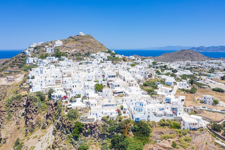
The horseshoe shape gives a Milos itinerary a clear point of reference. The bay reaches inland from the north-west, dividing the island into parts. A narrow strip of land keeps those nearly equal parts joined together.
Milos is a volcanic island, formed through volcanic activity in the Aegean. The large bay fills the island’s main crater, the opening left by volcanic activity. That hollow links the shape of today’s harbour with the island’s volcanic past.
Adamas gives this Milos itinerary a clear link between harbour and hills. A road rises from the port towards the high ground above it. Plaka, the island’s chief town, stands there beneath the castle hill nearby.
Trypiti shares the high ground above Adamas with Plaka and nearby Triovasalos. These places belong together in the opening picture of the island’s villages. Their position above the harbour distinguishes them from the port beside water.
Pollonia adds a different harbour setting to the outline of a Milos itinerary. It is the smaller port, used mainly for the link with Kimolos. Zefyria adds another village name, with its role as the former capital.
The western half has no villages, but tiny settlements and old mines. Its wilder character gives the island’s outline a contrast with the harbour. That difference matters when the plan moves from village days towards water.
- Bay: The large inlet gives the island its horseshoe shape and central point of reference.
- Adamas: The main port sits on the north-east shore of the island’s large bay.
- Plaka: The chief town stands on high ground beneath the castle on the hill.
- Trypiti: This village shares the raised ground above Adamas with Plaka and Triovasalos.
- Pollonia: The smaller port serves mainly as the link between Milos and Kimolos.
This Milos itinerary begins with the shape of the land rather than a fixed daily order. The bay, harbour, and hill villages provide the main points of reference. Later days bring the north coast, sea caves, and southern beaches into that same picture.

Where does a Milos itinerary begin on arrival?
A Milos itinerary starts at Adamas for sea arrivals, or at the airport for air arrivals. Adamas is the island’s main harbour on the bay. The airport lies south-east of that harbour, placing air arrivals elsewhere on the island.
Arrival places give a Milos itinerary its starting point, not its whole shape. Adamas provides the main port setting beside the island’s large natural bay. The hill villages and coastal places remain separate parts of the wider plan.
The airport’s position is best understood in relation to the harbour at Adamas. It stands to the south-east, rather than within the harbour town itself. This distinction keeps the arrival plan clear before village and beach days begin.
A Milos itinerary can mark Adamas and Pollonia as ports with different roles. Adamas is the main port, while Pollonia is the island’s smaller harbour. Pollonia mainly serves the link with Kimolos, rather than replacing Adamas in this outline.
The airport connects with the rest of Milos by car, taxi, and bus. These links belong to the arrival picture without setting a fixed daily route. The main distinction here remains the airport’s position away from the harbour itself.
Adamas also anchors a Milos itinerary through its place below the hill villages. The road from the harbour climbs towards Plaka on the ground above. Trypiti and Triovasalos share that raised setting, rather than the harbour’s shoreline position.
A plan centred on arrival places keeps the main harbour and airport distinct. It also separates both from Pollonia, the smaller port elsewhere on the island. That outline leaves the choice of village and beach days open after arrival.
- Harbour: Adamas is the main port and the starting point for the harbour picture.
- Position: The harbour town lies on the north-east side of the large bay.
- Airport: The island’s airport stands south-east of the harbour, away from the port itself.
- Links: From the airport, cars, taxis and buses reach every part of Milos.
- Hills: The road from Adamas rises towards the higher ground where Plaka stands.
The arrival part of a Milos itinerary needs clear places rather than a packed list of activities. Adamas, the airport, and Pollonia each have a distinct place in that outline. The days that follow can then focus on villages, ancient sites, and coast.
How does a Milos itinerary connect Plaka, Trypiti, and ancient sites?
A Milos itinerary can group Plaka, its castle hill, and Trypiti into a day on higher ground. From Trypiti, a short walk leads to the catacombs and the ancient theatre. These places connect village life with the island’s past above the bay.
Plaka gives a Milos itinerary a hilltop setting above the island’s gulf. The chief town stands on a large rock, with the castle higher still. Cars cannot enter its narrow alleys because buildings leave too little space.
The castle crowns a hill formed by the island’s earlier volcanic activity. Its high position let its builders control ship movement within the bay. The view links the castle’s role with the water spread out below.
Trypiti brings the Milos itinerary towards caves, old windmills, and the ancient town. The village stands in tiers and is almost joined to nearby Plaka. Its old windmills once ground grain, adding another layer to village history.
The catacombs of Milos are an ancient Christian cemetery built below the ground. They were cut into soft volcanic rock on the ancient city’s hillside. Their position near Trypiti places them beside the village part of the day.
The ancient theatre adds another historic stop to this part of a Milos itinerary. Built during the Roman period, it stands above the seaside settlement of Klima. Its seating follows the natural slope of volcanic rock.
The ancient town once covered the hillside from Trypiti down to Klima. The theatre and cemetery belong within this wider setting above the sea. This places their remains within a landscape, not isolated stops.
- Plaka: The chief town sits on a large rock overlooking the gulf of Milos.
- Castle: The hilltop position once helped its builders control ships moving through the bay.
- Trypiti: Old windmills remain from the village’s past role in grinding grain.
- Catacombs: This underground Christian cemetery was cut into soft volcanic rock near Trypiti.
- Theatre: The Roman theatre stands above Klima, with seating shaped into the natural slope.
This Milos itinerary groups the hill villages with the ancient places below them without flattening their differences. Plaka centres on the chief town and castle, while Trypiti brings the cemetery and theatre closer. The shared hillside gives the day a clear thread across the landscape.
Which north coast places belong in a Milos itinerary?
A Milos itinerary on the north coast links Sarakiniko, Papafragas, Phylakopi, and Pollonia. The focus changes from pale volcanic rock to caves and an ancient settlement. Pollonia adds a harbour and sandy beach at the island’s north-east tip.
Sarakiniko gives a Milos itinerary a close look at rock shaped by wind and waves. Its grey-white volcanic surface lies along the island’s northern shore beside the sea. The pale landscape has drawn comparisons with the surface of the moon.
The sand at Sarakiniko beach fills just a small corner of the wider rocky setting. Fine white sand lies between the rocks, with trees giving patches of shade. The distinction between beach and rock matters when picturing this stop.
Papafragas adds caves to a Milos itinerary beside the ruins of nearby Phylakopi. Its deep sea cave opens towards the water beyond the grey-white rocks. The small beach has a steep approach cut into the surrounding pale rock.
Phylakopi brings the coast’s ancient settlement into focus beside the caves at Papafragas. A wall built with large volcanic blocks remains part of its physical setting. Over time, waves have carried off part of the settlement.
Pollonia gives this Milos itinerary a harbour stop at the island’s north-east tip. Local fishing boats bring in fish, octopus, and lobster to the village port. Its sandy main beach adds a different coastal setting from the pale rocks.
The north coast plan brings different kinds of place into the same day. Sarakiniko centres on rock, while Papafragas places caves beside the remains of Phylakopi. Pollonia changes the focus again, with its port and sand beside the village.
- Rock: Sarakiniko’s grey-white coast takes its shapes from the action of wind and waves.
- Sand: The beach at Sarakiniko fills only a small part of its wider rocky setting.
- Caves: Papafragas lies next to Phylakopi and has a steep approach to its small beach.
- Settlement: Phylakopi has a wall built from large blocks of volcanic rock.
- Harbour: Pollonia stands at the north-east tip and has a sandy main beach.
The northern part of a Milos itinerary works as a changing picture of rock, settlement, and harbour. Each place adds a different detail without needing the same kind of visit. The result is a coast day with room for landscape and the island’s past.
How can a Milos itinerary include a day at sea?
A Milos itinerary can include Kleftiko and coastal places reached from the sea. Boat outings reach beaches without land access and reveal caves along the island’s edge. Kleftiko brings grey-white rocks, while Sykia adds a cave open to sunlight.
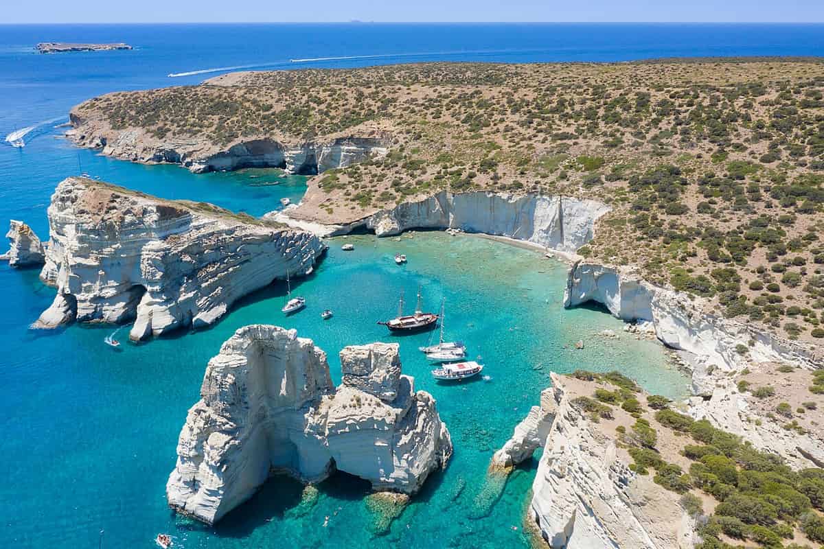
Kleftiko brings sea-shaped rock into the offshore part of a Milos itinerary. Air and water have shaped its grey-white formations over the passing centuries. Caves and hollows give these rocks a different outline from a sandy beach.
Pirates once hid at Kleftiko and used it as their base. That past is linked to the name still used for these rocks today. The place joins coastal shapes with a story of shelter at sea.
Sykia adds a different cave setting to the sea day in a Milos itinerary. Access comes only from the sea, setting it apart from land-based stops. Its roof has fallen in, letting sunlight fall on the green water.
Sea outings reach beaches that have no access from the island’s land. They also bring the island’s mineral wealth and hidden caves into view. These are reasons for a sea day rather than another village circuit.
Ports give the sea day in a Milos itinerary clear points of reference. Boats leave from Adamas and Pollonia for outings around the island’s coast. Kipos has a small port where boats set out towards Kleftiko’s rocks.
The western half of Milos has tiny settlements rather than village centres. This wilder setting contrasts with the harbour and the villages on higher ground. The sea day keeps its focus on coastal rocks, caves, and water.
- Rocks: Kleftiko has grey-white formations shaped by air and sea over the centuries.
- Past: Kleftiko’s name is linked to its former use as a shelter and base for pirates.
- Cave: Sykia is reached only from the sea and has no roof above its green water.
- Ports: Adamas and Pollonia are departure places for boat outings around the island.
- Kipos: The small port is another departure point for boats heading towards Kleftiko.
A sea day gives the Milos itinerary a view beyond the harbour and the village streets. The focus rests on caves, open water, and rocks shaped along the island’s edge. Kleftiko and Sykia remain distinct places within that wider view of the coast.
Which south coast beaches fit a Milos itinerary for the day?
A Milos itinerary can group Firiplaka, Tsigrado, Paleochori, and Agia Kyriaki around a southern beach day. Each place brings a different shoreline or approach. The plan keeps the beaches distinct rather than treating every stretch of coast as alike.
Firiplaka gives a Milos itinerary a beach beside a large rock in the water. A cave sits beneath that rock close to the shore, adding another coastal feature. Tsigrado lies east of Firiplaka, with Provatas to the west.
The road towards Firiplaka has a paved surface along its greater part. The final stretch changes to gravel before the approach reaches the beach. That surface change belongs in the beach plan alongside the rock near shore.
Tsigrado adds white sand and green water to the beach choices in a Milos itinerary. The beach lies among rocks beneath a steep path covered with sand. Its approach is part of the choice, not a detail apart.
Paleochori brings red, pink, yellow, and white-grey rock into the southern beach picture. Its shore has coloured pebbles and coarse sand beside deep, clear water. Warm water also rises here, adding another detail to this coast.
Agia Kyriaki gives a Milos itinerary a beach with sunbeds and umbrellas. A volleyball court adds another feature to this large stretch of shoreline. These details distinguish it from Tsigrado, where the beach has no organised facilities.
Beach choice depends on wind direction as well as the setting itself. During north winds, the southern side is a better choice for swimming. South winds instead favour beaches along the north side of the island.
- Firiplaka: Near the shore, a large rock rises from the water with a cave below.
- Tsigrado: White sand and green water lie below a steep approach covered with sand.
- Paleochori: Coloured pebbles and coarse sand meet deep, clear water beside rocks of different colours.
- Agia Kyriaki: This large beach has sunbeds, umbrellas, and a court for beach volleyball.
- Wind: The southern beaches are a better swimming choice when winds blow from the north.
The southern beach day completes this part of the Milos itinerary with contrasting shores and approaches. Firiplaka and Tsigrado bring nearby but different settings, while Paleochori adds coloured rock and warm water. Agia Kyriaki rounds out the beach choices with its larger setting.
How do fishing villages fit into a Milos itinerary?
A Milos itinerary links Klima with Mandrakia and Firopotamos through their seaside boat stores. These spaces, called syrmata, were cut into rock beside the sea. The visit centres on fishing life, painted doors, and the link between shelter and shore.
Klima stands below Trypiti, at the entrance to the island’s bay. That setting links a village visit with the higher ground above. A stop at Klima and its boat stores adds a clear theme to the day.
Syrmata are boat garages cut into volcanic rock beside the sea. Their name comes from fishermen dragging boats from their sheltered spaces. Winter weather explains the need for shelter, rather than decoration alone, along this working shore.
The doors and windows in Klima have strong painted colours. Boats stayed on the ground floor, while families lived above them. This layout brings home life and boat care together within the same small stretch of village.
Mandrakia also has boat stores beside its small village beach. Fine dark grey pebbles and tamarisk trees mark the shore there. A village stop can focus on these details without turning the visit into another beach day.
Firopotamos has a sandy beach beside a bay surrounded by boat stores. Tamarisk trees also form part of this small seaside setting. Its beach suits swimming and fishing, adding another possible focus to a village visit.
This part of a Milos itinerary works as a comparison between places. Each stop brings attention back to boats, shelter, and the sea. A slow walk along the water shows the boat garages up close.
- Klima: Painted doors mark boat stores.
- Mandrakia: Dark pebbles line the beach.
- Firopotamos: Sand borders the small bay.
- Syrmata: These spaces sheltered fishing boats.
- Focus: Village life connects the stops.
A village visit gives the Milos itinerary a clear link between buildings and daily work. The boat stores deserve attention beyond their painted doors and windows. A plan centred on these details leaves less pressure to add another distant stop.

How does the mining past enrich a Milos itinerary?
A Milos itinerary can pair the mining museum in Adamas with Thiorichia. The museum explains mining through work, materials, and the lives of miners. At Thiorichia, the remaining tools and buildings bring that subject into an outdoor setting beside the sea.
Thiorichia lies on the eastern side of Milos, beside the sea. Its setting is the small cove of Paliorema, with yellow pebbles. Clear water and old mine remains share the same stretch of this coastal landscape.
The old sulphur mines operated until 1956, and their ruins remain. Wagons still stand on rails, alongside rusty tools and unused parts. These objects make the visit about past work as well as the surrounding coastal scene.
The mining museum in Adamas gives this subject a broader setting. Its ground floor explores mining through people’s lives, money, and tools. That approach adds human concerns to a subject that otherwise begins with rocks and machinery.
The museum also shows minerals and their uses in everyday life. Films explain how these materials are taken out and then processed. Stories from older miners bring personal voices into the wider account of work on Milos.
A mining day can begin with questions rather than a long checklist. The museum gives attention to people, while Thiorichia presents visible remains. The activities in Milos plan can keep this theme separate from a swimming day.
- Museum: Adamas holds the mining displays.
- History: Thiorichia preserves old mine remains.
- Setting: Paliorema has yellow shore pebbles.
- Objects: Wagons remain on their rails.
- Voices: Former miners share their stories.
The mining theme gives a Milos itinerary space for learning as well as time outside. A museum visit and a coastal stop offer different ways into that subject. Neither needs extra beach stops merely to fill the day’s remaining space.
How can Kimolos and Polyaigos fit into a Milos itinerary?
A Milos itinerary can include Kimolos through the regular boat link from Pollonia. Polyaigos adds a separate island interest, with no human residents and sea caves. Any plan involving both islands needs clear travel arrangements rather than an assumed onward connection.
Pollonia is a fishing village at the northeastern tip of Milos. A small boat provides a regular link with neighbouring Kimolos. A Kimolos boat trip can therefore form the main focus of a day beyond the island.
Psathi is the harbour of Kimolos, with white houses and narrow lanes. Small boat houses also form part of the harbour setting. This gives the arrival a village focus before the plan turns towards another island stop.
Chorio is the main settlement of Kimolos, standing on a hill. Its position is in the southeastern part of the island. A plan centred on Psathi and Chorio leaves island life as the day’s main shared theme.
Polyaigos has no human residents, unlike the village settings on Kimolos. Its sea caves shelter monk seals whose numbers are falling. That fact gives a nature visit a different purpose from walking through a harbour or settlement.
The beaches of Polyaigos lie mainly on its southern side. Sea trips around Milos set out from Adamas and Pollonia. Polyaigos is uninhabited, so a day there is spent at sea and on its beaches.
- Departure: Pollonia links regularly with Kimolos.
- Harbour: Psathi has small boat houses.
- Settlement: Chorio stands on a hill.
- Polyaigos: No human residents live there.
- Wildlife: Sea caves shelter monk seals.
An island day gives the Milos itinerary a change of setting without needing a crowded route. Kimolos and Polyaigos offer different reasons for leaving the main island. Kimolos suits a village walk, while Polyaigos suits a day of swimming.
How can a Milos itinerary balance a 3-day and 5-day stay?
A Milos itinerary for a shorter stay can combine village visits with nearby themes. A longer stay can give mining and neighbouring islands separate space. Each plan keeps one area per day, so time on the road stays short.
A 3-day Milos itinerary can start with Plaka, Trypiti, and Klima. Klima lies below Trypiti, while Trypiti is almost joined to Plaka. This grouping keeps the opening day centred on settlements rather than mixing unrelated beach stops.
The next day can focus on the north coast and fishing villages. Mandrakia and Firopotamos belong to this northern group of beaches. A plan can choose village details or swimming as its main interest for that day.
The remaining day can centre on the south coast or a sea outing. Sea trips reach beaches that have no access from land. The choice depends on the planned experience rather than pressure to include every coastal area.
A 5-day plan can keep those themes while adding a mining day. The museum in Adamas and Thiorichia provide its linked interests. Kimolos can then take another day, with Polyaigos added by boat.
These plans leave the order open rather than fixing every beach first. Wind direction helps decide which coast suits a swimming visit. A north wind favours the bay or south, while a south wind favours northern beaches.
- Villages: Plaka, Trypiti, and Klima combine.
- North: Fishing villages share the focus.
- Coast: Beach or sea time follows.
- Mining: History gains a separate day.
- Islands: Kimolos adds another possible theme.
The shorter Milos itinerary selects themes, while the longer version separates them into less crowded days. Both plans still leave time each day for a swim or a rest. A clear daily focus leaves room for changed weather and personal interests.
Which transport choices support a flexible Milos itinerary around the island?
A Milos itinerary can use summer buses, cars, bikes, and boats for different needs. Buses serve parts of the island, while sea trips reach shores without land access. Route choice matters because dirt roads and village access bring limits to movement.
A bus based Milos itinerary needs stops matched to the available routes. Summer services run quite frequently, but coverage reaches only parts of Milos. The plan therefore starts with reachable places rather than a complete island checklist.
Car plans need a separate check for roads and village access. Cars cannot enter Plaka, where narrow spaces limit vehicle movement. A visit there needs an arrival plan that does not depend on driving through the village.
Bikes belong in route planning rather than being treated as universal transport. Longer marked routes can include travel by bike, car, or foot. The selected route needs to match the rider’s plans before other stops are added.
Dirt roads lead towards coastal places, chapels, and old mining sites. Parts of this road network are very difficult to travel. A route marked on a map therefore needs closer thought before becoming part of the day.
Boats add access that road travel alone does not provide here. Sea excursions leave from Adamas and Pollonia for beaches beyond land access. Their role is different from simply replacing a drive between the island’s village stops.
- Buses: Summer routes serve selected areas.
- Cars: Plaka does not allow entry.
- Bikes: Longer marked routes include cycling.
- Roads: Difficult dirt stretches need attention.
- Boats: Sea access opens other shores.
Transport works best within a Milos itinerary when each choice answers a clear travel need. A village visit, cycling route, and sea outing need different planning. Combining them starts with access rather than assuming every vehicle reaches every named place.

Which base fits a Milos itinerary centred on different daily interests?
A Milos itinerary can use Adamas, Plaka, or Pollonia as its main base. Adamas centres on the harbour, Plaka offers a hilltop setting, and Pollonia links with Kimolos. The choice can follow the planned days rather than a single ranking of places.
A Milos itinerary based in Adamas starts from the island’s harbour town. The mining museum gives the town a clear history interest. Sea excursions also leave from its port, adding another reason to consider this setting first.
Plaka stands on a large rock above the gulf of Milos. Its hilltop position gives this base a different setting from Adamas. Cars cannot enter the village, so transport plans need to account for that access limit.
Pollonia combines a fishing village setting with a regular Kimolos boat link. It also has a sandy beach in the village centre. A stay centred on these interests can keep the village itself within the daily plan.
Choosing a base begins with the places planned for repeated visits. Harbour days point towards Adamas, while Kimolos plans draw attention to Pollonia. A preference for Plaka’s hilltop setting gives another clear starting point for the decision.
The base does not need to become the subject of every day. Its role is to support the wider mix of planned interests. A base close to the planned days saves time on the road.
- Adamas: The harbour anchors the setting.
- Plaka: High ground overlooks the gulf.
- Pollonia: Kimolos has a regular link.
- Beach: Pollonia has a sandy centre.
- Choice: Planned interests shape the base.
The base gives a Milos itinerary its starting point, not a reason to repeat identical days. Adamas, Plaka, and Pollonia support different interests within the wider plan. The final choice can reflect the balance between harbour life, villages, and islands.
Which final choices help shape a balanced Milos itinerary?
A Milos itinerary also needs room for weather, family interests, walking, and onward travel. These choices help shape the days without adding a long list of stops. The questions below focus on practical decisions that sit outside the main daily themes.
Which month best suits a Milos itinerary with milder daytime heat?
September has lower average daytime highs than June, July, and August, making it an option for milder heat. Rainfall remains low across that period, though the north wind season continues into the middle of September. The best choice depends on the balance between warmth, wind, and the planned mix of outdoor activities.
What belongs in a Milos itinerary limited to a single day?
A single day Milos itinerary can centre on Adamas and the mining museum rather than distant coastal stops. That choice gives the visit a clear theme without making a complete island circuit its main purpose. A traveller focused on village settings can instead choose Plaka and leave other places for another stay.
How can a Milos itinerary work for travellers without a car?
Travellers without a car can build days around bus coverage instead of starting with a fixed island checklist. Summer buses serve parts of Milos quite frequently, while boats add access to beaches beyond road routes. A plan without a car keeps to places on the bus routes or on boat trips.
How can a Milos itinerary change during rainy or windy weather?
The mining museum in Adamas offers an indoor subject when a planned day outside loses its main appeal. Strong north winds can halt small boat routes, so an island crossing needs a separate weather check. Beach choice also follows wind direction, with bay and southern beaches favoured when the wind comes from north.
What deserves attention in a Milos itinerary planned around children?
A family plan can compare beach access and facilities before adding extra stops to an already full day. Tsigrado has a steep sandy approach, while Agia Kyriaki has sunbeds and umbrellas beside its beach area. These differences give adults concrete details to weigh rather than treating every beach as the same family outing.
How does hiking fit into a Milos itinerary focused on nature?
Marked routes explore the island’s rocks, nature, and history, giving walking days a theme beyond reaching a beach. Longer routes include options for cars, bikes, or walking, so the route choice comes before transport decisions. A hiking plan can focus on a selected route rather than adding a walk between unrelated sightseeing stops.
Which sunset spots belong in a Milos itinerary beyond beach visits?
Panagia Korfiatissa offers sea views and sunsets at the western end of Plaka, above steep rocks. Panagia Tourliani stands on the hill above Klima, where its courtyard also gives visitors a sunset setting. Either place can provide an evening focus without turning the end of the day into another crowded route.
How can a Milos itinerary connect with a wider island journey?
Summer sea links connect Milos with islands including Syros, Paros, Naxos, Tinos, Ios, Sikinos, Folegandros, and Santorini. These links give onward planning a broader range than the neighbouring island visit from Pollonia to Kimolos. These links make Milos an easy stop on a longer island trip in summer.