
Sarakiniko beach sits on the northern shore of Milos, an Aegean island born from volcanoes. The ground is a band of bare white rock, and wind and waves have cut and smoothed it. The Milos Advisor covers the island in plain English, with pages on its shores.
The sand at the site forms a short strip that sits between the white rocks. Deep blue water runs along the edge, and a small natural harbour opens in the stone. Visitors cross bare rock on foot, and good shade is hard to find in summer.
What is Sarakiniko beach like at a glance?
Sarakiniko beach is a band of pale volcanic stone along the northern shore of Milos. The sand forms a short strip of 10 metres. The rock sits about five kilometres from Plaka, the island capital, and it holds a small bay.
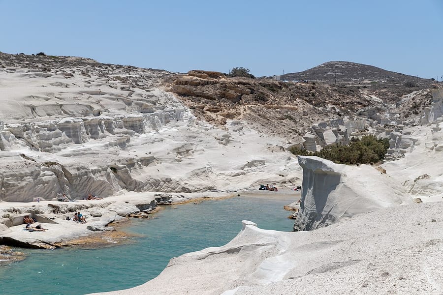
The white stone covers the whole ground here and gives the shore its pale colour. Very little grows on the ground there, so the bare rock carries the whole view. Water lies at the foot of the white stone, in deep blue and soft green-blue tones.
Visitors describe the setting at Sarakiniko beach as a moonscape, and local people call it Lunar. The comparison fits, because the stone is greyish-white and carries no trees at all. Wind from the north pushes waves against the shore and keeps cutting the soft rock.
The sand is thin and white, and it fills a small space between the rocks. A couple of trees stand at the back of the bay and give a little shade. The rest of the place is bare stone, open to the sky and to the full sun.
The two sides of the site look unlike each other, and the difference shows at once. The west side holds the bare rock shapes that draw visitors from across the island. The east side is a dry patch of low plants, stones and rough ground.
Fossils sit inside the layers of stone in the wider area around Sarakiniko beach. They include the shells of small sea creatures such as bivalves, gastropods and barnacles. Microfossils of diatoms, tiny sea plants with glass shells, date back to about two million years ago.
People treat Sarakiniko beach as a well-known sight among the beaches of Milos. The white stone and the deep blue water make the view stand out in photographs. The place sits close to the main road, and it draws crowds in the warm months.
- Setting: The site covers the north coast of the island, close to the main road.
- Sand: A short strip of white sand measures 10 metres in length.
- Water: Deep blue water meets the white rock along the whole shore.
- Rock: Bare stone holds the whole view, and little plant life grows there.
- Distance: The place lies about five kilometres from Plaka, the island capital.
Sarakiniko beach is a short stop on the north side of Milos, and the rock is the reason. The ground is easy to read: white stone, thin sand, deep water. Its shape, colour and open sky set it apart from the other shores of the island.

How did the white rock of Sarakiniko beach form?
Sarakiniko beach rests on layers of volcanic material that erupted long ago. Ash and pumice fell from the air, settled in layers and then hardened into rock. Wind and waves have since carved that soft rock into smooth and rounded shapes.
Rock made from settled volcanic ash has its own name, and that name is tuff. The ash binds into a solid mass and builds the shore at Sarakiniko beach. Pumice belongs to the same family of rocks, but it is lighter and full of small holes.
Milos is a volcanic island, and its volcanoes first woke 2 to 3 million years ago. About 90,000 years ago came its most recent eruption, and the volcano still counts as dormant. Soft tuff, grey trachyte and black obsidian rank among the usual rocks of the island.
The layers near Sarakiniko beach hold sandstone, pumice pieces and siltstone with fossils. About 1.85 million years ago, fresh volcanic material started to build a stack. The lowest and oldest layer of north Milos lies at the bottom, at least 70 metres thick.
Waves appear to have laid the material down, and the whole stack began under water. The ground rose by slow degrees until it reached the surface of the sea. Wind and sea then took over the slow work of cutting and smoothing the pale stone.
Waves driven by the north winds press hard against the soft white stone. They wear the surface down and open hollows along the whole line of coast. The sea keeps working on the rock at Sarakiniko beach, so its shape changes over time.
Milos holds other volcanic rocks as well, such as trachyte and glassy black obsidian. The white stone at Sarakiniko beach comes from material that is pale in tone. Pumice is light in colour when it forms, and the ash around it follows suit.
- Ash: Volcanic ash settles in layers and turns into solid rock called tuff.
- Pumice: This pale volcanic rock holds a great number of small holes.
- Layers: Sandstone, pumice pieces and siltstone sit together in a stack of layers.
- Water: Wave action helped to lay the whole stack of material down.
- Cutting: Wind and waves wear the soft stone into smooth and rounded shapes.
The rock of Sarakiniko beach is a record of eruptions, settling and slow wear. Ash and pumice built the layers first, and the sea added the final finish. The colour comes from the material itself, so the white stone stays pale through the seasons.
Where does the name of Sarakiniko beach come from?
Sarakiniko beach takes its name from pirates who used the bay as a shelter. The rocky coast offered hiding places and calm water for their ships. Caves along the shore served the same purpose in those past years.
Pirates needed safe anchorages that hid them from the view of passing ships. The bay at Sarakiniko beach closes between high rocks, which keeps the water calm. Sailors waited there for days and watched the busy sea lanes without being seen.
The name of the place is tied to those crews, and the link is very old. People link the name of the bay to pirates who once hid there. The story of the name belongs to the wider history of Milos.
Marks cut by people still survive on the white rock face at Sarakiniko beach. Stone bollards for mooring ships remain, carved into the rock. They mark the place where vessels tied up along the shore.
The name points to seafarers from the east who were known as Saracens. Those crews sailed the Aegean Sea and found refuge in the caves of the coast. The bay gave them shelter from wind and waves, and the name stuck to the place.
Local memory kept a short name for this rugged stretch of coast. Nothing in the landscape of Sarakiniko beach points to the pirate story on its own. The link lives in the name and in the marks cut into the stone.
The north coast of Milos faces the open Aegean Sea. Small coves along it gave boats a place to rest away from the main harbour. The bay at Sarakiniko beach belongs to that group of quiet coves.
- Origin: The name of the bay comes from pirates who sheltered there.
- Refuge: Caves along the coast gave the crews cover from the sea.
- Marks: Carved bollards for the mooring of ships survive on the rock.
- Crews: Saracen pirates used the quiet bays of the Aegean Sea.
- Survival: The story lives on in the name rather than in writing.
The pirate story gives Sarakiniko beach a human layer on top of the geology. A calm bay, good hiding places and cut bollards point to boats that waited there. The name keeps that past alive, even though the crews are long gone.
Is there a shipwreck near Sarakiniko beach?
Sarakiniko beach has a wrecked ship on its east side. The vessel ran aground there in 2003, and the sea has since broken it apart. Its metal remains appear when the sea draws back from the shore.
The east side of Sarakiniko beach looks dry, dusty and almost bare. Low plants and rough ground cover the whole surface of that side. A run of broken metal lies at the waterline, and it belongs to the old wreck.
Ships have long passed this coast on the way to the harbour of Milos. The shore is rocky, and the wind from the north can push a vessel onto it. A grounding leaves a hull open to the waves and to slow decay.
Waves cover the remains through the whole day in normal weather. When the water retreats, parts of the old iron hull become visible on the rocks. Visitors spot the wreck from the path above the shore, without going down.
The wreck has become part of the scene at Sarakiniko beach. Rust and iron slowly mix with the white stone, and the shape fades each season. The pieces near the waterline still tell of an accident that happened years ago.
The hull has stayed on this shore through winter after winter of wind and salt. Milos lies in the Aegean Sea, and boats pass this coast on the way to port. The old wreck is a mark of that passing traffic on the dry east side.
Safe viewing matters more than a close look at the broken metal. Loose iron and sharp edges sit near the water, and waves move over them. A look from the higher ground shows the whole wreck without any risk.
- Place: The wreck lies on the dry, empty east side of the site.
- Date: The ship ran aground on the shore in 2003.
- Visibility: The remains show when the sea draws back from the rock.
- Condition: Iron and rust have broken the old hull apart over time.
- Viewing: The path above the shore gives a clear and safe look.
The wreck adds a second story to Sarakiniko beach, next to the geology and the pirate name. It waits below the waterline and appears when the sea pulls back. A distant look from the white rock gives the safest view of the old hull.
What old openings in the rock can be seen at Sarakiniko beach?
Sarakiniko beach holds caves that waves have cut along the coast. The sea opened these hollows in the soft stone over a very long time. Pirates sheltered inside them, and boats tied up at the rock face nearby.
Caves line the shore at Sarakiniko beach, and they sit at water level. They began as small holes and grew as the sea kept working on the stone. The largest of them give shade and a good break from the wind.
Rock opened by the sea at Sarakiniko beach makes a natural shelter from wind and sun. Roofs of stone keep the sun off, and the walls block part of the wind. The floor stays wet, because waves run in and out of the open mouth.
People left their own marks on the soft rock as well as the sea. Bollards for the mooring of ships were cut into the stone. They sit near the water, where a boat pulled in and tied up.
The soft white stone takes a mark easily, and that leads to lasting damage. Visitors have carved their names into the white rock at Sarakiniko beach over the years. In 2015 the local authority brought in a fine for pollution of the area.
Small hollows and ledges appear along the whole line of the white cliff. Parts of them reach above the water, and other parts stay under it. Each one shows how long the sea has worked on this stretch of coast.
Shade inside one of these caves is welcome on a hot summer day. The floor is uneven and wet, and the light inside stays low. Visitors step with care on the stone near the open mouth of the cave.
- Type: The openings are caves cut into the stone by the sea.
- Roof: Stone above the caves gives shade and cover from the wind.
- Bollards: Mooring posts are carved into the rock.
- Damage: Names carved by visitors leave lasting marks on the white stone.
- Rule: A rule against pollution of the area dates from 2015.
The openings at Sarakiniko beach are the work of the sea and of passing crews. Waves opened the caves, and bollards for mooring lines were cut into the rock. Together they show a coast shaped by the water and used by people.
What is swimming like in the inlet at Sarakiniko beach?
Sarakiniko beach holds a small natural harbour closed between the rocks. The water there is calm and deep, with a green-blue colour near the sand. Swimmers enter over bare stone, because the little bay has no steps or ladder.
The inlet gives the safest water at the whole site of Sarakiniko beach. Rocks close it on both sides, so the swell inside stays small. The colour runs from green-blue near the sand to deep blue further out to sea.
The sand strip at Sarakiniko beach is short, about 10 metres long, and it is not organised. Nothing on the shore is set up for visitors, so the space stays open. A pair of trees at the back give small areas of shade.
The way into the water runs over bare rock, with no path or ramp. The surface stays wet near the water, and the edge can be slick. Shoes with a good grip help on the rough stone of the shore.
Depth increases fast outside the narrow mouth of this small, hidden inlet. The sea floor drops away, and the bottom is hard to see in parts. Weak swimmers stay closer to the sand, where the water stays shallow.
North winds push waves into the outer coast of the site. Inside the inlet, the rocks keep the surface calm, which suits a quiet swim. Wind can still blow across the water and cool a wet body.
An adult keeps watch when children swim in the inlet at Sarakiniko beach. The rock around the water is hard and uneven, and falls happen on the shore. A slow entry and a look at the waves prevent trouble.
- Inlet: A small natural harbour closes between the rocks of the site.
- Water: The channel stays calm, and the colour is a green-blue.
- Depth: The sea bottom drops away outside the narrow mouth.
- Entry: Swimmers step over bare rock to reach the water.
- Shade: A pair of trees stands behind the short strip of sand.
The inlet is the calmest water at Sarakiniko beach, and it suits a short swim. Rock edges, deep water and open wind ask for care from every visitor. A slow entry, shoes with grip and a watchful adult make the dip easier.
Is cliff jumping at Sarakiniko beach safe?
Cliff jumping at Sarakiniko beach calls for care, because the rock drops straight into deep water. A jumper checks the depth first, keeps away from the edges, and never jumps alone. Wet stone turns slick, and the sea below moves.
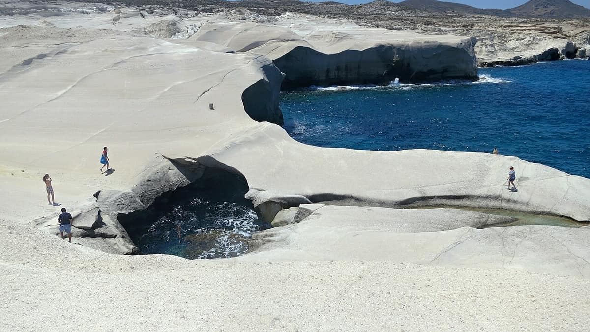
The ledges at Sarakiniko beach sit above open water. Height changes from ledge to ledge, so a low shelf stands beside a tall wall. Jumpers pick a spot they can see from the side. A look from the water shows the rocks below.
Depth changes with the swell and the season. No sign marks the safe spots on the rock. A jumper watches the water for a full minute before a jump. A wave that pulls back shows the ground below.
Nobody jumps alone here. A second person stays on the ledge and watches the water. That person keeps a phone dry and knows the easy way out. Help arrives faster when a friend raises the alarm.
The entry into the water matters as much as the leap. Feet first keeps the head clear of hidden rock. A flat landing on the back knocks the breath out. Cold water also shocks a swimmer after time in the sun.
The north shore takes the swell from the open sea. Waves arrive from the north and push against the cliffs. On a rough day the water inside the inlet churns, and the ledges turn wet.
- Depth: The sea floor changes, so a jumper checks it.
- Company: A second person stays on the rock.
- Surface: Wet stone near the edge takes grip away.
- Entry: Feet first keeps the head from hidden rock.
- Weather: A calm sea and a light wind suit a jump.
A jump at Sarakiniko beach is a choice, not a dare. The rock is hard and the sea keeps moving. Care and a watching friend turn a risk into a story. A swim from the inlet stays the safer plan.
Why does Sarakiniko beach feel so bright in the sun?
Sarakiniko beach looks bright because pale volcanic rock throws sunlight back at the eye. The bare stone carries little plant life, so nothing breaks the glare. Shade is scarce, and the white ground holds heat through the middle of the day.
The rock at Sarakiniko beach is greyish white, and it reflects the light of the sun. A pale surface returns a large share of the sunlight that falls on it. That is why the shore feels brighter than a beach of dark sand.
A couple of trees stand at the back of the beach and give small areas of shade. Away from them the white rock lies open to the sky. A wide hat and dark glasses guard the eyes.
Water matters as much as shade. The dry air and the strong light pull moisture from the body, and thirst arrives late. A full bottle travels well in a small bag. Drinking in steady sips beats one long drink at the end.
The sun stands highest around midday, and the rock holds its heat after that. The hours before noon and late afternoon stay cooler. Visitors who arrive early leave before the glare peaks at Sarakiniko beach.
Sunlight also bounces off the calm sea inside the inlet. A swimmer takes the same glare on the face and the shoulders. Sun cream needs a second layer after a swim, because water washes the first away.
- Light: White rock reflects the sun and doubles the brightness.
- Shade: A couple of trees at the back give small shaded spots.
- Eyes: Dark sunglasses cut the glare from stone and water.
- Skin: A wide hat and sun cream guard the face.
- Water: A full bottle keeps the body working in dry heat.
Bright light shapes a day at Sarakiniko beach. The white stone gives the shore its fame and its glare at the same time. A hat, dark glasses, water and a shaded pause keep a visit comfortable. The cool hours of the morning stay the kindest.
How does light change at Sarakiniko beach through the day?
Sarakiniko beach changes colour with the light. Early light touches the pale rock and leaves long shadows across the stone. Later the sun stands high, the shadows shrink, and the white ground glows. The last light turns the rock warm.
The north shore faces open sea, so light arrives without a hill. At first light Sarakiniko beach takes a soft grey tone. Every ridge and hollow shows in the low sun. Photographers rate this landscape among the best-known in the Aegean.
Morning light moves fast across the rock. Shadows shorten as the sun climbs, and the shapes lose depth. By mid-morning the whole shore stands in flat, even light. Colour fades from the stone as the sun rises.
At the end of the day the light comes in low again. The white rock holds a warm tone, and the blue water turns deeper. Shadows stretch across the ledges and the small inlet. The shore empties as the sun drops.
Cloud changes the picture. A thin layer of cloud softens the light and removes the hard glare. A clear sky gives sharp shadows and strong colour. Wind clears the air and makes distant shapes crisp.
The season moves the light too. In summer the sun climbs high and the days run long. In spring and autumn the light slants and the shore stays quiet. Winter brings lower light and a rougher sea on this north coast.
- First light: Low sun shows every ridge and hollow.
- Midday: Shadows shrink and the white rock turns flat.
- Evening: Warm light returns and the water deepens.
- Cloud: A thin cover softens the glare on bare rock.
- Season: Slanting light marks spring and autumn visits.
Light gives Sarakiniko beach its changing face. The same white stone looks soft at dawn, flat at noon and warm at dusk. A visit at either end of the day shows the shapes at their clearest. The middle hours belong to the glare.
How does a visitor reach Sarakiniko beach by road?
Sarakiniko beach sits on the northern shore, roughly 5 km from Plaka, the chief town of Milos. Cars and buses reach the shore by road. The beach is not organised, so no facilities stand there. The road drops from the plateau villages to the sea.
The distance from Plaka, the capital of the island, is about 5 km. The road leaves the plateau above the harbour and drops toward the north shore. Plaka, Trypiti and Triovasalos stand on that higher ground.
Buses serve parts of Milos, and the summer months bring frequent routes. A passenger buys a ticket on the bus. The island is rugged and hilly, so the roads climb and bend between the villages.
A car gives the freedom to stop on the way. The route from the harbour town of Adamas crosses the rise above the bay. Plaka and the villages near it sit on that high, dry plateau.
The road brings a visitor to the shore. Sarakiniko beach covers a small part of the whole site. The strip of sand lies between the white rock formations and measures 10 metres. The rest of the area is bare rock.
A day out by road can join the shore with the rest of the island. An organised Milos island tour carries a group between the sights. Nobody in the group watches the road. Other activities in Milos pair the rock with the sea.
- Distance: Plaka is roughly 5 km away by road.
- Car: A road serves the north coast and cars reach the shore.
- Bus: In summer, island buses run more often and reach parts of Milos.
- Tickets: A passenger buys a bus ticket on board.
- Villages: The plateau above holds Plaka, Trypiti and Triovasalos.
Road travel makes Sarakiniko beach an easy stop on a day out. The drive from the plateau villages runs a short distance downhill. The bus works for a visitor without a car, and the summer timetable helps. The shore itself stays simple, with sand, rock and open sea.

Can a visitor see Sarakiniko beach from the sea?
Sarakiniko beach looks different from the water. The white rock rises as a wall above deep blue sea. Boats and kayaks pass along the north coast, and the small natural harbour opens between the stones. A camera on the deck catches the whole face of the rock.
Boat trips run around Milos and set off from the harbours at Adamas and Pollonia. A boat reaches beaches that no road serves and slips into sea caves. On the north side it passes the pale rock of Sarakiniko beach from the water.
The small natural harbour sits closed between the rocks. Its water turns green-blue in the shade of the stone. A boat waits outside the inlet or comes in when the sea is calm. Swimmers drop from the deck into deep water.
Sea kayaks follow the same coast at a slower pace. A paddler sits close to the water and reads the rock from below. Waves cut caves into the soft stone along this shore. The kayak route that passes Sarakiniko beach enters the cave mouths.
Wind decides the day on the north coast. In meltemia and north winds the shore takes the force of the open sea. A boat captain then keeps to the sheltered bay. Paddlers start early, before the wind builds.
From the sea the layers of the stone show in bands. White, red, yellow and black rock appear along the coast. The pale stone here stands against blue water. A boat also shows the shape of the inlet.
- Boats: Adamas and Pollonia are the two harbours for sea trips.
- Reach: A boat visits shores and caves that no road reaches.
- Harbour: The inlet holds green-blue water between white rocks.
- Kayaks: A paddler passes close to the rock and the caves.
- Wind: The north wind shapes the route and the timing.
The sea gives Sarakiniko beach a second face. From the water the pale wall lines up with the dark blue sea. The small inlet closes the view. A boat or a kayak reaches the same shore without a road.

How can visitors help protect Sarakiniko beach?
Protecting Sarakiniko beach starts with the rock, which marks easily. Carving a name into the soft stone leaves a scar that lasts for years. The municipality of Milos set a fine in 2015 for pollution of the area. Litter travels home in a bag.
The stone here is soft, and a mark cut into it stays. Names scratched into the white rock have damaged the site, and the island acted against that damage. A fine for pollution of the area came in 2015.
Litter is the second problem. The beach is not organised, so each visitor carries the day’s waste away. A bottle, a wrapper or a cigarette end goes home in a bag. Wind lifts light rubbish and carries it into the sea.
Footsteps also leave marks on the dry ground. Dry plants and stony ground cover the eastern side. That cover grows back slowly. Walkers keep to the firm rock and the worn routes. A new line across the slope opens the ground.
Old carvings belong to the history of the place. Mooring posts for boats remain cut into the stone, and they form part of the site. A visitor looks at them and leaves them as found. Touching those marks wears them down.
Wind and waves already work on the stone. The soft layers hold fossils of shells and sea life. A scratch from a visitor sits beside that natural record. Time shapes the rock, and a name only spoils it.
- Carving: A name cut into the soft rock stays for years.
- Litter: The day’s waste leaves the site in a bag.
- Paths: Walkers keep to firm rock and worn routes.
- Fossils: Shells and sea life lie inside the layers of stone.
- Rule: A fine against pollution of the area came in 2015.
Care keeps Sarakiniko beach in good shape for the next visitor. The rock is soft, the plants are thin, and the waste has nowhere to go. Names stay out of the stone and litter stays in the bag. The landscape then stays as it was found.
What do travellers ask about Sarakiniko beach?
Questions about Sarakiniko beach cover children, footwear, resting places, drones, crowds, wind, the seasons and food. The answers below stay with plain facts about the north coast of Milos. They cover the rock, the water, the weather and the days when the shore stays quiet.
Is Sarakiniko beach suitable for children?
Children can walk on the rock at Sarakiniko beach. The shallow edge of the inlet suits a paddle. The stone is hard and uneven, and the drop to deep water is sudden. A parent keeps a hand on a small child. The white ground also turns hot under the midday sun.
Are swimming shoes needed at Sarakiniko beach?
The rock at Sarakiniko beach is smooth in places and rough in others. Swimming shoes give grip on wet stone and protect the feet from sharp edges and sea urchins. They also help on the walk down to the inlet. Sandals with a firm sole work in the same way.
Is there sand or rock to lie on at Sarakiniko beach?
Sand at Sarakiniko beach forms a thin strip, and that strip measures 10 metres. The beach is not organised, so no sunbeds stand there. Visitors spread a towel on the flat rock instead. The white stone holds heat, so a mat makes the rest easier. Shade at the back stays limited to a couple of trees.
Can drones and cameras be used at Sarakiniko beach?
Cameras suit Sarakiniko beach, because the pale rock and the blue water frame a clear shot. A drone needs care, since the shore holds other visitors and the north coast wind is strong. Low light at either end of the day gives the best pictures. Keep the aircraft away from people.
When is Sarakiniko beach crowded?
Sarakiniko beach draws visitors through the summer, and the middle of the day brings the largest numbers. The landscape ranks among the best-known subjects for a camera in the Aegean, so the shore fills fast. Early morning and late afternoon stay quieter. Spring and autumn bring lighter traffic on the rock.
How do windy days affect a visit to Sarakiniko beach?
Wind changes the sea at Sarakiniko beach. In meltemia and north winds, the island advice points to the bay. A beach on the south side also works. The north shore then takes the swell, and the ledges turn wet. A calm day suits swimming and jumping far better than a rough one.
Are spring and autumn good times for Sarakiniko beach?
Spring and autumn bring softer light and a quieter shore at Sarakiniko beach. The sun stands lower, so the shadows across the rock last longer. The sea keeps warmth after summer, and the air stays mild. A jacket helps in the evening on the open coast. Rain belongs to winter here.
Is there food and drink at Sarakiniko beach?
Sarakiniko beach has no facilities, so nothing is sold on the rock. Water and food travel in the same bag. Mandrakia, a fishing village on the same north coast, has rooms for rent and a restaurant. The plateau villages of Plaka and Triovasalos lie a short drive inland. A stop there fits the drive home.