Route No. 3 covers a distance of 2.1 km and lasts 5-6 hours. We set off from Adamas by car. Crossing western Milos, a designated area protected by Natura 2000, we arrive at Saint John’s Siderianos monastery. We start hiking towards Sykia, the biggest cave on the island of Milos. The path is natural and is considered easy, except for the last 200 metres, where the steep ground makes it slightly difficult. When we arrive at the cave, we explore the surroundings and then take a short break for food and swimming. After resting for a while, we head back, this time by a different path.
Price: 35 euros. Transport, equipment, food and safety are included.
Milos is the south-western island of the Cyclades, a volcanic place of pale rock and salt water, and it lies 120 kilometres from the coast of Laconia. Its western half stands almost empty, and almost all of that land belongs to the Natura 2000 network. A visitor who reads the Milos island pages finds the island set out by area.
This page follows one walk in that western land, the Sykia cave hike Milos route. The walk leaves the port town by road, crosses protected ground, starts at an old monastery and ends above a cave with no roof, where the sea enters and the light falls in. Ground, the steep last stretch, the water inside and the boats below follow.
What does the Sykia cave hike Milos route look like at a glance?
The Sykia cave hike Milos route is a short walk of 2.1 km in the west of the island, from a monastery to the biggest cave of Milos. The ground is natural and easy, apart from the last 200 metres, and the return follows another line.
The day of the Sykia cave hike Milos route begins at Adamas, the harbour town, where the road turns west. The island measures about 23 km from east to west and 13 km from north to south, and the greater part of the western half is rugged and hilly. The road leaves the last houses behind and keeps to a line of low hills until the land opens toward the south-west shore, and the sea shows as a bright band.
The Sykia cave hike Milos route is short in distance. It covers 2.1 km from the starting point to the cave, and the return keeps to another line. A walker leaves the car at the monastery of Agios Ioannis Siderianos, follows a natural path across bare, pale ground, and reaches the rim of a collapsed cave above the sea. The ground underfoot turns from soft dust into loose stone near the end. It is one of the walks of Milos.
The end of the outward walk is the steep stretch. The ground drops for the last 200 metres before the cave, and the slope makes the going slightly difficult. Hands and boots both help on that part. Above it, the walker stands on the broken rim and looks down into a wide opening where the roof has fallen in, and the sea lies in the middle of the hollow. The Sykia cave hike Milos walk turns at this point.
The return makes the walk a circle rather than a line. On the Sykia cave hike Milos route the walker takes a different path back toward the monastery, so the ground of the outward leg is not repeated. That second line keeps to the higher ground, passes low scrub and pale stone, and comes out near the start. The two halves of the walk show the same coast from different heights. The sea stays in sight for much of the way back.
- Distance: The walk covers 2.1 km between the monastery and the cave.
- Start: The walk begins at the monastery of Agios Ioannis Siderianos in the south-west.
- Ground: A natural path crosses bare, pale volcanic ground with little shade.
- Steep stretch: The last 200 metres before the cave drop steeply on loose stone.
- Return: The way back follows a different line over higher ground.
Taken as a whole, the Sykia cave hike Milos route is a short walk with a long view. It starts beside an old monastery, crosses protected ground and ends above a cave that the sea has hollowed out. The distance stays small, but the ground asks for care at the end, and the return keeps the same coast in sight from a second line.
How does the drive into the west begin the Sykia cave hike Milos day?
The Sykia cave hike Milos day begins with a drive from Adamas, the port town, across the western half of the island. The road crosses a protected area with no villages on it, past dry hills, before it reaches the monastery where the walking starts.
Adamas is the harbour town and the main point of arrival by sea. The Sykia cave hike Milos drive leaves it and passes the villages of the bay before the houses stop. From there the ground is open, volcanic and dry. The whole of the uninhabited west belongs to the Natura 2000 network, an area that covers almost the entire western region, and that status shapes the road that crosses it. A boundary sign marks the change.
The surface of the drive changes from asphalt to dirt. A dirt road of about 12 kilometres leads toward the western shore, and the last part of it runs between low hills and open ground. On the Sykia cave hike Milos day the road passes the monastery of Agia Marina on a hill above the gulf, then keeps on toward the monastery of Agios Ioannis Siderianos, where the walker leaves the car behind. The land on both sides belongs to the protected zone.
Volcanic rock decides the look of the west. Tuff, trachyte and obsidian lie among the ordinary rocks of the island, and the west shows them in pale walls, dark grains and dry dust. Volcanic activity on Milos began two to three million years ago, and the last eruption came about 90,000 years ago. The volcano is counted as dormant, so the ground that the Sykia cave hike Milos drive crosses is old, quiet and worn.
There are no villages on the western side of the island. The land holds worked ground, low scrub and tracks, and the only permanent marks are the old workings, chapels and the dirt roads. Because of that, the drive is a quiet part of the Sykia cave hike Milos day, with long views. A track ends near the monastery, and from that point the walking takes over from the driving. The western shore carries more coves beyond the walk, from Agkathia and Kalogries up to Vani.
- Start: The drive starts at Adamas, the harbour town of the island.
- Protection: Almost all of the empty west lies inside the Natura 2000 network.
- Surface: The last part of the road is dirt and runs between low hills.
- Distance: A dirt road of about 12 kilometres reaches the western shore.
- Landmarks: The monasteries of Agia Marina and Agios Ioannis Siderianos stand beside the way.
The drive west sets up the Sykia cave hike Milos day. It takes the walker out of the harbour town, across protected ground, past a monastery and along a dirt road of about 12 kilometres. The rock under the wheels is the same rock that will lie under the boots, and the empty land is the reason the second half of the day stays quiet.

What marks the monastery of Agios Ioannis Siderianos on the Sykia cave hike Milos route?
The Sykia cave hike Milos route begins at the monastery of Agios Ioannis Siderianos, which stands at Halakas above the south-west shore of Milos. Its name, its feast day custom and a shell in its wall belong to the story of the place.
The monastery stands at Halakas, on a hillside above the bay of Agios Ioannis, in the south-west part of the island. It is a small white building in a bare landscape, and it is the last built thing on the road before the shore. The bay below carries the name of the monastery, and the three beaches along it take their name from the same source. The Sykia cave hike Milos route starts at the door of this building.
The name Siderianos comes from iron, and a tradition explains it. On the feast day of the saint, pirates came to the shore, and the people shut themselves inside the church and asked for help. The door held as if it were iron, and the raiders failed to open it. One lost the use of a hand, and the weapon left behind is still kept inside the church. The Sykia cave hike Milos walker passes that same door.
The feast day of the saint is the day of that tradition, and the church keeps the memory of it in the objects left behind. The building itself is small and old, and it stands on open ground above the sea. A shell from the Second World War struck the wall and failed to explode, and the mark of the strike can still be seen on the stones. The Sykia cave hike Milos day starts at that door.
The road that passes the monastery runs on to the beach of Agios Ioannis and then to Ammoudaraki and the three beaches of Triades. That road is a dirt track, and it holds no house, no shop and no sign of a village. A walker who arrives early finds the ground cool and the light flat, and the walk to the cave starts from there. The Sykia cave hike Milos route leaves the buildings and turns toward the open country.
- Place: The monastery stands at Halakas, above the bay of Agios Ioannis.
- Name: The name Siderianos is tied to iron and to a pirate raid.
- Feast: The feast day of the saint is the day of that tradition.
- Wall: A shell from the Second World War struck the church and failed to explode.
- Start: The walk to the cave begins at the door of the monastery.
The monastery gives the Sykia cave hike Milos route its starting point and its first story. A small church, a name tied to iron and a shell that never exploded all stand on the same hill above the bay. From the door the path turns away from the buildings toward the open ground, and the sea stays below the walker for the rest of the way.
What is the ground like on the Sykia cave hike Milos path?
The Sykia cave hike Milos path runs over bare volcanic ground on a natural line with loose dust, pale stone and low scrub, and it turns steep for the last 200 metres before the cave. Sturdy shoes and a full water bottle belong in the day pack.
The path is a natural line rather than a built track. For the greater part of its length the Sykia cave hike Milos path crosses open ground where the rock lies close to the surface and the covering of soil is thin. Low scrub grows in patches, and pale stones lie loose on the surface, so the foot rolls a little on the way out. There is no wall, no fence and no marking on the ground.
The last 200 metres decide the character of the Sykia cave hike Milos walk. The ground falls away toward the cave, the slope steepens, and the surface turns to loose stone and broken rock. Steps get shorter and the arms come into use on the steeper faces. The stretch is short but it asks for care, and wet or windy weather raises the risk on that part. The rest of the path below it stays easy.
Footwear matters on ground of this kind. Hiking boots protect the feet and the ankles, and a stiff sole holds on loose stone. Light shoes with thin soles give nothing back on rock, and the steep stretch punishes them. Walkers take poles for balance. An ankle sprain is the common injury on walks of this sort, and the support of a boot lowers the chance of one. On the Sykia cave hike Milos route socks with no folds help as well.
Water and heat shape the Sykia cave hike Milos day. The mean daily maximum on the island reaches 28.1 degrees Celsius in July, and the record high of 44.0 degrees was set in June. July brings 0.3 mm of rain, and mean relative humidity stands at 58.8 percent in June. Two litres of water suit a short walk in mild weather, and hot conditions ask for more. Sun cream and a hat cover the rest.
- Ground: The path crosses bare rock, thin soil and loose pale stone.
- Steep stretch: The last 200 metres descend toward the cave over broken rock.
- Footwear: Boots with stiff soles and ankle support suit the ground.
- Water: Two litres serve a short walk, and heat asks for more.
- Weather: July brings 0.3 mm of rain and a mean high of 28.1 degrees.
Ground, distance and water decide the Sykia cave hike Milos day more than anything else. The line is natural, the surface is loose in places, and the steep stretch at the end asks for steady feet. A hat, a full bottle and boots with ankle support answer the ground. Nothing on the path is built, so the walker reads the way from the wear of other feet.
What does the Sykia cave hike Milos route show at the cave itself?
The Sykia cave hike Milos route ends above the biggest cave on Milos, a hollow whose roof has fallen in. Sunlight enters through the open top and lights the water below, which turns emerald in the middle of the day.
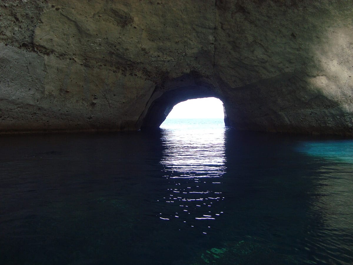
The cave opens in the rock above the sea, and its roof has collapsed. What remains is a wide bowl with walls on three sides and an opening to the water. The rocks around it are pale, and the rim is broken into blocks and ledges. From the top the floor of the hollow lies far below, and the sea fills the middle of it. The Sykia cave hike Milos route stops two steps from the edge.
Light gives the cave its character. With no roof over the water, the rays of the sun enter from above and fall straight on the surface, and the water inside turns emerald. The colour changes through the day as the sun moves, and the walls throw the light back. In the morning the shade holds the far side of the bowl, and at midday the whole floor is lit. The Sykia cave hike Milos walk pauses at the rim for this view.
Sykia is the biggest cave of the island. Its mouth faces the open sea, and the hollow behind it runs back into the rock, so a boat that enters the opening passes under high walls. The scale shows best from the water, where pale rock rises on both sides and the top stands open to the sky. Above the waterline the walls keep a dark band, and the Sykia cave hike Milos day ends with that picture.
The cave belongs to the same volcanic story as the rest of the west. Waves cut at the base of the walls, salt opens the joints in the rock, and the softer beds give way first. In the end the roof of the hollow lost its support and fell into the water below. What remains is the open bowl that the Sykia cave hike Milos walker sees from the rim, with the sea still working on it.
- Roof: The roof of the cave has fallen in, so the top stays open.
- Light: Sunlight enters from above and falls on the water inside.
- Water: The surface inside the cave turns emerald in the daylight.
- Size: Sykia counts as the biggest cave on the island of Milos.
- Walls: Pale rock walls stand on three sides of the open bowl.
The cave is the centre of the Sykia cave hike Milos day. A walker sees it first from above, as an open bowl with the sea in the middle, and then meets it again from the water if the day includes a swim. The roof is gone, the light falls straight in, and the size shows from below. Distance and ground finish their work here, and the cave takes over.
Where does a swimmer enter the water on the Sykia cave hike Milos day?
The Sykia cave hike Milos day leaves time for a swim. The water inside the cave is reached from the sea, and the beaches of Agios Ioannis, Ammoudaraki and Triades lie along the same western shore, one after the other, below the track.
Swimming at the cave happens from the water side. The cave is reached from the sea, so a swimmer arrives at the mouth by boat and then moves into the shadow of the walls. Inside, the water is deep enough to swim over and the light comes down from the open top. On the Sykia cave hike Milos day the surface stays calm while the walls block the wind. A day that pairs the walk with snorkelling has its own combined route.
The shore below the monastery offers the second option. The beach of Agios Ioannis is divided into three parts joined by paths, and the first of the three can be reached by car. The other two ask for a walk and a climb down the rocks. The name of the beach comes from the monastery, so entry from the sand is simple. A dirt road of about 12 kilometres runs out to the Sykia cave hike Milos shore.
Triades holds three coves set one behind the other among rocks, and Ammoudaraki lies beside them. The sand in that group is fair and soft, and the water stays shallow close to the edge before it deepens. Reaching the group takes a long drive over rough ground, so the shore stays quiet. A swimmer who makes the trip finds shelter from the wind behind the rock walls. The Sykia cave hike Milos day can end at this shore after the walk.
Care belongs in the water as much as on the path. The coast of the west faces open sea, and the wind can raise waves along it in a short time. Rock walls drop straight into deep water in places, so a swimmer stays with the group and keeps away from the swell. A mask helps in the clear water. The Sykia cave hike Milos route stays dry at the end, and the swim is a separate choice.
- Cave water: The water inside Sykia is reached from the sea by boat.
- Agios Ioannis: The beach below the monastery splits into three parts joined by paths.
- Access: The first part of that beach can be reached by car.
- Triades: Three coves lie one behind the other among rocks.
- Shelter: Rock walls block the wind at these western coves.
A swim closes the Sykia cave hike Milos day well. The cave offers the first chance, with calm water under an open roof. The beaches of the west offer the second, in three parts at Agios Ioannis, in three coves at Triades and along the shore at Ammoudaraki. All of them lie below the same dirt road, and all stay quiet because the drive is long.
Which boats pass the Sykia cave hike Milos shore along the south-west coast?
Boats pass the Sykia cave hike Milos shore along the south-west coast of the island. Boats leave from the ports of Adamas and Pollonia, travel the western side, call at the cave, and carry visitors who wish to see the same coast from the water.
Sea trips leave the harbour of Adamas and the port of Pollonia through the day. A boat that turns west follows the coast under the cliffs, passes coves that no road reaches, and comes to the mouth of the cave. Excursions of this kind are the way to reach shores that stay closed to walkers, and they also give the whole view of the coast from the water. The one day cruises from Adamas follow this coast.
The line of the coast tells the story of the west. From the water the cliffs stand high and pale, with dark bands at the waterline and open rock above. Boats pass the caves at Kleftiko, where sheer white volcanic rock rises in a group from the sea. The Sykia cave hike Milos shore is the same shore seen from below, and the two views fit together. Boats of shallow draught enter the openings in the rock.
A stop at the cave is the middle of the day. The boat waits outside the mouth while swimmers move into the emerald water under the walls, and the light from the open roof follows them in. Then the trip turns toward the rocks of Kleftiko, where diving from the boat and the rock ledges fills the afternoon. The Sykia cave hike Milos day from the water ends with the same coast in sight on the way back.
The two ways of meeting the cave give two different pictures. From above, the rim frames an open bowl with the sea at the bottom. From the sea, the walls rise on either side and the opening in the top shows as a ring of sky. Walkers who see both get the shape of the cave and the shape of the coast. The sight from the water closes the circle that the Sykia cave hike Milos route opens on land.
- Ports: Boats leave from the harbour of Adamas and the port of Pollonia.
- West coast: Sea trips pass coves and cliffs that no road reaches.
- Caves: The rock group at Kleftiko rises sheer and white from the water.
- Cave stop: Boats wait at the mouth of Sykia while swimmers enter.
- View: The walls of the cave rise on either side of the opening.
The sea gives the cave a second entrance and the coast a second reading. Boats leave the two ports of the island, follow the western shore under the cliffs, stop at the mouth of Sykia and go on to the rocks at Kleftiko. The water below the Sykia cave hike Milos walk shows the same pale rock that the path crosses above, and the emerald water is the reward.


What other places of the west lie near the Sykia cave hike Milos route?
Places near the Sykia cave hike Milos route include the rock group at Kleftiko, the coves of Triades and Ammoudaraki, and the highest ground of the island. All of them lie in the same empty western half, inside the protected area.
Kleftiko is the best known landmark of the west. It is a group of white volcanic rocks that stands in the sea at the south-western corner of the island, with caves cut into the stone and water deep enough for diving. No road serves the place, so it is seen from a boat. The caves there give shelter to boats and swimmers, and the Sykia cave hike Milos route looks out on the same sea.
The coves of the west line up along the same shore. Below the monastery the beach of Agios Ioannis splits into three parts, and Ammoudaraki lies next, followed by the three coves of Triades. The drive out to them is long, so the shore stays quiet, and the ground around them is dry and bare. The Sykia cave hike Milos route crosses the land above them, and paths and rock steps lead down to the sand.
The highest ground of the island stands in the west. Mount Profitis Elias reaches 751 metres, and Chondro Vouno follows at 636 metres. Both rise from the same rough country that the Sykia cave hike Milos walk crosses at a much lower level, and both show the shape of a volcanic island. The island measures about 23 km from east to west, and the two summits stand in the western part of that line. The walk stays well below these heights.
The protected area gives the west its other value. Almost the whole uninhabited western region is a Natura 2000 site, and it holds over 800 different taxa, of which 35 are endemic to Greece. Dry ground, sea cliffs and open slopes make the setting for that life. The walker who crosses the Sykia cave hike Milos land on foot moves through a reserve rather than a park, and the quiet of the place belongs to the same protection.
- Kleftiko: White volcanic rocks with caves stand in the sea off the south-west corner.
- Triades: Three coves lie one behind the other among rocks.
- Ammoudaraki: Fair soft sand lies beside the coves of Triades.
- Summit: Mount Profitis Elias reaches 751 metres at the highest point of Milos.
- Reserve: The western region holds over 800 taxa, 35 of them endemic to Greece.
The west holds more than one destination, and the walk to the cave sits among them. Kleftiko fills the sea corner with white rock and caves, the coves of Agios Ioannis, Ammoudaraki and Triades line the shore, and Mount Profitis Elias raises the highest ground over the same land. The Sykia cave hike Milos route takes a single line through the middle of all of it.

What else do walkers ask about the Sykia cave hike Milos route?
The Sykia cave hike Milos route raises the same questions each season. Walkers ask how far it runs, where it starts, whether the cave is reached on foot, why the roof is missing, which month suits the ground, and what belongs in the day pack.
How far is the Sykia cave hike Milos route?
The walk covers 2.1 km between the monastery and the cave. That figure counts the walking only, not the drive from Adamas into the west. The outward line and the return line differ, so the ground underfoot changes on the way back. The distance stays small, and the ground, rather than the metres, sets the pace.
Where does the Sykia cave hike Milos route begin?
The walk begins at the monastery of Agios Ioannis Siderianos at Halakas, in the south-west of the island. Cars arrive by road from Adamas, and the walking starts at the door of the building. From there the path crosses bare ground toward the cave. The Sykia cave hike Milos route starts where the road ends.
Is the cave reached on foot on the Sykia cave hike Milos route?
The walk arrives at the rim of the cave from above, and the opening lies below the last steep stretch. The water inside is reached from the sea, which is how the cave is entered. A walker who stays on land sees the bowl, the fallen roof and the light on the water from the edge.
Why is the roof missing on the Sykia cave hike Milos cave?
The roof of the cave has fallen in, so the top of the hollow stands open to the sky. The fall is a result of the sea working at the base of the rock, where waves and salt open the joints and carry the softer beds away. With the top open, sunlight reaches the water and turns it emerald.
Which month suits the ground on the Sykia cave hike Milos route?
Spring and autumn give the mildest days on the paths of the island. April has a daily mean of 15.2 degrees Celsius, and September brings 22.3 degrees. June, July and August record 0.3, 0.1 and 0.1 rainy days, and July holds a record high of 41.0 degrees. A short walk in the west suits the shoulder months best.
What does a walker carry on the Sykia cave hike Milos day?
Water comes first, and two litres suit a short walk in mild weather. Boots with stiff soles and ankle support answer ground that is loose in places, and a hat and sun cream cover the skin on open slopes. A mask belongs in the bag if the day includes a swim along the western shore.
What protection covers the land on the Sykia cave hike Milos route?
Almost the whole uninhabited western region of the island belongs to the Natura 2000 network. That ground holds over 800 different taxa, and 35 of them are endemic to Greece. Dry hills, sea cliffs and open slopes make the setting for that life. The protection does not close the land to walkers, and the route stays open.
Where does the day end after the Sykia cave hike Milos route?
The day ends where the walking ends, at the monastery in the west. From there the car takes the same dirt road back toward the harbour town. A swim at one of the western coves fits before the drive, and the last part of the road runs with the sea on the right. Evening brings the lights of the harbour.