
Gerontas beach lies on the far south-west shore of the island of Milos. Milos belongs to the Cyclades. The beach is a cove, meaning a curved bay closed in by rock. White cliffs and caves wrap around it. Its sand is dark, and its water is a clear blue-green.
Gerontas beach is the farthest of the south beaches that a car can reach. A dirt road leads toward it, and the last stretch is a walk. This page first gives a plain portrait of the place. It then shows where the cove sits on the island.
What is Gerontas beach like at a glance?
Gerontas beach is a rocky cove on the far south-west coast of Milos. White cliffs and caves close around it. The sand is dark, and the water is clear and turquoise. One rock arches like a bridge from the sea onto the land.
Gerontas beach belongs to the south side of Milos. Volcanic activity created this island. Its southern shore looks out toward the Sea of Crete. A cove like this one is a bay where rock curves around the water. Here, that rock is white and towers over the sand.
At Gerontas beach, the colours sit in sharp contrast. White rock rises around the bay, and caves open in its face. Dark sand lines the shore below that pale wall. The sea in front is turquoise, a mix of blue and green, and it is clear.
A rock at the cove has the shape of a bridge. It forms a span of stone that links the sea with the land. This bridge of rock is the main landmark of the bay. The water around it is clear and clean.
Reaching the cove takes real effort. The road toward it is a dirt track, not a paved road. Once the car stops, the last stretch is on foot. The track and the walk make access fairly hard. Later sections explain the land and sea routes in detail.
The south side of Milos alone holds 21 beaches. Across the island, land routes reach a share of the beaches. Others are open only from the sea. Gerontas beach falls in the first group, because a car can get close to it. Even so, it stays isolated, far from any village.
- Type: It is a cove ringed by white rock and caves.
- Sand: The shore is covered in dark sand.
- Water: The sea is clear and turquoise.
- Landmark: A stone bridge stands where the water meets the shore.
- Access: A dirt road and a walk lead to the shore.
Put simply, Gerontas beach is a cove of white rock at the far end of the south shore. Dark sand and turquoise water fill the space between the cliffs. A stone bridge gives the bay its main landmark. A rough road and a walk on foot lead the way in.

Where does Gerontas beach lie on Milos?
Gerontas beach lies near the west end of the south coast of Milos. Going from east to west along that shore, it is the second-last beach. Katergo comes just before it, and Kleftiko comes just after it, closing the row.
Milos lies at the south-west corner of the Cyclades. The Cyclades are a group of Greek islands in the Aegean Sea. The outline of Milos looks like a horseshoe. A large bay enters from the north-west. It divides Milos into two halves of roughly equal size.
Gerontas beach sits on the south shore of the western half. That shore holds one long chain of the beaches of Milos. Read from east to west, the chain starts at Psarovolada. It ends at Kleftiko, and this cove is the stop just before that end.
Only Kleftiko lies west of the cove on the south side. Past Kleftiko, the shore turns and becomes the west coast. Its beaches run from south to north, and the first one is Akrotiri Psalida. So Gerontas beach sits close to the corner where the south and west coasts meet.
Wild country fills the western half of the island. This part holds no villages. A handful of settlements and a scatter of old mines are all that stand there. The top peak of the island, Mount Profitis Elias, rises in the west. Gerontas beach lies at the sea edge of this uninhabited land.
Almost all of western Milos is a Natura 2000 site. That is a network of protected nature areas across Europe. Over 800 kinds of plants are found there, and 35 of them are native only to Greece. The south-west side is also home to the Mediterranean monk seal.
- Coast: The beach lies on the south shore of Milos.
- Order: It is the second-last beach from east to west.
- Next door: Katergo lies to the east, and Kleftiko lies to the west.
- Area: The western half around it has no villages.
- Nature: Almost all of the west is protected under Natura 2000.
In short, Gerontas beach sits one step before Kleftiko, near the far end of the south shore. Behind it spreads the uninhabited western half of Milos. That land holds protected nature but no villages, and seals live along its south-west shore. This setting is what makes the cove so remote.
What rocks and colours surround Gerontas beach?
Gerontas beach is a cove held inside tall white rock, with caves in its walls. The beach sits on an island built by volcanoes. Volcanic rock covers the larger part of that land. Its stone shows how fire, ash and the sea shaped Milos.
At Gerontas beach, white rock wraps around the cove and opens into caves. One rock stands apart from the rest of the white walls around the bay. Its form is that of a bridge, reaching out from the water to the dry shore.
The volcanoes of Milos first woke between 2 and 3 million years ago. Their last eruption came 90,000 years ago. Yet Milos counts as dormant rather than dead, so it keeps the power to erupt again.
Tuff, a fairly soft stone, counts among the ordinary rocks found all across Milos. Tuff begins as volcanic ash, thrown out of a vent during an eruption. The fallen ash then sets hard, sometimes quickly, and turns into solid stone.
Newly cooled volcanic ash holds a large share of tiny bits of natural glass. This glass is unstable and reacts fast when it meets groundwater or seawater. New minerals, such as clays, then grow from it and bind the loose grains into firm stone.
Across Milos, the rocks show shades of white, red, yellow and black. Time and the sea have carved them into odd shapes along the coast. Because of this varied rock, each beach on the island looks different from the next.
- White walls: Tall white rock and caves enclose Gerontas beach.
- Bridge rock: A stone bridge links the shore with the sea.
- Tuff: Volcanic ash that settles and turns solid.
- Lava domes: Kastro, above Plaka, is a hardened dome of lava.
- Melian earth: Ancient artists painted with this white earth from Milos.
Gerontas beach shows one face of an island made by eruptions over millions of years. Milos holds two extinct volcanoes, and Trachilas in the north-north-west is one of them. The other, Firiplaka, shares its name with Firiplaka beach, further east on the same south coast.
What are the sand and the water like at Gerontas beach?
Gerontas beach has a shore of dark sand set below pale rock walls. The sea in its cove is clear and turquoise, a shade between blue and green. Dark sand, white stone and bright water give the place three strong colours.
Visitors who reach Gerontas beach step onto a shore of dark sand. The sand lies in a cove enclosed by tall, imposing walls of white rock. Dark grains below and light stone above set the two colours side by side.
Dark sand at Gerontas beach is not the only dark material on Milos. Obsidian, a black natural glass, is one of the common rocks of the island. It forms when rhyolite, a type of lava, cools very fast and freezes solid.
Cooled slowly, the same lava becomes rhyolite, a light-coloured solid rock. Full of gas bubbles, it turns into pumice, a spongy stone. So one lava can end as black glass, pale rock or pumice, based on how it cools.
The sea at Gerontas beach is clean and clear, a point the cove is known for. Its colour sits between blue and green, the shade called turquoise. The bridge-shaped rock stands in this bright water and reaches across to the dry land.
Milos still holds heat deep under its ground and under its sea floor. In places, gas from deep inside the Earth rises through the seabed and reaches the surface as bubbles. Hot springs on the island also reach temperatures of up to 55°C.
- Sand: Dark sand lines the shore below pale rock.
- Water: The sea is clean, clear and turquoise.
- Grain size: Volcanic ash grains measure under 2 mm, the size of sand or smaller.
- Summers: Milos has warm to hot, dry summers.
- Steam: Steam has been found 1,100 metres below Milos.
Gerontas beach pairs dark sand with clean, clear turquoise water and walls of white rock. On Milos, black obsidian and the pale volcanic stone of the coast both came from eruptions. Beneath the sea, the island still keeps a store of heat that sends up gas bubbles.
What is the coast around Gerontas beach like?
Gerontas beach sits on a rugged part of the south coast, where white rock meets the sea. Caves and tunnels run through this volcanic shore. Further east along the same coast, vents and hot springs still show heat from below.
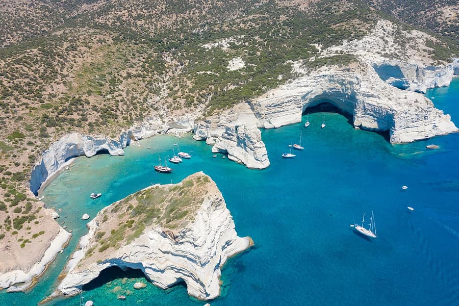
Around Gerontas beach, high white rock forms the edge of the land, and caves open in its face. Walls and hollows like these mark the coast of Milos. The volcanic past of the island shows clearly in its caves and in the shapes of its shoreline.
Because Milos is made of volcanic rock, its shoreline is full of sea caves and tunnels. A tunnel here means a passage that runs right through the rock. These openings make the coast a place to explore from the water, by sea kayak.
The south coast, home to Gerontas beach, still holds heat from the volcano. Inside one of its caves, the warmth is still strong. Further east along this shore, gas vents at Agia Kyriaki and Paleochori reach as high as 100°C.
Sulphur is plain to see in the ground around these vents. In ancient times, no place in the known world gave more sulphur than Milos. Hot springs also flow on the south side, at Paleochori and at the baths of Provatas.
Rough, hilly ground covers the larger share of Milos, and its highest land lies in the west. Profitis Elias, its highest summit, is a volcanic dome, made of lava that set before it poured out. Such domes are made mainly of andesite, a rock formed from lava.
- Kleftiko: Its grey and white rocks hold caves made by wind and sea.
- Beach count: At least 90 beaches ring Milos, and 21 of them lie on the south side.
- Sulphur mining: Mines on Milos dug sulphur until the mid-20th century.
- Chondro Vouno: This western peak, at 636 metres, ranks second on Milos.
- Gerontas beach: Its white rock cove lies near the far west of the south coast.
Gerontas beach sits on a coast of white rock, sea caves and hidden heat. East of it, warm vents and springs dot the shore, while caves fill Kleftiko to the west. The whole stretch shows how volcanoes, time and the sea shaped the southern side of Milos.
How do visitors reach Gerontas beach by land?
Gerontas beach is the farthest south beach that a car can reach on Milos. Access is fairly hard, because the way in is a dirt road. At the end of the drive, a walk on foot covers the last stretch to the sand.
The road to Gerontas beach heads into western Milos, where the land is at its wildest. There are no villages there, only a scattering of small settlements and disused mines. The only working mine, at Xylokeratia, digs pozzolana, a volcanic ash that the Romans used in concrete.
No island in the Cyclades has a bigger web of dirt roads than Milos. These tracks run to coastal spots, country chapels and mines, and certain stretches are very rough. Western beaches are isolated, so the drive to Gerontas beach covers a real distance over open ground.
A dirt road has no asphalt or stone on top and uses the local ground instead. Depending on the place, it is sandy, stony, rocky or plain earth, and it is rarely levelled. Passing wheels push the loose soil into small ridges, so a car shakes and bumps along.
A narrow dirt track suits a small vehicle better than a large, wide one. Wet ground turns muddy and slippery, while dry ground bakes hard in the sun. After heavy rain, even off-road vehicles cannot always pass, so Gerontas beach is a dry-day trip.
Visitors without a car of their own face a narrower choice for this trip. City buses serve only certain parts of Milos, not every corner of the island. The island has 15 taxis in all, found at the harbour and at the airport.
- Region: The western half of Milos has no villages at all.
- Nature: Almost all of the west is a protected Natura 2000 site.
- Roads: Milos has the biggest dirt-road network of the Cyclades.
- Rain: Heavy rain can close a dirt road even to off-road vehicles.
- Last stretch: The car stops short of the beach, and the rest is on foot.
The trip to Gerontas beach by land has two parts. A car handles the dirt road, and a walk on foot covers the final stretch. The walk ends in a cove of white rocks and caves, with dark sand by the water.
Can visitors reach Gerontas beach by sea?
Gerontas beach can also be reached from the sea. Boat trips leave the ports of Adamas and Pollonia and travel along the coast of the island. Visitors who want to steer for themselves can rent a small boat and choose their own stops.
Sea trips around Milos stop at beaches that have no road at all. Gerontas beach does have a dirt road, yet the sea gives it a second way in. On these trips, passengers swim in clear water, explore caves and see the mineral wealth of Milos.
Three kinds of craft run these trips around Milos: excursion boats, caiques and sailboats. A caique is a traditional Aegean fishing boat with a wooden hull and a short mast. Each traveller picks the craft that matches personal needs and the mood of the day.
Adamas, the main port, lies on the big gulf that cuts into the middle of Milos. This gulf fills the hollow of the main volcanic crater and opens to the north-west. Pollonia, a second and smaller harbour, mainly serves the crossing to Kimolos next door.
The south-west coast around Gerontas beach is home to the Mediterranean monk seal. It is thought to be the rarest seal anywhere in the world. These shy animals now rest and give birth in sea caves, away from contact with people.
Another option is a Milos boat rental, where the visitor steers a small boat along the coast. The stops and the pace along the south-west shore then stay in the visitor’s hands. Gerontas beach then becomes one stop on a day spent among the coves of that coast.
- Ports: Sea trips start mainly from Adamas or from Pollonia.
- Craft: Excursion boats, caiques and sailboats all carry passengers.
- Neighbour: Kleftiko is the next beach west of Gerontas on the south shore.
- Heat: A cave on the southern shore still holds warmth from the volcano below.
- Rental: A hired boat can be a motorboat or a sailing craft.
By sea, Gerontas beach is one stop on a coast of white rock and caves. Sea trips leave from Adamas or Pollonia, while a rented boat leaves the route to the visitor. Either way, the boat takes the place of the dirt road and the drive across the west.

What lies west of Gerontas beach, at Kleftiko and the wild west end?
Gerontas beach is the farthest beach on the south coast that a car can reach. West of it, the shore belongs to boats. Kleftiko waits at the far end of that coast. Behind it spreads the western half of Milos, the island’s wildest and emptiest part.
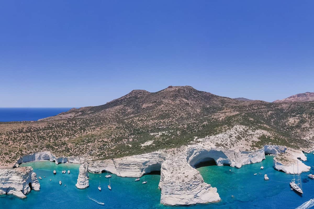
Wild land fills the western half of Milos. No villages stand on that side of the island. A scatter of tiny settlements and old mines breaks up the bare hills. Just one of those mines still works, at a place called Xylokeratia. Gerontas beach sits on the southern rim of this empty land.
Nearly all of this western land falls under Natura 2000, a European scheme that protects wild nature. More than 800 kinds of plants grow there. Of these, 35 grow wild only in Greece. A rare migrating falcon is among the protected birds of the area.
The southwest side of Milos is a home for the Mediterranean seal. Elsewhere in the west lives the Milos viper, a kind of snake, along with a lizard. A forest of cypress trees with flat, sideways branches grows there as well. Its trees have stood for centuries.
Kleftiko is a cluster of grey and white rocks standing in the sea. Over the centuries, wind and waves have carved caves and hollows into them. Pirates once used the spot as a hideout and base. The name comes from them. Visitors come by sailing boat or on a Kleftiko boat tour.
Gerontas beach is the last stop on the south coast before Kleftiko. The west side of the island holds 15 more beaches. All of them feel remote. Across Milos, part of the coast is open by land. The rest is open only by sea.
- Villages: None stand in the western half, only tiny settlements and old mines.
- Nature: Almost the whole west is protected as a Natura 2000 site.
- Wildlife: Seals use the southwest side, and the Milos viper lives in the west.
- Kleftiko: Its grey and white rocks and sea caves are reached by boat.
- Highest point: Profitis Elias, the highest peak on Milos, rises in the west.
Gerontas beach marks the point where the road gives way to the sea. Beyond it lie empty hills, protected land and the caves of Kleftiko. A visit to Gerontas beach is a first look at this wild corner of Milos.
When is the right time to visit Gerontas beach?
Gerontas beach suits the summer north wind, because it lies on the south coast. That wind, the meltemi, blows from late spring to mid-September. Summer is also the busy season on Milos. Spring and the weeks after the wind fades bring calmer seas and fewer people.
The meltemi is a strong, dry wind. In summer it pours down the Aegean from the north. Over the middle of the sea it comes straight from the north. Further south, toward the Sea of Crete, it swings round to the north-west. Milos lies just north of that sea.
Beach advice on Milos follows the wind. On north-wind days, the bay is a good choice. The south coast is better still. Gerontas beach lies on that south coast. The hilly island stands between the north wind and the cove. The water there stays calmer.
The meltemi builds through the day and peaks in the afternoon heat. At night it tends to drop. Strong gusts in the hottest hours can keep small boats in port. Kleftiko is open only to boats. So a windy day suits Gerontas beach better than a sea trip west.
Summer brings the largest flow of visitors to Milos. Boats set off every day from Adamas and Pollonia. The west end shares in that traffic. Even at its peak, the island stays less crowded than Santorini or Mykonos.
Spring and autumn sit at the edges of the wind season. Light north winds come first, in late spring, and then pause in June. The full meltemi follows and fades from mid-September, gone by early October. Winters on Milos are mild and wet. The warm months suit Gerontas beach best.
- North wind: Gerontas beach sits on the sheltered south coast.
- South wind: The north coast becomes the better place to swim.
- Afternoon: The meltemi is at its strongest and can keep small boats in port.
- High summer: Milos is at its busiest, with boats leaving port daily.
- Spring and autumn: These seasons fall outside the full meltemi and bring quieter days.
Gerontas beach is the south-coast answer to a windy summer day. A boat trip to Kleftiko needs a calmer sea, ideally in the morning. Late spring and the weeks after mid-September offer both calm water and a quieter island to explore.
How does a visitor stay safe at remote Gerontas beach?
Gerontas beach is the last south-coast beach that a car can get near. A dirt road leads most of the way, and a walk on foot covers the rest. Safety rests on water, sun cover, firm shoes and a plan that someone in town knows.
Milos has warm to hot, dry summers. The drive and the walk to the cove add effort in that heat. The body loses water through heat and exercise. A large loss of body water brings tiredness and dizziness.
Sunburn comes from too much ultraviolet light, mostly from the sun. The skin turns red, hot to the touch and sore. A wide hat, a loose top and sun cream protect the skin on the sand. Shade on a small cove cannot be counted on, so visitors carry their own.
Heatstroke is the more serious danger on a hot day. Its signs include cramps, red and hot skin, no sweat, and dizziness or fainting. A person with these signs needs shade, cooling and quick help from others.
The way in starts on a dirt road, so a car moves slowly and stops on firm ground. The last stretch is a walk on foot. Shoes with a firm grip suit the track and the rocks by the water. Bare feet and flip-flops slip on dust and stone.
Before the drive, a friend or the host hears the plan. The plan names the beach and the hour of return. Phone coverage along a remote cliff coast is not something to rely on. A charged phone and a small first aid kit still go in the bag.
- Water: Each person carries enough to drink for the drive, the walk and the swim.
- Sun: Sun cream and a hat cover exposed skin.
- Shoes: Firm soles with grip suit the dirt track and the rocks.
- Plan: Someone in town knows the beach and the hour of return.
- Caves: Swimmers keep clear of the caves and rocks when waves rise.
Gerontas beach rewards a careful and simple visit. Water, sun cover, firm shoes and a shared plan deal with the main risks of a remote cove. The same habits serve well at Tsigrado beach, which lies further east on the same coast.
Which beaches lie near Gerontas beach on the south-west coast?
Gerontas beach has Katergo as its neighbour to the east and Kleftiko to the west. Further east lie Akrotiraki, Psathi, Tsigkoulia and Kipos, in that order. These seven names close the list of beaches on the south side of Milos.
The south side of Milos has a long list of beaches, named from east to west. Gerontas beach comes second to last in that line. Only Kleftiko lies further west, at the very end of the coast.
Katergo is the next beach to the east. White rock formations light up the shore around it. Huge caves in a mix of colours open in the cliffs nearby. Kayak groups on this stretch stop at Katergo beach for food and a swim.
Psathi is a small beach further east. Two small, colourful beaches with untouched shores lie close to it. Between Psathi and Katergo, orange and beige rock gives way to steep brown and black walls. Small, dark caves open in those walls.
Akrotiraki sits between Psathi and Katergo. That makes it the second beach to the east of the cove. Tsigkoulia lies between Kipos and Psathi, one step further along the coast. Each one sits on the same south-facing shore.
Kipos is a sandy beach further east, beyond Tsigkoulia. It has a small port, and boats leave from there for Kleftiko. Kipos also has a place to eat and rooms for rent. Agios Sostis, a small and shallow sandy beach, lies one step further east again.
- Katergo: The next beach to the east has white rock and huge caves in mixed colours.
- Akrotiraki: This beach sits between Psathi and Katergo.
- Psathi: This small beach has two colourful coves close by.
- Tsigkoulia: This beach lies between Kipos and Psathi.
- Kipos: This sandy beach has a small port for boats to Kleftiko.
Gerontas beach sits near the western end of a long chain of beaches. Katergo and Kleftiko frame it, one on each side. Kipos, with its small port, lies at the eastern edge of this stretch. Kayak routes and boat trips along this shore appear among the activities in Milos.

What do visitors ask before a day at Gerontas beach?
Questions about Gerontas beach cover children, shade, snorkelling and the best hour for a swim. Others deal with phone signal, food and water, a boat link to Kleftiko and windy days. Each short answer below stays with the cove and the coast around it.
Can children come along to Gerontas beach?
Children can come, with an adult close at every step. The way in uses a dirt road and a walk, so small legs need rest. Water and a hat come along for each child. White rocks and caves frame the cove, and children keep clear of both. An adult stays near them in the sea.
How do visitors find shade at Gerontas beach?
Shade on this cove depends on the sun and the rocks, so it cannot be counted on. Visitors bring their own cover, such as a wide hat, a loose top and a small umbrella. Sitting right under a cliff face is a poor choice, since stone can fall. A short swim also cools the body in the heat.
What is snorkelling like at Gerontas beach?
The water in the cove is clear and turquoise, which suits a mask and snorkel. White rocks and caves line the cove. One rock there takes the shape of a bridge from sea to land. Visitors bring their own mask and fins. Snorkellers stay near the shore and swim back in if the sea turns rough.
What time of day suits Gerontas beach best?
Morning suits this cove well. The summer heat builds through the day. The meltemi, a strong summer wind from the north, blows hardest in the afternoon. It tends to drop again after dark. An early start puts the walk in before the hottest hours. A morning visit also finds the rocks cooler underfoot.
Is there phone signal at Gerontas beach?
Phone signal on this stretch of coast is not something to rely on. Remote coves below tall rock can lose coverage. A charged phone still comes along, kept dry in a sealed bag. Before leaving, the group tells someone which beach it chose and when it expects to be back.
What food and water does a day at Gerontas beach need?
A day at Gerontas beach needs plenty of water for each person. The heat, the walk and the swim all use up body water. Snacks and fruit travel well in a small cool bag. Kipos, further east on the coast, has a place to eat. All rubbish goes back to the car.
Can a boat trip join Gerontas beach with Kleftiko?
Kleftiko is the next beach to the west of the cove. Its grey and white rocks and caves are reached by boat or sailboat. Cruise boats also reach Gerontas from the sea. Boats for Kleftiko leave from the small port at Kipos. A sea trip on a calm day can link the two places.
How does wind change a day at Gerontas beach?
Gerontas beach lies on the south side of Milos. When the meltemi or any north wind blows, swimmers do better on the south side. A south wind turns the advice around, and north-coast beaches suit better. The meltemi can rise without warning in clear weather. Small boat trips can stop on its strongest days.