
Papafragas brings pale rock and blue-green water together on the northern side of Milos. The island overview at Milos travel information places this coastal stop within a wider island visit. Its small beach and deep sea cave offer a clear starting point for understanding the setting.
Three caves sit beside the ruins of Phylakopi, linking the coast with an ancient city. Tall, light rocks surround the small beach, while the water leads towards the open sea. A closer look separates the place, its volcanic background, its name, and the practical choices around beach access.
What defines Papafragas on the coast of Milos?
Papafragas combines a small beach, tall pale rocks, and a deep sea cave. Blue-green water lies between grey and white rock on its way towards open water. The setting belongs to the northern beaches of the volcanic island of Milos.
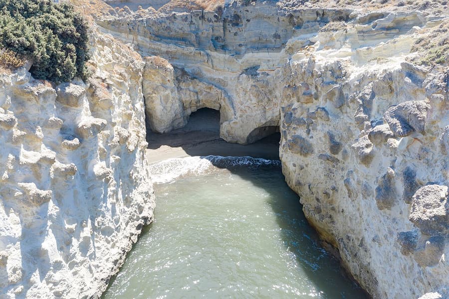
The three caves of Papafragas sit beside the remains of ancient Phylakopi. This places a sea feature next to the ruins of an old city. The beach itself is small, with high, light rocks forming its immediate surroundings.
Grey and white are the rock colours around the water of the cave. The beach has bright, pale rock around it rather than a broad open backdrop. These details keep the focus on the contrast between stone and blue-green water.
Papafragas Cave is deep, but that description does not measure the swimming water. A cave’s shape and a swimmer’s footing are separate matters during any beach visit. Clear depth information matters before anyone chooses a place to enter the sea.
The water between the rocks leads out towards the open sea beyond them. That connection belongs at the centre of any simple description of this place. It also keeps the cave setting distinct from the idea of a closed pool.
A visit to Papafragas does not need to begin with a swimming plan. An interest in caves, pale rock, or the coastal setting gives it another focus. The small beach is part of that setting, rather than its whole story.
The wider choice of beaches on Milos gives context for this small coastal place. Beach plans work better when they reflect personal comfort rather than a fixed checklist. A rocky descent and a sea cave call for separate decisions.
- Setting: Papafragas belongs among the beaches on northern Milos.
- Shore: The small beach sits within tall, light rock.
- Water: Blue-green water passes between grey and white rocks.
- Caves: Three caves stand beside the ancient ruins of Phylakopi.
- Access: The land approach descends through a steep rock carving.
Papafragas is best understood through its beach, its caves, and its connection with open water. Those features give a clear picture without turning the place into a promise about swimming. A visit can remain focused on the setting while leaving the choice of entering undecided.

Where does Papafragas lie in relation to Phylakopi and Pollonia?
Papafragas lies on northern Milos beside the ruins of the ancient city of Phylakopi. Pollonia is farther east along this side of the island. The main road beyond Phylakopi runs downhill towards the north-east and leads on to Pollonia.
Phylakopi stands on the north-east coast, placing the neighbouring caves within that coastal setting. The place names help explain location without adding an exact distance between the stops. Ancient ruins and sea caves are the main points of reference.
The northern coastal order places Kapros before Papafragas when moving from west to east. Phylakopi comes next, followed by Kalogeros, Pelekouda, and then Pollonia along the same coast. This order explains direction without describing a walking route between beaches.
Pollonia occupies the north-eastern part of Milos and sits at the island’s north-eastern tip. It is a seaside village, distinct from the caves and the nearby ancient ruins. A separate look at Pollonia village keeps that destination in focus.
The main road after Phylakopi descends towards the north-east before reaching the village of Pollonia. That gives the coastal setting a useful connection with a named village. It does not define the separate descent from rock to the beach.
For Papafragas, the neighbouring ruins provide a clearer location marker than a guessed journey time. A place beside an ancient city needs no invented distance to explain its position. The northern coastal order gives the remaining sense of direction.
Beach access and island location answer different questions when planning a coastal stop on Milos. The road points towards Pollonia, while the beach approach involves a steep rock carving. Keeping those details separate avoids treating arrival as easy access.
- Island: Papafragas belongs to the northern coast of volcanic Milos.
- Neighbour: Ancient Phylakopi gives the caves a nearby landmark.
- West: Kapros comes earlier in the coastal order from west.
- East: Pollonia follows Phylakopi, Kalogeros, and Pelekouda towards the east.
- Road: Beyond Phylakopi, the main road descends north-east towards Pollonia.
Papafragas has a clear place among the northern beaches, with Phylakopi beside its three caves. Pollonia adds a village reference farther east, rather than an explanation of the beach descent. The useful distinction is between finding the coastal stop and deciding whether to go down.
How did rock and sea shape the Papafragas setting?
Papafragas belongs to volcanic Milos, with pale rocks around the beach and a deep sea cave. Volcanic means formed through the activity of volcanoes. Sea caves develop as waves work into weak rock and enlarge gaps along the coast.
Northern Milos consists of volcanic layers, with older rock lying beneath later layers above it. The lowest and oldest layer is called Pachaina, with the Papafragas layer sitting above. This gives the northern coast a background built from stacked rock.
Milos contains tuff, a rock made from ash thrown out during a volcanic eruption. After the ash lands and settles, it hardens into a solid mass of rock. The ash grains are no larger than grains of sand.
A sea cave begins where the rock contains a weak place that waves can reach. A meeting point between layers with different hardness is one kind of weak place. Wave action then starts to open that weakness further.
Water pushes into cracks and gradually makes those gaps wider and deeper within the rock. Sand and pieces of stone carried by waves also scrape against the cave walls. Together, these actions explain how the sea wears rock away.
The Papafragas setting links a volcanic island with a cave shaped by the sea. That does not make the beach a place for naming every visible rock type. The broader explanation rests on volcanic layers and continuing wave action.
Waves also wear away the bottom of cliffs, leaving rock that projects above the gap. That projecting rock can collapse under its own weight as support below it disappears. Each collapse shifts the shoreline back towards the land behind.
- Origin: Milos is an island formed through volcanic activity.
- Layers: Northern Milos has a series of volcanic rock layers.
- Ash: Tuff forms when fallen volcanic ash becomes solid rock.
- Weakness: Sea caves begin in weak parts of coastal rock.
- Waves: Water, sand, and stone work together to wear rock.
The Papafragas landscape becomes easier to understand when the rock and the sea are considered separately. Volcanic activity explains the island’s background, while waves explain the shaping of sea caves. That simple distinction adds meaning to the pale cliffs without assigning an age to them.
What stories connect the Papafragas name with the sea?
Papafragas takes its name from a Frank priest who sheltered his boat at the beach. The cove also served as a pirate base during Byzantine times. These are separate parts of the place’s story, rather than a single event.
The name story centres on a priest using the beach to protect his boat. The Greek word Papas means priest, which helps explain the personal link behind the name. The focus remains on shelter rather than a named vessel.
The word Frank belongs to the language used by Orthodox Greeks for Western French and Italians. That wider meaning gives context to the priest in the beach’s naming story. It does not supply a personal name for him.
The pirate link at Papafragas belongs to Byzantine times, when the cove served as a base. A base means a place used as a starting point for activity. The story concerns use of the cove rather than a named pirate.
Milos also has a wider past linked to attacks and the struggle against pirates at sea. Arab raiders troubled the Cyclades during the early ninth century, beyond this single beach. That island background remains separate from the cove’s own pirate story.
Italian pirates attacked settlements around the Aegean during the twelfth century, adding another wider sea connection. These regional events do not identify the people who used this particular cove. The distinction keeps island history separate from details about the beach.
During the nineteenth century, Milos became a meeting point for ships fighting pirates in the Mediterranean. This later island role belongs to a different period from the Byzantine cove story. The shared theme is the island’s connection with the sea.
- Name: Papafragas is linked to a Frank priest’s sheltered boat.
- Word: Papas is a Greek word that means a priest.
- Cove: Pirates used the place as a base during Byzantine times.
- Context: Wider pirate activity also affected the islands around Milos.
- Distinction: The priest’s boat and pirate base are separate stories.
The Papafragas name gives the beach a human connection alongside its pale rocks and sea cave. The pirate story adds another use of the cove, placed within the Byzantine period. Keeping these strands apart leaves a clear account without inventing people, voyages, or hidden treasure.
What does the land approach to Papafragas involve?
Papafragas has a land approach that goes down through a steep carving in the rock. The descent is part of reaching the small beach below the surrounding pale rocks. A cautious plan treats going down and returning as linked decisions.
The central access detail is the steep carved rock, not a promise of an easy path. Visitors can assess their comfort before making any choice about going down towards the beach. Remaining above is a valid alternative to descending.
At Papafragas, a plan for reaching the beach also needs a plan for leaving it. Anyone uncertain about the return can leave the descent out of the visit entirely. The beach does not need to become a fixed goal.
For any steep rock approach, careful movement takes priority over photographs or keeping pace with others. Visitors can pause before moving and avoid dividing attention between footing and a screen. A decision to stop needs no further reason.
Footwear that gives a firm grip is a sensible choice for movement over exposed rock. Hands kept free leave attention on balance rather than on carrying loose items downwards. These are general precautions, not a claim about equipment provided nearby.
A group can agree that nobody needs to follow another person down towards the beach. Different levels of comfort deserve space, especially when the approach itself is a concern. The choice to remain above belongs to each individual visitor.
The carved approach at Papafragas is separate from the natural action that makes sea caves. One describes the way down to the beach; the other describes waves wearing rock. Neither description gives a full assessment of footing during a visit.
- Descent: The beach approach follows a steep carving in rock.
- Decision: Visitors can leave the descent out of their plans.
- Return: A clear exit plan belongs before any downward movement.
- Attention: Footing takes priority over photographs during a rocky descent.
- Comfort: Each visitor can decide independently whether to go down.
Papafragas is not a test of confidence, and the small beach does not demand a descent. A plan that leaves room to stop keeps the decision simple and free from pressure. The carved way down matters only when both the descent and return feel manageable.
What matters before swimming in the Papafragas inlet?
Papafragas offers blue-green water between grey and white rocks, with a connection to the open sea. The small beach sits within tall, pale rock around the cove. Swimming decisions need to include entry, an exit, and each person’s comfort in water.
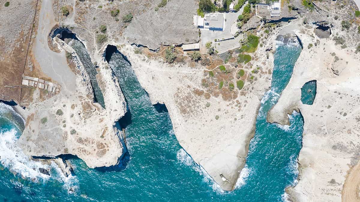
The water at Papafragas leads between rocks towards open sea rather than ending in a closed pool. That simple feature belongs in any decision about entering from the small beach. A swimmer’s plan needs to account for returning as well.
Before entering any rocky cove, swimmers can identify a place where leaving the water feels manageable. An entry point alone is not a complete plan for a swim beside rock. The return deserves attention before the swim begins at all.
Where getting in or out involves rock, slow movement keeps the focus on secure footing. Jumping into water of unknown depth is not a safe way to begin a swim. A gradual entry leaves room to stop and reassess.
At Papafragas, the colour of the water is part of the setting, not a safety assessment. Blue-green water does not replace checking personal confidence, the entry point, and the way back. Appearance alone is not a reason to enter.
Swimming alone leaves no companion nearby to notice difficulty, so shared plans are the safer choice. Companions can agree on a comfortable limit before anyone enters the sea from the beach. No swimmer needs to match another person’s distance.
A beach visit can end without entering the sea, even when swimming was the original plan. Uncertainty about entry or exit is enough reason to leave the water out. The cave, pale rock, and small shore remain the same setting.
- Setting: Papafragas has blue-green water leading towards the open sea.
- Entry: A careful swimmer checks footing before entering beside rock.
- Exit: A return point belongs in the plan before entry.
- Depth: Jumping is unsafe when the water depth is unknown.
- Choice: Leaving swimming out remains a valid beach visit decision.
Papafragas combines a small shore with tall rocks and a sea cave that opens towards the sea. A cautious swim plan keeps entry and exit at its centre from the start. The decision to stay dry leaves the coastal setting no less worth understanding.
What does Phylakopi beside Papafragas reveal about ancient life?
Papafragas sits beside Phylakopi, an ancient settlement on the northern coast of Milos. Its streets, pottery and painted walls offer different ways to think about life there. The ruins add a human story beside the caves and sea.
Phylakopi began as a small village built directly on solid rock. Early pottery was found there, adding objects to the story of its homes. A visit near Papafragas can include an interest in these ancient remains.
The later town had closely packed houses arranged in blocks along straight streets. This layout gives the settlement a clear human scale beyond its ancient name. Visitors can think about homes and streets rather than dates alone.
Pottery carried black and red designs based on plants and animals. Bird jugs from Milos also reached Knossos, on the island of Crete. These objects offer a way to connect the town with places beyond its coast.
The Pillar Room held traces of painted plaster showing a flying fish. This wall painting adds a different detail beside the pottery and house blocks. The fish image brings the sea into the story of the settlement.
A later town stood behind a wall made from large blocks of rock formed by volcanoes. The sea has since washed away part of the ancient site. Visitors can leave the stones untouched while thinking about what no longer remains.
The flying fish wall painting is displayed at the National Museum in Athens. That detail separates the ancient place from the objects found within it. Interest in the ruins need not depend on seeing every find beside its original home.
- Village: The earliest homes stood directly on solid rock.
- Streets: House blocks were split by long, straight streets.
- Pottery: Painted pots carried plant and animal designs.
- Art: A flying fish appeared in the Pillar Room.
- Sea: Waves have washed away part of the settlement.
Papafragas and Phylakopi belong together in a visit focused on place rather than a packed checklist. The caves offer a coastal setting, while the settlement adds traces of human life. Both deserve attention without treating ancient stones as seats or climbing holds.

How can sea trips offer another view of Papafragas?
Papafragas can be considered as part of a north coast outing by kayak or boat. Planning starts with the wind, sea conditions and the abilities of everyone involved. A place on a route never guarantees safe access to its caves.
A boat plan needs room to change when the sea changes during an outing. Visitors can ask about the coast being covered before agreeing to travel. The decision to enter a cave stays separate from the wish to see it.
The kayak route to Papafragas includes Pachaina and Kapros along the coast. That route offers a starting point for questions, not a promise about conditions. Paddlers need a clear return plan before leaving land for open water.
For a kayak outing, the group can discuss experience before deciding where to paddle. Anyone unsure about handling the craft can choose to remain on land. The aim is a shared plan that leaves nobody under pressure to continue.
Viewing the coast from water does not need to include entering a sea cave. A cautious plan keeps space between the craft and surrounding rock. Visitors can accept a view from outside without treating closer access as the main goal.
For a boat outing, visitors can agree beforehand whether the plan involves viewing the coast or entering water. Those choices remain separate, with no pressure to swim simply because the group has reached a planned stop. Staying aboard remains an acceptable decision when personal confidence does not match the proposed activity.
At Papafragas, the water between grey and white rock leads towards the open sea. This connection belongs in any discussion about a stop beside the caves. A plan focused only on the enclosed view leaves that wider setting out.
- Conditions: The sea takes priority over a planned route.
- Experience: Each paddler needs a plan suited to personal ability.
- Space: Viewing from outside avoids making cave entry the goal.
- Return: The group agrees how to end the outing safely.
- Choice: Staying on land remains an acceptable change of plan.
A sea view of Papafragas is best treated as an option rather than an obligation. The plan can end outside the caves, or remain a land visit instead. A successful outing respects the limits of the weather and every person taking part.
When does the north wind affect plans for Papafragas?
Papafragas faces the northern side of Milos, where north winds matter when planning a visit. The meltemi is a strong, dry wind blowing across the Aegean from the north. Clear skies do not mean that the sea is calm.
The meltemi brings a north wind across the central Aegean during summer. Its direction is worth checking alongside its strength before a coastal visit. A weather plan needs both details, rather than a glance at the sky alone.
Papafragas belongs to the north coast, beside the ancient settlement of Phylakopi. Its position makes wind direction part of planning before arrival at the shore. Visitors can keep the coast in mind without committing to a swim.
The wind reaches its strongest level in the afternoon and eases at night. Yet a spell can continue for days without a break in its flow. An early visit therefore carries no promise of calm water or easy conditions.
A clear sky can arrive alongside a sea covered in waves during meltemi weather. The wind can also begin without warning while the sky remains clear. Blue skies alone are not a sound reason for choosing to swim.
During north winds, beaches in the bay or on the south coast suit swimmers better. Changing the destination is a practical response, not a failed day out. The choice can follow conditions instead of a fixed plan.
- Direction: A north wind deserves attention on this northern coast.
- Sky: Clear weather does not establish that swimming is safe.
- Timing: Afternoon brings the strongest phase of the meltemi.
- Persistence: A windy spell can carry on for days.
- Alternatives: The bay and south coast offer better choices during north winds.
Papafragas does not need a promised swimming stop to belong in a coastal plan. A visit can remain focused on the setting when the wind rules out water activities. Leaving space for a different beach keeps the day from depending on a risky decision.
What safety choices matter on the rock and in Papafragas?
Papafragas calls for a cautious approach on land and in the water below. Visitors need shoes with grip, a check of the sea and a shared swimming plan. Nobody swims alone, and nobody needs to continue when the situation feels unsafe.
Shoes with grip belong in a plan for walking beside rock and uneven ground. Visitors can choose footwear before arriving rather than making the decision at an exposed spot. Hands stay free for balance, with loose belongings put away before moving.
A careful pace leaves room to look at the next step before taking it. Visitors can stop on secure ground instead of moving while studying the sea. An uncertain foothold is a reason to turn back, not a test to overcome.
The sea needs checking before anyone decides to enter the inlet for a swim. The plan includes a clear way out and a decision about when to leave. If either feels doubtful, staying out of the water is the safer choice.
Swimming at Papafragas belongs in a shared plan, never a solo attempt made without support. Companions can agree to stay aware of each other throughout the swim. A person waiting elsewhere does not replace a clear agreement about staying together.
Nobody needs to follow another person into water or towards a rock edge. Each visitor can stop when the next step feels beyond personal comfort. A group plan works best when turning back is accepted without argument or pressure.
Jumping from rock has no place in a cautious plan for an unfamiliar inlet. Keeping back from edges also leaves room for a calm decision about the next move. The visit can end without anyone entering the water at all.
- Footwear: Shoes with grip belong in the walking plan.
- Footing: Visitors pause on secure ground before looking around.
- Water: A sea check comes before any decision to swim.
- Company: Swimming alone has no place in the visit.
- Limits: Turning back remains acceptable at every stage of the stop.
A safe visit to Papafragas begins with permission to stop, turn back or remain above the water. Shoes, company and a sea check belong together rather than acting as separate promises of safety. The final choice rests on the conditions and each visitor’s limits.
Which places belong near Papafragas on a north coast plan?
Papafragas shares the north coast with Pollonia, Sarakiniko, Pachaina and Mytakas. These places offer different coastal settings, from a fishing village to sandy beaches and pale rock. A flexible plan chooses between them without turning every name into a required stop.
Pollonia lies at the north eastern end of Milos, beyond Papafragas along the northern coast. Sand and tamarisk trees line the cove that the fishing village wraps around. It offers a village setting to place beside the caves in a coastal plan.
Sarakiniko has pale rock shaped by waves driven against it by north winds. Its beach occupies a small part of the wider setting between white rocks. The Sarakiniko beach overview offers a separate place to consider alongside this inlet.
Pachaina has a sandy shore facing Glaronisia, with tamarisk trees and blue water. Rocks rise through the water, adding another detail to the beach setting. Visitors can include its name in a north coast plan without fixing a swimming stop.
Mytakas combines a sandy northern beach with a settlement of fishermen’s houses. Its clear water lies between narrow capes, the pieces of land beside the beach. This is another named place to consider without adding a timetable to the day.
The coastal order from west to east places Sarakiniko before Mytakas and Pachaina. Pollonia lies farther east along the same northern side of the island. This order helps arrange the names without making claims about travel times or road distances.
- Pollonia: A fishing village sits around a sandy cove.
- Sarakiniko: Pale rock surrounds a beach of fine white sand.
- Pachaina: Sand and tamarisk trees face the Glaronisia islets.
- Mytakas: Fishermen’s houses stand beside a northern sandy beach.
- Phylakopi: The ancient settlement lies beside the caves.
Papafragas can remain the focus while nearby places add choices rather than obligations to the day. A broader look at activities in Milos helps frame that choice without fixing every stop. The final plan can stay centred on the coast and the conditions.

Which practical questions help with a visit to Papafragas?
Papafragas raises practical questions beyond the caves, wind and nearby places. Families, photographers and visitors planning a longer day can leave room for changing conditions. Simple choices about sun protection, space and food matter without turning the visit into a fixed schedule.
How can families plan a visit to Papafragas with children?
Families visiting Papafragas can choose to stay on secure ground rather than making the beach their main goal. An adult can keep children close and stop the visit before anyone feels pushed beyond personal comfort. Turning back early is always a good choice with children.
How can visitors plan for shade and sun at Papafragas?
A sun plan works best without depending on finding a shaded place beside the inlet during the visit. Visitors can bring a hat, sun protection and drinking water while leaving time to rest away from exposure. If comfort drops, ending the stop is a sensible choice rather than waiting for the planned departure.
What approach suits photos at Papafragas without taking risks?
Photos of Papafragas can focus on pale rock and the water without placing anyone close to an edge. A visitor can stop on firm ground before lifting a camera, keeping attention on footing between each shot. A missed picture is a better outcome than moving backwards without checking the ground behind the next step.
How can visitors handle crowds during a Papafragas stop?
Milos attracts summer tourists, but that does not establish how crowded this stop will feel on arrival. Visitors can leave space for others and wait on secure ground rather than squeezing past beside the rock. If the area feels too crowded for comfortable movement, the visit can end without reaching the water below.
How can parking fit into a Papafragas visit plan?
Parking plans for Papafragas need a safe stopping place that leaves space for passing traffic and people walking. Drivers can check signs and restrictions before leaving the car, rather than assuming every open space permits parking. If a suitable place is unavailable, changing the stop is better than leaving a vehicle in the way.
How can spring and autumn visits to Papafragas stay flexible?
A spring or autumn plan can centre on seeing the coast without making a swim the main aim. Visitors can check the forecast close to departure and judge the sea again after arriving beside the inlet. The season alone does not settle the decision, so a change of plan remains part of the visit.
How can food and drink fit around a Papafragas visit?
Pollonia has places serving meals and drinks, making it an option when food belongs in the coastal plan. Visitors can carry drinking water for the stop itself rather than making refreshment depend on an unplanned search. Any meal stop can stay separate from the beach visit, with litter kept together and taken away afterwards.
Can Papafragas and Sarakiniko share a plan for the same day?
A shared day plan can include Papafragas and Sarakiniko without setting a fixed length for either coastal stop. Both belong to the north coast, so the wind remains part of the decision at each separate place. Visitors can shorten either visit or leave swimming out, keeping plans centred on conditions rather than completing stops.