Route No. 2 covers a distance of 6.5 km and lasts about 2.5-3 hours. We start at Agios Konstantinos beach and set off in our kayaks to begin our exploration. First we come to Alogomantra beach and then the traditional village of Agios Konstantinos. Next we pass magnificent caves and fantastic, breathtaking geological formations. After that, we come across the two Pachena beaches, Kapros beach and the Papafragas caves. We stop for a 20-30 minute break at the small cave of Papafragas, where anyone who wishes can explore Filakopi’s surroundings on foot with a guide, or swim to explore the nearby caves. After lunch we set off on the way back, paddling more intensely this time. We pass the cave and the Kanal of Kofto, take a look at the two caves of Agios Konstantinos, and then return to the beach. Price: 35 euros
The northern coast of Milos hides a shoreline that opens best from the water, and Milos kayak routes cover the bays that no road reaches. A sea kayak slips past white cliffs, low coves and dark caves. One paddle leads from a quiet fishing harbour to the sea caves below a Bronze Age town. The sea shows the coast at its own pace.
The kayak Papafragas route follows that line. It begins at Agios Konstantinos beach, turns east along the coast, passes the beaches of Alogomantra, Pachena and Kapros, and finishes at the caves of Papafragas. The return brings the channel of Kofto and the two small caves of Agios Konstantinos. The line hugs the shore the whole way.
What does the kayak Papafragas route look like?
The kayak Papafragas route runs 6.5 kilometres from Agios Konstantinos beach east along the northern coast to the caves of Papafragas, then back past the channel of Kofto. Alogomantra, the village of Agios Konstantinos, the two Pachena beaches and Kapros stand in that order.
The route begins in the small cove of Agios Konstantinos, where the water stays flat and turquoise behind the harbour wall. A paddler leaves that shelter and heads east, keeping the pale cliffs on the right. The first bay is Alogomantra, a strip of sand pressed against tall rock. The village of Agios Konstantinos comes next, its low houses carved into the soft stone above the landing. The sea stays shallow for a long way out, and the kayak Papafragas route crosses water so clear that the bottom shows through.
The rock along this coast is volcanic. Layers of tuff and trachyte build the walls that close each bay, and the sea has cut them into arches, tunnels and round hollows. The oldest layer carries the name of Pachena and lies at least 70 metres thick. Above it sits the Papafragas layer, which grows thicker towards the east. A paddler reads that order in the cliff face. The island began to build itself two to three million years ago, and the volcanic action stopped 90,000 years ago.
The route stays close to the land, so the swell stays small on calm mornings. Between the bays the coast turns rocky, and the kayak Papafragas route passes below walls of pale stone that drop straight into deep water. There is no road above for long stretches, and the only company is the sound of the paddle and the call of gulls. The paddling is steady rather than hard. The island counts 90 beaches in all, and 17 of them face north.
At the far end the cliffs close in around a narrow entrance. The water turns green and still. The route finishes inside that shadow before the return begins. The whole line of the coast then repeats in reverse, with the sun behind the paddler and the cliffs lit from the other side. Pumice, a stone of almost pure glass, shows in the cliffs from Kofto eastwards to Mitakas. The colour stays pale the whole way back to the harbour.
- Distance: The kayak Papafragas route covers 6.5 kilometres of northern coastline.
- Start point: The beach of Agios Konstantinos on the northern coast.
- Direction: East along the shore to the caves, then back the same way.
- Landmarks: Alogomantra, Pachena, Kapros and the caves of Papafragas.
- Return: Past the channel of Kofto and the two caves of Agios Konstantinos.
The kayak Papafragas route suits a paddler who wants a coastline rather than a crossing. The land stays near, the water stays clear, and every bay offers a place to pause. The kayak routes of Milos reach other coasts too. The distance of 6.5 kilometres is modest, but the cliffs and caves give the trip weight. The route ends where it began, in the same quiet harbour.

Where does the kayak Papafragas route start on Agios Konstantinos beach?
The kayak Papafragas route starts at Agios Konstantinos beach, a small fishing harbour on the northern coast of Milos. The settlement sits inside a little fjord with turquoise water, and its buildings are carved into the soft rock around the bay. Alogomantra lies just to the west.
Agios Konstantinos is one of the traditional fishing settlements of Milos, built inside a small cove on the northern coast. Its houses sit low against the rock, and the water in front stays calm even when the open sea is restless. The beach itself is a band of sand with a scatter of white pebbles. The kayak Papafragas route begins beside it, and the name of the place comes from the small church of the saint, cut into the soft stone at the southern edge of the bay.
A short paddle west brings Alogomantra into view. It is a strip of sandy beach squeezed between tall rocks, and the road above never shows it. The ground near it is rocky and sloping, and the water is shallow and green-blue over the stones. The shape of the bay looks like a fold or an enclosure, and that form gave the place its name. The kayak Papafragas route sees this beach only from the sea.
The village keeps its boats in carved shelters called syrmata, cut straight into the volcanic tuff. Fishermen once pulled their craft from the inner end to the water and closed them in for the winter. Later the same rooms became summer quarters, painted in bright colours. Above the beach a cross stands out from the rock, with the chapel carved below it. Two small caves open in the same little harbour, ready to explore before the paddle turns east.
The bay gives shelter, and that shelter decides the start. A paddler launches from the sand into water that feels closed, like a lake, before the open coast begins. The cliffs around the entrance frame the first view of the route, and the light on the pale rock changes through the morning. The first stretch is gentle, with the stone close on one side and flat water under the hull, and the kayak Papafragas route carries on past the headland.
- Beach: Sand and small stones in a sheltered cove.
- Village: Low houses and carved boat shelters above the landing.
- Church: A small chapel cut into the rock below a stone cross.
- Caves: Two small caves at the mouth of the harbour.
- Alogomantra: A hidden strip of sand just west of the start.
From the water the settlement looks smaller than the cliffs behind it. The kayak Papafragas route leaves the harbour with the rock on one side and open water on the other. Alogomantra disappears behind the first headland, and the coast takes over. What follows is 6.5 kilometres of bays, caves and volcanic walls, with the landing point waiting at the end of the line.
What caves and rock formations does the kayak Papafragas route pass?
The kayak Papafragas route passes sea caves cut by the waves and the channel beside the islet of Kofto, which faults opened. The two small caves of Agios Konstantinos wait near the start, and the paddler meets them again on the way back.
The coast gives the paddle its shape. Volcanic rock cools and cracks, and the sea works on the weak lines for a long time. Where a fault or a vein crosses the stone, water widens the opening until a cave forms. Where the cave cuts right through a headland, an arch stands for a while and then falls, leaving single pillars in the water. The kayak Papafragas route moves past that work in progress. The result is a coast full of openings.
Near the start the two small caves of Agios Konstantinos open just outside the harbour. The route meets them again on the way back, when the light is different and the entrances show as dark mouths in pale rock. The islet of Kofto lies about 200 metres east of the beach, and the kayak Papafragas route passes close to it. It was once a small headland joined to the land, and the ground between them has since cracked and sunk, so a narrow channel separates the two.
The channel beside Kofto is the deepest cut on the whole line. Faults opened it, and the sea keeps it clear. A small colony of gulls nests on the islet, and their calls carry across the water. From Kofto eastwards the rock changes to pumice, a volcanic stone made almost entirely of glass. The cliffs keep their pale colour, but the surface turns soft and light, and the kayak Papafragas route runs under them. The change in the stone is easy to see.
Further out, the uninhabited islets to the north show another formation. Andesite there stands in upright columns, packed side by side. Such columns form when lava cools and shrinks, and the cracks divide the mass into polygons with three to eight sides. Six sides appear again and again. Diameters run from a handful of centimetres to three metres, and the tallest reach about thirty metres. The kayak Papafragas route watches them from a distance. The shape is a signature of cooling lava.
- Sea caves: Openings cut by the waves along the pale cliffs.
- Kofto: A small island split from the coast by a channel.
- Gulls: A nesting colony lives on the islet of Kofto.
- Pumice: A light volcanic rock, almost pure glass, east of Kofto.
- Columns: Upright andesite pillars on the islets to the north.
Rock, water and time do the work together. The kayak Papafragas route passes the result without touching it. The caves stay dark at the edges and green at the mouth, where daylight reaches the water. The channel at Kofto carries the kayak back towards the start, and the two small caves of Agios Konstantinos close the loop. The cliffs keep changing colour until the little harbour opens again.
Which beaches does the kayak Papafragas route pass at Pachena and Kapros?
The kayak Papafragas route passes two Pachena beaches with rich sand and tamarisk trees, then Kapros, a small cove of fine sand between white rocks. Both lie on the northern coast, and the water in front of them is blue and clear.
Pachena is a roomy beach on the northern side of the island. The sand is deep, and a line of tamarisk trees gives shade at the back. Rocks rise out of the blue water a short way offshore, and the view north opens onto small uninhabited islets. The landing is easy, and the beach invites a second pause. The kayak Papafragas route passes the twin bays of Pachena on the way east. The water stays shallow well out from the sand.
The name Pachena belongs to a settlement as well as a beach. The place counts among the inhabited settlements of the island, together with Mitakas and Pollonia further east. From the sand the eye reaches the islets opposite, which sit administratively with Triovasalo and were recorded as uninhabited at the census of 2011. The islets stay on the horizon for the whole crossing of the bay. The kayak Papafragas route keeps them in sight, and their low outline marks the northern edge of the crossing.
Kapros comes next. It is a small cove set between white rocks, with fine sand underfoot and blue water in front. The bay opens to the main road above, so the beach is easy to reach by car or by bus, unlike Alogomantra further west. The white rock around it belongs to the same volcanic palette that gives Milos its colour, and the kayak Papafragas route meets that white here. The road to Pollonia passes above it.
The two beaches show different faces of one coast. Pachena is wide and soft, with trees, deep sand and a long view to the islets. Kapros is small and tight, held inside white stone, with room for a single landing. Pachena hides behind its own bay, while Kapros shows its shape from the road. Both stand outside the great horseshoe bay that the island curls around. The kayak Papafragas route touches each one and leaves the sand untouched behind the hull.
- Pachena: A wide beach with deep sand and tamarisk trees.
- Two bays: The northern coast holds two Pachena beaches in a row.
- Islets: Small uninhabited islands sit opposite, to the north.
- Kapros: A small cove of fine sand between white rocks.
- Access: Kapros is visible from the main road and easy to reach.
After Kapros the coast narrows and the cliffs return. The kayak Papafragas route leaves the soft sand behind and enters rock again. The next turn takes the paddler towards the caves, where the water deepens and the colour changes. Pachena and Kapros stay behind as two quiet pauses in a long line of harder stone. Ahead the entrance to the caves opens low in the cliff, and the beach below it is the last landing before the turn home.
What happens on the kayak Papafragas route at the caves of Papafragas?
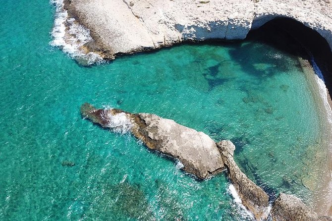
The kayak Papafragas route ends at a deep sea cave with blue-green water. Grey-white walls close a narrow passage that joins the cave to the open sea. A small beach lies beside it, shut in by tall pale rocks, and the paddler rests there.
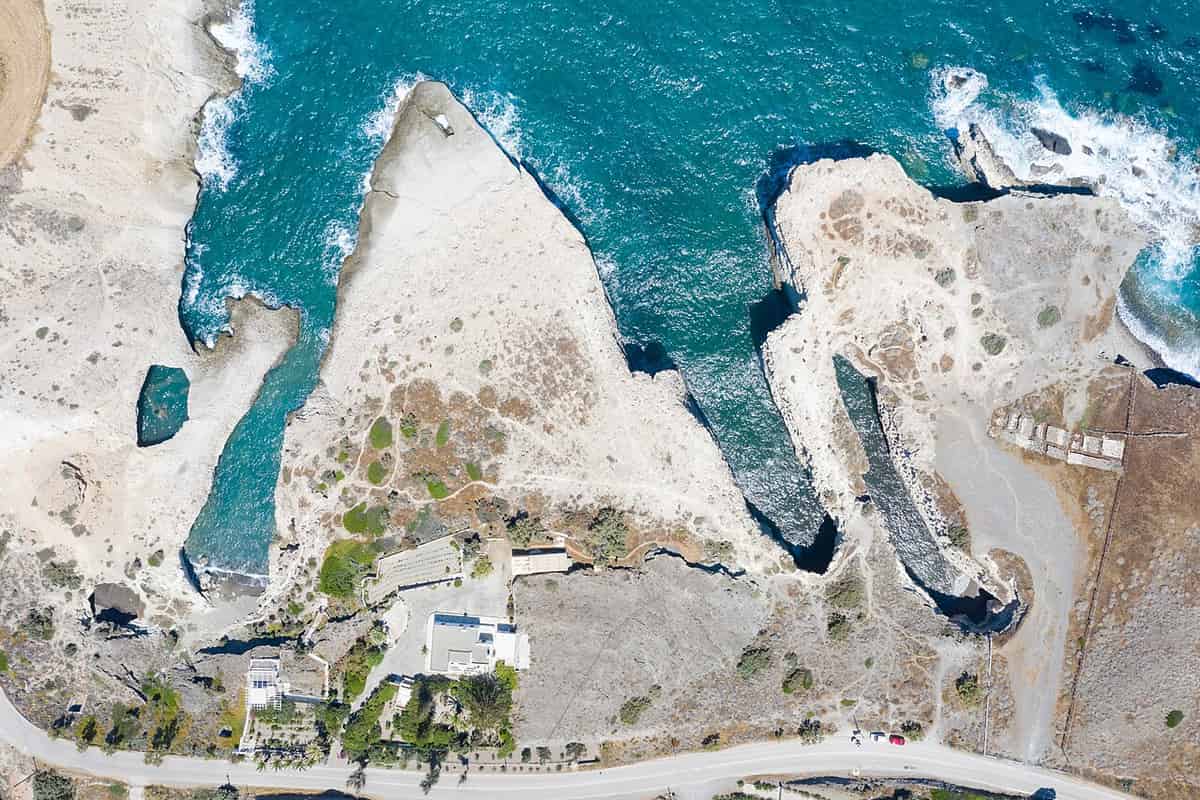
The cave is a marine one, which means the sea runs inside it. It sits within the bounds of the archaeological area of Phylakopi, and the settlement above it stands no higher than ten metres. Grey-white walls close a narrow passage filled with blue-green water. That passage joins the inner part of the cave to the open sea. The kayak Papafragas route enters straight from the water, so no climb down the rock is needed.
Beside the cave a small beach opens, framed by huge pale rocks. The water in front keeps a green tone, and the sand gives a natural place to land. The kayak Papafragas route stops here, and the paddler can step out onto the shore. The shape of the bay recalls the white volcanic stone of the island, where bare rock meets the sea without a break of green. The beach is small, so the pause stays short.
The stop carries an option. Anyone who wishes can swim from the beach into the caves nearby, where the water stays calm and the light falls in bands across the walls. The same stretch also holds three sea caves beside the ruins of the Bronze Age town. Swimming inside them shows the stone from below, close to the surface. The kayak Papafragas route turns back from the same small beach. The water runs among grey and white rocks and reaches the open sea.
The name itself carries a story from the Byzantine years, when the cave served as a base for pirates. A Frankish priest used the beach to shelter his boat, and the two words for priest and Frankish joined to give the place its name. The northern coast holds a second pirate memory, since Saracen raiders gave their name to the white beach further west. The kayak Papafragas route passes both. The outward paddle ends here, and the kayak Papafragas route reverses its course.
- The cave: A deep sea cave with blue-green water inside.
- The passage: A narrow opening joining the cave to open water.
- The beach: A small shore held between tall pale rocks.
- Swimming: A swim from the beach reaches the caves nearby.
- The name: A priest and a Frankish word gave the place its title.
The break at Papafragas brings the outward leg to an end. The kayak Papafragas route turns there, and the cliffs that closed the view now open behind the paddler. The light is different on the way back, with the sun on the other side of the coast. The channel at Kofto and the two small caves of Agios Konstantinos wait on the return, before the harbour ends the trip.
What lies above the kayak Papafragas route at Phylakopi?
The kayak Papafragas route runs below Phylakopi, a leading Bronze Age settlement of the Aegean islands. Life there lasted about two thousand years, from 3300 to 1100 BC, and the ruins sit on the slope directly above the caves. A short walk from the water reaches them.
Phylakopi stands on the northern coast, and the kayak Papafragas route travels below its ruins. The town counts among the important settlements of the Bronze Age in the Aegean and the Cyclades. Its life ran without a break from the middle of the third millennium to the twelfth century BC. That continuity made the place a reference point for the study of the period. The first people there were tuna fishermen, who arrived as the mining of obsidian was already declining.
The settlement passed through three main phases. The first is dated from 2300 to 2000 BC, the second from 2000 to 1550 BC, and the third from 1550 to 1100 BC. In the middle phase the town grew dense, with blocks of houses separated by long straight streets. Potters there made jugs shaped with birds, and those vessels travelled as far as Knossos in Crete. Trade with Crete and the mainland shaped the later years. The history of Milos begins with the same volcanic stone.
In the final phase the town gained a strong wall, streets laid out towards the points of the compass, and drains. A great hall stood at its centre, with a main room of about 8.6 by 6.2 metres and a hearth in the middle. Painted fragments found nearby show flying fish, and the pieces are held today in the national museum of Athens. The wall at the neck of the old headland is built from volcanic stone in polygonal style.
The sea has taken a large part of the town. Coastal erosion carried away much of the headland and the ancient remains with it, and part of the site now lies below the water that the kayak Papafragas route crosses. The block of rooms built on the high point of the central ridge survived. A short walk on land during the break reaches the protected archaeological area, which is open to visitors and holds information panels and plans.
- Phylakopi: A Bronze Age town on the slope above the caves.
- Dates: Occupation ran from 3300 to 1100 BC without a break.
- Phases: Three main building periods divide the long history.
- Monuments: A great hall, a sanctuary and a wall of volcanic stone.
- Erosion: The sea has carried away a large part of the town.
The town and the cave belong to the same protected area, so the break on the water sits directly below the ruins. The kayak Papafragas route gives a view of the coast where the sea has eaten into the old headland. A walk up the slope shows the wall, the hall and the sanctuary at close range. A walk along the same coast follows the cliffs above. Then the paddle turns back along the shore towards the harbour.
What else does a paddler ask about the kayak Papafragas route?
The kayak Papafragas route invites questions about swimming, wind, rock and history. The answers below cover the details a paddler wants before setting out from Agios Konstantinos beach. A little preparation helps. Each answer follows the shape of the coast.
Is the kayak Papafragas route suitable for a beginner?
The water stays close to the land for the whole line, and the bays give shelter from the swell. A paddler can cover the distance of 6.5 kilometres. The route turns back on itself, so the return follows the same coast. Flat water in the morning helps, and the harbour offers a simple place to start and finish.
Which way does the wind blow on the kayak Papafragas route?
The northern coast takes the full force of the northern summer wind, which arrives from the north and north-west. It builds through the afternoon and drops at night. Mornings give the calmest water, and the months at either end of the summer season bring quieter days. A paddler watches the sea before leaving the harbour of Agios Konstantinos.
Can a paddler swim on the kayak Papafragas route?
Swimming is part of the stop at the caves. The water inside the sea cave stays calm, and the nearby caves can be entered from the small beach. At Pachena and Kapros the shore invites a second swim, with shallow water over sand. The two small caves near Agios Konstantinos offer a last chance before the paddle ends.
Does the kayak Papafragas route pass an archaeological site?
It does. The caves of Papafragas sit inside the protected area of Phylakopi, and the ruins lie on the slope above. The town was a leading settlement of the Bronze Age in the Aegean, and its life ran from 3300 to 1100 BC. A short walk from the landing reaches the site.
What does a paddler carry on the kayak Papafragas route?
A kayak moves by human power alone, without engine or sail, so the kit stays simple. Water belongs in the boat, since the sun reflects off the sea and raises the risk of heat. A spray deck keeps water out of the cockpit on rough days, and a life jacket belongs on the body. Shoes help on the rocky landings.
Which islands are visible from the kayak Papafragas route?
Kimolos shows to the north-east across the narrow strait that separates it from Milos. From the low hills south of Pollonia both Kimolos and Polyaigos come into view, and Polyaigos lies uninhabited to the east. The small islets opposite Pachena stay on the horizon for the whole crossing, and their columns of andesite stand in rows.
When is the best light on the kayak Papafragas route?
The hours just after sunrise and just before sunset give a warmer and softer light, with long shadows across the cliffs. The middle of the day throws hard reflections on the water and dark shadows on the rock. A morning start also meets the calmer sea, so the two advantages arrive together with the kayak Papafragas route.
Why is the rock white on the kayak Papafragas route?
The island is volcanic, and its stone appears in white, red, yellow and black. The northern layers were laid down by volcanic action and later shaped by the waves. Ash and lava compacted into tuff and trachyte, and the sea smoothed the faces into pale walls. The beaches of the island hold white sand from the same material.