Route No. 2 covers a distance of 8.1 km and lasts about 3 hours. We set off by kayak from Lagada beach and pass the French monument, Fanari, the settlements of Skinopi and Small Skinopi, before arriving at Klima beach. We leave our kayaks and start hiking towards the Catacombs. On the way we first come to Saint Paraskevi’s church, and then we take a guided tour of the tombs and chambers. Next we reach the spot where the statue of Aphrodite of Milos was found, the Baptism place and, of course, the Ancient Theatre. Then we go downhill to Klima, where we have a short break for lunch and photos at “Yellow Sirma”, a small shop full of beautiful handmade jewellery and other artistic creations. Finally, we paddle back to Adamas by kayak.
Price: 35 euros
The deep gulf of Milos gives the island a long inner shore of coves, rock and small settlements. The kayak to Klima Milos route follows that shore from Lagada beach to Adamas and places a walk through the ancient city in the middle of the paddle. The island of Milos keeps the whole line of the route inside its bay, away from the open sea.
Klima sits at the entrance of that bay, below the village of Tripiti, and the ancient city of Melos spread over the slope above it. The kayak to Klima Milos outing joins water and land: a paddle along the shore, a climb on foot to the early Christian cemetery, and a return on the water to the harbour town. The full distance is 8.1 km.
What does the kayak to Klima Milos route cover from Lagada beach to Adamas?
The kayak to Klima Milos route covers 8.1 km of the gulf of Milos, from Lagada beach to Adamas. The paddle passes the French monument, the point of Fanari, Skinopi and Small Skinopi, then lands at Klima for the walk up to the ancient city.
Lagada lies among the beaches inside the gulf of Milos, on the shore near the port of Adamas. The kayak to Klima Milos route sets off from its sand, with the water flat against the land and the first strokes running along the coast. The far side of the bay closes the view. A paddler finds a steady rhythm on this first leg, because the shore gives a clear line to follow and the land stays near.
The order of the paddle is fixed. A kayak leaves Lagada and passes the French monument on the low ground above the water, then the point of Fanari, where the land turns and the bay opens. Next come the settlements of Skinopi and Small Skinopi, both on the same shore, with small houses set close to the sea. The line then crosses to Klima at the entrance of the gulf. The kayak to Klima Milos route keeps every one of these places on the water side.
At Klima the paddling half ends and the walking half begins. The kayaks come out of the water and stay on the sand, and the group climbs the slope above the village on foot. The path leads to the early Christian cemetery and the ruins of the ancient city, then down again to the shore. The change from boat to boots takes two steps, and the kayaks wait at the water’s edge. The beach stays within sight during the climb, so the boats never leave the view.
The return is paddled to Adamas, the harbour town of the island, which stands on the north-eastern coast of the gulf. Adamas had 1,268 residents in 2021 and grew from a settlement of Cretan refugees in 1831. The water on this leg is the same sheltered water of the inner bay. The last leg closes the line at the port where the day began. The kayak to Klima Milos route finishes at the harbour town that serves the whole island.
- Start: the paddle begins on the sand at Lagada beach.
- Distance: the kayak to Klima Milos route covers 8.1 km in all.
- Landfall: the kayaks come ashore at Klima for the walk.
- Walk: the path climbs from the shore to the ancient city.
- Finish: the return paddle ends at Adamas, the port of the island.
The shape of this outing is simple to hold in mind. A paddle along the inner shore, a landing at the fishing village, a climb on foot to the ruins above, and a last stretch of water back to the harbour. The route forms one of the paired combined activities in Milos, because it hands over from kayak to walk at Klima.

Which coast does the kayak to Klima Milos route show from the water?
The kayak to Klima Milos route shows the inner coast of the gulf, where the water meets low rock, a monument, a headland and two settlements. The land stays close on one side of the paddle for the whole line.
The gulf of Milos is a deep bay that cuts the island into two parts and leaves a long shore inside it. The kayak to Klima Milos route travels that inner edge, so the coast is never far from the boat. Volcanic tuff, trachyte and obsidian lie among the ordinary rocks of Milos, and the shore shows those materials in pale cliffs above the water. Mount Profitis Elias, at 751 metres, stands far to the west and stays out of this view.
The first fixed point on the coast is the French monument. Adamas served as the base of the French fleet during the Crimean War, and a military cemetery of French and English dead lies near the town. A warship of the French navy still comes to the island once a year to honour the buried sailors. The kayak to Klima Milos route passes the monument before the land turns, and the stone stands above the water on the shore of the gulf.
Fanari comes next, at the point where the coast bends away and the bay widens. The rock there is low and broken, and it carries a face toward the open water, where the swell of the Aegean meets the land. Wind reaches this point before it reaches the inner coves, so the surface of the sea changes colour and texture within a short distance. The kayak to Klima Milos route rounds Fanari and leaves the exposed edge behind.
Skinopi then holds the shore at the sea entrance to the gulf, three kilometres west of Adamas and three kilometres south of Plaka, and its name belongs on the list of gulf beaches. The settlement counted no residents in 2021, after two residents in 2011, and its houses stay close to the water. Small Skinopi stands beside it on the same line of coast. From a kayak the two places read as one low group of walls set between rock and water.
- Rock: volcanic tuff and trachyte form the pale shore of the gulf.
- Monument: the French monument stands on the coast of the kayak to Klima Milos route.
- Headland: the point of Fanari marks the turn of the land.
- Settlement: Skinopi sits at the sea entrance to the bay.
- View: the far shore of the gulf stays in sight through the paddle.
Seen from the water, this coast is a line of small changes rather than one wall of rock. A monument, a headland, two settlements and a village follow one another at short intervals, and each one alters the shape of the bay. The kayak to Klima Milos route holds the land on one side for its whole length. The next section moves from the wider shore to the single place where the paddle finishes, the fishing village of Klima.
What do the boathouses at Klima show on the kayak to Klima Milos route?
The kayak to Klima Milos route finishes its paddle at Klima, where a row of fishermen’s boathouses stands at the water. The houses are cut into rock, their painted doors face the sea, and the ground floor of each one held a boat.
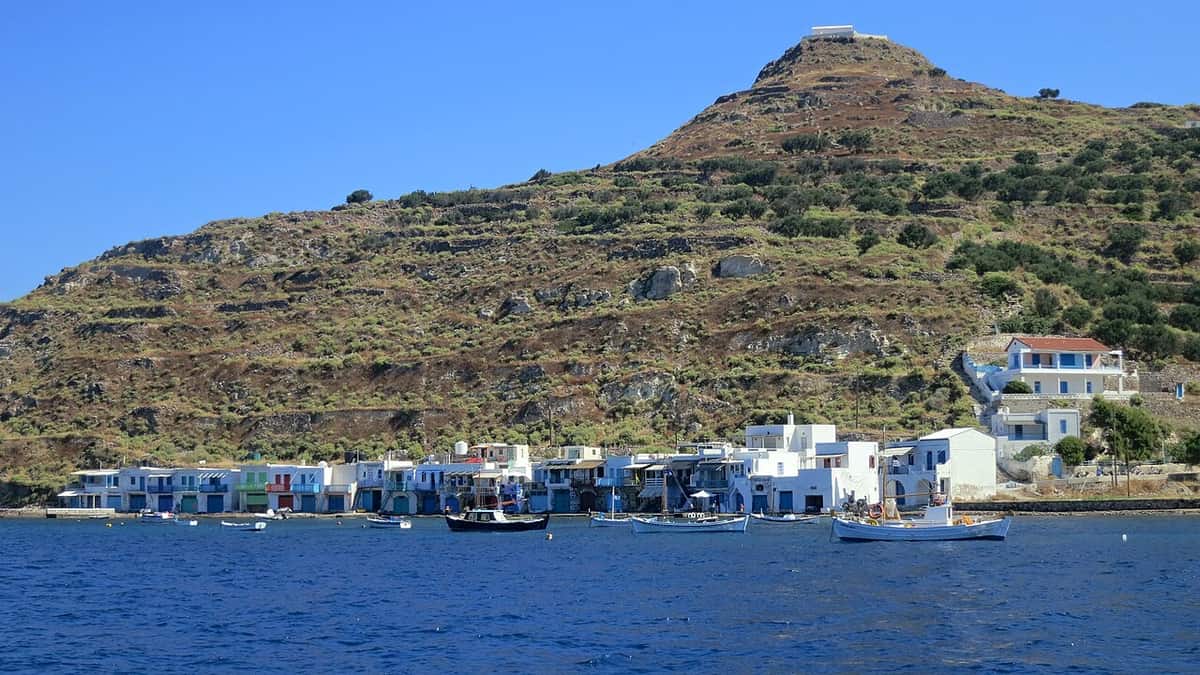
Klima is the fishing village of Milos at the entrance of the gulf, below the village of Tripiti and six kilometres from Adamas, the main port of the island. The settlement had eight residents in 2021 and has been a designated traditional settlement since 1978. The kayak to Klima Milos route arrives at its beach, and the first thing a paddler sees from the water is a single unbroken line of buildings at the edge of the sea.
The houses are known as syrmata, and each one holds a boat. A sirma is a two-storey building dug into the volcanic rock: the family lived on the upper floor and the ground floor kept the fishing boat through the winter. Doors and windows carry strong colours, and the openings face the water so that a boat can be drawn inside. Syrmata of the same kind stand at Mandrakia and at Firopotamos on the island.
From a kayak the row reads as a single wall of doors at the sea line, and that line follows an older harbour. The cove served the ancient city as a landing place, and silt from the valley now covers much of that port, while part of it lies under the sea. The kayak to Klima Milos route therefore crosses water that once lay inside a working harbour, with the boathouses on the edge of what remains.
The village beach and the nearby beach of Schinopi suit swimming, and eating places work in the village. The cave church of Agia Paraskevi stands inside the settlement, and a number of the boathouses now serve as accommodation. Residents live and work here, so a visitor keeps quiet, stays on the shore, and leaves boats, gear and doors untouched. The kayak to Klima Milos route brings a group into a working village, not an empty set of ruins.
- Residents: eight people lived at Klima in 2021.
- Boathouses: a sirma kept a boat below and the family above.
- Rock: the houses are cut into soft volcanic tuff.
- Harbour: the kayak to Klima Milos route crosses a silted ancient port.
- Beach: the village beach and Schinopi beach both suit swimming.
Klima works on two levels at once. The boathouses stand at the water on a line set by an older harbour, and the ruins of a Dorian city lie on the slope behind them. The kayak to Klima Milos route joins the two, because the boats stop at the shore and the walk begins on the same beach. Two periods share one cove, and the next section follows the climb from the water to the graves above.
What does the walk from Klima to the catacombs add to the kayak to Klima Milos route?
The kayak to Klima Milos route adds a climb on foot from Klima to the church of Agia Paraskevi and the catacombs. The cave chapel stands in the village, and the underground cemetery above it is cut into volcanic rock.
The walk begins at the shore and rises through the village and the slope above it. The cave church of Agia Paraskevi stands inside Klima, as the first stop of the climb, and the path then turns toward the village of Tripiti at about 150 metres above the sea. The kayak to Klima Milos route leaves the kayaks on the beach for this half of the day, so the ground underfoot is dry rock and field.
The catacombs are the underground cemetery of the early Christian centuries on the island, cut into soft porous volcanic tuff beside Tripiti. Their galleries run for about 200 metres in total, with a width from one to five metres and a height between 1.6 and 2.5 metres. Two kinds of tomb are carved into the walls, the arched arcosolia and the horizontal loculi, and a large number of graves cut into the floor are covered with slabs of unequal size.
Burial offerings place the first graves in the middle of the first century AD, and the last belong to the sixth century AD, while work in the years 2007 to 2009 extended the period of use into the seventh century. Texts cut into the walls give the ranks of the clergy of the first community, and the tomb of the witness stands in the middle of one hall as an altar. The catacombs of Milos form the largest burial ground of the early centuries on the island.
Local people knew the site as the Greek cave long before scholars reached it. Looting had emptied graves before a German archaeologist visited in 1844, and a French archaeologist came in 1878. A Greek scholar cleared fill from the galleries in 1907, and systematic research followed in 1928, while a later campaign opened the southern parts of two halls. The kayak to Klima Milos route puts its walkers at the entrance of the halls that visitors enter today.
- Climb: the path rises from the shore to Tripiti at 150 metres.
- Church: the cave church of Agia Paraskevi stands inside Klima.
- Galleries: the catacombs run about 200 metres in soft volcanic tuff.
- Tombs: arcosolia, loculi and floor graves fill the halls of the kayak to Klima Milos walk.
- Use: burials ran from the first century AD into the seventh.
The walk turns the day into a study of two periods of one place. A fishing village stands at the water, and a Christian cemetery lies cut into the rock above it, with the ruins of the ancient city between them. The kayak to Klima Milos route carries its walkers from the shore to the graves and back to the shore. The next section follows the same slope for the finds that came out of the ground.
Which finds and buildings follow the kayak to Klima Milos walk above the shore?
The kayak to Klima Milos walk passes the place where the statue of Aphrodite of Melos came to light, the early Christian baptismal place and the ancient theatre. The ground above Klima holds all three, and the walk reaches each of them on foot.
A farmer found the statue of Aphrodite of Melos in a field near Klima on 8 April 1820, and a French sailor who stood nearby urged him to keep digging. The figure is carved in Parian marble, stands over two metres high and lost both arms, and the Louvre has held it since 1821. The kayak to Klima Milos route crosses the ground of that find on the same slope that carried the ancient city.
The find lay in a quadrangle niche, and an inscription found with the statue points to the gymnasium of ancient Melos. The date of the carving falls in the Hellenistic period, in the second century BC, and a hand holding an apple plus two herms came out of the ground beside the figure. The kayak to Klima Milos walk reaches the spot through fields, with no building to mark it and no roof above it.
The early Christian baptismal place belongs to the same period as the graves cut on this slope. Remains of a building group of Roman and early Byzantine date came to light at Klima in a rescue excavation, and the first Christian community of the island left its marks in the cemetery above. The kayak to Klima Milos walk therefore passes a baptismal site, a burial ground and a town in the space of one slope.
The ancient theatre then stands about 200 metres from the catacombs on the same hillside, above the shore and facing the bay. It was built in the Roman period and held about 800 spectators in the part that has been excavated, which is roughly a tenth of the whole building. Seven sections of seating and eight marble stairways remain. The kayak to Klima Milos route ends its walk where the town kept its public life.
- Find: the statue came out of a field near Klima in 1820.
- Statue: the figure is more than two metres high and lost both arms.
- Baptism: early Christian remains of the kayak to Klima Milos slope include the baptismal place.
- Theatre: the building of Roman date held about 800 spectators.
- Distance: the theatre stands about 200 metres from the catacombs.
Four different chapters of one small place sit within a short walk of each other. A Hellenistic statue left the ground, a Christian community buried its dead in the rock, a Roman theatre faced the bay, and a fishing village holds the shore today. A visitor on the kayak to Klima Milos route meets them in that order on the climb and the descent. The last section returns to the water and to the conditions that shape the paddle.
How does the kayak to Klima Milos paddle handle wind and calm water?
The kayak to Klima Milos paddle stays inside a great natural harbour, where the land breaks the wind and the water lies calm. The open sea beyond the mouth keeps the full force of the wind, and the afternoon turns that water rough.
The shape of Milos follows its gulf. The island has the form of a horseshoe, and the deep bay in the middle makes one of the great natural harbours of Greece and a safe anchorage. The harbour is the hollow of the main crater, with a depth that falls from 70 fathoms at the entrance to 30 further in. The kayak to Klima Milos route uses that sheltered water on both of its water legs.
The old measure of the bay places its entrance channel at 130 to 55 metres of depth, striking in from the north-west. Two nearly equal parts of the island lie on either side of the water, joined by a neck of land about 2.2 kilometres wide. Those proportions explain the calm inside the gulf: a broad body of water sits behind a narrow mouth, and the land stands between the bay and the open Aegean.
The wind of the region is the etesian, a dry north wind of the warm season, which runs from the later part of spring into the start of autumn. It is at its strongest in the afternoon and dies down at night, and it arrives in clear weather without warning. Sailors treat it with care because it reaches force 7 or 8 on the Beaufort scale. Inside the gulf the same wind arrives weakened, so the kayak to Klima Milos route keeps working water.
The two shores of the gulf differ in what they offer on a windy day. The northern and western coasts face the open sea and take the full strength of the wind, while the inner shore of the bay holds a line of beaches with gentler water. Summer here is warm and dry, so the day calls for water, a hat, a light long-sleeved top and sun cream. The kayak to Klima Milos paddle also needs footwear that grips wet rock for the walk at Klima.
- Bay: the gulf forms one of the largest natural harbours of Greece.
- Depth: the entrance channel falls from 70 to 30 fathoms.
- Wind: the etesian blows from the later part of spring into autumn.
- Calm: the land shelters the kayak to Klima Milos paddle inside the bay.
- Carrying: water, a hat, sun cream and gripping footwear cover the day.
Wind decides the hour of a paddle here, and the gulf decides the water. A morning start meets the calmest surface, the inner shore keeps the boat out of the swell, and the return stays on the same protected line. The kayak to Klima Milos route is built around that shelter, so the day works on the water even when the open coast is rough. Other numbered kayak routes in Milos keep to different stretches of coast.
What do visitors ask about the kayak to Klima Milos route before they set out?
Questions about the kayak to Klima Milos route turn on its length, its landing places, the walk at Klima and the conditions in the gulf. The answers below set out the line, the stops, the ground and the water.
Where does the kayak to Klima Milos route begin and end?
The route begins on the sand at Lagada beach and finishes in Adamas, the main port of Milos. Lagada is one of the beaches inside the gulf, and Adamas stands on its north-eastern coast. The two points lie on the same body of water, so the whole outing stays inside the bay. The covered distance is 8.1 km.
How far is the kayak to Klima Milos paddle in total?
The distance for the whole route is 8.1 km, and the layout puts the walk in the middle of that line. The first leg runs from Lagada along the inner shore to Klima, the second goes on foot up the slope, and the third returns over the water to the harbour town of Adamas.
Which places does the kayak to Klima Milos route pass on the coast?
The paddle passes the French monument on the low ground above the water, the point of Fanari, the settlements of Skinopi and Small Skinopi, and lands at Klima. Every one of these places sits on the inner shore between Lagada and the village. The old landing place below the ancient city carries the boathouses of Klima.
What does a paddler see at Skinopi on the kayak to Klima Milos route?
Skinopi stands at the sea entrance of the gulf, three kilometres west of Adamas and three kilometres south of Plaka. The settlement counted no residents in 2021, down from two in 2011, and its walls sit close to the water. Small Skinopi stands beside it, so the two read as one low group from the kayak.
What is a sirma at Klima on the kayak to Klima Milos route?
A sirma is a two-storey house cut into the volcanic rock beside the water. The ground floor stored the fishing boat through the winter and the family lived above. The doors and windows are painted in strong colours. The row of syrmata defines the shoreline of the village where the kayak to Klima Milos route lands.
Which monuments follow the walk on the kayak to Klima Milos route?
The walk leaves the kayaks at Klima and climbs to the cave church of Agia Paraskevi, then to the catacombs of the early Christian centuries. It passes the ground where the statue of Aphrodite of Melos came to light in 1820, and it ends at the ancient theatre about 200 metres from the cemetery. The descent returns to the shore.
When does the kayak to Klima Milos route meet the strongest wind?
The etesian wind of the Aegean blows through the warm season, from late spring into the start of autumn, and reaches its strength in the afternoon. It falls away at night. Because the route stays inside the gulf, the water stays workable, while the north and west coasts of the island take the full wind. The open sea remains rough.
Is the kayak to Klima Milos route suitable for a first paddle?
The route covers 8.1 km, so it asks for a steady pace rather than speed, and it stays inside a bay that shelters the water. The walk in the middle breaks the paddling into two parts. The ground at Klima is dry rock and field, so footwear with grip helps. The ordinary safety kit for a kayak covers the day.