
Plathiena beach lies at the western end of the north side of the island of Milos. Milos is the island furthest to the south-west in the Cyclades, a group of Greek islands. The beach has fine, white sand, and the capital stands on high ground a quick, easy trip away.
This page starts with a short look at Plathiena beach and then fixes its place on the map. Later sections cover the sand, the sea lilies, the rocks, the way down and the wind. The last sections turn to the best time to go and ways to protect the shore.
What is Plathiena beach like at a glance?
Plathiena beach is a north-side beach of Milos with fine, white sand. Its view holds the Akradies islands, the Arkoudes rocks and Mandrakia. Rare lilies grow in a fenced plot, and a kayak loop starts and ends on the sand.
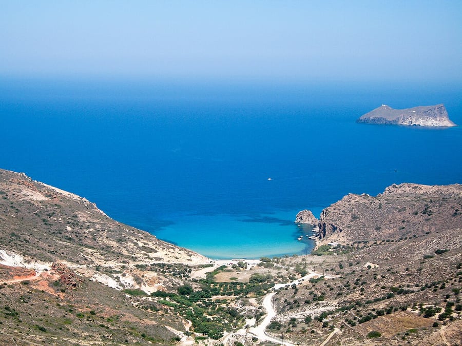
In Greek, the name is written Πλάθιενα. Milos has at least 90 beaches, and 17 of them line the north side. Plathiena beach is one of those 17. Volcanic activity formed Milos, and its rock still covers the larger share of the ground.
From the sand, three names stand out across the water and along the shore. The Akradies are islands off the coast where nobody lives. They belong to the municipality of Milos. Mandrakia, another beach of the north side, also comes into view.
The third name belongs to the Arkoudes, a group of rocky islets, meaning very small islands of rock. In Greek, Arkoudes means bears, and the rocks take shapes that look like bears. They stand about 20 feet high above the sea.
Rare lilies grow on this shore, and a fence closes off the ground where they stand. The same sand marks the start and end of a kayak loop of 4.8 km. On the way, paddlers pass caves and small islands and stop to swim with masks and fins.
- Sand: The shore is a beach of fine, white sand on the north side of Milos.
- Islands: The Akradies lie off the coast, and nobody lives on them.
- Rocks: The Arkoudes take the shape of bears and stand about 20 feet high.
- Plants: Rare lilies grow inside a fenced area on the beach.
- Sea: A kayak loop of 4.8 km leaves from this sand and returns to it.
Plathiena beach comes down to three things: fine white sand, islands and rocks at sea, and rare lilies. Each one gets a closer look in its own section further down. First, though, the beach needs a fixed place on the map of Milos.

Where does Plathiena beach lie on Milos?
Plathiena beach lies on the north coast of Milos, at the western end of that shore. The Arkoudes rocks stand near the beach and near the mouth of the large bay. From Plakes, part of the capital on high ground, the trip down is quick.
Counted from west to east, the north-side row of beaches opens with Plathiena beach. Trachilas comes next, and Firopotamos follows in third place. The row ends far to the east, at Pollonia. Other beaches of Milos line the south, east and west coasts and the inner gulf.
Seen on a map, Milos looks like a horseshoe around a large gulf, meaning a wide bay. This gulf opens to the north-west and reaches deep into the land. The Arkoudes rocks stand near its mouth, and Plathiena beach lies close to them.
Between Plaka and Triovasalos lies Plakes, a small village with white houses and narrow lanes. It was built at the foot of the Kastro, the old castle on the hill above Plaka. From Plakes, Plathiena beach is a quick and easy trip. Together, Plaka and Plakes form the capital of Milos.
Plaka sits on a plateau, meaning flat high ground, at a height of 220 metres above sea level. Triovasalos, Pera Triovasalos and Trypiti share that high ground above Adamas, the main port. The beach, by contrast, lies at sea level on the north shore.
Plathiena beach sits outside the gulf, which holds 25 beaches of its own. It belongs to the outer coast, where the land meets the open Aegean Sea. Those 25 face the inner waters of the bay, a separate part of the coast.
- Coast: The beach opens the row of north-side beaches at its western end.
- Gulf: The large bay of Milos opens to the north-west and splits the island almost in two.
- Rocks: The bear-shaped Arkoudes stand near the entrance of the bay, close to the sand.
- Capital: Plaka stands 220 metres up, with Plakes beside it at the foot of the castle hill.
- Access: The trip from Plakes down to the shore is quick and easy.
On the map, Plathiena beach sits where the north coast begins in the west. The bear-shaped rocks by the mouth of the gulf lie close by. The capital stands on high ground, a short trip away. Later sections follow the road down and the coast on each side.
How do the sand and the sea look at Plathiena beach?
Plathiena beach has fine white sand that meets a crystal-clear, turquoise sea. The shore lies on the open north coast of Milos. Islets and rocks rise from the sea in front of it. The volcanic ground of the island shaped the whole scene.
At Plathiena beach, the shore is made of fine white sand. Fine means the grains are very small, so the sand feels smooth rather than rough. That places it among the sandy beaches of Milos, not among its pebble coves.
Milos has a long list of beaches, large and small, and they do not look alike. Part of them have sand the colour of white gold. Others are bays of pebbles, closed in by white, red, yellow or even black rock.
The reason for this mix lies deep in the ground itself. The soil of Milos is volcanic, and this gave the island its wide mix of shore shapes. Plathiena beach shows the sandy side of that mix, with soft sand in place of stones.
The sea off Plathiena beach is crystal clear and turquoise, a blue with a touch of green. Across Milos, the colour and depth of the sea shift from beach to beach. Each shore ends up with its own shade of blue and its own depth.
Behind the waterline at Plathiena beach, salt from the sea decides what can grow. Almost every beach of Milos has shrubby orache, a bush with blue-green leaves. Rock samphire, another plant that stands up to salt, is common on the shores too.
- Sand: The grains are fine and white, and they feel smooth.
- Sea: The water is crystal clear and turquoise along this coast.
- Shore type: The beach is sandy, unlike the pebble bays elsewhere on Milos.
- Ground: Volcanic soil gave the island its wide mix of beaches.
- Plants: Salt-loving bushes such as shrubby orache grow near the sand.
At Plathiena beach, two things meet: fine white sand and clear turquoise water on the north coast. The volcanic soil of Milos lies behind both of them. The next section turns to the rare plant that hides in this sand through the hottest months.
What are the sea lilies on the sand at Plathiena beach?
Plathiena beach is home to the sea lily, a wild plant with big white flowers. It grows on sandy shores, and on Milos it goes by the Lily of Plathiena. The plant is under threat, so a fence keeps people off its patch.
The sea lily at Plathiena beach has the science name Pancratium maritimum. Despite its common name, it is not a true lily at all. It belongs to the amaryllis family and grows from a bulb, an underground store of food.
The plant lives on beaches and coastal dunes, low hills of sand that the wind piles up. Its second name, maritimum, means “of the sea”, and it also goes by sea daffodil or sand lily. Pancratium comes from two Greek words that mean “all” and “strong”.
On Milos, people call it the Lily of Plathiena, a name taken from this beach. From the end of spring, the plant hides as a bulb deep in the sand. Then, from late July to early September, it opens big white flowers with a faint lily scent.
In autumn, the plant forms seed pods packed with black seeds that weigh very little. Their texture is like pumice, a light volcanic stone full of holes, so they float in sea water. Currents carry them a long way to another beach, where they start to grow.
In the past, the plant grew on every sandy beach of Milos, not just Plathiena beach. Fast building on the coasts of Greece and the Mediterranean over the last 50 years changed its home. Today, across that whole region, the species is threatened with dying out.
- Family: The plant belongs to the amaryllis family, not to the true lilies.
- Home: It grows on beaches and on coastal dunes of sand.
- Flowers: Big white blooms open on Milos from late July to early September.
- Seeds: Light black seeds float on the sea and land on new beaches.
- Pollen: Each flower needs pollen from a different plant to make seed.
At Plathiena beach, a fence closes off the patch where the sea lilies grow. Visitors can look at the flowers, smell them and take photos of them. Cutting a flower or digging up a bulb harms a plant that is already under threat.
What are the rocks and cliffs like around Plathiena beach?
Plathiena beach sits among volcanic rock that shines in metallic shades of red, green and yellow. These colours come from the volcanic past of Milos. Along the nearby coast, sea caves open in the rock and small islands lie just offshore.
Like the bigger share of Milos, the ground around Plathiena beach is volcanic rock. Volcanic activity started between 2 and 3 million years back and ended 90,000 years back. No eruption at all has taken place on the island in recorded history.
Two of the ordinary rocks of Milos are tuff and obsidian, both made by volcanoes. Tuff forms when ash from an eruption settles and hardens into stone, and it stays fairly soft. Obsidian is a volcanic rock that looks like glass and was once shaped into sharp tools.
Across Milos, the volcanic past left sand and rock in shades of red, pink and orange. Other shores show white stone, red stone or ochre, an earthy yellow-brown colour. Steep rock walls that drop into clear water are a common sight around the island.
Each beach on Milos looks different, because its own mix of rocks closes it in. Trachilas, the next beach east of Plathiena beach, shares its name with one of two extinct volcanoes. Extinct means it no longer erupts, and this one lies in the north-north-west of Milos.
Mandrakia, in view from the sand, shows one way people use soft tuff. Boat houses called syrmata are dug into the rock there, right by the sea. At Sarakiniko beach, the rock is white instead and built up in layers, with fossils inside.
- Origin: Volcanic rock covers the bigger share of Milos, this shore included.
- Tuff: This soft stone forms from volcanic ash that settles and hardens.
- Colours: The rocks near the beach give off metallic red, green and yellow tones.
- Neighbour: Trachilas beach, next to the east, shares its name with an extinct volcano.
- Fossils: Shells turned to stone sit inside volcanic rock on Milos.
At Plathiena beach, the white sand sits against rock in red, green and yellow. Each of those tones goes back to the volcanoes that built Milos. Next comes a closer look at the Arkoudes, the rocks that stand in the sea off this shore.
What are the Arkoudes rocks and the coast near Plathiena beach?
Plathiena beach looks out on the Arkoudes, a group of rocky islets whose shapes recall bears. They stand off the coast near the mouth of the bay of Milos. Two islets called the Akradies, one with a lighthouse, sit close by.
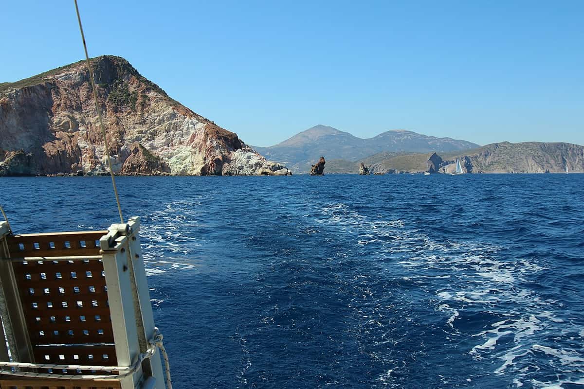
The name Arkoudes is the Greek word for bears. To a watcher at sea, the rocks seem to have a gaping mouth, a nose, ears and eyes. A body completes the picture, and that likeness gave the group its name. The rocks rise about 20 feet above the sea.
From Plathiena beach, the Arkoudes form part of the view out to sea. A close look at the bear faces is possible only from a boat. Boats that tour around the island give that view. The beach shows the wide scene, while the boat shows the detail.
The rocks stand at the way into the bay of Milos. The bay is the hollow left by the chief crater of the island’s volcano. It cuts into the land from the north-west. Its depth falls from about 130 metres to 55 metres. Plathiena beach lies close to this entrance.
Two more islets guard the same entrance, north of Milos and across from Cape Lakida. Together they go by the name Akradies. The larger is Akrathi, also called Megali Akradia. The smaller, Mikri Akradia, lies west of it, 5 nautical miles from the port of Adamas.
The way into the port is tricky for ships. For that reason, Mikri Akradia has carried a lighthouse since 1898. The light stands 7 metres tall. German forces wrecked it in 1941, during the Second World War. It shone again from 1945.
- Arkoudes: The rocky islets rise about 20 feet and look like bears.
- Bay: The sea fills an old volcanic crater that opens to the north-west.
- Akradies: Akrathi and Mikri Akradia are two empty islets at the bay entrance.
- Lighthouse: A 7-metre light has stood on Mikri Akradia since 1898.
- Mandrakia: A village with a beach and a little harbour shows along the coast.
Plathiena beach faces the door to the bay of Milos. The bear rocks, the twin islets and the old light all mark that way in. Both islets now stand empty, though a tiny seaside settlement on Akrathi still had two residents in 2001.
How do visitors get from Plaka down to Plathiena beach?
Plathiena beach is a quick, easy trip from Plakes, a village right beside Plaka. Both villages stand on high ground above the harbour, so the route heads down toward the sea. Dirt roads and a small fleet of taxis serve the island.
Plaka, the chief town of Milos, stands on flat high ground above the harbour. A road climbs to it from the port town of Adamas. Above the houses rises the Kastro, the hill of the old castle. The beach lies below, on the north coast.
Plakes sits beside Plaka, and the two villages together form the capital. The name Plakes means flat ground, since the land there is level. From this village, the trip down to Plathiena beach is quick and easy. That makes Plakes a handy place to start.
A road also links Plaka with Firopotamos, a beach and village on the north coast. Away from the paved roads, Milos leads the Cyclades for dirt roads. Its unpaved tracks run out to coastal spots, chapels and old mines. On certain stretches the going turns very hard.
Not every visitor drives. The island has 15 taxis, and they can be found at the port and the airport. The cars are fairly new, roomy and air-conditioned, and a handful even offer wireless internet. City buses serve only certain parts of Milos. A check before the trip shows if one stops near Plathiena beach.
At Plathiena beach, a fence rings the plot where rare lilies grow. Walkers keep to the open sand and step around it. Nothing inside the fence is cut, dug up or trampled. The plants stay there for everyone to see.
- Start: The trip from Plakes to the beach is quick and easy.
- Height: Plaka and Plakes stand on flat high ground above the harbour.
- Tracks: Dirt roads lead out to coastal spots, chapels and old mines.
- Taxis: Fifteen cabs work the island, waiting at the port and the airport.
- On the sand: Walkers stay outside the fence around the lilies.
The way to Plathiena beach starts on the high ground of the capital and ends at sea level. Plakes gives a quick start, and taxis serve visitors without a car. Once on the sand, the fenced lilies set the line for every step.

What shade and facilities does Plathiena beach have?
Plathiena beach has a beach bar, and it serves refreshments to visitors. Its fine white sand also holds a fenced patch of rare lilies. Across Milos, beaches range from fully organised to wild and quiet. A plan for shade helps.
The bar also marks the end of the kayak and snorkel loop that sets out from Plathiena beach. Paddlers land on the sand and stop there for refreshments. For anyone on the beach, it saves a trip back up to the villages for a drink.
On Milos, a fully organised beach lines its sand with sunbeds and umbrellas. A wild beach offers only rock, sand and sea. Between the two sit beaches with one or two services. A quick check of what a shore holds helps visitors pack the right kit.
Trees that grow by the sea on Milos must cope with salt. The tamarisk is one of them, a small tree that can reach 7 metres. On other beaches of the island, groups of tamarisks give natural shade. Where no trees stand, shade comes from a sun umbrella.
Visitors who bring a sun umbrella set it up on the open sand of Plathiena beach. Through late spring and early summer, until the flowers open, the lily bulbs lie deep below the surface. A pole driven into the fenced ground harms them. Bags and towels stay outside the fence too.
The beach lies on the north side of Milos. A north wind blows straight in from the sea. On meltemi days, a loose umbrella can lift in a gust. Visitors push the pole deep into open sand and keep the canopy low. A shirt and a hat give simpler cover.
- Bar: A beach bar on Plathiena beach serves refreshments.
- Kayaks: The paddling loop starts and finishes on this sand.
- Trees: The tamarisk, a small tree that copes with salt, shades other Milos beaches.
- Lilies: A fence protects a patch of rare sea lilies.
- Umbrellas: Poles go into the open sand, well clear of the fence.
A day on Plathiena beach rests on the bar, the fine white sand and the fenced lilies. A hat, water and a sun umbrella complete the kit. The umbrella goes up on open sand, well away from the bulbs.
How do the wind and calm days shape a swim at Plathiena beach?
Plathiena beach lies on the north side of Milos, in the path of the north wind. On meltemi days, swimmers do better inside the bay or on the south coast. When the wind turns and blows from the south, the north beaches become the better choice.
At Plathiena beach, the main summer weather force is the meltemi, a strong, dry wind of the Aegean. Across the central Aegean, its air pours down from due north. In the southern Aegean it bends to the north-west, and the weather under it stays fine and clear.
Its ancient name, the etesians, means the yearly winds, since the wind comes back every summer. Light north breezes, called the forerunners in Greek, open the season in late spring and then pause. The full meltemi follows and blows until early October, at force 6 to 7 on average.
Plathiena beach feels the meltemi hardest in the afternoon, when the wind reaches its peak. At night it tends to fade, yet a strong spell can last for days on end. Through it all the sky stays clear, while the water turns choppy with waves.
Strong meltemi days can stop small boats from sailing, and the hottest hours bring the worst of it. The air behind the wind starts over southern Russia and dries out on its way across Europe. From Plathiena beach, the sky turns deep blue, the far horizon looks crisp, and the heat eases.
A wind from the south, the opposite of the meltemi, turns the whole picture around. On those days, swimmers pick the north beaches, and Plathiena beach is one of them. The bulk of Milos then stands between the wind and this north shore.
- Meltemi: a strong, dry summer wind that crosses the Aegean from the north.
- Season: light breezes in late spring, then the full wind until early October.
- Daily peak: gusts peak in the afternoon and tend to ease at night.
- North wind: swimmers move to the bay or the south coast.
- South wind: the north beaches, this one among them, become the better pick.
A look at the wind is the first step before a day at Plathiena beach. A north wind sends swimmers south or into the bay, while a south wind brings them back here. The same check counts for a paddle, since a hard meltemi halts small boats.
What do snorkellers and kayakers find at Plathiena beach?
Plathiena beach gives snorkellers clear water and a rocky coast with sea caves and small islands. It is also the start and finish of a kayak loop of 4.8 km. That loop pairs the paddle with a snorkel inside a group of caves.
A snorkeller floats face-down and breathes air through a bent tube, the snorkel. A mask gives a clear view under the surface, and fins add push with each kick. The kit is simple, no scuba training is needed, and the low effort suits swimmers of all ages.
A good snorkel spot has warm water, low waves and sights to watch close to the surface. At Plathiena beach, the water is clear, and the coast nearby breaks into caves and small islands. For low waves on this north shore, a south-wind day is the one to choose.
Passing boats and jet skis pose the main risk, since only the tube shows above the water. Bright clothing or a float with a dive flag helps boat crews spot the swimmer early. A rash vest or a T-shirt guards the back and the legs against sunburn.
A sea kayak is a paddle-driven boat made for open water, from sheltered bays out to the sea. On Milos, day trips by kayak run in the months from April to October. Part of the island’s shoreline opens only to those who come by sea, and kayaks reach it.
The Plathiena kayak and snorkelling route is a loop of 4.8 km from Plathiena beach. Paddlers pass caves and islets, then leave the boats in a cave and swim with masks. After a rest at Nerodafni, they head back past the Arkoudes rocks to the same sand.
- Snorkel kit: a mask, a bent breathing tube and a pair of fins.
- Depth: shallow reefs of one to four metres let a swimmer float over without kicking the bottom.
- Safe swim: a partner close by and a hands-off look at sea life keep the outing safe.
- Kayak season: the paddling months on Milos stretch from April to October.
- Route: the loop starts and ends on the sand of Plathiena beach.
Plathiena beach brings the two sports together on one stretch of coast. Kayaks launch from its sand, and the snorkel stop waits among the caves along the loop. Both need a quiet sea, so a check of the wind comes first on any day spent here.
Which beaches lie close to Plathiena beach on the north coast?
Near Plathiena beach, the north coast runs east past Trachilas, Firopotamos, Tourkothalassa and Mandrakia. Trachilas is a lonely beach at the end of a dirt road. Firopotamos and Mandrakia are small fishing villages with boat houses. Tourkothalassa has sand and pebbles out of the wind.
Plathiena beach marks the western end of the north coast. Heading east, the shore passes Trachilas, Firopotamos, Tourkothalassa and Sykia, also called Afalatosi. Mandrakia comes sixth in that row. Seventh is Sarakiniko, the beach known for its white volcanic rock. Ten more beaches follow, and the row ends at Pollonia.
Trachilas, a lonely beach, is the next stop east of Plathiena beach. The way in starts on the road from Plaka toward Firopotamos. Shortly before that village, a side road climbs left and becomes a dirt track to the beach. The name Trachilas also belongs to one of two extinct volcanoes on Milos.
Counting from Plathiena beach, Firopotamos comes third. It is a fishing village on a small bay, with Plaka 3 km to the south. The village became an official settlement in its own right in 1920. Its sandy beach is organised, with tamarisk trees, and suits swimming and fishing.
Its small harbour wraps around a natural cove lined with boat houses called syrmata. They are dug into the volcanic rock right by the water. Boats rest inside them through the winter, and owners turn them into summer homes. Only 2 people lived in Firopotamos at the 2021 census, down from 4 in 2011.
Mandrakia is part of the view from Plathiena beach. This old fishing village lies about 4 km north of Adamas, the main port. Its quiet beach runs for about 150 metres, with fine, dark grey pebbles and tamarisk trees. The church of Zoodochos Pigi stands above its colourful boat houses.
- Tourkothalassa: Sand and pebbles meet clear blue water on a shore out of the wind.
- Syrmata: The word recalls fishermen dragging their boats from inside down to the sea.
- Loading ladder: At the far end of the Firopotamos cove stands a disused loading ladder.
- Dirt roads: Milos has the biggest web of dirt tracks of any Cycladic island.
- Mandrakia today: The 2021 census counted 13 residents in the village.
The coast east of Plathiena beach holds four different kinds of stop. Trachilas means a dirt road and a lonely shore. Firopotamos and Mandrakia bring small harbours and colourful boat houses. Tourkothalassa keeps its sand and pebbles out of the wind. The white rock of Sarakiniko lies just past them.
What is there to see in Plaka, the town above Plathiena beach?
Above Plathiena beach stands Plaka, the main town of Milos, at a height of 220 metres. Cars stay out of its narrow lanes. A castle built by Venetians in the 13th century sits at the top. Its view takes in the bay and nearby islands.
Up the hill from Plathiena beach, Plaka serves as the capital of Milos. Officially, it carries the name Milos. It became the seat of a new municipality in 1835, under the name Plaka. The name changed to Milos in 1912. The municipality it heads covers the island and the rocky islets close by.
The name Plaka refers to flat ground. Homes spread onto that level land when the castle ran out of room. The town first took shape on the flat ground just below the castle. Plaka grew after people left the older capital, Zefyria, also called Chora. For that reason, Plaka itself is not called Chora.
The stone-paved lanes were first laid out as a guard against pirates. Walls and houses stand so close together that no car fits between them. Only motorbikes and mopeds get through. Small traditional shops and cafes open onto the lanes. Plaka was declared a traditional settlement in 1978.
The castle crowns the highest point of Plaka. Its hill is a volcanic dome, formed from lava that hardened before it spilled out. Venetian rulers raised it in the years after 1204. The height gave a clear watch over ship traffic in the bay of Adamas. Today the castle is a protected monument.
From the castle top, the view sweeps over the bay and on to nearby Cycladic islands. Evening skies there turn rich in colour. The castle is also a viewpoint for the best sunset in Milos. Plathiena beach sits close to the mouth of that bay, near the bear-shaped Arkoudes rocks.
- Mesa Panagia: Dedicated to the Dormition, this church sits on the castle summit.
- Korfiatissa: Built in 1820, the main church of Milos is a protected monument.
- Museums: Plaka holds the archaeological, folklore and war museums.
- War years: German troops fortified the castle in the Second World War, as at Trachilas.
- Plakes: This village between Plaka and Triovasalos gives quick access to Plathiena beach.
Plaka and Plathiena beach show two sides of the same corner of Milos. The beach sits at sea level on the north shore. The hill town adds the castle, the churches, the museums and the long view over the bay. A day can start on the sand and end in the lanes above.
When is the best season for a visit to Plathiena beach?
Plathiena beach is at its busiest in the hot, dry summer months. Milos draws its peak number of visitors then. Late spring and early autumn give warm, dry days with fewer people. The cool, wet winter suits a walk on the sand, not a swim.
Milos has a Mediterranean climate. Its summers are hot and dry, and its winters are mild and wet. From June to September, a day with real rain comes less than once a month. For a swim at Plathiena beach, that gives a long, settled season.
July is the hottest month. Daytime highs reach about 28 °C, and nights stay near 22 °C. August runs only a little cooler. These are also the weeks when Milos fills with summer visitors. The sand sees its largest crowds then.
Summer on the Aegean belongs to the meltemi, a strong and dry wind from the north. It sets in during late spring and drops away by mid-September. The wind gains strength through the day and eases after dark. On this north-facing shore, calm water comes early, before the wind builds.
April averages highs near 18 °C. By late spring, highs reach almost 23 °C. Rain then falls on only one or two days a month. Plathiena beach stays quiet in these weeks. The sea lilies show only grey-green leaves, as their flowers come later in the year.
September keeps the feel of summer, with highs near 25 °C and almost no rain. October cools a little, and rain returns on about four days in the month. The white lily flowers still open into October, so autumn visitors can see them.
- High summer: July and August are the hottest and busiest weeks on the sand.
- Late spring: Warm days and little rain come before the summer rush.
- Early autumn: September stays warm and dry, and the lily flowers open into October.
- Winter: December is the wettest month, with rain on about nine days.
- Time of day: Early hours bring calmer water than the windy afternoon.
For a swim at Plathiena beach with room on the sand, late spring and September stand out. High summer adds heat, wind and crowds, while the cool, wet months fit a walk. A separate article on the best time to visit Milos covers each month in turn.

What goes in the bag for Plathiena beach, and how is the shore protected?
Plathiena beach needs drinking water, a hat, sun cream and sandals for hot sand. Every scrap of litter leaves with the visitor who brought it. Feet, towels and umbrellas stay outside the fenced sea lily plot. They also keep off the dunes, where the plant lies half-buried.
Summer on Milos is hot, and June has the driest air of the year. Plant cover is thin, as the island is too dry for lush growth. Each person needs a large bottle of water at Plathiena beach.
The summer sun is strong. A wide hat, sun cream and a light shirt protect the skin around midday. Sand grows hot enough to hurt bare feet, so light sandals or water shoes join the pack. They also grip better on wet stones at the water line.
Every bottle, can, wrapper and cigarette end goes home in the bag it came in. Litter left on the sand does not stay put. When the north wind rises, it carries loose rubbish into the dunes and out to sea. There it harms plants and sea life.
The sea lily, a white-flowered plant of sandy shores, grows here inside a fenced plot. Its leaves and flower stems sit half-hidden in the sand. One careless step on the dune can crush parts of the plant that nobody sees. Picking a flower ends its chance to make seed.
Along Mediterranean coasts, the plant is under heavy pressure. Tourist building and damage to shore habitats have cut its numbers. In wide areas, it counts as threatened. Its seeds float on sea currents. A healthy plot at Plathiena beach can therefore seed other shores.
- Drinking water: A large bottle for each person on hot, dry days.
- Sun cover: A hat, sun cream and a light shirt guard the skin.
- Footwear: Sandals or water shoes protect against hot sand and wet stones.
- Rubbish bag: A spare bag takes every scrap of litter back home.
- Lily plot: Feet, towels and umbrella poles stay outside the fence and off the dunes.
Simple gear and careful steps leave Plathiena beach as clean as it was found. The same habits fit a paddle, a boat trip or a walk inland. For the rest of the trip, a wider list of activities in Milos sets out the options.
What do first-time visitors ask about Plathiena beach?
Plathiena beach suits families on calm days, and its fine white sand is easy on small feet. A hat and water matter above all in summer. North wind brings waves to this shore, while Plaka, the main town, pairs well with a morning swim.
Is Plathiena beach a good choice for children?
Fine white sand makes the shore easy for small children to play on. Calm days suit young swimmers best, since a strong north wind sends waves onto this north coast. A hat, sun cream and plenty of water matter in summer. The fenced lily plot teaches a simple lesson: look, but never touch.
Where does shade come from at Plathiena beach?
Milos is too dry for thick plant growth. On a summer day, a hat, a light shirt and a beach umbrella are the surest shade. In July, afternoon highs average about 28 °C. Early morning and late afternoon are the coolest times on the sand. Umbrella poles go into open sand, outside the lily fence.
Where do drivers leave a car at Plathiena beach?
Cars and motorbikes stop on firm ground off the beach and never roll onto the sand. Below the surface of the dunes lie the bulbs and buried leaves of the sea lily. Wheels crush them without anyone seeing the harm. In the busy summer months, an early start makes parking easier.
Can visitors buy food and drink at Plathiena beach?
A beach bar stands on the shore and serves refreshments, so a drink is close at hand. A full meal is easier to find in the villages on the high ground. Plaka, for one, has small shops, cafés and places to eat. Water and a snack from home still help on a long stay.
What happens at Plathiena beach on a windy day?
On a strong north wind, the sea along this coast turns choppy, and swimming loses its appeal. The gusts build after lunch and fade once night falls. Beaches that face south sit in the shelter of the land on such days. A calm morning on the north shore remains the other option.
What is the evening light like at Plathiena beach?
Evenings bring softer light and, in summer, a falling wind. After a day of north wind, the sky turns deep blue and the air stays clear. The Arkoudes rocks and the Akradies islands then stand out sharply. On still summer nights, a faint scent drifts from the fenced sea lily plot.
Which photos do visitors take at Plathiena beach?
Fine white sand, the Arkoudes rocks and the empty Akradies islands fill the frame. Mandrakia also sits in view along the coast. From late summer into October, the white lily flowers add a close-up subject. Every lily shot is taken from outside the fence, with no step onto the plot.
Can Plathiena beach and Plaka fit into one day?
Yes. A morning swim, in the calmer hours, leaves the afternoon free for Plaka. The main town looks down on the gulf from 220 metres above the sea. Car traffic is banned inside the village, so visitors explore on foot. The castle hill above the town and the archaeological museum fill the rest of the day.