A map of Milos shows an island that is easy to read. The land bends around one large gulf, the villages gather on the high ground above it, and the far west stays empty. This page reads the map of Milos in two steps, outline first and regions second. The wider setting is in the overview of the island.
The outline comes first because every feature on the map of Milos hangs from it. The regions follow in a fixed order: the hill villages, the port, the north-east, the south and the west. Each one lies at a set place against the gulf, so a reader who knows the outline finds the rest at once.
What does the shape of the island show on a map of Milos?
A map of Milos shows a horseshoe about 23 kilometres long and 13 wide. A deep gulf cuts in from the north-west and splits the land into an east half and a west half, joined by a neck of land no wider than 2.2 kilometres.
The gulf is the centre of every map of Milos. It fills the hollow of the main crater, and its depth diminishes from 130 metres to 55 metres along its length. That deep water gives the island its horseshoe outline and forms a large natural harbour with a safe anchorage. The mouth of the gulf faces north-west. The site of the old Dorian city lies on the eastern shore of the bay, just south-west of Trypiti.
Size sets the scale of a map of Milos. The area of the main island is estimated at 151 square kilometres, which makes Milos the fifth largest island of the Cyclades and far larger than the islands beside it. Kimolos lies 1.6 kilometres off the north-east side and covers 36 square kilometres. Polyaigos lies 2 kilometres south-east of Kimolos and is also uninhabited. A full municipal map also adds the islands of Antimilos and Akradies.
The two halves of a map of Milos differ in what they hold. The east half carries the harbour town, the capital on its plateau, Zefyria in the inner part, Pollonia at the tip and the obsidian hills of Sta Nychia and Demenegaki. The west half rises to Mount Profitis Elias at 748 metres. Almost all of the uninhabited west is a Natura 2000 site with over 800 taxa, and 35 of them are endemic to Greece.
- Rock types: Tuff, trachyte and obsidian are the ordinary rocks.
- Rock colours: The volcanic rock carries white, red, yellow and black colours.
- Volcanic age: Activity began 2 to 3 million years ago and last erupted 90,000 years ago.
- Hot ground: Hot sulfurous springs rise on the eastern shore, and one south-coast cave is still hot.
- Antimilos: This uninhabited mass lies 21 kilometres north-west and still shows its crater.
Seen as a whole, the outline gives the map of Milos three fixed anchors: the gulf in the north-west, the narrow neck between the halves and the high ground in the west. The volcanic past explains each of them, from the crater hollow to the hot springs. The next section places every region of the island against these anchors, one by one.
Which regions of the island does a map of Milos show?
A map of Milos shows five regions: the hill villages above the port, the port itself, the north-east around Pollonia, the south coast and the empty west. Each region has a fixed place against the gulf, so the five are easy to tell apart.
The first two regions of a map of Milos lie on the same side of the gulf. The capital stands on the plateau above the water and is made of two settlements, Plaka and Plakes. Triovasalos, Pera Triovasalos and Trypiti share the same height. Refugees from Crete founded Adamantas, the port below, in 1841. Five communities make up the municipality, which covers the whole island: the four hill communities merged in 1986, and Adamantas joined them in 1998.
The north-east tip of a map of Milos holds Pollonia, the second harbour, and the Bronze Age settlement of Phylakopi lies on the same coast. A regular small-boat link joins Pollonia to Kimolos across the short stretch of water, and the village belongs to the community of Triovasalos. The south coast faces the Sea of Crete and holds beaches such as Kleftiko, Palaiochori, Fyriplaka and Gerontas. The small settlements of Provatas and Palaiochori stand on it too.
On a map of Milos, the west is the empty region. Rugged, hilly ground fills the greater part of the island, and the western half has no village. The land is too dry for a profusion of vegetation, although orange, olive, cypress, tamarisk, juniper and arbutus trees grow throughout the island. Grapes, cotton and barley are the main crops of the island. The coast of the west half holds only coves, named in the list below.
- Hill villages: Trypiti stands beside the Catacombs and the Roman theatre.
- Port: Adamantas holds the French cemetery and the church of the Holy Trinity.
- North-east: Pollonia has a sandy main beach, with Polychroni and Piso Thalassa nearby.
- South: Provatas lies 7 kilometres from Adamas on a paved road, with golden-red sand.
- West: Sykia, Triades, Agkathia, Kalogries and Ammoudaraki are the named coves.
Taken together, the five regions turn the map of Milos into a simple frame: the hill villages and the port on one side of the gulf, then the north-east tip, the south coast and the empty west. Each region has its own pages on the site, from villages and beaches to sights and museums, and all of them start from the pages about Milos.

What does the map of Milos show about its roads?
The map of Milos shows paved roads from Adamas to the plateau villages, the east and Pollonia, and a network of dirt tracks that takes over in the west, where no village stands and directions run by monasteries and crossroads.
Adamas is the starting point on the map of Milos, and the main road to Plaka leaves the port to the north. It continues north-west to Tripiti, where the downhill concrete road stops in a parking area after 700 metres. The catacombs lie beyond it, reached on foot among old olive trees. A coastal road leaves Adamas to the east and passes the old salt works of Alykes just before the airport. Paved roads on the map of Milos reach the car park, and the walk begins there.
Zefyria stands in the centre of east Milos, 5.5 kilometres from Adamas and 9 kilometres from Plaka. Pollonia, the second port of Milos, lies at the north-eastern tip, almost 10 kilometres from Adamas and 14 from Plaka. Kapros is visible from the main road to Pollonia. From the beach of Pollonia, where the buses stop, an asphalt road runs south and south-east towards Voudia. These four distances give the scale of the paved network on the map of Milos.
The west half of the map of Milos holds no village, only a minimal number of settlements and old mines. The dirt road network of the island is the largest in the Cyclades, and the beaches of the west lie at the end of it. From Achivadolimni the main road meets the monastery of Agia Marina. A right turn at the second crossroads beyond it leads to Agkathia, and a right turn past the monastery of Agios Ioannis Siderianos leads to Ammoudaraki.
- Provatas: a paved, well-signed road runs 7 kilometres from Adamas, and buses serve it.
- Papikinou: this large beach lies 1 kilometre east of Adamas.
- Fatourena: a dirt road from Agia Marina descends to a quiet beach facing the port.
- Agios Ioannis: a dirt road of about 12 kilometres leads there, and only the first part suits cars.
- Patrikia: a dirt road leads near, and the last stretch is on foot.
The roads of the island can be read in one pass on the map of Milos: the paved spine runs from Adamas to the plateau, the east and Pollonia, the coastal road runs east past the salt works, and the dirt tracks take the west. The island measures 23 kilometres from east to west and 13 kilometres from north to south, so the distances between villages stay short.


How does the map of Milos place the coasts and beaches?
The map of Milos sorts the coast into five groups: north, south, east, west and inside the gulf. Roads and buses reach the north, south and gulf shores, the west needs dirt tracks, and the farthest coves need a boat.
On the map of Milos, the north group runs from west to east and ends at Pollonia. Sarakiniko is easy to reach by car and by bus, and Pollonia by car and public transport. The east group starts just south of Pollonia with Kastanas, a wild beach with no sand, only small coloured pebbles and rocks in red, orange and purple. Tria Pigadia, a small, rocky and remote beach on the east side, lies between Kastanas and Agali.
The south group of the map of Milos reads from east to west and ends at Kleftiko. Paleochori is almost 2 kilometres long. A relatively easy dirt road leads to Tsigrado, and a steep path covered with sand leads down to the beach. Kipos has a small port from which boats leave for Kleftiko, and Kleftiko itself, a set of grey and white rocks with caves, is reached by boat or sailboat. The south coast therefore mixes road, path and sea access.
The cave of Sykia in the west has no roof and opens only from the sea, and the western beaches are remote. Inside the gulf, Lagkada is the nearest beach to the port of Adamas, and Achivadolimni, the largest beach on the island, divides into two sandy beaches and is served by buses. Agios Dimitrios at the west end of the bay can only be reached by boat. The map of Milos places the gulf beside the port and the west far from any village.
- North: Plathiena, Firopotamos, Mandrakia and Papafragas complete the shore west of Pollonia.
- South: Agia Kyriaki, Firiplaka and Gerakas lie between the east end and Kleftiko.
- East: Voudia, Rema, Kolympisionas and Theiorycheia line the rest of the east coast.
- West: Triades and Kalogries are secluded beaches in the wild western half.
- Inside the gulf: Rivari, a lagoon beach, and Empourios, an old commercial port, sit on the bay.
The five groups and the roads decide each other: paved roads and buses serve the north, the south and the bay, dirt tracks serve the west, and boats serve the coves that no road reaches. A reader of the map of Milos can match each shore to a road before choosing among the beaches of Milos, which lie on all four sides of the island.
How does the map of Milos show Kimolos, Polyaigos, Antimilos, Glaronisia and Akradies?
The map of Milos places Kimolos just north-east across a narrow channel, Polyaigos further east, Antimilos out to the north-west, and Glaronisia and Akradies off the northern coast, with small rock islets scattered between Milos and Polyaigos.
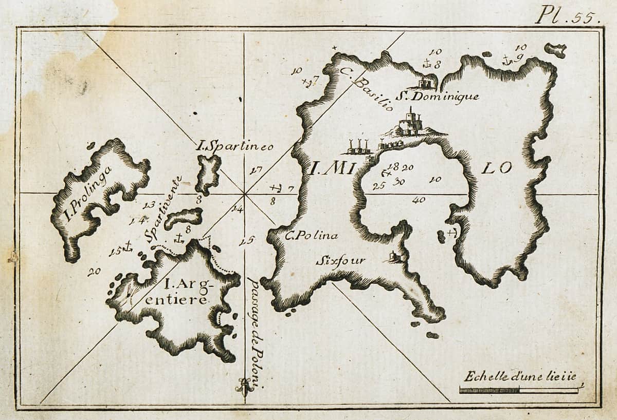
On the map of Milos, Kimolos is the nearest neighbour. It lies north-east of Milos, split from it by a channel 1 km wide, and it covers 36 square kilometres. Polyaigos comes next to the east. It stands 2 km south-east of Kimolos and 6.2 km from Milos, and its area is about 18 square kilometres. Between Milos and Polyaigos lie the rock islets Kasseles, Agios Georgios, Manolonisi and Agios Efstathios, and Agios Efstathios faces Psathi, the harbour of Kimolos.
Antimilos stands apart from the rest. The island sits north-west of Milos, in open water, and covers 8.801 square kilometres, less than half the area of Polyaigos. It is an uninhabited mass of trachyte, and its volcanic crater is still obvious. Locals call it Erimomilos, the Desert Milos. On the map of Milos, Antimilos reads as a lone volcano, away from the chain of islands that runs east and north-east of the main island.
Glaronisia and Akradies fill the northern edge. Glaronisia is a group of uninhabited islets north of Milos, facing the seaside settlements of Pachaina and Agios Gerasimos. Pachaina stands about 9 km west of Plaka, the seat of the municipality, and its beach looks north-west toward the islets. Akradies are two islets at the entrance of the bay of Milos. The smaller one, Mikri Akradia, lies west of the larger Akrathi and 5 nautical miles from the port of Adamantas.
- Size: Milos measures about 23 km from east to west and 13 km from north to south.
- Sifnos: Kimolos lies 7.5 nautical miles south-west of it, and Polyaigos lies 8.8 nautical miles south-west of it.
- Folegandros: Polyaigos lies 11.5 nautical miles north-west of this island.
- Peaks: Paleokastro on Kimolos reaches 364 metres, and Psilo Vouno on Polyaigos reaches 370 metres.
- Polyaigos coast: Manolonisi lies off the west side of the island, and the Kalogeroi islets lie off the south.
Read as a whole, the map of Milos spreads the islands in three directions. Kimolos, Polyaigos and the rock islets form a chain to the east and north-east. Antimilos stands alone in the north-west. Glaronisia and Akradies sit along the northern coast. Cruises from Pollonia start in the north-eastern part of Milos, the side where Kimolos lies, and a small boat also links that village with Kimolos.

What do readers ask about the map of Milos and its islands?
The map of Milos raises six frequent questions about borders, distances and position. The answers below cover Kimolos, the uninhabited islands, Antimilos, Akradies, Polyaigos and the place of Milos in the Cyclades, with every distance given in kilometres, miles or nautical miles.
Is Kimolos a separate municipality on the map of Milos?
Yes. Kimolos is the administrative centre of its own municipality in the Cyclades. The municipality covers 53.251 square kilometres, against 36 square kilometres for the island itself, and the 2021 census reported a population of 810. Milos forms a different municipality, although a channel 1 km wide separates the two islands.
Which islands on the map of Milos have no residents?
Antimilos, Akradies, Glaronisia, Polyaigos, Agios Efstathios and Agios Georgios are uninhabited. Antimilos and Akradies belong to the municipality of Milos, which covers 160.147 square kilometres and counted 5,193 inhabitants in the 2021 census. Glaronisia belongs to the community of Triovasalos, within the same municipality. The other three belong to the municipality of Kimolos.
Where is Antimilos on the map of Milos?
Antimilos is a Cyclades island north-west of Milos, in open water, while Polyaigos stands 6.2 km from Milos and Kimolos lies across a channel 1 km wide. The island rises to 671 metres above the sea, and administratively it is part of the municipality of Milos. Nobody lives on the island.
Where do the Akradies islets appear on the map of Milos?
Akradies is the shared name of Akrathi, also called Megali Akradia, and the smaller Mikri Akradia. Both stand north of Milos, opposite Cape Lakida, at the entrance of the bay. The pair also appears as Akradia or Akrathies, and the official name of Akrathi is Akrathion. Neither islet has residents.
Is Polyaigos on the map of Milos inhabited?
No. Polyaigos is the largest uninhabited island of the Aegean, and its name points to the goats that graze there. The Greek Orthodox church owns much of the island and sublets parts to herdsmen from Milos and Kimolos. Caves at sea level shelter a dwindling population of Mediterranean monk seals.
Where does the map of Milos place the island in the Cyclades?
Milos is the island at the south-western end of the Cyclades, in the Aegean Sea just north of the Sea of Crete. It lies 120 kilometres due east of the coast of Laconia. Kimolos lies 150 kilometres south-east of Piraeus, and Milos, Kimolos, Polyaigos, Antimilos and the surrounding islets form the cluster that closes the group in that direction.