- Villages of Milos: Adamantas, Plaka, Pollonia, Tripiti, Triovasalos, Zefiria
- Fishing Village of Milos: Klima, Fyropotamos, Mandrakia
- Beaches of Milos
- Museums of Milos: Archaeological Museum, The Folklore Museum, Mineral Museum, Church Museum, Naval Museum
- Sights: Refuge Project, Catacombs of Milos
This page collects facts about Milos and goes deeper than the general Milos travel information on the home page. It follows the island place by place and subject by subject, from the ancient name to the villages, ruins, churches, islets, wildlife and economy of the island. The municipality covers the island and the islets around it, and every section stays inside that area.
The first two sections deal with the basics. The first explains where the name Melos comes from and why an apple appears on the ancient coins of the island. The second covers the people of Milos today, the municipality and its communities. What is known about Milos beyond these basics is split into short sections, so that each village, site and subject has its own place.
What do the name Melos and the apple coins reveal about Milos?
Facts about Milos start with its name. The island was Melos in ancient Greek, and the ancient Greek word for apple, mêlon, sounded like it. From the 6th century BC until 416 BC the island struck coins with an apple and the word ΜΑΛΙΟΝ, meaning of the Melians.
The island has two English spellings, Milos and Melos. Milos follows the modern Greek form Μήλος, read as Mílos. Melos follows the ancient Greek form Μῆλος, read as Mêlos. Melos is also the name of the Dorian settlement and of the island during the siege of 416 BC. Both names point to one island and one people, so the ancient story of Melos is also the story of Milos, and it is the first thing to know about Milos in antiquity.
The apple on the coins is a pun. The ancient Greek word for apple, mêlon, sounded like the name of the island, so the picture of the fruit and the name of the place matched. The majority of the coins bore the apple, and the name of the fruit is identical to the name of the island. The apple therefore became the emblem of the island on its ancient coinage, a plain fact about Milos that the name itself explains.
From the 6th century BC until the siege of 416 BC, Melos issued its own coinage on the Milesian weight standard. The base coin was the stater, which weighed just over 14 grams. Melos was the only island in the Aegean Sea to use this standard. Coins also named the people as ΜΑΛΙΟΝ or a shorter form of it, which reads as of the Melians. This is what the coins say about Milos in its own voice.
The separate coinage ended with the loss of independence. Athens captured the city in the winter of 416 BC, and Sparta expelled the Athenian settlers in 405 BC. After that the coinage switched to the Rhodian standard, with tetradrachms of 15.3 grams, and the word ΜΑΛΙΟΝ no longer appeared. The local script, an archaic variant of Greek writing, was dropped after the siege, and the terracotta reliefs also stopped. These three local traits show what was distinct about Milos before 416 BC.
- Spellings: In Greek, Milos is written Μήλος in the modern form and Μῆλος in the ancient form.
- Sheep tradition: A saying holds that the name comes from bēlos, which became mēlos and meant sheep.
- Second name: The uninhabited Antimilos, north-west of Milos, is also called Erimomilos, which means Desert Milos.
- Writing: The Melians used an archaic variant of the Greek script by the 6th century BC and discarded it after 416 BC.
- Terracotta: Melian reliefs with mythological scenes decorated doors and chests and were exported from at least 470 BC.
The apple coins belong to a short period of independence. In 480 BC the Melians refused to submit to Persia and sent two warships to the Greek fleet at Salamis. In 416 BC an Athenian army of 3,400 men besieged the city and took it. The free story of Milos from those years ends with new settlers and a new coin type, and the facts about Milos after 416 BC begin with the Athenian settlers. The next section turns from the ancient city to the people of the island today.
What are the population facts about Milos and its communities?
Figures about Milos today put the population of the municipality between 5,193 and 5,302 inhabitants in 2021. The municipality covers the island and the islets around it, and it is divided into five communities: Milos (Plaka), Adamantas, Pera Triovasalos, Triovasalos and Trypiti.
The municipality of Milos covers the island of Milos and the islets around it. The Kallikratis programme, which set a new administrative division of the country, left the municipality unchanged. Four islets lie inside the municipality: Akrathi, Ananes, Antimilos and Paximadi, and each of them has zero residents. The population is therefore counted only in the villages and settlements of the main island, and every number about Milos below refers to those places.
Every settlement has its own 2021 count, so the numbers about Milos can be read village by village. The port of Adamantas had 1,268 residents. Triovasalos had 1,379 in its community, Pera Triovasalos 987 and Trypiti 766. The community of Milos, centred on Plaka, had 902. Triovasalos holds the largest community total, although Adamantas is the largest single settlement, since the village of Triovasalos itself counted 1,001 and the village of Pera Triovasalos 844.
The 2021 total for the municipality lies between 5,193 and 5,302 inhabitants, and the higher number equals the five community figures added together. Earlier points show a larger population in the past: the population peaked in 1928 at 6,562 people and stood at 4,977 in 2011. These figures about Milos show a fall of 1,585 people between 1928 and 2011, so the island holds fewer inhabitants today than it did in 1928.
Smaller settlements follow the larger ones. The figures about Milos at this level are small: Trypiti village has 502 residents, Pollonia 268, Zefyria 190, Klima 8 and Kipos 3. The capital, Triovasalos, Pera Triovasalos and Trypiti stand on high ground above Adamantas. The western half of the island has no villages, only a very small number of settlements and old mines, so the places named above hold the population of the island.
- Capital: The capital is called Milos and is made of two settlements, Plaka and Plakes.
- Religion: The majority of the population was and still is Greek Orthodox, a basic fact about Milos.
- Sister island: Shōdoshima in Kagawa, Japan, is the sister island of Milos (1989).
- Early figures: The philosopher Diagoras and the poet Melanippides, both of the 5th century BC, are among the notable people of Milos.
- Later figures: Antonio Millo, a captain and cartographer, and Antonio Vassilacchi, a painter, are also among the notable people of Milos.
The island is counted by settlements, communities and islets, and it forms one municipality. Taken together, these figures show a small population spread across a long series of places. The sections that follow, with the facts about Milos, are organised the same way, place by place, starting with the port of Adamantas and the capital Plaka and continuing with the villages.


What are the facts about Milos at the port town of Adamantas?
Facts about Milos begin at its harbour. Adamantas is a refugee town founded by Cretans, it had its own municipality from 1844 until 1912, and it holds the baths, churches and museums of the main port, together with traces of a sunken ancient settlement.
Adamantas dates from between 1824 and 1831, a basic fact about Milos. The town has been inhabited since 1824 and was called Alamanto before. Cretan refugees settled the area after a resolution of the Kapodistrias government, and the settlement was created in 1831. The descendants of those refugees are called Milokritikoi. Strong earthquakes in the middle of the 18th century also forced a large part of the residents of Zefyria to leave, mainly towards Adamantas.
Adamantas had its own municipality for almost 68 years. The Kolettis government created it on 5 September 1844 as a special municipality of Cretan settlers, one of two such settlements in Greece, the other being Minoa in Argolis, today’s Tolo. Figures about Milos from 1854 show the gap in size: Adamantas counted 95 houses and 406 people, while the Municipality of Milos counted 2,717. The reform of 1912 kept municipalities for prefecture capitals and towns above 10,000 people, so Adamantas, with 529 residents, became a community.
The political side of the story about Milos shows that Parliament treated the settlers as a special case. A decision of the First National Assembly of 3 February 1844 let settlements of Greek emigrants that formed their own municipality elect a deputy. In 1844 and 1847 the people of Adamantas elected Emmanouil Antoniadis, but Parliament rejected the vote because the population was below the required limit. Parliament accepted a deputy of Adamantas only in 1881 or 1885, when Georgios Xenoudakis held the seat as a voice of the Cretans in general.
The churches keep facts about Milos that link the refugees to Zefyria. Cretan refugees bought the church of the Holy Trinity near the port in 1839, after it had been built as a monastery named Panagia Theofani. In 1870 they built the parish church behind the port, at the highest point of the village. It took its name from the old cathedral of the Dormition of the Virgin in Zefyria and the neighbouring Agios Charalambos, and it received their carved iconostasis and old icons.
- Baths: Carved tubs fill a cave near the port, with Lakkos water at 39 to 41 degrees.
- Sunken town: Ancient building traces lie about 30 metres deep off the beach.
- Naval base: The French fleet used the port in the Crimean war, and a French warship still calls yearly.
- Marine Museum: It opened in September 2008 in the old community building above the port.
- Population: Figures about Milos put Adamantas at 1,391 people in 2001 and 1,268 in 2021.
Three groups shaped Adamantas: the Cretan refugees who founded it, the residents of Zefyria who moved down after the earthquakes, and the French fleet that used its bay in the Crimean war. The facts about Milos found in this town therefore belong to the 19th century, with the sunken ancient settlement as the one older trace. The plateau above the harbour tells an older story, because Plaka grew below a medieval castle.
What does the capital Plaka add to the facts about Milos?
Facts about Milos continue on the plateau above the port. Plaka, the capital, stands 220 metres above the sea below a castle hill of volcanic origin, became the seat of the Municipality of Milos in 1835, and has carried the official name Milos since 1912.
The names of Plaka are a detail about Milos with exact dates. The settlement was officially named Plaka in 1835, when it became the seat of the newly founded Municipality of Milos after Ottoman rule, and it was renamed Milos in 1912. Plaka is not called Chora, because the present settlement grew out of the abandonment of the earlier capital, Zefyria, which carried that title. The capital consists of two settlements, Plaka and the small village of Plakes.
Facts about Milos explain the layout of Plaka by the hill. The Venetian castle crowns the highest point, on a rock of volcanic origin, and controlled the movement of ships in the gulf. The medieval town of Plaka formed on the plateau directly below the castle, as its natural extension. Plakes, a village of white houses, lies at the foot of the castle between Plaka and Triovasalos, and its name means level ground. Plaka, Triovasalos, Pera Triovasalos and Tripiti all stand on a height above Adamantas.
Cycladic architecture, narrow paved lanes and small traditional shops, restaurants and cafes give Plaka a strongly traditional colour, and it has held the status of a traditional settlement since 1978. The lanes were first built for protection from pirates. Cars are banned inside the settlement, so the lanes belong to walkers, motorbikes and mopeds. These details about Milos show a capital shaped by the need for defence and by narrow spaces.
Plaka looks over the gulf of Milos from 220 metres. The castle hill offers sunsets and panoramic views of the bay and of the neighbouring Cycladic islands. The greater part of the public services of the island are housed in Plaka, so the town is the administrative centre as well as the lookout. These roles show the capital twice: as a viewpoint above the bay and as the office of the island, which are the two main facts about Milos at this spot.
- Population: The settlement counted 830 residents in 2021, and the community of Milos counted 902.
- Heroon: A memorial in Plaka honours 97 Melians who died in the Balkan Wars.
- War Museum: It fills a Second World War shelter and shows photographs and memoirs about Milos from both wars.
- Archaeological Museum: It stands in an 1870 neoclassical building by Ernst Ziller and has run since 1985.
- Folklore Museum: The Union of Melians in Athens founded it in 1967, behind Panagia Korfiatissa.
Plaka grew in steps: a castle after 1204, a medieval town on the plateau below it, a capital once Zefyria emptied, an official name in 1835 and a new one in 1912. Each step left a mark in the lanes and in the buildings. The facts about Milos gathered here show a capital that formed around a defensive rock, while Adamantas below began as a refugee town of Cretan settlers.
What facts about Milos does the village of Tripiti show?
Facts about Milos at Tripiti concern a traditional hill village. It stands 150 meters above sea level, over Klima and the sea entrance of the bay, beside the catacombs. Restored windmills and the church of Agios Nikolaos give the village its main landmarks.
Tripiti has held the status of a traditional settlement since 1978, and the village stands 150 meters above sea level. Another fact about Milos in this area is that the ancient town of Milos occupied the slope between Tripiti and the landing place at Klima. A theatre of Roman date, remains of town walls and a building with a mosaic that the British School at Athens excavated in 1896 belong to that slope. Klima itself lies below the village, at the sea entrance of the bay.
The windmills of Tripiti are a sight of the village, next to the church of Agios Nikolaos. The mills once ground grain, and they are among the preserved buildings of the settlement. The mills are restored, and the majority now serve as accommodation. They show a plain fact about Milos: the buildings changed use but remain standing. The village also offers panoramic views of the bay of Adamas and has taverns.
The church of Agios Nikolaos dominates the centre of the village of Tripiti and dates to 1888. Its plan follows the church of Agios Nikolaos in Syros. The interior holds a marble templon, an icon stand of the 17th century, and icons of the Cretan School and of the painter Emmanuel Skordilis. Together with three more churches, Agios Nikolaos forms the parish of Tripiti, which covers four churches in all, a detail about Milos that shapes the village.
Panagia Faneromeni stands on the road to the catacombs and holds two arched tombs and traces of wall paintings in the sanctuary. Panagia Tourliani stands on Klimatovouni, the hill above Klima, with very old icons and a view of the upper villages and the bay entrance. The chapel of the Prophet Ilias crowns the Klima hill. It was built on the ruins of an ancient temple, where remains of columns and marble pieces still lie. Another fact about Milos is that all three churches belong to the Tripiti parish.
- Catacombs: The catacombs lie on the hillside southwest of Tripiti.
- Theatre: The catacombs also lie 200 meters east of the ancient theatre, next to the agora site.
- Caves: Residents still use the rock caves around the village as storerooms and stables.
- Galleries: The galleries run 1 to 5 meters wide and 1.6 to 2.5 meters high.
- Community: Tripiti became a community seat in 1912, and the community also covers Agia Kyriaki, Zefyria, Kanava, Klima, Palaiochori and Schinopi.
Tripiti joins three layers of the island in one place: the ancient town on the slope, the burial caves cut into the soft volcanic rock, and the traditional village with its windmills and churches. The facts about Milos here cover one setting from three sides. The catacombs and the ancient theatre lie within walking distance of the village, so the three layers lie close together. This closeness is one of the main facts about Milos at Tripiti.
What are the facts about Milos at Triovasalos and Pera Triovasalos?
Facts about Milos at Triovasalos and Pera Triovasalos concern two hill villages that formed one settlement until 1908. They hold banks, public services, shops and cafes, and each village keeps its own church, Agios Spyridon in the first and Agios Georgios in the second.
Triovasalos and Pera Triovasalos occupy two neighbouring hills. The old joint settlement lies at an altitude of 143 meters and Pera Triovasalos on its own at 120 meters. Pera Triovasalos lies in the northern part of the island, near the north coast, about 1 kilometer from Plaka and 3 kilometers from Adamantas. Both villages are densely built and rise in the shape of an amphitheatre, a basic fact about Milos for these two hill villages.
The two villages together form the commercial and daily core of Milos. Banks, public services, cafes, shops and small businesses stand there, and the villages keep their traditional Cycladic character. Triovasalos has shops on its pedestrian street. Pera Triovasalos adds small shops, bakeries and traditional cafes that serve residents and visitors alike. The key fact about Milos here is that everyday trade for the island centres on this pair of villages, which lie between the port and Plaka.
Agios Spyridon is the central church of the village of Triovasalos. It forms a single building with the smaller church of Agia Marina, and its architecture follows a particular design with four large arches. The church keeps icons from the destroyed churches of the old town of Zefyria, together with the icon «King of Kings» by the Cretan painter Skordilis. Another fact about Milos in this church is the link to the old town, since icons from Zefyria now stand in Triovasalos.
Agios Georgios is the central church of Pera Triovasalos. A marble plaque at the entrance shows Saint George on horseback, the templon is of marble, and the courtyard holds a mosaic by the folk artist Petros Rapanakis. At Easter the two villages hold the burning of Judas, a custom that dates from early Christian times. Customs about Milos include the barouti too: young men of the two villages throw dynamite in the space between the churches, and the village with the greater noise wins.
- Triovasalos: The village joined the Municipality of Milos in 1835 and became a community seat in 1926.
- Triovasalos community: It absorbed Perkarika in 1928 and also covers Apollonia, Kaminia, Mandrakia, Pachaina and Phylakopi.
- Pera Triovasalos: The village joined the Municipality of Milos as a separate settlement in 1908 and became a community seat in 1912.
- Pera community: It took in Enteuthen Triovasalos in 1928 and also covers Katsaronas and Komia.
- Karodromos: It is a central point of the island with banks, public services, cafes and shops.
Triovasalos and Pera Triovasalos became two villages out of one settlement in 1908, and each now has its own church, its own community and its own share of the local trade. Plaka, Triovasalos, Pera Triovasalos and Tripiti stand together on a height above Adamantas. The facts about Milos therefore point to four neighbouring villages on one height above the harbour, and the two Triovasalos villages carry the daily trade of the island. The pair is therefore the core of the daily-life facts about Milos.
What are the facts about Milos at Pollonia, its cape and the Kimolos crossing?
Facts about Milos at Pollonia begin at the north-east tip of the island, where a fishing village stands 10 metres above sea level around a cove. Pelekouda cape and a small chapel lie on its left side, and a small boat links the harbour with Kimolos.
A first fact about Milos in the north-east is that the village has two names, Pollonia and Apollonia, and that it is a fishing village. It stands at an altitude of 10 metres on the north-eastern edge of the island, and its houses are built around a small cove. The name is tied to a temple of Apollo that stood at the lighthouse of Pelekouda, east of the settlement. The link is a reasoned guess, not a proved fact.
Pollonia was first listed officially as a settlement in 1940, when it was attached to the community of Pera Triovasalos. The Kallikratis reform later placed it in the community of Triovasalos, inside the municipality of Milos. The village has between 268 and 300 inhabitants, with 272 counted in 2011 and 268 in 2021, a fall of only four in ten years. The population figures about Milos for this village therefore stay small.
On the left side of the village rises Pelekouda, a peninsula with the small chapel of Agios Nikolas, and the cape is worth a visit. Tradition says that a couple who sit on the small chair-shaped rock there stay together forever. That story is one of the folk traditions about Milos tied to a single rock. Pelekouda also belongs to the north-coast beaches, between Kalogeros and Pollonia, and Pollonia closes that series of beaches.
The sea link to Kimolos starts at Pollonia. A regular connection by small boat joins the village with the neighbouring island, and the open-type ferry makes the run through the northern harbour of Milos, Pollonia, a number of times each day, a practical fact about Milos for the north-east. Kimolos lies 0.5 nautical miles north-east of Milos, and the Ammoni strait separates the two islands. Tradition says Kimolos took its name from its first resident. Its ancient name was Echinousa, and in the Middle Ages it was called Argentiera.
- Main beach: The central beach is sandy, and tamarisk trees grow around the cove.
- Polychroni: A second, organised beach called Polychroni lies beside the village.
- Piso thalassa: The third beach carries a name that translates as Back sea.
- Road south: From the beach, where buses stop, an asphalt road heads south toward Voudia.
- Chapel: The chapel of the Exaltation of the Holy Cross stands beside that road.
Pollonia joins three things in one small place: a fishing harbour, a cape with a chapel and a folk tradition, and the departure point for the crossing to Kimolos. The facts about Milos in the north-east follow that pattern of harbour, headland and short sea gap. Travellers who learn about Milos on the road toward Voudia see the same pattern, because past the mining zones the view behind reaches Kimolos and the uninhabited Polyaigos.
What happened to Zefyria, the old capital, in the story about Milos?
The story about Milos includes Zefyria, in the centre of the east, which was the island capital until earthquakes and epidemics from fault gases drove the residents out in 1767. Only the church of Panagia Portiani, the old metropolis church, survives from the old town.
The village is spelled Zefyria or Zephyria, and the form Zefyria (Kampos) also appears among the villages of the island, so the spelling is the first practical fact about Milos here. It lies in the centre of east Milos beside a large plain, the kampos, in the inland part of the island. Administratively it belongs to the community of Tripiti. The name is older than the village. Pliny the Elder wrote that Aristotle called the whole island Zefyria, a word linked to Zephyros, the west wind, because Milos belongs to the western Cyclades.
The Venetians created the settlement in the 13th century, which places the village among the medieval facts about Milos. Zefyria flourished and became the capital thanks to the pirates. Its old town is called the Old Chora, and the capital title later moved to Plaka, a turning point in the story about Milos. After Ottoman rule, Zefyria was named in 1835 the seat of a municipality of the same name, which shows that the place kept an administrative role.
Two causes ended the town in 1767: earthquakes that destroyed it, and epidemics that came from the gases of the faults and forced the people to move. The strong earthquakes of the mid-18th century made a large share of the residents leave. A wider fact about Milos followed: the island population fell to below 500 by 1798, with up to two thirds of the buildings in ruin, for uncertain reasons.
Panagia Portiani stands in the middle of Zefyria and is the main church fact about Milos in the village: it served as the old metropolis church of the island. The church is joined to the neighbouring church of Agios Charalampos, and the walled church of Agios Nikolaos is a neighbour as well. It is the only church that survived from the Old Chora. The earthquake that destroyed the town also left the church deserted, and old wall paintings and relics remain inside.
- Name: The name Portiani is thought to come from the castle gate that stood near the church.
- Date: An inscription places the church before 1576, and the exact date is not known.
- Icons: In 1864 the icon of Panagia Portiani and other historic icons moved to the new church of the Dormition, also called Agios Charalampos, in Adamantas.
- Protection: The Ministry of Culture protects the church as a listed monument.
- Feast: Every 15 August, a major festival of the island honours the Virgin in Zefyria.
Zefyria is now a rural settlement of about 150 people, and the road through it leads to the beaches of Agia Kyriaki and Paleochori. Among the facts about Milos, Plaka grew from the empty Zefyria, also called Chora, and for that reason Plaka does not carry the name Chora. The church of Portiani is the building that still marks the old capital on its original ground.
What does Klima show about Milos, from its boathouses to its ancient harbour?
Facts about Milos at Klima combine two layers: a tiny settlement of sirmata boathouses cut into volcanic tuff, and the ruins of the first port of the island, on the slope below Tripiti, at the entrance of the gulf.
The first fact about Milos at Klima is its place on the map. The settlement lies at the entrance of the gulf, below the village of Tripiti, and it stands 6 kilometers from Adamantas, the main port. A second fact about Milos is that Klima has held the status of a traditional settlement since 1978. Klima had 13 residents in 2011 and 8 in 2021. The ancient town of Milos covered the slope between Klima and Tripiti, so the history of the two villages is shared.
The boathouses explain the fame of the place. The word sirmata stands for hollow shelters dug into the volcanic tuff, right beside the sea. The word comes from the work of the fishermen, who dragged the boats out of the hollows when they wanted to launch them again after the winter weather. Another detail about Milos is that the larger share of the sirmata is now let to visitors, while eating places also operate in the village, and cats lie in the sun.
The ancient harbour area lies just above the modern boathouses. These ruins add detail about Milos in antiquity: a theatre of Roman date, parts of the town walls and other buildings, one with a fine mosaic that the British School at Athens excavated in 1896. The lane from the end of the Tripiti road to the Catacombs leads first to the walls. A little further on, where the gymnasium is thought to have stood, a farmer found the statue of Aphrodite in 1820.
The theatre above Klima has its own story. A Jesuit, Nicolas Sarrabat, located it in 1735, and observers first took it for a Roman work of the 1st century AD. Later work uncovered an older Hellenistic part from the 3rd century BC. What is known about Milos from this site includes King Ludwig I of Bavaria, who bought the ground and visited the island in 1836 with his son Otto. Today the foundations of the stage, the orchestra and 7 rows of marble seats remain.
- Cave church: Among the details about Milos, the church of Agia Paraskevi at Klima is built inside a cave.
- Swimming: The village beach and the nearby beach of Schinopi both suit swimming.
- Community: Klima belongs to the community of Tripiti, with Agia Kyriaki, Zefyria, Kanava, Paliochori and Schinopi.
- Excavation of 1994: Cleaning of the orchestra revealed marble stage parts and a headless statue.
- End of the old city: Earthquakes destroyed ancient Klima in the 5th or 6th century AD.
Klima therefore works as a small portrait of the island in one cove. The boathouses show how fishing families lived beside the water, and the slope above shows the first port, the walls, the theatre and the find spot of the statue. Taken together, they give the facts about Milos in antiquity next to everyday life in the Cyclades. The next section turns to the other coves of the north coast and the gulf, where the boathouse pattern repeats.
What do Firopotamos, Mandrakia and the smaller sirmata coves add about Milos?
Facts about Milos continue at Firopotamos and Mandrakia on the north coast, at Areti and Fourkovouni near the gulf entrance, and at Agios Konstantinos. Each is a tiny cove of boat shelters, and in 2021 Firopotamos had 2 residents while Mandrakia had 13.
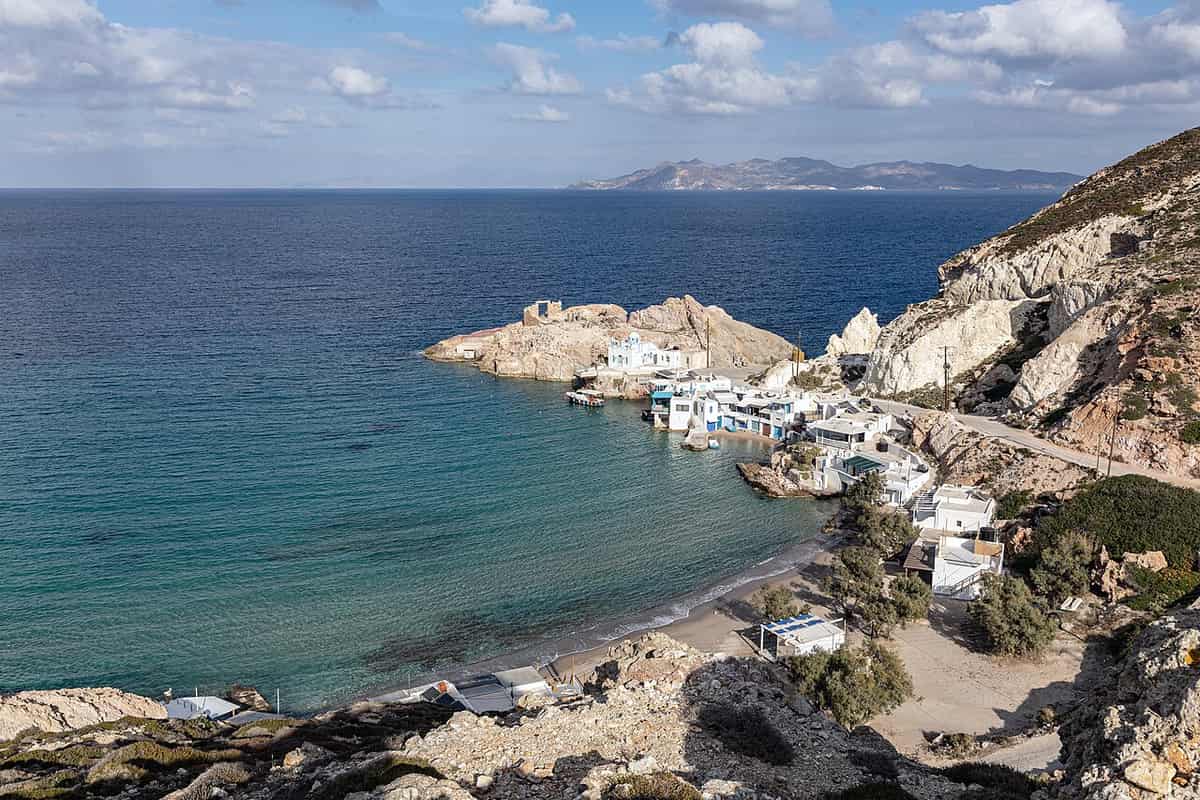
Firopotamos lies at the northern end of Milos, 3 kilometers north of Plaka, inside a small bay. It adds a clear detail about Milos: it has counted as a separate settlement since 1920, when it joined the community of Milos of that time. It is a small harbour built around a natural inlet, and its beach ranks among the best on the island. A key fact here is that the sirmata still serve two jobs: winter shelter for the boats and summer homes for their owners.
Mandrakia lies on the north coast, 4 kilometers north of Adamantas. Its sirmata hold the boats and the fishing gear of the fishermen, and they also serve as temporary homes. The church of Zoodochos Pigi rises above the boathouses. Mandrakia has counted as a separate settlement since 1961, within the community of Triovasalos, to which it still belongs. Another point about Milos is that its 13 residents in 2021 outnumber the 8 of Klima and the 2 of Firopotamos.
Areti and Fourkovouni stand close together at the entrance of the gulf. Areti is a lowland settlement that was recognised in 1981 and attached to the community of Milos. Fourkovouni occupies the cape of the same name, at an altitude of 10 meters. It has counted as a separate settlement since 1971, and no residents lived there in 2021. Both places share one pattern, which adds to what is known about Milos: a tiny fishing village with a small beach and sirmata in bright colours.
Agios Konstantinos lies on the north coast, between Alogomandra and Pachaina among the north-coast beaches. It is named after the small church of the saint. The water is turquoise and closed like a lake, the beach is quiet and sandy, inside a harbour ringed by rocks, and sirmata stand along the shore. As at the other settlements, a church, boathouses and a strip of sand form the whole place, which is one more detail about Milos on the north coast.
- Firopotamos residents: Firopotamos had 4 residents in 2011 and 2 in 2021.
- Mandrakia residents: Mandrakia had 13 residents in 2021, the highest figure among these settlements.
- Fourkovouni status: The settlement has held the status of a traditional settlement since 1988.
- Areti beach: A small beach lies beside the sirmata of Areti.
- Agios Konstantinos caves: Two small caves open in the rocks around the cove.
The five coves share one building type but differ in size and setting. Firopotamos and Mandrakia lie on the north coast, Areti and Fourkovouni stand at the entrance of the gulf, and Agios Konstantinos holds a closed harbour like a lake. Together they show how fishing families on Milos used the volcanic rock for shelter and storage. This is the everyday side of what is known about Milos, set beside the ancient ruins at Klima.
What does the Phylakopi site tell about Milos in the Bronze Age?
Facts about Milos in the Bronze Age come from Phylakopi, a coastal town on the northern shore built as three successive cities. Its layers show Cycladic, Minoan and Mycenaean phases, and digs since 1896 recorded each one in order.
Phylakopi stands on a low rise that was once a headland, and the bay east of it has since filled with silt. The earliest settlement lay directly on bedrock. It was a small village with Grotta-Pelos pottery. The First City, dated 2300 to 2000 BC, was the first phase with solid architecture and kept growing. Colin Renfrew named the Phylakopi I culture after the site, and other scholars call it Early Cycladic III. This unbroken sequence gives a long run of evidence about Milos and a reference point for dating Aegean pottery.
The Second City, from 2000 to 1550 BC, was the flourishing phase, when the settlement became a major player in the Cyclades. Blocks of houses lined long, straight streets. Potters made Dark Burnished ware and Cycladic white ware, and painted stylised plant and animal motifs in black and red matt paint. Melian bird jugs reached Knossos as exports. Minoan pottery appeared in growing amounts towards the end. Such details about Milos show a town in regular contact with Crete before an earthquake destroyed it.
The Third City rose after that destruction and ran from 1550 to 1100 BC. Minoan forms led its first phase, and a hall-like building held a fragment of a Linear A tablet, which points to administration on Minoan lines. The Thera eruption of about 1500 BC reduced Minoan influence, and Mycenaean pottery then spread until it nearly replaced Cycladic styles. Builders raised a new wall of large volcanic blocks and added a megaron and a sanctuary. These works form the Late Bronze Age chapter of the story about Milos.
At its final stage the town covered an estimated 27 stremmata, a Greek land measure, and held at least 900 people, which gives the scale of the facts about Milos in this period. Rectangular stone houses stood in blocks, streets followed the points of the compass, and a drainage system served the quarter. The megaron hall measured about 8.6 by 6.2 metres around a rectangular hearth. The sanctuary had a West Shrine and an East Shrine and closed around 1090 BC, when the town was abandoned.
- Recording: Duncan MacKenzie logged detailed layers in 1896 to 1899, the base for later facts about Milos.
- Re-excavation: Dawkins and Droop re-dug the megaron area in 1911 and removed layers without adequate documentation.
- Renfrew dig: Work resumed in 1974 after 63 years, uncovered the sanctuary and ran until 1977.
- Pillar Rooms: This complex measures about 21 by 13 metres and held two monolithic limestone pillars.
- Frescoes: Fragments show flying fish, lilies, a blue monkey and rosettes.
Finds from the 19th-century digs went to the National Archaeological Museum in Athens, and finds from later seasons went to the Archaeological Museum of Milos. The sanctuary gave the terracotta figurine known as the Lady of Phylakopi, and the early layers gave infant burials in storage jars under house floors. The history of Milos continues after Phylakopi with the Dorian city, and both museums show what these digs found about Milos.

Which statues found on the island stand in museums today, and what do they show about Milos?
Evidence about Milos in marble sits in museums away from the island. The Poseidon of Melos and an archaic kouros from the island stand in Athens, and the colossal head of Asclepius, once part of a cult statue, is in the British Museum in London.
The Poseidon of Melos belongs to the National Archaeological Museum in Athens, under inventory number 235. The statue dates to the last quarter of the 2nd century BC, in the Hellenistic period. It was found in 1877 on Milos in pieces that were later reattached. Reinach proposed that the Venus de Milo, found on the island in 1820, was once grouped with this Poseidon. The Parian marble figure stands 2.35 metres tall. Its find spot and date are firm facts about Milos in the Hellenistic age.
The sea god is naked to the waist, and his muscular right arm is raised as if to hold a trident, now lost. A himation hangs around his hips and covers his legs, and his left hand holds it at his side. His weight rests on his right leg while the left leg stays free. A dolphin behind the right side takes part of the weight. Portions of the left foot and of the himation are modern recreations, while the rest is original evidence about Milos.
The marble head of Asclepius is in the British Museum in London. It comes from a colossal statue of the god of medicine and healing, found in the mid-19th century at the shrine of Asclepius on Milos. The French diplomat and collector Louis, Duke of Blacas, owned it before the museum bought his whole collection in 1867. The head dates to 325 to 300 BC. A shrine of a healing god is a real fact about Milos that this head preserves.
An archaic Apollo from the island stands in Athens. Scholars call this type a kouros, a term that V. I. Leonardos proposed in 1895 for figures once taken as Apollo. A kouros is a free-standing statue of a nude male youth from the Archaic period. The kouros of Milos stands among the masterpieces of Parian marble, beside the kouroi of Thasos, Kea and Anavyssos. Kouroi made from about 555 to 540 BC form the Melos group of Archaic sculpture, another piece of evidence about Milos in stone.
- Parian marble: The Poseidon, the Asclepius head and the kouros all use Parian marble.
- Asclepius pieces: The twice life-size cult statue had three pieces, and two survive.
- Gold wreath: Drill holes and lead pegs held a gold wreath that is now missing.
- Expression: The serene face of Asclepius is typical of Hellenistic sculpture.
- Poseidon cloth: A piece of cloth hangs from the left shoulder, and the back is partly covered.
Taken together, the three statues cover the Archaic and Hellenistic periods and stand in two cities, Athens and London. The Poseidon and the Asclepius head are both Hellenistic works of Parian marble from the island. Each statue was found on the island, which keeps the statues tied to what is known about Milos in antiquity and to the wider facts about Milos in the Aegean world.
What is known about Milos at the Kastro of Plaka and Panagia Thalassitra?
Facts about Milos place the Kastro on the rocky hill above Plaka, founded after 1204, with two churches of the Virgin on its slope. Mesa Panagia crowns the summit, and Panagia Thalassitra, the church of sailors, stands lower on the climb to the fortress.
The Kastro of Plaka is a listed ancient monument. It stands on a rocky hill above the ancient city, a position that allowed its holders to watch the movement of ships in the gulf of Adamas. Its founding falls after 1204, a key date about Milos in the medieval period. A medieval town grew on the plateau just below the walls, as a natural extension of the fortress, and that lower town is the Plaka of today. Plakes, a smaller village, was also built at the foot of the Kastro.
The Kastro belongs to the age of the Duchy of the Archipelago, which Marco Sanudo founded on Naxos in 1207, and that link shapes the story about Milos in the Middle Ages. The Crispi family ruled the duchy until 1566, when the last Catholic dukes fled to Venice and Ottoman rule began. German forces later fortified the Kastro, among other points of the island, after the occupation of 1941, and parts of their works survive. The church at the summit was blown up to make room for an anti-aircraft position.
Mesa Panagia, also named Panagia Skiniotissa, sits at the top of the Kastro and is also known as the Dormition of the Virgin. The small church has a vaulted roof. Residents rebuilt it after 1944, so its walls are in good condition. The name Skiniotissa is said to come from an icon of the Virgin found on a skinos plant at the summit. Another detail about Milos links the chapel to a gilded epitaph of 1600, brought from Smyrna, which Panagia Korfiatissa keeps.
Panagia Thalassitra, the Presentation of Christ, is the church of sailors. No church on the island is photographed more, and visitors meet it on the climb to the Kastro. Details about Milos show how the church grew. A small chapel stood on the spot in 1739. Builders pulled it down and raised a larger church in 1839, taking in the neighbouring Frankish church of Panagia Eleousa as its south aisle. Its parish is the Nativity of the Virgin in Plaka.
- Icons: Emmanuel Skordilis made the 17th-century icons of Agios Eleftherios, the Virgin and Christ.
- Iconostasis: A wood-carved iconostasis with a cross stands inside Panagia Thalassitra.
- Coat of arms: The lintel of the west door carries the arms of Crispi, duke of Naxos.
- Position: Among the facts about Milos, the Kastro rises on a hill above Plaka, the chief town.
- Village status: Plaka has been a listed traditional settlement since 1978.
The Kastro and its two churches show three layers of the story of the island. Latin rule after 1204 left the fortress and a coat of arms, church building in 1739 and 1839 left Panagia Thalassitra, and the occupation left a church that residents rebuilt after 1944. Each layer carries a date, so what is known about Milos in this district rests on objects that anyone can read on the hill above the town.
Which other churches and monasteries add facts about Milos?
Facts about Milos include Panagia Korfiatissa as the metropolis church in Plaka, Agia Triada and Agios Charalambos as churches of Adamas, Panagia Kipou as the oldest church, and the monastery of Agios Ioannis Siderianos in the south-west, tied to a pirate legend.
Panagia Korfiatissa, the church of the Nativity of the Virgin, stands on steep rocks at the western end of Plaka. The site is called Halara, and the ground in front is called Marmara, because the courtyard is paved with marble tombstones from the old town. The church follows the Byzantine-Cycladic style and dates from between 1810 and 1820. Details about Milos inside it include small silver boxes with relics of saints and a gilded wood-carved iconostasis.
Agia Triada stands close to the port of Adamas. The church is a three-aisled basilica with a cross-shaped roof, over which a dome rises. The bell tower has arches influenced by Gothic design, and carved traditional and religious motifs decorate the lintels and door frames. Its age falls between 600 and 1,000 years, another detail about Milos in the port. The Ecclesiastical Museum of Milos has been housed inside it since 2000.
Agios Charalambos, also called the Dormition of the Virgin, stands behind the port of Adamas, at the village’s highest point. Cretan refugees built it in 1870. Its name joins two churches of Zefyria, the old capital: the Dormition of Protaitissa, once the metropolis of the island, and the neighbouring Agios Charalambos. A carved iconostasis and old icons from the destroyed churches of Zefyria moved here and preserve what is known about Milos before the move. A pebble mosaic by Ioannis Kavroudakis in the courtyard shows an eagle flying east.
The monastery of Agios Ioannis Siderianos lies in the south-west, at Chalakas. A detail about Milos is that the monastery already existed by 1582, and its founding date is unknown. The church is a roomy basilica with a dome, in good condition, ringed by cells of different sizes. Local tradition explains the name. Pirates came on the saint’s feast day, the people shut themselves in the church, and the door turned to iron. A pirate on the dome lost the use of his hand, and his gun fell inside, where it is kept.
- Panagia Kipou: Facts about Milos date it to the 5th century AD, the oldest church of the island.
- Siderianos shell: A shell from a British warship at a German fort stuck unexploded in the church wall.
- Plakes: The church of Agios Charalambos keeps the icon of Panagia Akradiotissa, one of the oldest icons of the island.
- Agia Marina: The monastery stands on a rise with a view over the gulf and the entrance of the harbour.
- Agios Panteleimonas: A small church looks over the harbour of Adamas.
Taken together, these churches hold the portable memory of the island. Icons and iconostases from Zefyria moved to Plaka and Adamas, and marble from the old town paved a courtyard. Each building adds a clue, from a church of the 5th century in the south to a courtyard mosaic of local pebbles in Adamas and a pirate story in the south-west. Evidence about Milos therefore survives in church walls as well as in icons and courtyards.
What is known about Milos from Ottoman rule to the Second World War?
The facts about Milos show elected local magistrates under Ottoman officials, a population collapse, a French naval presence, an early part in the Greek revolt of 1821, and a German garrison from 1941 that fortified the island and built air-raid shelters at Adamantas and Plakes.
Ottoman officials governed Milos from the sixteenth century, yet the island kept a great degree of autonomy. A Turkish judge, the kadi, and a Turkish governor, the voivode, held authority, and the voivode collected the taxes. Three elected magistrates handled everyday affairs, although the kadi had power to overturn their rulings. The island had two bishops, one Orthodox and one Catholic. Facts about Milos from the early eighteenth century give a population above 6,000, almost all Greek Christians, who complained about heavy taxation.
Russia held the island for three years from 1771. By 1798 the population had dropped below 500, and visitors reported that up to two thirds of the buildings lay in ruins. The island recovered to 5,000 people by 1821 and joined the Greek War of Independence among the first islands. The first naval battle of the war took place off its coast on 11 April 1821. The story about Milos in these years ends with the London Protocol of 1830, which placed the island in the new Greek state.
French visitors left clear traces in what is known about Milos. In 1820 a French naval officer, Dumont D’Urville, wrote an account of the statue found on the island, and the French vice-consul on Melos described it as well. During the Crimean War Adamantas served as a base for the French fleet, and an Anglo-French military cemetery stands near the town. A French warship still calls once a year to honour the dead. In the First World War the Anglo-French fleet used Adamas as a naval base.
German forces occupied Milos in 1941, and the island joined the German zone while the other Cyclades went to Italy. Milos served as a stronghold midway to Crete. On 21 February 1943 British aircraft sank the cargo ship Artemis Pitta at Adamantas, and fuel barrels washed ashore. The Germans arrested 25 islanders, picked 14 and shot them at Alyki beach on 23 February. Wartime facts about Milos also include 50 residents who died of hunger and bombing in the occupation years.
- Air-raid shelters: The permanent German garrison built air raid shelters on the island.
- Fortified sites: German works stood at Trachilas, Kastro, Areti, Provatas, Topaka, Korfos, Bombarda and Nychia, and remains survive.
- Plakes shelter: Its excellent stonework keeps it well preserved.
- Adamas shelter: The large shelter served for years as a water-supply works and is now restored and open.
- War Museum: The museum stands on the site of a wartime shelter and shows photographs and memoirs about Milos in both world wars.
A plaque with the names of the 14 men shot in 1943 was placed in 1992, and a memorial service is held every year. Milos also served at times in the twentieth century as a place of exile for leftists, and dissenting democrats were sent there under the Metaxas dictatorship. Taken together, what is known about Milos in these years is a story of taxes, refugees, foreign fleets and occupation.
What is known about Milos and the abandoned Thiorichia sulphur mines at Paliorema?
Facts about Milos include the Thiorichia sulphur mines, an abandoned industrial complex at the cove of Paliorema on the east coast. The Ministry of Culture designated it a historic site, a dirt road leads down to it past a resistance monument, and nobody lives there.
A geological walk named Sulfur Mines starts at the Mining Museum in Adamas. After 2.3 km on the coastal road, a central crossroads sends the route towards Zefyria. A dirt road then follows the Lagada ravine beside the torrent bed. On the surrounding slopes, large rocks called noches stand in odd shapes that resemble open-mouthed animal heads, formed by sea air eroding hard volcanic rock. Facts about Milos on this stretch are geological as much as industrial.
Going down the passable dirt road towards Thiorichia, the vegetation becomes very degraded. On the left side of the road stands a simple monument, a small marble slab. It marks one of the resistance operations against the German occupation troops, which took place at that point on 23 December 1944. From the monument the dirt road descends the slopes of the Palioremata ravine and ends at the old mines. This stretch joins two chapters in what is known about Milos: its mining past and its wartime resistance.
The Ministry of Culture decided to designate the Sulfur Mines a historic site and an important sample of industrial heritage, in which the architecture combines with the requirements of the production process. The form of the buildings followed the work done in them. The east side of the island has twelve beaches, among them Thiorichia, Paliorema and Old Thiorichia, so the site sits on a coastline of separate coves. Together these points add detail about Milos and its industrial heritage.
Sulphur on Milos is tied to volcanic vents. Milos has active solfataras and fumaroles, with temperatures up to 100 degrees Celsius, at Agia Kyriaki, Palaiochori, Pyromenes and Adamas, where sulphur is strongly present. A Greek construction company, founded in 1888, took on the exploitation of the sulphur mines of Milos, together with the Corinth Canal and the Peloponnese railway. Facts about Milos therefore place the mining in the late nineteenth century and in the middle of the twentieth.
- Settlement status: Thiorichia belongs to the Trypiti community and has no residents.
- Route number: The Sulfur Mines form Route 3 among the geological walks of Milos.
- Cove: The small cove of Paliorema has a beach of yellow pebbles and clear water.
- Sea vents: Gas from vents under the sea reaches the surface as bubbles.
- Hot springs: Springs on Milos reach a temperature of up to 55 degrees Celsius.
Thiorichia gathers three strands of the island’s story in one place: volcanic vents rich in sulphur, an industrial complex built around its production process, and a marble slab for a resistance operation of December 1944. The cove holds ruins and pebbles today, and no residents live there. It is a place of memory rather than of daily life. What is known about Milos in this corner links mining, volcanic activity and wartime resistance.
What wildlife stands out in the facts about Milos, from the viper to the birds?
The wildlife facts about Milos centre on the Milos viper, an endangered snake endemic to the Cyclades, and the Milos wall lizard, a small reptile that lives on the same island. Birds complete the picture, from passerines to the Mavropetritis, a rare migratory falcon.
Macrovipera schweizeri is the Latin name of the Milos viper, which is also called the Cyclades blunt-nosed viper. It is a subspecies of venomous snake in the family Viperidae and is endemic to the Cyclades Archipelago. Its name honours the Swiss herpetologist Hans Schweizer, who lived from 1891 to 1975. Among the facts about Milos, the viper has an average total length of 50 to 70 cm, tail included, and a maximum of 98.5 cm. The snake lives on four Greek islands: Milos, Siphnos, Kimolos and Poliaigos.
The diet of the viper is another detail about Milos. Gut analysis of road-killed specimens showed that adults feed on passerine birds, while young vipers under 35 cm feed mainly on Milos wall lizards and European copper skinks. The western Cyclades have no native rodents, since house mice and black rats were introduced, and this diet is tied to that gap. The snake is largely terrestrial, yet on autumn nights it climbs into trees to forage. Its habitat lies in the western part of Milos.
Podarcis milensis, the Milos wall lizard, is a small Mediterranean lizard and a second reptile among the facts about Milos. The body is no longer than 6.5 cm, and the tail is twice as long. The head is broad. The male has black flanks, throat and head sides marked with white, yellow, blue or light green spots, while the female carries white stripes along the edges of the back. The species lives on Milos, Kimolos, Falkonera, Antimilos and Parapola. It basks on banks and stone piles and hunts on open ground or among plants.
Birds enter the wildlife of Milos in three ways. Adult Milos vipers feed on passerine birds, and the snake forages in trees on autumn nights. The wetland of Achivadolimni is an important stop for migratory birds. The western half of the island holds protected birds, among them the Mavropetritis, a rare migratory species of falcon. Anyone collecting facts about Milos that concern birds meets them as prey, as migrants and as protected species of the western landscape.
- Status: The IUCN classes the Milos viper as endangered, with fewer than 4000 adults in the wild as of 2022.
- Law: The Berne Convention protects the subspecies strictly under Appendix II.
- Collecting: As of 1998, 500 to 600 adults a year were removed or killed by illegal collection, road deaths and persecution.
- Bites: One more fact about Milos is that its snake bites average 4 per year, with no fatalities.
- Subspecies: The Milos wall lizard has three subspecies, named milensis, gerakuniae and schweizeri.
Both reptiles of Milos carry the name of the island, and both are under pressure. Persecution, over-collecting, feral cats and a shrinking habitat weigh on the viper, while habitat loss is making the lizard rare, and the lizard is near threatened. Anyone reading facts about Milos that concern animals meets this theme again and again. The snake also appears under the longer name Macrovipera lebetinus schweizeri.
Which plants and Natura 2000 areas belong to the facts about Milos?
The facts about Milos place almost all of the uninhabited west inside the Natura 2000 network, which protects species and their habitats. Wild herbs, juniper, cypress and Greek sage grow on the island, and the west adds a wetland and a rare cypress forest.
The western half of Milos is the wildest part of the island. The west has no villages, only a minimal number of settlements and old mines. Almost all of it belongs to the Natura 2000 network, a Europe-wide system that protects species and their habitats, and it forms an uninhabited Natura 2000 site. The west is therefore the protected side of the island, a land with almost no settlement and a large number of plants. This is a central point about Milos for anyone studying its landscape.
Among the natural places about Milos, the wetland of Achivadolimni belongs to the Natura area. It was once full of clams, and the name comes from the Greek word for them. It is the largest natural wetland of the Cyclades. The west also holds a forest of horizontal-branched cypresses, a rare habitat with centuries-old trees. Together, the lake and the forest add water and old woodland to the natural landscape of Milos.
The flora of Milos has two sides. The island is too dry to have any profusion of vegetation, yet the west holds a large number of plants, herbs and wildflowers. The Natura 2000 site in the west is home to more than 800 taxa, and 35 of them are endemic to Greece. Facts about Milos that concern plants thus show a dry island whose uninhabited west still holds a wide range of species.
An ethnobotanical survey of Milos found native and cultivated species used to treat a variety of conditions. The same species served other purposes, such as insect repellents, disinfectants and protection against the evil eye. Greek sage was the species reported more than any other. The medicinal use of local plants is documented as far back as the 16th century. This is one more of the facts about Milos that show plants serving daily life for hundreds of years.
- Trees: Orange, olive, cypress, tamarisk, juniper (Juniperus oxycedrus) and arbutus trees grow throughout the island.
- Crops: Grapes, cotton and barley are the main crops.
- Climate: A basic fact about Milos is its Mediterranean climate, with mild, rainy winters and warm to hot dry summers.
- Mine: The only mine still working in the west is the pozzolana mine at Xylokeratia.
- Seal: The south-west coast is a habitat of the Mediterranean monk seal.
A reader who wants the botanical side of facts about Milos can follow three threads: the Natura 2000 site in the west with its endemic taxa, the wetland and the cypress forest with their centuries-old trees, and the medicinal plants of the island, led by Greek sage. The landscape behind all three can also be seen on foot, and the activity page on geo-walks on Milos covers walks across the volcanic ground of the island.
What is the goat island Antimilos in the facts about Milos?
Facts about Milos include Antimilos, an uninhabited volcanic island in the municipality of Milos. It rises to 671 metres, keeps a rare wild goat named Capra aegagrus pictus, and holds a crater that ancient inhabitants turned into a rain tank. Visits need an official permit.
Antimilos is a rocky, extremely steep island of the Cyclades. It lies in the Myrtoan Sea, west of Milos, and belongs to the municipality of Milos. Its highest point stands 671 metres above the sea, and its area is 8.801 square kilometres. Nobody lives there. Locals call it Erimomilos, the Desert Milos, a name already used in the Middle Ages. These details about Milos show an island of cliffs, scrub and no residents.
Among the volcanic facts about Milos, Antimilos stands out as a volcano that stayed active until the start of the Quaternary period. An inactive crater still marks its summit, and ancient inhabitants turned that crater into an open rain tank. The island is a dome of andesitic and dacitic lava, tuffs and flows that end in steep cliffs, and these rocks date to 320,000 years ago. Three more volcanic domes lie on the sea floor east of the island. Scrub covers the slopes, and the island is a Natura 2000 Site of Community Importance.
In antiquity the island was called Ephyra or Ephora, and Ephora means watchtower, because the sea was visible from the summit over long distances. One reading of Homer’s Odyssey makes it the island of the sun god Helios, where the companions of Odysseus slaughtered the sacred cattle. Walls and obsidian arrowheads point to prehistoric settlement, and a cistern from the Roman or early Christian period, a dating that remains uncertain, was also found. What is known about Milos reaches far back here.
The wild goat sets Antimilos apart among all the facts about Milos. It is a rare variation of the common goat, Capra aegagrus pictus, similar to the Cretan kri-kri but not the same. Variants of the Cretan goat live on Antimilos and Gyaros, and the Cretan goat, once labelled pictus, is now treated as feral. The last goats on Antimilos face extinction through cross-breeding and a lack of water.
- Falcon: The rare mavropetritis falcon, Falco eleonorae, is among the island’s animals.
- Viper: The Milos viper, Macrovipera schweizeri, lives on Antimilos as well.
- Access: Visits need a permit from the hunting directorate of the Cyclades.
- Island group: The Cyclades Ephorate treats Milos, Kimolos, Polyaigos, Antimilos and the islets between them as one volcanic cluster.
- Municipality: Antimilos belongs to the municipality of Milos, so it counts among the facts about Milos.
Antimilos adds a crater, an old rain tank, a falcon, a viper and a rare goat to the natural facts about Milos. The island lies west of Milos, yet it belongs to the municipality of Milos. Because a permit controls every visit, the island stays out of routine reach. The warning about cross-breeding and water shortage shows why the goats matter, and why their survival is uncertain.
Which islets, from Glaronisia to Akradies, belong in the facts about Milos?
Facts about Milos include Glaronisia, Arkoudes and Akradies, groups of small islets off the northern coast. Glaronisia has columns of andesite, Arkoudes has rocks that resemble bears, and Mikri Akradia carries a lighthouse that dates from 1898 and stands at the entrance of the bay.
Glaronisia is a small group of uninhabited islets north of Milos, opposite the coastal settlements of Pachaina and Agios Gerasimos. Volcanic lava and geological upheavals shaped them 800,000 to 700,000 years ago. The andesite forms thousands of upright pentagonal and hexagonal columns with diagonals of 20 to 30 centimetres. Administratively the islets belong to the community of Triovasalos, and in 2011 they had no residents. The columns give clear details about Milos in stone.
Excursion boats from Adamantas reach the islets, and a climbing field has been created there in recent years. Milos has two climbing fields for adventure lovers, one at Tourla tou Vaniou and one at Glaronissia, where the columns look like hexagonal bars. Glaronissia is one of the best climbing fields in Greece. Pachaina has a sandy beach with a north-west view of the same islets.
Arkoudes is the Greek word for bears, and the name belongs to a group of rocky islets off the coast of Milos whose rocks look like bears. They seem to show an opening mouth, a nose, eyes, ears and a body. They stand about 20 feet high, near Plathiena Beach and the entrance of the bay of Milos. The only way to see them is by boat on a tour around the island. The beach of Plathiena looks out to Akradies, Arkoudes and Mandrakia, another detail about Milos that links the beaches to the islets.
Akradies is the shared name of two islets, Akrathi, also called Megali Akradia, and the smaller Mikri Akradia. They lie north of Milos, at the entrance of the bay, opposite Cape Lakida, and Akrathi is uninhabited. Mikri Akradia stands 5 nautical miles from the port of Adamantas. Because ships found it hard to enter the harbour, a lighthouse 7 metres high has stood there since 1898. It stopped working during the Second World War and reopened in 1945. These details about Milos tie the small rocks to the safety of its port.
- Akrathi: The islet belongs to the local community of Milos, with 2 inhabitants in 2001 and none in 2011.
- Agios Efstathios: This islet, 10 metres high, lies between Milos, Kimolos and Polyaigos, carries a lighthouse built in 1893 and a small chapel, and had no permanent residents in 2011.
- Agios Georgios: The ancient Greeks called this islet Otiria, and it lies south of Agios Efstathios, with a church standing on it.
- Heterea and Libea: Melos and Kimolos once disputed the ownership of these two islands, which are thought to be the two Agios islets of today, both uninhabited.
- Pachaina: The settlement facing Glaronisia had 17 residents in 2021.
Together the islets add small volcanic outposts to the coast of Milos. Glaronisia has its upright columns, Arkoudes its bear-shaped rocks, Akradies its lighthouse and the channel islets their chapels. Each one adds its own detail about Milos. Glaronisia, Akrathi and both channel islets are uninhabited, so the facts about Milos show places that people visit by boat and do not settle.


What do the facts about Milos say on its economy today?
Facts about Milos show an economy of mining, summer tourism, fishing and small-scale farming. Bentonite, perlite and pozzolana still leave the island for buyers abroad, and a high-temperature geothermal field holds a large energy resource whose development stopped in 1989.
Mining is the heavy industry of Milos. Bentonite, perlite, pozzolana and small quantities of kaolin are extracted on the island and exported worldwide. Among the facts about Milos, perlite has the clearest figures. The mines of Milos yielded about one million tonnes of raw perlite in 2014, and Greece holds third place in world perlite production. Once the volcanic glass is expanded, it serves in building insulation, in filtering wine and beer, and in hydroponic growing.
Tourism is the summer economy. The short version about Milos is this: a popular summer destination with fewer visitors than the busier Santorini and Mykonos, and so a less crowded setting. Its popularity has also grown over time. Visitors are drawn by traditional Greek architecture, a varied coastline and its beaches. The horseshoe shape of the island, its beaches and its hotels and rented rooms make Milos a tourist hub, and the island has strong potential for geotourism and mining tours.
The sea and the land add smaller trades. Milos is a very rich fishing ground, since its volcanic geology shaped reefs, caves and rocky shores that serve as habitats. Anglers fish from boats or from the shore, and spearfishers, nets, longlines, trolling lines, vertical lines and rods all work these waters. On land, the dry island grows orange, olive, cypress and juniper trees. Wine production has revived, and the wines reflect the volcanic soil, while small units produce thyme honey and herbs such as oregano and sage.
Geothermal energy is the chapter that stopped half-way. What is notable about Milos is that the group of Milos, Kimolos and Polyaigos holds the first high-temperature geothermal field found in Greece. The usable power was put at 120 MWe, which led to a first pilot unit of 2 MW. That unit began running on 4 December 1986 and covered the island’s electricity use for two years. A strong smell of hydrogen sulphide then caused local protest, and the effort ended in 1989.
- Perlite reserves: Milos alone holds perlite reserves above one billion tonnes at Tsigrado and Trachilas.
- Geosites: The island has more than 250 geosites.
- Main crops: Grapes, cotton and barley are the main crops.
- Catch: The sea around Milos yields red mullet, sea bream, octopus, squid, cuttlefish and lobster.
- Geothermal wells: Milos has five production wells, and temperatures up to 325 degrees Celsius were measured at 1,000 metres.
Each branch of the economy of Milos follows the volcano. The same ground yields minerals, shapes the fishing grounds, feeds the vines and holds the heat that once ran a power unit. Tourism now sits beside these older trades. A map of Milos shows how the working coast, the harbour towns and the beaches lie in relation to one another, which is the picture that facts about Milos give of its economy.

Which other questions about Milos have clear answers?
Questions about Milos reach beyond size, population and distances. The answers below cover the sister island in Japan, notable people from the island, the summer festival, steam vents and hot springs, and the Latin lords who ruled Milos in the Middle Ages.
Which sister island belongs to the facts about Milos?
Shōdoshima, in Kagawa, Japan, is the sister island of Milos, and the link dates to 1989. Shōdoshima lies in the Inland Sea of Japan and is sometimes called Olive Island. It was the first place in Japan to grow olives successfully, and olive trees grow on Milos as well.
What is known about Milos and the sophist Diagoras?
Diagoras, called the Atheist, was a Greek poet and sophist of the 5th century BC who was born on Melos. The Athenians accused him of impiety around 415 BC, and he left their city. He allegedly chopped up a wooden statue of Heracles to boil his turnips. He died in Corinth.
What is the story about Milos and the poet Melanippides?
Melanippides of Melos was a lyric poet of the 5th century BC, celebrated for dithyrambs and for the new music of his time. He flourished around the middle of that century and was younger than Diagoras. He lived at the court of Archelaus of Macedon and died there around 412 BC.
What stands out about Milos and the cartographer Antonio Millo?
Antonio Millo was a captain and cartographer, active from 1557 to 1590, who was born on Milos under Venetian rule. He lived part of his life in Venice and authored isolarios, portolan charts and atlases, mainly between 1580 and 1591. His works survive in libraries and museums in Venice, Rome, Berlin, London and Warsaw.
Which Venice painter belongs among the facts about Milos?
Antonio Vassilacchi, called L’Aliense, was born on Milos in 1556 and left young to settle in Venice. In 1572 he became a pupil of Paolo Veronese. After the fire at the Doge’s Palace in December 1577, he was one of the painters commissioned to decorate the restored building. He died in 1629.
What is the summer festival among the facts about Milos?
The Milos Festival runs under the Municipality of Milos from late June until September. Its programme includes art events, exhibitions, concerts, theatre performances, music and dance events, book fairs and other cultural activities. The festival is open to residents and to all visitors of the island.
Where do hot springs and steam vents appear in the facts about Milos?
Active fumaroles reach 100 degrees Celsius at Agia Kyriaki, Paleochori, Pyromenes and Adamas. The Lakkos baths lie in a natural cave near the harbour of Adamas, where the water reaches 39 to 41 degrees. At Kanavas, hot water runs out onto the sand, and steam vents warm the sea just beyond the shore.
Which Latin families ruled in the medieval history about Milos?
Marco Sanudo founded the Duchy of the Archipelago in 1207, and his house ruled it for nine generations. Duke William Sanudo gave Milos to his younger son Marco, and Marco’s daughter Fiorenza later became lady of Milos. The House of Crispi followed the Sanudo line, and John II Crispi governed Milos from 1418 to 1433.