Once you rent a car, an ATV or a buggy from Rac SA, take the road to Fyropotamos.
Fyropotamos is another traditional settlement in the north of Milos, built on a cape. It has only a few boathouses (sirmata), and for many years it was used as a port for shipping minerals; a ruined stairway and an old processing plant for the island’s rich ore still stand there.
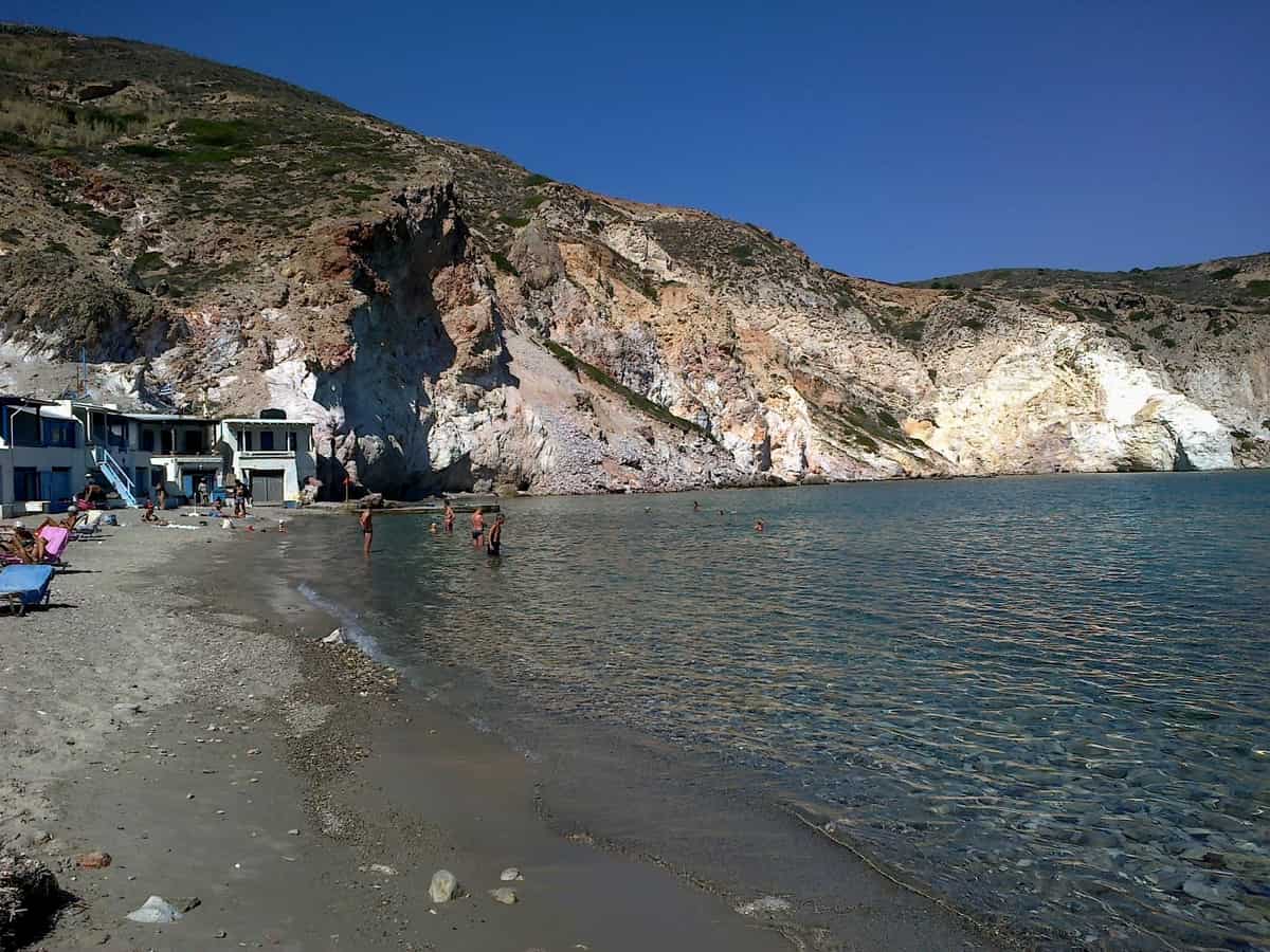
Fyropotamos has a beach with all the essentials. The village lies on a narrow strip of land by the sea, framed by striking, colourful formations of volcanic rock.
Fyropotamos is even more striking at sunset, so we suggest you make one of your visits to the village in the late afternoon.
Fyropotamos is a small fishing settlement on the north coast of the island of Milos, in the Cyclades. It sits in a small bay, 3 km north of Plaka, and its beach, boathouses and old loading ladder share one short stretch of shore. This page sets out the facts about Fyropotamos, from its position and name to the mining past of the island.
Milos is a volcanic island in the Aegean Sea, just north of the Sea of Crete, and Fyropotamos sits at its northern tip. The island has two extinct volcanoes and a long history of mining. The first sections place Fyropotamos on the island, trace the spelling of its name and link its shore to the mineral trade of Milos.
Where is Fyropotamos on Milos and how is the settlement laid out?
Fyropotamos lies at the northern tip of Milos, 3 km north of Plaka, in a small bay. The settlement is a small harbour around a natural cove, with a creek ringed by boathouses, a sandy beach, tamarisk trees and an abandoned loading ladder at its far edge.
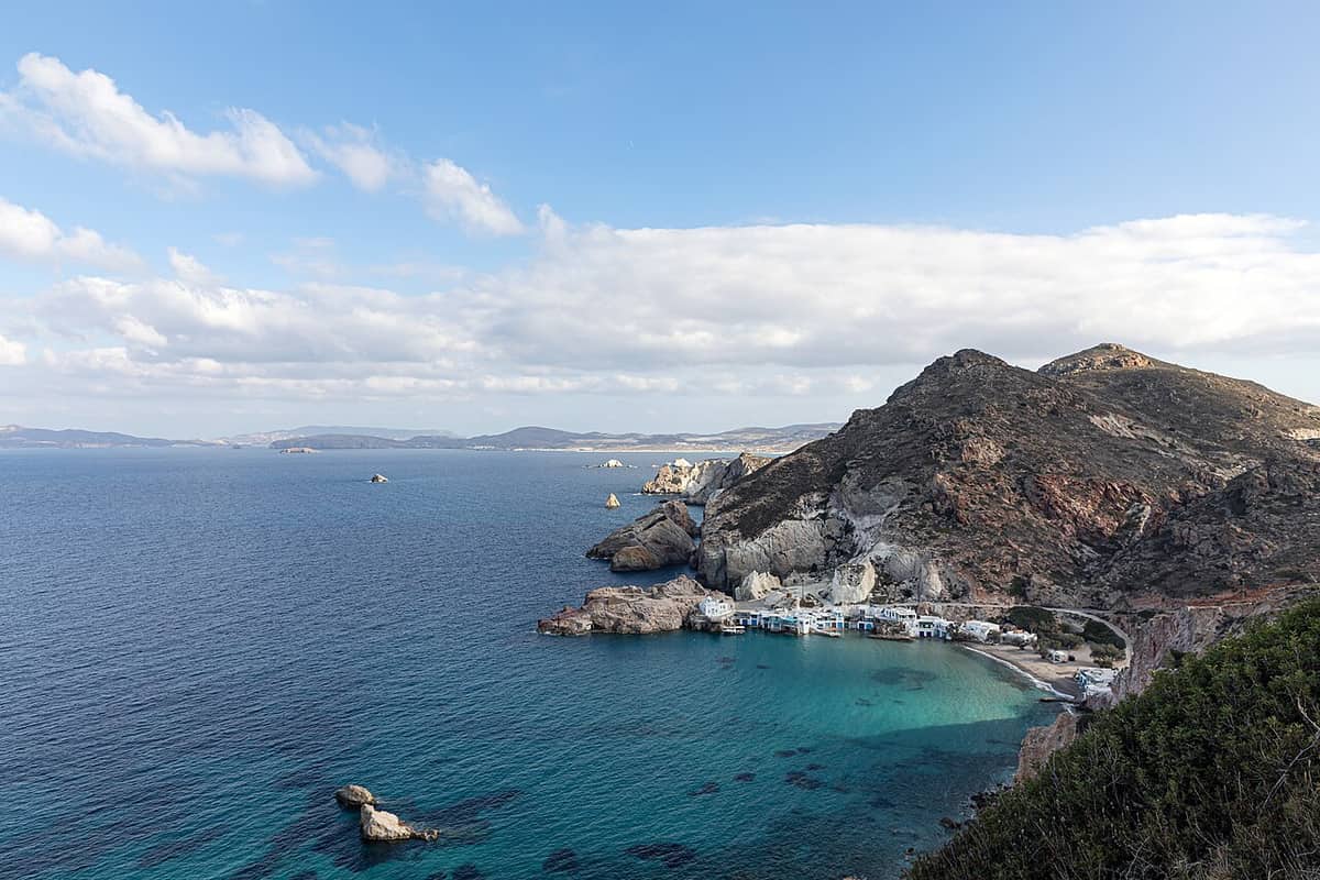
Milos is the Cyclades island farthest to the south-west. It measures about 23 km from east to west and 13 km from north to south. The island capital, Plaka, stands on a plateau above the harbour town of Adamantas, with the Kastro on a hill above it. Fyropotamos lies 3 km north of Plaka, where the land meets the north shore. It is a fishing village at the northern tip of the island.
The north side of Milos has 16 beaches, and the row from west to east begins with Plathiena, Trachilas, Fyropotamos, Tourkothalassa, Sykia, Mandrakia and Sarakiniko. Fyropotamos therefore comes third in that row, beside the Trachilas shore. The Trachilas volcano, to the north-north-west, is one of two extinct volcanoes of Milos, the other being Fyriplaka. Volcanic activity on the island began 2 to 3 million years ago and last erupted 90,000 years ago.
The settlement itself is compact. A small harbour wraps around a natural cove, and the creek is ringed by the boathouses that Milos calls sirmata. Sirmata are boat shelters dug into volcanic tuff beside the sea, found mainly at Klima, Mandrakia and Fyropotamos. Tamarisk trees grow in the settlement, and the sandy beach has a beach bar. The beach is small but organised, and it suits swimming and fishing.
Past the last fishing houses, an abandoned loading ladder and the church of Agios Nikolaos stand at the edge of the settlement. In 2001 Fyropotamos ranked among the inhabited settlements of Milos, beside Adamas, Triovasalos and Pollonia. It belongs with Klima and Mandrakia among the smaller settlements of the island, each set beside the sea.
- Position: Fyropotamos lies 3 km north of Plaka, the capital of Milos.
- Water: The settlement is a small harbour built around a natural cove with a creek.
- Shore: Fyropotamos has tamarisk trees, a sandy beach and a beach bar.
- Order: Along the north coast, Fyropotamos follows Plathiena and Trachilas from the west.
- Edge: The abandoned loading ladder stands past the last fishing houses.
In short, Fyropotamos is a compact place. One cove, one creek, one beach and one row of boathouses fill the shore, while the ladder and the church mark the far end. The settlement belongs to the fishing villages of Milos, and its layout shows how a whole village fits into a single bay, with every part set beside the water.
What do the name Fyropotamos and its loading ladder say about the mining past of Milos?
Fyropotamos carries the Greek name Φυροπόταμος, also spelled Firopotamos in English. Its abandoned loading ladder points to the shore trade of an island whose bentonite, perlite and pozzolana are sold worldwide, and whose sulfur, alum and obsidian made Milos known in antiquity.
The Greek form of the name is Φυροπόταμος. In English the place appears as both Fyropotamos and Firopotamos, and this page uses the first spelling. Fyropotamos was already a separate settlement in 1920, when it was attached to the community of Milos of that time. Its Greek description is a seaside settlement, that is, a settlement that stands directly on the shore.
The mining story of Milos is far older than the settlement. Obsidian from Milos was a commodity as early as 15,000 years ago, and it was traded over long distances and fashioned into extremely sharp stone tools well before farming began. The obsidian comes from two hills of eastern Milos, Nychia and Demenegaki. Roman-period coastal sites at Agia Kyriaki and Paliochori show where earth was worked and the mineral product was enriched in dedicated areas, beside storage rooms, living quarters and ceramic workshops.
Ancient writers valued the earths of Milos. Pliny the Elder wrote that Milos held more sulfur than any other place in the ancient world, and in ancient times the alum of Milos ranked next to the alum of Egypt. The Melian earth, a substance made mainly of kaolin, gave artists a white pigment, and the painter Apelles used it as one of his four basic colours.
The shore trade of Milos began long before any ladder. Those in search of obsidian arrived by boat, beached it in a suitable cove and cut pieces of the volcanic glass from the quarries. At Fyropotamos, an abandoned loading ladder stands past the fishing houses. A loading ladder implies cargo from the shore, and bentonite, perlite, pozzolana and small quantities of kaolin are mined on Milos and sold all over the world. The ladder is abandoned today, and it links the shore of Fyropotamos to the trade of the island as a whole, without pointing to any single mineral.
- Sulfur: Sulfur mining on Milos ended in the middle of the 20th century.
- Millstones: Millstones were extracted on the island until the early 20th century.
- Barite: Barite mining on Milos continued until 2000.
- Bentonite: Bentonite has been found in Greece at a deposit on the volcanic island of Milos in the Aegean Sea.
- Museum: The Mining Museum of Milos, created in 1998, shows the minerals mined there from the Neolithic era onward.
Fyropotamos therefore sits inside a long story of extraction on Milos. The name of the settlement is Greek, and its shore holds a ladder from a working past, while the mining history comes from pits and coasts across the whole island. The ladder at Fyropotamos remains a visible sign of that trade in the settlement, and the rest of that story belongs to the island as a whole.
Where does the church of Agios Nikolaos stand at Fyropotamos?
Fyropotamos keeps its church of Agios Nikolaos at the edge of the settlement, beyond the fishing houses. The abandoned loading ladder stands at the same edge. The dedication to Saint Nicholas, the patron saint of sailors and travellers, suits a fishing settlement.
Fyropotamos reads in a fixed order from the creek to the edge. First come the tamarisk trees and the creek surrounded by wires, then the sandy beach with its beach bar. The last stretch reaches the edge of the settlement. After the fishing houses stand the abandoned loading ladder and the church of Agios Nikolaos. The church therefore lies beyond the fishing houses, at the edge of Fyropotamos, at the same edge as the loading ladder.
Saint Nicholas is the saint behind the name. Tradition dates his life from 15 March 270 to 6 December 343. He was an early Christian bishop of Greek descent from the maritime city of Patara in Anatolia, who became Bishop of Myra. A story about a storm at sea shaped his role. A ship he travelled on was nearly destroyed, but he rebuked the waves and the storm subsided. Tradition therefore venerates him as the patron saint of sailors and travellers, so the dedication matches the work of the fishermen at Fyropotamos.
Greek tradition adds more. Among Greeks and Italians, Saint Nicholas is a favourite of sailors, fishermen, ships and sailing. Greek folklore called him the Lord of the Sea, and modern Greek scholars see that figure as a kind of Christianised version of Poseidon. He is also the patron saint of all of Greece, of the Hellenic Navy in particular, and of cities that maintain harbours. His feast day is 6 December, the day when his death is commemorated.
Milos has more than one place called Agios Nikolaos, so the name needs care. Churches named Agios Nikolaos also belong to the parish of Agios Charalambos in Plakes and to the parish of Agios Nikolaos in Tripiti. A beach named Agios Nikolaos is one of the 25 beaches inside the gulf. The church at Fyropotamos is a separate building on the north coast, at the edge of the settlement.
- Position: The church stands at the edge of the settlement, beyond the fishing houses.
- Ladder: The abandoned loading ladder stands at the same edge.
- Origin: Saint Nicholas came from the seaport of Patara and served as bishop of Myra.
- Folklore: Greek folklore called the saint the Lord of the Sea.
- Feast: The saint is commemorated on 6 December.
The church of Agios Nikolaos gives Fyropotamos a fixed point at the edge of the settlement, beyond the boathouses, where the loading ladder also stands. Its dedication matches the work of the place, since Saint Nicholas is the patron saint of sailors and fishermen. At Mandrakia, further east along the north coast, the church of Zoodochos Pigi stands above the boathouses instead, so each settlement places its church differently.
How do the sirmata of Fyropotamos work as boathouses?
Fyropotamos has sirmata, small boathouses dug into soft volcanic rock beside the sea. They first protected fishing boats in winter and in bad weather, then became fishermen’s houses. Today the owners use them as summer homes, and the boats go inside for the winter.
The local word appears as Syrmata in English and as σύρματα in Greek. It translates as wires, and the creek of Fyropotamos is surrounded by them. The name goes back to the fishermen, who dragged the boats out of the shelter where they spent the winter and back into the sea. Fyropotamos is one of the settlements that have sirmata, together with Klima and Mandrakia. Each spelling refers to the same building, a boat house beside the sea. This page uses sirmata for every spelling, and boathouses for the buildings themselves.
The rock explains the buildings. Milos is of volcanic origin, with tuff, trachyte and obsidian among its ordinary rocks. The sirmata are rock-cut seaside houses, painted in colour and a characteristic feature of Cycladic architecture. The traditional settlements of Milos stand in small coves, with houses dug into soft rock or into natural cavities of the rocks. The creek of Fyropotamos follows this pattern.
The use of the sirmata changed over time. They first protected the boats of fishermen in winter and in bad weather, and later turned into fishermen’s houses and into summer accommodation. At Fyropotamos today, the boats stay in the small houses during the winter period, and in summer the owners use the same houses as summer residences. One building therefore serves two seasons, with the boat inside in one season and the family in the other.
Fyropotamos is one of the seven main traditional settlements of Milos: Klima, Mandrakia, Fyropotamos, Areti, Agios Konstantinos, Fourkovouni and Empourios. They are small fishing ports with a rare island architecture. On neighbouring Kimolos, which lies near the bigger island of Milos, syrmata are caves carved into the soft rocks and sealed with colourful wooden doors, so the same building type appears on both islands, each time cut into the soft rock beside the water.
- Setting: The creek of Fyropotamos is surrounded by sirmata.
- Colour: The sirmata are cave dwellings by the sea, painted in bright colours.
- Doors: The sirmata of neighbouring Kimolos are sealed with colourful wooden doors.
- Winter: The boats of Fyropotamos are kept inside the sirmata during the winter period.
- Summer: The owners use the sirmata as summer homes.
The boathouses give Fyropotamos its working character. The creek holds the sirmata, the sirmata hold the boats in winter, and the owners return to them in summer. The sirmata of Fyropotamos are famous, and together with the loading ladder and the church of Agios Nikolaos they tie the place to boats and to the fishing past.
What is the beach at Fyropotamos like, and how does the north wind reach it?
Fyropotamos has a small, organised, sandy beach inside a natural cove at the north end of Milos. Tamarisk trees grow in the settlement and a beach bar serves the sand. The meltemi, a strong north wind of the Aegean, is the weather to watch.
The beach at Fyropotamos is small, organised and sandy, with a beach bar. The settlement is a small harbour built around a natural cove, and the wires, the boat shelters of the fishermen, surround that cove. The sand therefore lies inside a small fishing harbour, so the beach and the boat houses share one small cove.
The rock around the beach at Fyropotamos is volcanic. The north of Milos was formed from a series of volcanic layers, and the extinct volcano Trachilas stands in the north-north-west. Milos has more than 75 beaches, with crystal clear blue waters and colourful sculpted rocks, and the rocks that enclose each beach make it differ from the next.
Shelter at Fyropotamos comes from the cove and the rock. Fishermen on Milos kept boats in the wires to protect them from winter weather, and dragged them back to the water when needed. Tuff is a relatively soft rock, so builders have used it for construction since ancient times. Fyropotamos is one of the settlements where the wires are cut into volcanic tuff, so the shelter is carved into the shore itself.
Wind decides how the cove feels. The meltemi is a strong, dry north wind of the Aegean, and in the southern Aegean it blows from the north-west. The islet of Kara lies east of the bay of Fyropotamos, in the southern Aegean. Fyropotamos, at the northern tip of Milos, therefore lies on the side the wind comes from, and the sea in front of the sand follows the weather. The same wind can give leisure sailors a good, steady breeze for sailing.
- Season: The meltemi blows from late spring until mid-September.
- Afternoon: The wind is at its strongest in the afternoon.
- Night: The wind can die down at night, though a spell can run for days without a break.
- Force: It can blow at force 7 to 8 on the Beaufort scale and comes up in clear weather without warning.
- Heat: The north wind tempers the fierce summer heat of the region.
A day at Fyropotamos starts with two checks. The first is the beach itself, which is sandy and organised, with tamarisk trees and a beach bar. The second is the wind, which blows across the whole Aegean from late spring until mid-September. Other shores of the north coast are compared with Fyropotamos on the page about the beaches of Milos.

How do swimming and snorkelling work along the rocks and old harbour works at Fyropotamos?
Fyropotamos suits swimming and fishing. Snorkelling needs only basic swimming, so a swimmer with a mask and a snorkel can study the rocks, the boat houses and the abandoned loading ladder at the edge of the settlement from the surface.
Fishing and swimming share the water at Fyropotamos. The beach is suitable for both, and Milos is a very rich fishing place because of its volcanic geology. Fyropotamos is a fishing village with a small harbour, and the wires beside the sea still hold boats in winter. The cove at Fyropotamos is therefore a harbour as well as a beach, and its water serves the boats and the swimmers.
Snorkelling means swimming face-down in the water while breathing air through a shaped tube called a snorkel. A snorkeller treats a shallow reef with care. Enough water must lie over the top to swim across without kicking the bottom, and an isolated shallow structure can be approached from the sides. At Fyropotamos the wires stand beside the sea, and an old loading ladder stands at the edge of the settlement. The same rule fits any rock or old structure in shallow water there. A wetsuit also gives buoyancy and protection from abrasion, ultraviolet exposure and stings from marine organisms.
The old harbour works at Fyropotamos centre on the loading ladder. The abandoned loading ladder stands after the fishing houses, at the edge of the settlement, beside the church of Agios Nikolaos. The harbour is built around the cove, and Milos has a rare, wild beauty even at its bottom. A snorkeller at Fyropotamos can look at the shore structures from the water.
Snorkellers at Fyropotamos face a plain risk from the sun. The back, the ankles and the rear of the thighs stay exposed to the sun for long periods and can burn badly even when slightly submerged. Dehydration is another concern, and hyperventilating before submerging can lead to shallow water blackout. A slow, relaxed surface breathing style keeps the work of breathing low and the carbon dioxide level down.
- Blast clearing: A sharp exhalation on return to the surface expels water from a plain snorkel.
- Displacement: Tilting the head back shortly before surfacing and exhaling fills the tube with air.
- Rash guard: It protects the wearer against abrasion and against sunburn.
- Sunscreen: Waterproof sunscreen lotions can be environmentally damaging.
- Marine life: At Fyropotamos the etiquette for marine life is to observe and not touch.
Swimming at Fyropotamos is a plain matter of sand, a cove and a north wind to check. Snorkelling adds the rock, the wires and the old loading ladder along the shore, with the sun and the breathing rules as the cautions. It lets a swimmer observe underwater life in a natural setting without the complicated equipment and training that scuba diving needs. The beach at Fyropotamos is small, organised and sandy, and the wind sets the rhythm of the sea along the whole north coast of Milos.

How do visitors reach Fyropotamos, and what lies on the way?
Fyropotamos lies 3 km north of Plaka, the capital of Milos, which the road from the port of Adamantas reaches after a climb to the plateau and a pass through Triovasalos. Mandrakia and Sarakiniko stand on the same north coast, with distances from Plaka and Adamantas.
Adamantas is the main port of Milos and the first stop on the way. It is the cultural and commercial centre of the island, stands on the north-east shore of the gulf, and counted 1,268 residents in 2021. A direct ferry runs from Piraeus, while other ferries call at Kythnos, Serifos and Sifnos first. From the harbour there is an ascent to the plateau above, where the capital stands, and the trip to Fyropotamos continues farther north from that plateau.
Triovasalos is the next village on the climb toward Plaka and Fyropotamos. It comes after the port and before Plaka, and it is a dense village built like an amphitheatre. Triovasalos and its twin, Pera Triovasalos, stand at 143 meters above sea level and form the daily commercial core of Milos. Saint Spyridon dates to the early 19th century. Saint George, in Pera Triovasalos, dates to 1849 and has a marble iconostasis.
Plaka, the capital of Milos, stands 220 meters above sea level, looks over the gulf, and counted 902 residents in 2021. Fyropotamos lies 3 km north of it. The official name of Plaka is Milos, a change dated to 1912, and the name Plaka comes from the flat ground where houses rose once the castle no longer had room for the whole population. A longer account of the town is on the page about the village of Plaka.
Two more places lie on the same north coast as Fyropotamos. Mandrakia stands 4 km north of Adamantas and belongs to the community of Triovasalos. Sarakiniko lies about 5 km from Plaka. It has bare white volcanic rock and caves cut by the waves, where Saracen pirates found shelter and gave the beach its name. Visitors scratched names into the rock, and the municipality set a fine in 2015 for polluting the area.
- Airport: The island airport lies about 4 km from the port of Adamantas, with no bus line between the two.
- Marina: Boats can moor at the marina of Adamantas or at Pollonia.
- Island size: Milos measures 23 km from east to west and 13 km from north to south.
- Sarakiniko shore: The sandy beach measures 10 meters, is unorganised, and keeps ship bollards carved into the rock.
- Sarakiniko wreck: The ship Africa ran aground there in 2003, and the wreck shows when waves retreat.
Fyropotamos therefore sits at the end of a chain of reference points: the port at Adamantas, the plateau villages of Triovasalos and Plaka, and the final 3 km north. Mandrakia and Sarakiniko lie along the same north coast, each tied to Plaka or Adamantas by a distance in kilometres. Adamantas serves as the port, Triovasalos as the commercial core and Plaka as the capital, while Fyropotamos counted 2 residents in 2021.

What do visitors ask about Fyropotamos and its surroundings?
Fyropotamos raises six practical questions about museums, cars in Plaka, buses and taxis, the rock of Sarakiniko, the port of Adamantas and the castle of Plaka. Each answer covers a place on the road to Fyropotamos or beside it on the north coast.
Which museums lie near Fyropotamos?
Plaka, 3 km from Fyropotamos, holds the archaeological museum of Milos, housed in a neoclassical building by Ernst Ziller, and the folklore museum behind the church of Panagia Korfiatissa. Adamantas holds the Mining Museum, created in 1998, the Maritime Museum, with rare maps, and the Ecclesiastical Museum, which stands near the harbour at the church of the Holy Trinity.
Can cars enter Plaka on the way to Fyropotamos?
No cars can enter Plaka, because the spaces between walls and buildings are narrow. Motorbikes, mopeds and similar vehicles are the only usable ones inside the village. The ban applies to Plaka itself, while Fyropotamos is a separate settlement, 3 km to the north, in a small bay.
Do buses or taxis serve Fyropotamos?
Town buses serve parts of Milos, and routes are fairly frequent in the summer months. Tickets are bought on board. Milos has 15 taxis, found at the port and at the airport. Sarakiniko, on the same north coast as Fyropotamos, is easy to reach by car and by bus.
What is the rock at Sarakiniko near Fyropotamos?
The Sarakiniko formation is made of sandstone layers with pumice breccias and siltstones that hold fossils, and it is about 50 meters thick. Waves appear to have laid down the volcanic material from 1.85 million years ago, and the formation first lay under the sea. Fossils of bivalves, gastropods, barnacles and sea urchins have been found in the area.
What stands in Adamantas, the port for Fyropotamos?
Adamantas holds a French cemetery from the years of the Crimean war and the 600-year-old church of the Holy Trinity. Traces of ancient buildings lie at a depth of about 30 meters off the beach, from a settlement that sank when the ground subsided, and a closed thermal spring stands at the foot of the hill.
Which castle stands in Plaka near Fyropotamos?
The Kastro of Plaka was built by the Venetians in the 13th century, on a rocky hill of volcanic origin at the highest point of the village. Its founding is placed after 1204, and the hill let it watch ship movements in the gulf of Adamantas. The castle is classed as an ancient monument, topped by a church.