Each fishing village of Milos is defined by one building, the syrma: a boathouse cut into soft volcanic rock beside the sea. These settlements are small fishing ports, built in coves and set into the natural cavities of the rock. This page explains how a syrma works and where the villages lie across the island of Milos, from the gulf to the north coast.
Milos has seven main traditional settlements, and all of them are small fishing ports. Klima, Mandrakia and Fyropotamos are the main places of the syrmata, and three smaller coves keep the same boathouses. Every fishing village of Milos is small, so the sections below read the settlements one by one. The wider overview of Milos places them beside the towns and beaches of the island.
What is a syrma, and how is a fishing village of Milos built around it?
A fishing village of Milos is built from syrmata: small two-storey houses cut into volcanic rock at the water edge. The boat stays on the ground floor in winter, the family of the fisherman lives above, and the doors and windows carry bright paint.
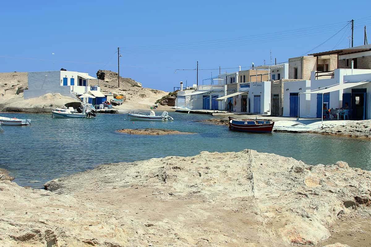
The syrmata of Milos are places where small boats are kept, dug into volcanic tuff next to the sea. Klima, Mandrakia and Fyropotamos are the main settlements that hold them. The syrmata are also small dug-in seaside houses, coloured and carved into the volcanic rock. In a fishing village of Milos the syrma is therefore the basic unit: a cavity in the rock that shelters a boat and, on the floor above, a family.
The setting is a small cove. The houses stand dug into soft rock or into the natural cavities of the rocks, and their island architecture is rare. The syrmata are cave dwellings by the sea, painted in bright colours. They first protected the boats of the fishermen in winter and in bad weather. Later they became homes for the fishermen and summer accommodation, so a fishing village of Milos holds both a harbour and homes.
The Klima houses are two-store buildings: the ground floor stores the boat during winter, and the first floor is the living space of the family of the fisherman. The two-storey houses sit in the natural cavities of the rocks, with the boats at ground level. Their doors and windows are painted, and the colours of those frames are playful in a fishing village of Milos such as Klima.
The name explains how the boathouse works. The word comes from the movement of the fishermen, who dragged the boats out of the inner space, where the boats waited out the winter weather, whenever they wanted to put them on the sea again. The syrma therefore sits right beside the water. The boat stays inside the rock through the cold months and leaves it only when the fisherman drags it out to the sea, so each fishing village of Milos stores its boats where it launches them.
- Rock: Tuff, trachyte and obsidian are among the rocks of Milos.
- Meaning: The word syrmata means wires.
- Style: The syrmata are a characteristic feature of Cycladic architecture.
- Settlements: Milos has seven main traditional settlements, all small fishing ports.
- Today: A number of the Klima houses now work as tourist accommodation.
One plan therefore runs through every fishing village of Milos: a cavity in the rock at the water, a boat below, a family above and bright paint on the frames. Eating places also work in Klima beside the tourist accommodation, so the village now serves visitors as well as fishermen. The next section places each fishing village of Milos on the map of the island.
Where does each fishing village of Milos lie on the island?
Each fishing village of Milos lies on the shore. Klima, Areti, Fourkovouni and Empourios lie inside the gulf, while Fyropotamos, Mandrakia and Agios Konstantinos lie on the north side. These seven are the main traditional settlements of the island.
Milos has 90 beaches, and they divide by side of the island. Twenty-five lie inside the gulf and 17 on the north side, and the fishing villages fall into those two groups. The north beaches run from west to east and take in Fyropotamos, Mandrakia and Agios Konstantinos in that order. The gulf beaches take in Empourios, Skinopi, Adamas, Fourkovouni, Areti and Klima. The two groups give each fishing village of Milos a side of the island.
Klima, a fishing village of Milos, stands at the entrance of the gulf, below the village of Tripiti, 6 km from Adamantas, the main port. The ancient town of Milos occupied the slope between Trypiti and the landing-place at Klima, and the village lies near the ancient theatre and near the spot where the Venus de Milo was found. These places tie Klima to the old town of Milos.
Areti, Fourkovouni and Skinopi lie at the same entrance of the gulf. Areti sits on the east side of the large gulf entrance, close to Fourkovouni, which stands on the cape of the same name. Skinopi lies by the sea entrance too, and it is both a settlement and a beach. A fishing village of Milos such as Areti or Fourkovouni is tiny, with a small beach and colourful syrmata. Empourios, near the beaches of Fatourena and Rivari, lies inside the gulf and is an old commercial port.
Fyropotamos, a fishing village of Milos at the northern end of the island, lies in a small bay, and a creek there is surrounded by syrmata. Mandrakia, a traditional fishing village surrounded by colourful syrmata, comes later along the north coast, and the Pikropigi spring is among the thermal springs there. Agios Konstantinos, named after the church of the saint, comes after Mytakas and Alogomandra, so it lies farthest east of the three. All three have syrmata, and the water at Agios Konstantinos is turquoise and closed like a lake.
- Spelling: Firopotamos and Fyropotamos are two spellings of one fishing village of Milos.
- Skinopi: The settlement and beach lie at the sea entrance to the gulf, 3 km west of Adamantas, and counted 2 residents in 2011 and none in 2021.
- Areti: The settlement lies 7.5 km north-west of Plaka.
- Fourkovouni: The settlement lies 8 km north-west of Adamantas.
- Empourios: The old commercial port has a beach, rooms for rent and a traditional tavern.
The map therefore shows a pattern. Each fishing village of Milos stands in a small cove with a strip of beach and a row of syrmata, and the coves split between the gulf and the north coast. Klima, Mandrakia and Fyropotamos are the main places of the syrmata, and Areti, Fourkovouni and Agios Konstantinos keep boathouses of their own. A fishing village of Milos belongs to one side or the other.


How do fishing and the sea shape life in a fishing village of Milos?
A fishing village of Milos lives by the gulf and by winter shelter. Boats rest through winter in sirmata, boathouses dug into volcanic tuff beside the sea at Klima, Mandrakia and Fyropotamos, and at Klima the fisherman’s family lived in the rooms above the boat.
The gulf frames the fishing village of Milos at Klima. The island has the shape of a horseshoe around a large gulf, and that gulf is one of the largest natural harbours in Greece. The harbour is the hollow of the principal crater, with a depth that falls from 70 to 30 fathoms, which is 130 to 55 metres. Klima lies at the entrance of this gulf, below Tripiti and 6 kilometres from Adamantas, the main port of the island.
The sirmata are the working part of a fishing village of Milos. They are places for keeping small boats, dug into the volcanic tuff beside the sea, mainly at Klima, Mandrakia and Fyropotamos. At Klima, the ground floor held the boat during winter and the upper floor held the family of the fisherman. The word sirmata, which means wires, comes from the movement of the fishermen, who dragged the boats out of the inner space when they wanted to launch them again.
Winter sets the rhythm of the boat. The inner space of the sirmata protected the boats from the winter weather. Milos lies at the south-western edge of the Cyclades, 120 kilometres due east of the coast of Laconia, and its climate is Mediterranean, with mild, rainy winters and warm to hot dry summers. A fishing village of Milos therefore keeps its boats on land through the cold season and returns them to the water when the fishermen decide, and the volcanic rock holds both the boat and the house.
Fishing on Milos is older than the sirmata. The first settlers of Phylakopi, on the north-east coast, were tuna fishermen, and the famous flying-fish fresco came from the Pillar room of that town. The sea has washed away part of the site. Obsidian from Milos was a commodity as early as 15,000 years ago, and the people who came for it arrived by boat and beached it in a suitable cove, so each fishing village of Milos keeps its boats in a cove as well.
- Residents: Klima counted 13 residents in 2011 and 8 in 2021, so the village is among the smaller settlements of Milos.
- Neighbours: Kimolos lies 985 metres north-east of Milos and Polyaigos 6 kilometres east.
- Ports: Adamantas is the main harbour, founded by Cretan refugees in 1841, and Pollonia is the smaller one, mainly for the Kimolos link.
- Swimming: The beach of Klima and the nearby beach of Schinopi both suit swimming, so the sea serves bathers as well as boats.
- Eating places: Places to eat also operate in a fishing village of Milos such as Klima.
Gulf, boat and winter shelter explain how a fishing village of Milos works. Boats rest in tuff, families live above them and the cove stays small. Klima, Mandrakia and Fyropotamos are the main places of the sirmata, and each fishing village of Milos among them follows this pattern. The page on the villages of Milos places these settlements beside Plaka, Adamantas, Pollonia and the other villages of the island.
What status does a fishing village of Milos hold, and what are its houses made of?
A fishing village of Milos such as Klima has been a traditional settlement since 1978. Its houses have two storeys, rooms dug into volcanic tuff beside the sea, brightly painted doors and windows, and tourist accommodation in a number of the sirmata today.
Klima has been classed as a traditional settlement since 1978. It lies at the entrance of the gulf, 6 kilometres from Adamantas, with 13 residents in 2011 and 8 in 2021. Klima, Mandrakia and Fyropotamos are together the smaller settlements of Milos. A fishing village of Milos can be that small and still hold a recognised status, and Klima lies near the site of ancient Milos and its theatre, which is of Roman date. Plaka is the chief town of the island, and Adamantas is the harbour town.
Volcanic tuff is the material that defines the houses. Milos is of volcanic origin, and tuff, trachyte and obsidian are among its ordinary rocks. Obsidian is a glass-like volcanic rock. The sirmata are underground seaside houses, cut into volcanic tuff and volcanic rock beside the sea, and they are a characteristic feature of Cycladic architecture. In a fishing village of Milos, the rock forms the shelter for the boat. The cave church of Agia Paraskevi also stands in Klima.
Colour and form complete the picture. The houses of the village of Klima are two-storey buildings with colourfully painted doors and windows. The doors and windows carry bold colours, the small sirmata are multicoloured, and the settlement is famous for the houses of the fishermen who live there. The painted doors and windows therefore belong to working homes, each with a boat below and the family above, in a fishing village of Milos.
Present use is the working side of a fishing village of Milos. A number of the sirmata now serve as tourist accommodation, and eating places operate in the village. The beach of Klima and the nearby beach of Schinopi both suit swimming, so the village serves swimmers as well as fishermen. Milos has become an increasingly popular tourist destination in recent decades. Traditional Greek architecture, a varied coastline and beaches draw visitors, and the sirmata of Klima, Mandrakia and Fyropotamos stand on that coastline.
- Status: Klima has held the status of a traditional settlement since 1978.
- Setting: Klima lies near the site of ancient Milos and its theatre.
- Material: Volcanic tuff holds the cut shelters beside the sea.
- Colour: Doors and windows carry bold colours in a fishing village of Milos.
- Style: The sirmata are a characteristic feature of Cycladic architecture.
The picture of a fishing village of Milos is short but consistent. Klima holds traditional status from 1978, its sirmata are cut into volcanic tuff, its doors and windows carry bold colours, and a number of the houses now take guests. Mandrakia and Fyropotamos keep their sirmata beside the sea as well. Together these points show how the houses stand.
How is a fishing village of Milos reached from Plaka and Tripiti?
A fishing village of Milos is reached from the heights of Plaka and Tripiti: Firopotamos lies 3 kilometers north of Plaka, Mandrakia about 9 kilometers east-north-east, and Klima below Tripiti. Cars stay out of Plaka itself, and a walking route links Plaka with Tripiti.
Distances start from Adamantas, the main port of the island. Klima lies 6 kilometers from the port, Mandrakia 4 kilometers north of it, and Tripiti 5 kilometers north-west of it, at a height of 150 meters. Milos has 15 taxis, and they wait at the port and at the airport. Both places therefore start a taxi trip to a fishing village of Milos, while no cars can enter Plaka because of the narrow spaces between walls and buildings, so motorbikes and mopeds are the only usable vehicles there.
Plaka, the capital, is perched on top of a large rock overlooking the gulf of Milos and stands 220 meters above the sea, and Tripiti stands at 150 meters, so the two village centres differ by 70 meters in height. Tripiti is almost united with Plaka, and a hiking route links Tripiti with Plaka. Walkers reach the Catacombs and the ancient theatre from Tripiti. Klima lies below Tripiti on the shore, so a walk from the heights toward a fishing village of Milos descends to the gulf.
Respect for residents starts with the numbers. In 2021 Klima had 8 residents, Mandrakia 13 and Firopotamos 2, against 13 at Klima and 4 at Firopotamos in 2011. The sirmata are small seaside houses dug into the volcanic rock. At Mandrakia they store boats and gear and also serve as temporary homes of the fishermen, and at Klima a number of them serve as tourist rooms. A painted door in a fishing village of Milos can therefore open onto a household, a boat store or a rented room.
Daylight shows the colour of a fishing village of Milos. The doors and windows of the Klima boathouses are colourfully painted, and the colours are playful, with cats lying in the sun. For sunset, the Venetian castle of the 13th century on the hill of Plaka gives panoramic views of the bay and of the neighbouring Cycladic islands. Plaka itself has small traditional shops, restaurants and cafes.
- Plaka: The cobbled lanes were first built as protection from pirates.
- Tripiti: The settlement is built like an amphitheatre over the ruins of the classic city of Klima.
- Klima: The cave church of Agia Paraskevi stands in the village.
- Mandrakia: The church of Zoodochos Pigi rises above the sirmata.
- Firopotamos: An abandoned loading ladder and the church of Agios Nikolaos stand beyond the last fishing houses.
The order of a visit follows the ground. Plaka and Tripiti stand on the heights, Klima lies on the shore below, and Firopotamos and Mandrakia lie on the north coast, with Adamantas and Plaka as the two reference points for every distance. Each fishing village of Milos pairs a small settlement with a beach, and its sirmata are still homes, boat stores or rooms. The questions below answer the practical points that remain.

What else is asked about a fishing village of Milos?
A fishing village of Milos is a small shore settlement of boathouses. Klima, Mandrakia and Firopotamos are the three villages, with 8, 13 and 2 residents in 2021, and each has a village beach and sirmata dug into the rock beside the water.
Does a fishing village of Milos have a beach for swimming?
Yes, each of the three has a beach. The beach at Klima, with nearby Schinopi, suits swimming. The small organised beach at Firopotamos suits swimming and fishing. Mandrakia has a quiet beach of almost 150 meters. The page on the beaches of Milos covers the rest.
Can a visitor eat or stay in a fishing village of Milos?
Yes, food and rooms are on offer. Dining places operate at Klima and a number of its sirmata serve as tourist accommodation. Mandrakia has rooms for rent and a traditional restaurant with a view of the Aegean. Firopotamos adds a beach bar, on its sandy beach.
Where does the road stop near the fishing village of Milos at Klima?
The road runs from Tripiti toward the Catacombs. At its end, the car is left and the alley is walked. The first sight on foot is the wall of the ancient city, and a short way on lies the place where a farmer found the statue of Aphrodite in 1820.
What do the seasons change in a fishing village of Milos?
The sirmata follow the seasons. At Klima the ground floor stored the boat during winter, while the family lived above. At Firopotamos the small houses keep boats through the winter, and in summer the owners use them as summer homes. Milos is a popular summer destination.
Do dirt roads start near a fishing village of Milos?
At Firopotamos, yes. The dirt roads of Milos form the largest network in the Cyclades, and in places the routes are very difficult. An off-road route from Plaka drives to Firopotamos, and just before the village a road rises left onto a passable dirt road toward Trachilas beach.
What does Tripiti offer above the fishing village of Milos at Klima?
Tripiti has the church of Agios Nikolaos in its centre, built in 1888. The restored windmills, once used to grind grain, now serve largely as accommodation. Panoramic views of Adamas Bay and the taverns and restaurants of the village add to it, and the Catacombs lie next to it.
Which coast does each fishing village of Milos face?
Klima stands at the gulf entrance, below Tripiti. Firopotamos lies in a small bay at the northern tip of the island, and Mandrakia on the north coast, where its restaurant looks out on the Aegean. The beach of Klima is among the beaches inside the gulf, and the other two are among the north beaches.
What do the names Plaka and Tripiti say about a fishing village of Milos?
Plaka is named for the flat ground where the first houses stood once the castle no longer had room for the whole population. Tripiti is named for the holes in the soft volcanic rock under it, the rock in which the Catacombs were dug. The sirmata of a fishing village of Milos are dug into volcanic tuff.