Mandrakia is a traditional fishing village of Milos. The village consists of a few houses, with the church dominating the top, and next to it a beautiful harbor, built to keep the fishermen’s boats safe even today.
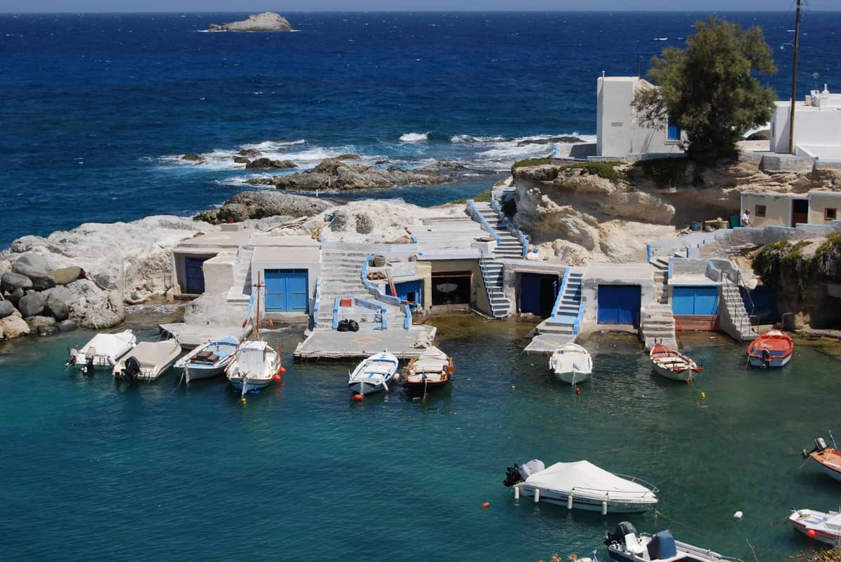
The whole Mandrakia harbor is neatly lined with “sirmata” (boathouses) painted in bright colors, offering a truly impressive sight to the visitor.
Mandrakia has started to develop and now has a tourist restaurant and some rooms. It is a beautiful, quiet, picturesque corner of the island.
Mandrakia is a small fishing village on the north coast of the island of Milos, where a harbour, a church and a short beach share one cove. Boathouses painted in strong colours stand around the water. This page shows where Mandrakia lies, how the settlement is arranged and what the boathouses are used for.
Mandrakia is one of the fishing villages of Milos, a group of coves where the same rock-cut boathouse repeats. The first section places Mandrakia on the map and reads its layout. The second section turns to the sirmata, the boathouses cut into volcanic rock, and compares them with the same building on Kimolos.
Where does Mandrakia lie on Milos, and how is the settlement laid out?
Mandrakia lies on the north coast of Milos, 9 km east-north-east of Plaka and 4 km north of Adamantas. The settlement is a single cove with a small harbour, a ring of boathouses, a church above them and a short beach.
Two settlements fix the position of the village. Plaka, the capital and seat of the municipality, is the first reference, and Mandrakia lies 9 km east-north-east of it. Adamantas, the main port of the island, is the second, and the village lies 4 km north of it. The port is the nearer link, at less than half the distance of the capital. Along the north coast, the list of beaches from west to east places Mandrakia between Sykia and Sarakiniko.
Mandrakia appears officially as a separate settlement in 1961, inside the community of Triovasalos. Under the Kleisthenis administrative plan, it still belongs to that community, within the municipal unit and the municipality of Milos. Triovasalos has been the seat of the community since 1926. The village stands on two neighbouring hills at 143 meters, together with Pera Triovasalos, and the pair forms the commercial and daily centre of Milos, with banks, public services, cafes and shops.
The census figures show how small Mandrakia is. The count was 5 in 1961, then 1 in 1971 and 1 in 1981. It rose to 2 in 1991 and stayed at 2 in 2001 and 2011. The 2021 census recorded 13 residents, and the jump from 2 to 13 is the largest change in the series. The island as a whole counted 5,302 residents in 2021, so Mandrakia holds a very small share of the population of Milos.
The cove reads in layers from the top down. The church of Zoodochos Pigi rises above the boathouses and dominates the village. The sirmata stand around the small harbour, built to keep the boats of the fishermen safe, and a small beach of fine dark grey pebbles, about 150 meters long, with tamarisk trees lies in front of the houses. Together they make the cove a settlement, a beach and a small harbour in one place.
- Spelling: The name is written Μανδράκια or Μαντράκια in Greek.
- Community: The community of Triovasalos also takes in Kaminia, Mytikas, Pachaina, Phylakopi and the Glaronisia islets.
- Rooms: Rooms for rent and a traditional restaurant facing the Aegean stand in the village.
- Pikropigi: The hot springs of Milos come from hydrothermal action, and Pikropigi lies at Mandrakia.
- Triovasalos: The village of Triovasalos was one settlement with Pera Triovasalos until 1908.
In short, Mandrakia is a small cove on the north coast, tied to Plaka and Adamantas by distance and to Triovasalos by administration. Its population fell to a single resident and then rose to 13 over six decades. The church, the boathouses, the harbour and the beach stand close together, and the boathouses are the part that defines the village, so the next section looks at them.
What are the sirmata of Mandrakia, and what do the boathouses hold?
The sirmata of Mandrakia are boathouses dug into volcanic tuff beside the sea. They store the boats and the fishing gear of the fishermen and also serve as temporary homes. Painted in bright colours, they surround the small harbour and are the main feature of the village.
Tuff is the rock behind the sirmata of Mandrakia. It is a pyroclastic rock formed from material thrown out by volcanoes, and its texture is soft and light. Builders have used tuff since antiquity because it is easy to work. In Greece it occurs in western Macedonia and Thrace and on Cycladic islands such as Santorini, Milos and Kimolos. Settlements of this kind are built in small coves, dug into soft rock or set in natural cavities of the rocks, and Mandrakia follows that pattern.
The use of the sirmata has two sides. Across the fishing villages of Milos they first protected the boats of the fishermen in winter and in bad weather. Later they became houses of the fishermen and places for summer stays. At Mandrakia the sirmata store the boats and the gear of the fishermen today, and they also serve as temporary homes, so one hollow in the rock works as a shed and as a place to stay.
The building type is not limited to Milos. Kimolos, the neighbouring island, lies across a strait only 1 km wide, and the small harbour of Goupa there has sirmata of its own, also called magazia, a word for shops. They are caves cut into soft rock and closed with coloured wooden doors, and local people keep their boats there in winter. Mandrakia belongs to the same family of boat sheds, a characteristic feature of Cycladic architecture.
- Colour: The sirmata around the harbour of Mandrakia are painted in bright colours.
- Name: The word comes from fishermen dragging boats out of winter shelter into the sea.
- Materials: Cycladic builders work with local, unprocessed materials, and the builders are the users themselves.
- Psathi: Carved slipways in the harbour of Psathi on Kimolos are also called sirmata.
- Neighbours: Sirmata stand mainly at Klima, Mandrakia and Firopotamos on Milos.
The boathouses of Mandrakia therefore join a fact of geology to a way of living. Soft volcanic tuff lets fishermen dig hollows at the water edge, and the hollows hold boats, gear and temporary homes. Because the same building stands at Klima, at Firopotamos and on Kimolos, the sirmata read as one local example of a shared island habit, painted in bright colours around a small harbour.


What do the church and the seasons give to village life in Mandrakia?
Mandrakia gathers its village life around the church of Zoodochos Pigi, which stands above the boathouses, and around a small harbour for fishing boats. The year divides into mild, rainy winters and dry, warm summers, and Milos is a popular destination in the warm season.
The church of Zoodochos Pigi dominates the top of Mandrakia. The village is a small group of houses, with the church above them and the harbour next to them. The name means the Life-giving Spring, a title of the Mother of God. Mandrakia belongs to the community of Triovasalos, and the parish of Agios Spyridon in Triovasalos counts a church of Zoodochos Pigi among its churches. That church has a small single-arched bell tower at the entrance and a simple interior.
The church year gives this dedication a fixed place. The feast of the Life-giving Spring falls on Bright Friday, the Friday after Easter. Bright Friday belongs to Bright Week, the week of services that begins on Easter and runs up to the following Sunday. That date puts the church of Mandrakia in the early part of the year, before the dry months begin. The settlement itself is small, with 13 residents in 2021, so the church marks the village more than any crowd does.
The seasons of Milos set the pace of Mandrakia. The climate is Mediterranean, with mild, rainy winters and warm to hot dry summers. The mean daily maximum is 12.9 degrees Celsius in January and 28.1 in July. Rainfall reaches 90.3 millimetres in December and 0.3 in July, and days with at least 1 millimetre of rain number 9.0 in December and 0.1 in July. Milos is a popular tourist destination during the summer.
- Church: Zoodochos Pigi stands above the sirmata of Mandrakia.
- Feast: The Life-giving Spring is kept on Bright Friday.
- Community: Mandrakia belongs to Triovasalos, in the municipality of Milos.
- Harbour: The small harbour keeps the boats of the fishermen safe.
- Visitors: Rooms for rent and a traditional restaurant serve the village.
Church, harbour and weather give Mandrakia a plain yearly rhythm. The feast of the Life-giving Spring comes after Easter, the rainy months of winter come before it, and the dry summer follows. The village has rooms for rent and a traditional restaurant with a view of the Aegean, while the harbour still does the work it was built for: it keeps the boats of the fishermen safe.
How do the rocks, the sea and the wind shape a swim at Mandrakia?
Mandrakia offers a small, quiet beach of almost 150 metres with fine dark grey pebbles, on the north coast of Milos. The wind decides the swim: south winds favour the beaches of the north coast, while the north winds of summer favour the bay and the south side.
The beach of Mandrakia lies in front of the village houses, beside the small harbour. It is small, quiet and sandy, almost 150 metres long, with fine dark grey pebbles and tamarisk trees. Swimmers at Plathiena, a beach of fine white sand on the same coast, have views of Mandrakia. In summer, the mean daily maximum is 27.1 degrees Celsius in June and 27.6 in August. A swim at Mandrakia therefore takes place beside the working harbour, which is lined with sirmata painted in bright colours.
Rock shapes the cove as much as the beach does. The sirmata of Mandrakia are small houses dug into volcanic tuff beside the sea. Milos is of volcanic origin, with tuff, trachyte and obsidian among its ordinary rocks, and its bays hold pebbles surrounded by white, red, yellow or black stones, so the colour of the rock changes from bay to bay. Opposite the settlement, to the north, lies the rocky islet of Kara, east of the bay of Firopotamos.
Wind sets the state of the sea at Mandrakia, as it does across the Aegean. The meltemi is a strong, dry north wind that blows in summer, returns after a pause in June and continues until early October, with an average force of 6 to 7 on the Beaufort scale. Its weather is a clear sky and a wavy sea. The dry air makes the sky look deep blue and improves visibility. The wind is strongest by day, in the hottest hours, and it eases at night.
The island has over 75 small and large beaches, so the wind direction is a useful way to choose among them. The advice for Milos is to choose by that direction. In the meltemi and other north winds, the beaches inside the gulf are the better choice, and the south side of the island is better still. When the wind comes from the south, the beaches on the north side are the ones recommended. Mandrakia lies on the north coast, so it belongs to that second group.
- Beach: Almost 150 metres of quiet shore with fine dark grey pebbles.
- Trees: Tamarisk trees grow along the beach of Mandrakia.
- Rock: The sirmata are cut into volcanic tuff beside the sea.
- Sky: The dry air of the meltemi gives a deep blue sky.
- Wind: South winds favour the north coast, and north winds favour the bay.
A swim at Mandrakia starts with the wind. On a day of south wind, the north coast is the side to choose, and the dark grey pebbles and the quiet shore are the setting. On a day of meltemi, a clear sky comes with a wavy sea, and the bay or the south side is the better choice. The page on the beaches of Milos sets the cove beside the other beaches of the island.
How do travellers reach Mandrakia on foot, by bike or by car?
Mandrakia lies on the north coast of Milos, about 4 km north of the port of Adamantas, while Triovasalos and Plaka stand on the hills inland. Walkers descend to the harbour from those villages, and bikes and cars follow the road network down to the shore.
A walk to Mandrakia from Plaka starts high, because the capital stands at 220 metres, and it ends at a harbour beside the sea. The way out is downhill and the way back is uphill. From Plaka the north coast lies 3 km away at Firopotamos and 5 km away at Sarakiniko, and Mandrakia sits on that shore between the two. Mandrakia belongs to the community of Triovasalos, and from that village the climb back is shorter, since its two hills stand at 143 metres.
On two wheels, the dirt roads of Milos give a second option, since the network is the largest in the Cyclades and leads to coastal sites, chapels and mines. In places the tracks are very difficult. From the port, the road toward Plaka meets Triovasalos first, so a rider from Adamantas passes through that village before the capital. Triovasalos holds banks, public services, cafes and shops, which makes it a place to stop before the ride down to Mandrakia.
Car traffic is prohibited inside Plaka, so a driver from the capital starts outside the village. The city buses of Milos serve parts of the island in summer, and the fare is bought on board. Sarakiniko, the next shore east of Mandrakia, is easy to reach by car and by bus. Taxis wait at the port and the airport, which suits a traveller who reaches Mandrakia without a car.
- Adamantas: The main port of Milos stands on the north-eastern shore of the gulf.
- Triovasalos: This is the first village after the port on the road to Plaka.
- Plaka: The capital stands at 220 metres and bans car traffic inside the village.
- Taxis: Fifteen taxis work on Milos, and they wait at the port and the airport.
- Dirt roads: The largest dirt-road network in the Cyclades ends at coastal sites, chapels and mines.
Mandrakia is reached from three bases that follow one line from the port: Adamantas at the harbour, Triovasalos on its two hills and Plaka above them. Plaka at 220 metres and Triovasalos at 143 metres set the height a walker climbs on the way back, while Adamantas starts at the harbour. All three routes end at the same small harbour on the north coast, where the sea closes the road.

What lies near Mandrakia on the north coast?
Mandrakia sits on the north coast between Firopotamos on the west and Sarakiniko on the east. Papafragas lies far to the east along the same shore, and Plaka stands inland on its hill. Each place near Mandrakia offers a different kind of rock, beach, cave or view.
Sarakiniko lies on the north coast east of Mandrakia, and its name comes from the Saracen pirates who found shelter in the caves that waves have cut along the white volcanic coast. The shore also records the history of the volcano: a layer about 50 metres thick holds sandstone with pumice breccia and mudstone that contains fossils, and fossils of shells, sea urchins and barnacles have been found in the area. Visitors carving their names into the rock led the municipality to set a fine in 2015.
West of Mandrakia, the fishing village of Firopotamos lies in a small bay at the northern edge of Milos. Boat shelters called syrmata surround the creek, as they do at Mandrakia and at Klima. The shelters keep boats through the winter, and in summer the owners use them as holiday homes. The village was listed as a separate settlement in 1920, when it joined the community of Milos, and it had 4 residents in 2011 and 2 at the 2021 census.
Far to the east on the same coast lies Papafragas, which holds three caves. The deep sea cave lets swimmers move through turquoise water between grey and white rocks toward the open sea. In Byzantine times the beach served as a base for pirates, and the name comes from the last Frank Pope, who used the beach to shelter his boat. Between Mandrakia and Papafragas the coast passes Sarakiniko, Mytakas, Alogomandra, Agios Konstantinos, Pachaina and Kapros.
Inland, Plaka is the capital of the island. Its name comes from the flat ground on which the first inhabitants built their houses when the Castle no longer had room for the whole population. Cobbled alleys, first laid out as protection from pirates, run between traditional shops, restaurants and cafes. The Venetian castle of the 13th century stands at the top of the hill. Plaka had 902 residents at the 2021 census, against 13 at Mandrakia.
- Firopotamos beach: The small sandy beach is organised, with a beach bar and tamarisk trees.
- Sarakiniko rock: Ship bollards are still carved into the rock where pirates once sheltered.
- Sarakiniko beach: The sandy beach is 10 metres long and sits in a small natural harbour between the rocks.
- Papafragas beach: The small beach lies among light rocks beside the ruins of Fylakopi.
- Plaka view: The castle hill gives views of the bay and the neighbouring Cycladic islands.
Mandrakia fits between named places that each show a different side of the island. Firopotamos lies to the west, Sarakiniko to the east and Papafragas far along the shore, while Plaka stands inland on its hill. Taken together, the stops give the north coast a clear order, from a fishing creek through white rock and a pirate cave to the capital with its Venetian castle.
Where can visitors eat and stay near Mandrakia?
Mandrakia has a traditional restaurant with a view over the Aegean and rooms for rent, so one small village covers both a meal and a bed. Adamantas, 4 kilometres south, is the main port and the largest tourist centre of the island.
Food at Mandrakia centres on a traditional restaurant with a view over the Aegean. The settlement is one of the small fishing ports of Milos, built in a cove, so the meal sits beside the working harbour. The village counted 13 residents at the 2021 census. Across the island, restaurants, taverns, steakhouses and wineries serve everything from fresh fish to international cuisine, and the dishes named as island favourites include lobster pasta, octopus grilled or cooked in wine, and fresh fish.
The sea explains the fish on the plate. Milos has a volcanic geology, and its reefs, caves and rocky shores are natural habitats for a wide variety of fish. The waters hold red mullet, red snapper and sea bream, together with octopus, squid, cuttlefish and lobster. Fishing here uses nets, longlines, trolling and rods, as well as underwater spearfishing. The fish vary with the season and the region, so the plates of a fish tavern on this coast follow the catch of the period.
Rooms for rent are the lodging named at Mandrakia itself. Adamantas lies 4 kilometres to the south as the main port and the largest tourist centre of Milos, which makes it the larger tourist base. Plaka, the seat of the municipality, lies about 9 kilometres away. A stay in the village means a room in a fishing settlement beside the harbour, while a stay in Adamantas means a busier town with the port at hand.
The boathouses of Milos are called syrmata. They are cave dwellings by the sea, painted in bright colours, and they first protected the boats of fishermen in winter and in bad weather. Later they turned into fishermen’s houses and summer accommodation. Dug into volcanic rock, they form a typical feature of Cycladic architecture. The name comes from the way fishermen dragged the boats out of the inner space, where the boats sheltered from winter weather, back into the sea. At Mandrakia the harbour still works as a fishing harbour.
- Restaurant: The traditional restaurant at Mandrakia looks over the Aegean.
- Rooms: Rooms for rent are the lodging named in the village.
- Base: Adamantas, 4 kilometres south, is the largest tourist centre of the island.
- Capital: Plaka, the seat of the municipality, lies about 9 kilometres from the village.
- Harbour: Boats and fishing gear stay in the syrmata beside the sea.
Eating and staying near Mandrakia combine one restaurant, rooms for rent and a working fishing harbour, with Adamantas close enough to widen the choice. The village keeps its own harbour and its own colourful boathouses, and the sea in front of it supplies the fish that Milos serves. The page on accommodations in Milos covers the choice of places to stay across the island.

What do visitors ask about Mandrakia?
Mandrakia is a traditional fishing village on the north coast of Milos, 4 kilometres north of Adamantas. It has rooms for rent, a restaurant, a small harbour and a sandy beach of almost 150 metres. The answers cover eating, lodging, distances, boathouses and residents.
Is there a restaurant in Mandrakia?
Mandrakia has a traditional restaurant with a view over the Aegean, beside a small fishing harbour. Adamantas, 4 kilometres south, is the main port and the largest tourist centre of Milos, and restaurants across the island serve everything from fresh fish to international cuisine. The harbour and the port are two different settings.
Are there rooms to rent in Mandrakia?
Rooms for rent belong to the facilities of the village, together with the restaurant. The settlement is a fishing village of 13 residents at the 2021 census, so a stay there means a harbour setting beside the boats. Adamantas, the main port, lies 4 kilometres away, and Plaka, the seat of the municipality, lies about 9 kilometres away.
What fish live in the sea near Mandrakia?
Red mullet, red snapper and sea bream live in the waters of Milos, together with octopus, squid, cuttlefish and lobster. Reefs, caves and rocky shores are the natural habitats of this variety of fish, and the volcanic geology makes the island a very rich fishing place. The fish vary with the season and the region of the island.
How far is Mandrakia from Adamantas and Plaka?
The village lies about 4 kilometres north of Adamantas, the port of Milos, and about 9 kilometres east-north-east of Plaka, the seat of the municipality. It stands on the north coast of the island, where small fishing ports are built in coves. Adamantas is the main port and the largest tourist centre, while Plaka is the current capital.
Who lives in Mandrakia today?
At the 2021 census Mandrakia had 13 residents. The settlement was officially recorded as a separate settlement in 1961, counted under the community of Triovasalos, and it still belongs to that community within the municipal unit of Milos. Fishermen also use the syrmata of the harbour as temporary homes beside the boats and the gear.
Can visitors sleep in a boathouse at Mandrakia?
The boathouses of Mandrakia store boats and fishing gear and serve as temporary homes for fishermen, so rooms for rent are the lodging named for the village. Across Milos the same cave dwellings by the sea later became fishermen’s houses and summer accommodation. The same building type stands at Klima and Firopotamos, the other two main settlements with syrmata.