
Achivadolimni beach is the largest beach on the island of Milos. It lies on the shore inside the big gulf, east of the port of Adamas. White sand and shallow blue water mark the whole shore. The sand splits into a quiet part and a busy part.
This page gives the main facts first. It then follows the coastal road from Adamas to the sand. The later parts cover the name, the lagoon and the wind. They also cover the way in, swimming, nearby places and the best time to go. They help first-time visitors plan a trip to Achivadolimni beach.
What is Achivadolimni beach at a glance?
Achivadolimni beach is the largest beach on Milos, with white sand and shallow, deep blue water. It lies inside the gulf and divides into two sandy stretches. One stretch is quiet and secluded, and the other is busy and organised.
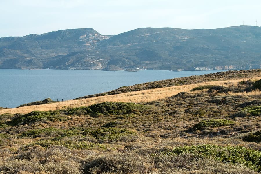
Milos has no larger beach than Achivadolimni beach. One list of the island’s shores names 90 beaches, and this one is the biggest. White sand covers the shore. The water next to the sand is shallow, and it shows a deep blue colour. The same list places 25 beaches inside the gulf.
At Achivadolimni beach, the shore divides into two sandy beaches. The first is quieter and secluded, which means tucked away. The second is busy and organised. It has a beach bar and restaurants. Visitors who want peace choose the first stretch. Those who want a drink or a meal choose the second.
Organised camping is available at the beach. A bus also reaches Achivadolimni beach, so a car is not the only way in. The beaches in the western half of Milos are isolated, and this one is not. It also lies near the harbour town of Adamas.
Fans of surf and kite-surf choose this shore. Kite-surf means riding a board while a large kite pulls the rider across the water. The natural bay of the island offers maximum safety for these sports. Papikinou, another gulf beach, is named for the same sports.
The name comes from the pond opposite the beach and its clams. It is also written Hivadolimni. Achivadolimni is also a wetland, the largest natural one in the Cyclades. A wetland is low ground that stays wet. Migratory birds stop there, and the area belongs to the protected Natura network.
- Rank: It is the largest beach on Milos.
- Setting: It lies inside the gulf of Milos.
- Parts: Two sandy beaches share the shore, one quiet and one busy.
- Camping: Organised camping is available at the beach.
- Access: A bus reaches the beach.
Achivadolimni beach brings size, white sand, two sandy stretches and a bus link to one shore. For the wider picture of the island’s coast, see the page on the beaches of Milos. The next section places the beach on the map.

Where does Achivadolimni beach lie in the gulf of Milos?
Achivadolimni beach lies inside the gulf of Milos, east of the port of Adamas. The coastal road runs east from Adamas past Papikinou beach. It then passes the old salt works at Alykes and reaches the sand. The turn to Zefyria branches off the same road.
Milos curls like a horseshoe, and the gulf fills the gap inside it. The gulf is the hollow of an old volcanic crater. Its mouth opens to the north-west, and the water leaves two halves of nearly equal size. A narrow neck of land, no wider than 2.2 kilometres, joins them.
Adamas, the harbour town, stands on the shore of this gulf. Lagkada is the closest beach to the port. Papikinou lies 1 kilometre east of Adamas. Achivadolimni beach comes further along the same coastal road.
The coastal road to Achivadolimni beach leaves Adamas heading east. After about 500 metres, the road passes the mining museum of Milos. Papikinou beach begins right after the museum. Its sand carries on as far as Alykes, so one long shore leads toward the old salt works.
Alykes comes just before the island’s airport. Its old salt works are abandoned and now form an important wetland. After Alykes, the road meets a rock called sugar lava. This lava breaks into big and small blocks. It appears from the place called Mavra Gremna up to the beach.
A crossroads lies 2.3 kilometres past the mining museum. A left turn there leads to Zefyria. The village lies at the heart of east Milos. It is 5.5 kilometres from Adamas and 9 from Plaka. Rivari, another gulf beach, is a natural lagoon where migratory birds find refuge.
- Port: Adamas is the harbour town where the coastal road begins.
- Closest beach: Lagkada is the nearest beach to the port.
- Next beach: Papikinou lies 1 kilometre east of Adamas.
- Village: Zefyria is a farming village in the centre of east Milos.
- Lagoon: Rivari has low hills and small plants around it.
Achivadolimni beach is easy to place on the map. It sits inside the gulf, on the coastal road east of Adamas. Papikinou and the salt works of Alykes come before it. Zefyria stands in east Milos, and the Rivari lagoon lies on the same gulf. The next parts explain the name and the sand.
What does the name of Achivadolimni beach mean?
Achivadolimni beach takes its name from a small pond that lies opposite the sand. The pond is full of clams, and achivades, the Greek word for clams, opens the name. A shorter form, Hivadolimni, names that same place on the island.
The name of Achivadolimni beach does not describe the sand. It describes a pond. The pond is small, a little lake that faces the shore. Clams live in it. A clam is a shellfish with two shells. It spends its life half buried in sand or mud.
Greek makes the meaning clear. The word achivades, written αχιβάδες in Greek letters, means clams. The first half of the name repeats that word. The second half points to the lake. Together, the two halves describe a lake with clams in it.
Clams once crowded the pond, and the shellfish gave the beach its name. The pond holds a great number of them even now. Achivadolimni beach is therefore named after a feature of the land, not after a person. A plain description like that is easy to remember.
Hivadolimni is the other name of the beach. It is the same word without the opening letter A. In Greek letters, Αχιβαδόλιμνη becomes Χιβαδόλιμνη. Both forms point to one place. Greek writing about the past of the island uses the short form too.
- Origin: A small pond opposite the shore gave the beach its name.
- Clams: The pond is full of these shellfish, which have two shells.
- Lake side: The second half of the name points to the pond itself.
- Short form: Hivadolimni is the same name without the opening letter A.
- Greek spelling: The full name is written Αχιβαδόλιμνη in Greek letters.
The name of Achivadolimni beach works like a small label on a map. It tells a reader that clams, a pond and a stretch of sand belong to one place. The label is easy to spot in either spelling, since only the first letter changes.
What are the sand and the shallow water like at Achivadolimni beach?
Achivadolimni beach has pure white sand and shallow water with a deep blue colour. It is the largest beach on the whole island of Milos. The shore splits into two sandy stretches, and the first stretch is quieter than the second.
Size comes first. Achivadolimni beach is the largest beach on Milos. It stands inside the gulf, the large bay that cuts deep into the island. That bay holds twenty-five named beaches. This one is the biggest of the whole island, not only of the bay.
The sand is pure white, and it forms two separate stretches. The first stretch is quieter and more secluded. The second stretch is busier and organised. Between them, the two stretches of Achivadolimni beach give a choice of calm or company.
The water at Achivadolimni beach is shallow, meaning the sea floor lies close to the surface. Shallow water matters to families with small children. The page on Milos with kids covers more of that side of the island.
Greek keeps two ideas apart with two words. Ρηχά means shallow, and βαθυγάλανα means deep blue. The first word is about depth. The second word is about colour, not depth. Together they describe a sea that is shallow yet deep blue.
Volcanic rock lines the way to the shore. A rock called sugar lava lies broken into blocks along the road to the beach. From the beach toward Agia Marina, lava with a glassy texture appears. Its age is put at 0.9 to 1.1 million years.
- Size: The largest beach on the island sits inside the gulf.
- Sand: The sand is pure white.
- Water: Shallow water with a deep blue colour fronts the shore.
- Stretches: Two sandy stretches share the beach, one quiet and one busy.
- Rock: Sugar lava lies in blocks along the road to the beach.
In short, Achivadolimni beach offers pure white sand and shallow blue water. It also has more room than any other beach on Milos. Two stretches of sand give a choice between a calm corner and a busy, organised one. Volcanic rock lines the road that reaches the beach.
What are the lagoon and the plants around Achivadolimni beach like?
Achivadolimni beach faces a pond that forms the biggest natural wetland among the Cyclades islands. Birds on long journeys rest there, inside a zone protected by Natura rules. Rivari, in the same gulf, has a natural lagoon with low hills and small plants around it.
A wetland is land that is flooded or soaked with water. The flooding lasts all year or only for part of the year. A wetland forms a belt between open water and dry land. The pond opposite Achivadolimni beach is such a place. No other natural wetland in the Cyclades is bigger.
The wetland opposite Achivadolimni beach belongs to the Natura area. Natura 2000 is a group of nature protection sites inside the European Union. The wetland is also an important stop for migratory birds. These birds travel between breeding and wintering grounds twice a year. A seasonal crowd gathers at the pond.
Rivari is another beach inside the gulf. It is a natural lagoon. A lagoon is a shallow pool cut off from the sea by a narrow strip of land. The lagoon is a refuge for migratory birds. Small plants and low hills surround the beach. Tourism has developed little on this west side of Milos.
Olive, orange and cypress trees grow on the island, and so do tamarisk, juniper and arbutus. Tamarisk is a shrub or small tree that grows on salty soil. Dry conditions keep the plant cover on Milos thin. Even so, these trees add green to the hills.
Western Milos adds more variety. Plants, herbs and wildflowers grow there in large numbers. A forest of cypresses with horizontal branches is a rare habitat, and its trees have stood for centuries. Protected birds live in the same area, among them a rare migratory falcon.
- Wetland: The pond opposite the beach holds first place among natural wetlands of the Cyclades.
- Protection: Natura 2000 status covers nearly the whole west of Milos.
- Variety: Over 800 taxa, meaning named kinds of living things, live in that western zone.
- Endemic: Thirty-five of those taxa exist only in Greece.
- Lagoon: At Rivari, travelling birds find a calm lagoon to shelter in.
Around Achivadolimni beach, water, birds and plants share one protected landscape. The pond holds clams. The wetland hosts passing birds. The dry island carries a thin cover of trees and herbs. Rivari adds a second lagoon in the same gulf.
Why does Achivadolimni beach stay calmer on windy days?
Achivadolimni beach lies inside the gulf of Milos. The local rule for meltemi days is to choose gulf beaches. The gulf is a volcanic crater hollow with land on both sides. Its water stays gentler than the open coast.
The meltemi is a summer wind from the north that sweeps over the Aegean Sea. It brings dry air and cools the summer heat. Skies stay clear, but the sea surface turns choppy. The wind peaks in the afternoon. After dark it can ease, though a spell can also run on without a break.
Milos has a simple rule for these days, and Achivadolimni beach fits it. In a meltemi or any north wind, a beach inside the bay is the better pick. The south coast of Milos is better still. In a south wind, the choice flips to the north coast.
The bay explains the rule. Milos is shaped like a horseshoe, and the bay fills the gap between its arms. The bay fills the bowl of the island’s principal crater. It splits the island into two nearly equal parts. Among Mediterranean natural bays, it ranks as both large and safe.
Other gulf beaches follow the same pattern. Papikinou, also inside the gulf, ranks among the beaches with the gentlest waves on Milos. Achivadolimni beach belongs to the same group, one of 25 beaches inside the gulf. Calm here means calmer than the open coast, not windless.
The wind still reaches Achivadolimni beach, which is why surf and kite-surf fans like it. Swimmers who want the flattest water can plan around the afternoon peak, since the wind is strongest then. A separate page explains the best time to visit Milos and the months of the meltemi.
- Wind: The meltemi blows from the north in summer and cools the heat.
- Rule: In a north wind, pick a gulf beach or a south-side beach.
- Gulf: Achivadolimni beach lies inside this crater hollow.
- Papikinou: This gulf beach, east of Adamas, is known for gentle waves.
- Limit: Calm means gentler than the open coast, not windless.
Achivadolimni beach suits north-wind days because the gulf wraps land around the water. The island’s rule still holds when the wind changes. A visitor checks the direction first, then picks the coast that faces away from the wind. Papikinou and the other gulf beaches share this advantage.

How do visitors reach Achivadolimni beach from Adamas?
Achivadolimni beach lies along the coastal road that leaves Adamas and follows the gulf shore. The road passes Papikinou and the salt pans of Alykes on the way. A bus serves the beach, and taxis wait at the port.
The road to Achivadolimni beach starts in Adamas, the main port of Milos. Visitors arriving by sea land here. The town is also the biggest tourist hub on the island. It sits at the northern end of the gulf. A coastal road leaves it toward the east.
Landmarks mark the first stretch. About 500 m from Adamas stands the mining museum, and Papikinou beach begins right after it. At about 2 km, a restored kaolin plant, once a works for white clay, stands by the road. The road keeps to the coast along this whole stretch.
Next come the port works at Kanava. Then the road reaches Alykes, where old sea-salt pans lie abandoned just before the airport. Today the pans form a wetland, a marshy area that holds water. Past them, broken lava blocks, nicknamed sugar lava, line the road all the way to the sand.
Public transport also serves the shore. Achivadolimni beach is on a bus route, which helps visitors without a car. Taxis also wait at the harbour and the airport. The island has 15 taxis in all. The airport lies near Alykes.
The main road does not end at the sand. It runs on to the church and monastery of Agia Marina, built from local lava and volcanic rock. From there a dirt road goes down to a quiet beach that overlooks the whole port.
- Start: Adamas, the main port, stands in the north of the gulf.
- Early stretch: Papikinou beach begins right after the mining museum.
- Salt pans: Alykes, with its old salt pans, lies just before the airport.
- Bus: The beach is accessible by bus.
- Taxis: A visitor finds taxis at the harbour and at the airport.
Reaching Achivadolimni beach takes one road and a handful of clear landmarks. The route leaves Adamas, runs past Papikinou and the salt pans of Alykes, and ends at the beach. A bus and taxis give other ways to arrive, so a car is not required.
What can swimmers and surfers do at Achivadolimni beach?
Achivadolimni beach offers easy swimming in shallow, deep blue water beside white sand. The sheltered bay around it also suits windsurfing and kitesurfing. This beach is an ideal choice for both sports, and the bay offers them maximum safety.
The sea at Achivadolimni beach is shallow and a deep blue colour. White sand lines the shore. Milos counts it as the largest beach on the island. Swimmers enter the water of the bay, not the open sea. The name is also spelled Hivadolimni.
The beach divides into two sandy parts. The first part is quieter and set apart. The second part is busy and organised, and it has a beach bar and restaurants. Swimmers choose the side that matches their plans, either calm and apart or lively and close to food.
The water belongs to the great bay of Milos. The island curves like a horseshoe around it. The bay occupies the main crater of the island’s volcano. It works as a natural harbour. The volcano last erupted 90,000 years ago and is now thought to be dormant, meaning asleep.
Windsurfing is a water sport that mixes sailing and surfing. The wind does the pushing. It is also called sailboarding. Achivadolimni beach suits this sport well. The weather of Milos is ideal for it. Riders enjoy the freedom of the board on the bay.
Kitesurfing uses a large kite. The kite catches the wind and pulls a rider across the water on a board. The sport mixes parts of surfing, windsurfing and paragliding. Papikinou, another beach of the bay, is named for the same two sports.
- Swimming: The shallow, deep blue water lies over white sand.
- Windsurfing: A rider steers a board with a sail across the bay.
- Kitesurfing: A large kite pulls the rider over the turquoise water.
- Safety: The natural bay keeps Achivadolimni beach very safe for these sports.
- Quiet part: The first of the two sandy parts is the quieter and more secluded one.
Swimming and wind sports share one bay at Achivadolimni beach. The water is shallow and the sand is white. The beach has a quiet part and a busy part. Amateurs and experts of both sports find the weather of Milos ideal.
What lies near Achivadolimni beach?
Near Achivadolimni beach lie the old capital Zefyria, the Rivari lagoon and the harbour town of Adamas. A row of other beaches also lines the inner bay, among them Fatourena, Empourios, Lagkada and Papikinou. Each place tells a different story.
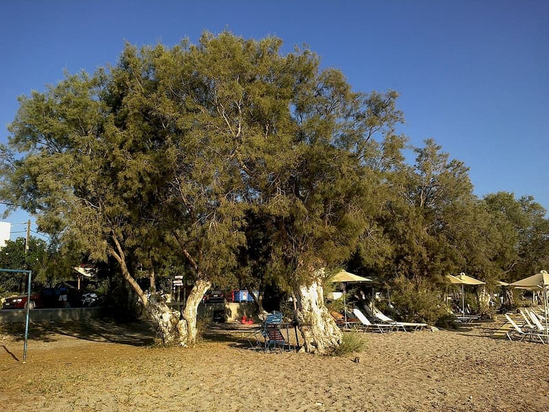
The village of Zefyria stands in the centre of East Milos. Venetians founded it in the 13th century. The presence of pirates helped it grow into the capital of the island. Adamas is 5.5 km away, and Plaka, the municipal seat, is 9 km away.
Earthquakes damaged the village. Gases from cracks in the ground brought outbreaks of disease. The people left, and the village was abandoned in 1767. Today it is a lively farming village. It keeps the former cathedral church of Milos, Panagia Portiani, beside the walled church of Agios Nikolaos.
Near Achivadolimni beach, Rivari is a natural lagoon, meaning a pool of water beside the sea. Migratory birds use it as a refuge. Low hills and small shrubs lie around the shore. The west side of Milos has seen little tourism, so Rivari is a very private place.
Adamas is the harbour town of Milos. It sits on the north-eastern shore of the bay. Refugees from Crete settled there in 1831. Today their descendants are known as Milokritikoi. Today the town leads the island in culture and trade. The census of 2021 counted 1,268 people there.
The gulf of Milos holds 25 beaches. Achivadolimni, Papikinou, Lagkada, Rivari, Fatourena and Empourios all sit on that list. Together they form a string of sandy and quiet spots along the inner bay. Of these, Achivadolimni beach and Papikinou are the two picked for wind sports.
- Papikinou: A large beach, 1 km east of Adamas, with mild waves and shade trees.
- Lagkada: The beach nearest to the port of Adamas has clear water, golden white sand and tamarisk shade.
- Fatourena: From Achivadolimni beach, the main road passes Agia Marina, then a dirt road reaches this blue beach.
- Empourios: This old commercial port has its own beach and lies past Fatourena and Rivari.
- Agia Kyriaki and Paleochori: The road through Zefyria leads on to these two beaches.
Each of these places adds a story to a visit to Achivadolimni beach. Zefyria brings history, Rivari brings birds, and Adamas brings the port. The bay beaches add more sand and water inside the same gulf. Pirates, earthquakes and refugees all left their mark on this part of Milos.
Where can visitors stay near Achivadolimni beach?
Near Achivadolimni beach, visitors stay in Adamas, the port town, or in an inland village like Zefyria. Adamas, on the gulf, has town services, museums and nightlife. Zefyria is a small farming village. The beach itself also has organised camping.
The port town of Adamas works as the main base for a day at Achivadolimni beach. Its white houses have small courtyards decorated with flowers, and its streets are narrow and quiet. Visitors can rest there by day. Evenings bring nightlife and entertainment. The town also supplies what a comfortable holiday needs.
A stay in Adamas also puts three museums close by: the maritime, church and mining museums. The church museum sits in the Holy Trinity church, very close to the harbour. A French cemetery of the Crimean War stands near Adamas. Milos Airport lies a short drive from the port.
Zefyria is the inland choice for a stay near Achivadolimni beach. The village lies south-east of Adamas, in the inner part of the island. It is a mainly agricultural village, home to 190 people in 2021. Each 15 August, the village holds one of the island’s major festivals.
Leaving the port for Plaka, a traveller meets Triovasalos first. Its dense housing is built in the shape of an amphitheatre. The village centre has banks, public offices, cafes and shops. The village had 1,379 residents in 2021.
Tripiti stands almost joined to Plaka, beside the Milos Catacombs and the Roman theatre. The village has taverns and wide views of Adamas Bay. Plaka, the island capital, is perched on a rock that overlooks the gulf. Cars are not allowed inside. Only motorbikes and mopeds can enter.
- Adamas: The port town has narrow quiet streets, nightlife and three museums.
- Zefyria: This small farming village lies inland, south-east of the port.
- Triovasalos: This cliff village has banks, public offices, cafes and shops.
- Tripiti: This village sits beside the catacombs and looks over the bay.
- Plaka: The island capital bans cars and overlooks the gulf.
Each base near Achivadolimni beach suits a different trip. Adamas offers a port town with museums and nightlife. Zefyria offers a small farming village inland. Triovasalos, Tripiti and Plaka offer village life above the port. Camping is the fourth choice at Achivadolimni beach itself.
When is the best time to visit Achivadolimni beach?
Achivadolimni beach is at its best in late spring, in June and again in September. These months are warm and dry, and the crowd is thinner than in July and August. Those two months bring the hardest heat, while winter brings the rain.
Summer is the busy season on Milos, and the sun is strong then. At Achivadolimni beach the crowd gathers on the second stretch. A beach bar and restaurants make that part the organised one. The first stretch stays quieter and more secluded.
The climate of Milos is Mediterranean. Winters are mild and wet, while summers run warm to hot and dry. July is the hottest month, with an average daily high of 28.1 °C. August follows at 27.6 °C, and June at 27.1 °C.
Spring suits a quiet visit to the shore. April reaches an average daily high of 18.4 °C. The last spring month reaches 22.8 °C and gets only 13.1 mm of rain. The summer crowd has not arrived yet.
September keeps the warmth of summer. The average daily high is 25.2 °C, and 5.8 mm of rain falls. October cools to 21.3 °C, and the rain comes back with 42.9 mm. By November the high falls to 18.0 °C.
- Wind: Dry northern gusts called the meltemi start in late spring and fade by mid-September, cooling the air.
- Heat spikes: The highest temperature on record for Milos is 44.0 °C, set in June.
- Air: June has the driest air of the year, at 58.8 percent humidity.
- Dry spell: July averages just 0.3 mm of rain, and August only 1.4 mm.
- Winter: Rain peaks in December, at 90.3 mm.
The best month for Achivadolimni beach depends on the kind of day wanted. Warm and quiet days sit in late spring and early autumn. The busy sand sits in July and August. Readers who plan more days on the island can browse activities in Milos for the other days.

What do visitors bring to Achivadolimni beach, and how do they protect it?
Visitors to Achivadolimni beach bring water, shade, sun cream and a bag for litter. The beach lies in a protected nature area. So visitors also stay off the plants, keep away from the birds and take every wrapper home.
Water comes first. Summer days on Milos are dry and hot, and Achivadolimni beach is the largest on the island. A walk along its sand adds up, so each person carries a full bottle. A cool bag keeps the water fresh.
Sun cream goes on before the walk to the shore and again after each swim. A hat and a light shirt help too. The north wind feels cool, but the sun on white sand still burns the skin.
Shade needs a plan. Milos is a dry island with thin plant cover. A visitor brings an umbrella or a cloth cover with a heavy base. A gust of the meltemi lifts a light frame and sends it across the sand.
The lagoon opposite the beach lies in a protected Natura area. Migratory birds rest there on their journeys. Visitors keep to the sand and stay out of the plants. They keep voices low, and every bottle, wrapper and bag goes home with them.
- Hat: A wide brim shades the face and neck when the sun is high.
- Sandals: Light shoes protect the feet on hot sand and on the path to the shore.
- Snacks: Food for the quiet first stretch travels in a closed bag, away from the birds.
- Binoculars: A small pair lets a visitor watch the birds from the sand without going near.
- Bag: A spare bag carries every piece of litter back out.
The needs of Achivadolimni beach are small: water, shade, sun cream and care. The same habits suit every shore on Milos, including Tsigrado beach. A clean shore and an undisturbed lagoon stay in good order for the next visitor. The birds that stop there gain too.
What do visitors ask about Achivadolimni beach?
Achivadolimni beach prompts eight questions. They cover children, shade, parking, food and drink, windy days, the lagoon, the evening light and Zefyria. The short answers below rest on plain facts about the beach, the wind and the climate of Milos.
Is Achivadolimni beach a good choice for children?
The beach has white sand and shallow water, which suits young swimmers. The first stretch is quiet and secluded, and the second stretch has a beach bar and restaurants. An adult stays close in the water, because wind changes the waves fast. Children also need a hat, sun cream and a shady spot between swims.
Is there shade at Achivadolimni beach?
Plants stay sparse across dry Milos, so natural shade is scarce on the shore. A visitor brings an umbrella with a firm base, because the north wind tips a light one. The plants beside the lagoon are no place to sit and stay untouched. The strongest sun falls around midday, so the umbrella matters then.
Where do visitors park at Achivadolimni beach?
Buses run out to the beach as well as cars. Drivers choose firm, open ground and keep wheels off the sand and the plants. In July and August, the busiest months, an early start helps. The second stretch is the organised one, so it draws the biggest crowd.
What food and drink can visitors find at Achivadolimni beach?
The second stretch of Achivadolimni beach has a beach bar and restaurants for meals and cold drinks. The first stretch is quieter, so it suits a picnic carried in from outside in a closed bag. On either stretch, visitors carry water for the sun and take every bottle and wrapper away with them.
How does the wind change a day at Achivadolimni beach?
From late spring to mid-September, a dry northern wind called the meltemi sweeps the Aegean. Afternoons bring the hardest gusts, and the gusts can drop at night. Windsurfers and kite-surfers pick Achivadolimni beach for this wind. The natural bay of Milos gives them a safe setting. Swimmers weigh down towels and watch the waves.
What is the lagoon beside Achivadolimni beach?
The lagoon is the pond opposite the beach, and clams once filled it. In all the Cyclades, no natural wetland covers more ground. Flocks pause there on their seasonal flights. Visitors look from the shore, keep voices low and stay out of the plants and the water. A calm look from the sand disturbs nothing.
What is the evening light like at Achivadolimni beach?
White sand reflects the low evening sun, and summer skies on Milos stay clear when the meltemi blows. Evenings are calmer, since the north wind can fade at night. A July night still averages a low of 21.8 °C, so a light layer is enough. A phone torch helps on the path back to the road.
Can Achivadolimni beach be combined with Zefyria?
Yes. Zefyria is a farming village in the inner part of Milos. It was the chief town of the island before Plaka took that role. Milos measures only about 23 km from east to west. A swim and a village stop fit one day. Visitors check the bus or the road first.