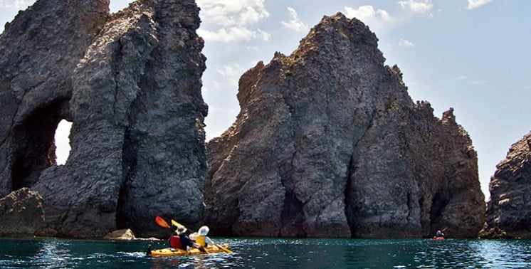
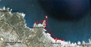
 Route No. 1 covers a distance of 6.6 km and lasts 2.5-3 hours. We set off from Gerania beach and paddle close to the shore, exploring more than 10 caves known for their magnificent colours. Just before our break, almost in the middle of the route, we come across the shipwreck of a merchant ship and a secret surprise cave! The break takes place at Sarakiniko beach and lasts 15-25 minutes. Anyone who wishes can continue hiking with the group leader to see the caves and the rock formations in the area, or explore the seabed by diving! After some rest, we set off on the way back, paddling faster to get a more intense workout this time. Finally, we arrive at a local snack bar in the Mandrakia area for a quick ouzo shot!
Price: 35 euros
The kayak Sarakiniko route runs along the north coast, from Gerania beach to the fishing harbour of Mandrakia, and a sea kayak is the calmest way to meet that shore. The Milos island pages set out the island bay by bay, with its beaches, villages and rock. The line follows that same shore for 6.6 km, past caves, a wreck and white stone.
Wind decides the day on this shore. The north side of Milos takes the full brunt of the summer northerly, so a paddler starts early and stays close to the rock. The reward is a coastline of volcanic layers, sea caves, a stranded hull and the pale, bare stone of Sarakiniko, all reached from the water rather than the road.
What does the kayak Sarakiniko route include from Gerania beach to Mandrakia?
The kayak Sarakiniko route starts at Gerania beach, follows the caves of the north shore, passes the wreck of a merchant ship and stops at Sarakiniko. The paddle back ends in the Mandrakia area, and the full line covers 6.6 km.
Route 1 of the Milos sea kayak routes holds a single line along the north coast, and the kayak Sarakiniko route is its central and exposed part. The start is Gerania beach, where the group launches and follows the line of the coast. From there the coast curves past low cliffs, small beaches and a run of caves that the swell has cut into the volcanic rock. The distance of the full line is 6.6 km.
Halfway along, the shore changes character. The soft volcanic tuff has been hollowed into caves, and above them stand the stacked layers of ash, pumice and sandstone that build the whole north side. Just before the break, the kayak Sarakiniko route passes a stranded merchant ship, its hull resting on rocky ground on the eastern, empty side of Sarakiniko. Paddlers see it when the waves pull back from the shore. The rock close to the water is pale and worn smooth by constant movement.
The break falls at Sarakiniko, where the white rock meets deep blue water. The beach itself is a strip of sand only 10 metres long and is not organised, so the boats wait offshore or on the short sand while the group rests. A paddler who wants to stretch can walk up among the stone formations, and one who prefers the sea can slip into the water and look at the seabed below. The kayak Sarakiniko break is the midpoint of the day.
The return is the harder half. With the wind rising through the day, the group paddles back the way it came and puts more power into each stroke, turning the homeward run into training. The shoreline is already familiar, so the boats can hold a steady line past the caves and the wreck. The kayak Sarakiniko route finishes in the Mandrakia area, in a working harbour rather than on an open beach, and the boats come up onto the small beach there.
- Start: Gerania beach is the launch point on the north coast, close to the water line.
- Distance: The full line covers 6.6 km of shore from the first stroke to the last.
- Caves: More than ten sea caves open along the route in the soft rock.
- Wreck: A merchant ship lies stranded on the eastern side of Sarakiniko.
- Finish: The kayak Sarakiniko route ends in the Mandrakia area, in a small harbour.
Six and a half kilometres of coast, ten or more caves, one wrecked hull and a stop on white stone: that is the shape of the day. The route stays on the north side from the first stroke to the last, so the wind and the swell set the pace throughout. The kayak Sarakiniko line rewards an early start and a steady, unhurried stroke.

How does the kayak Sarakiniko route begin at Gerania beach and the north coast?
The kayak Sarakiniko route starts at Gerania beach and turns along the north coast, where layer after layer of volcanic material builds the shore. The oldest layer here is the Pachaina formation, at least 70 metres thick, and the Papafragas formation lies above it.
Gerania beach is the first mark of the day, and the boats line up on the water just off the sand before the group sets a course. The shore ahead is not a single cliff but a long stair of stone, each step laid down by a different phase of the island’s volcanic past. A paddler reads this stair from the water, because the layers show in clean bands above the swell line. The kayak Sarakiniko route follows it eastward.
North Milos is a stack of volcanic layers rather than one rock. The lowest and oldest is the Pachaina formation, at least 70 metres thick, and the Papafragas formation sits above it and grows thicker toward the east. Material from the Papafragas and the Sarakiniko formations appears to have settled through wave action. Pumice layers hold the shore as far as Mytakas, a sandy beach nearby. The kayak Sarakiniko route crosses these bands one by one.
Beyond the pumice the coast turns to tuff, dotted with dry shrubs and young cedars, and the small beaches carry saltbush. The settlement of Agios Konstantinos stands in a shallow fjord that gives basic shelter from the weather, and a cross rises from the rock at its southern end. Below the cross, a chapel is cut into the soft stone. About 200 metres past the beach there, a small cape severed by faults holds a colony of gulls.
A footpath of about 4.5 km follows the same coast from Agios Konstantinos to Sarakiniko, running over flat, walkable rock, though it fades in places. Offshore, the Glaronissia islets rise from the sea, built of andesite and crowned with thousands of upright five-sided and six-sided columns. The columns measure 20 to 30 centimetres across the diagonal and were formed by lava that cooled 800,000 to 700,000 years ago. The kayak Sarakiniko route keeps to the shore below these islets.
- Gerania: The launch beach sits on the north coast, at the western start of the line.
- Layers: Pachaina stone lies at the bottom of the stack, with Papafragas above it.
- Agios Konstantinos: A small fjord holds a settlement, a cross and a cut chapel.
- Glaronissia: Uninhabited islets of andesite columns lie off this part of the coast.
- Footpath: A trail of about 4.5 km follows the shore toward Sarakiniko.
The first stretch sets the pattern for the whole paddle. The shore is close, the water is deep blue, and the rock is soft enough for the sea to carve, yet solid enough to stand in tall columns. Interest comes from the layers themselves, from the tuff and the pumice, and from the way the coast changes with each small bay. The kayak Sarakiniko route begins quietly.
Which caves does the kayak Sarakiniko route pass on the north coast?
The kayak Sarakiniko route passes more than ten sea caves, cut by waves into the pale volcanic rock. Colours inside the caves run from grey and white to turquoise, and a hidden surprise cave appears just before the break at Sarakiniko.
A sea cave begins with a weakness in the rock: a fault, a vein, or the seam between two layers of different hardness. Waves drive into the crack and widen it, and the air trapped inside adds pressure as the water retreats. Sand carried by the water grinds the walls smooth. Sea urchins bore into the floor and, generation after generation, take material away. The kayak Sarakiniko route slides past the mouths of these hollows, while others become tunnels or blowholes.
At Sarakiniko the waves have opened caves along the whole shore. The rock here is very pale, almost without vegetation, so the sea in front reads deep blue while the small natural harbour between the stones turns green-blue. Saracen pirates sheltered in these caves, and the beach took its name from them. Bollards for mooring boats are still cut into the rock. Different layers of the island show white, red, yellow and black stone close to the water.
Three caves belong to Papafragas, beside the ruins of the Bronze Age settlement of Phylakopi. One is a deep sea cave where swimmers move through turquoise water between grey and white rock, and the passage leads out to open sea. In Byzantine times the cove served as a base for pirates, and its name comes from the last Frank priest, who kept a boat there. From land the small beach is reached by a steep carving in the rock.
Just before the break, in the middle of the line, a hidden cave surprises the group. It opens where the cliff looks closed, and the boats slip inside one at a time. Light comes off the walls and colours the water, and the pale stone holds a blue-green glow that changes with each stroke. Outside, waves thrown back from the cliff break the surface into white spray. The kayak Sarakiniko route treats that hidden cave as a marker.
- Number: More than ten sea caves open along the north coast of the island.
- Colours: Grey, white and turquoise fill the hollows, with deep blue water outside them.
- Origin: Waves, faults and sea urchins cut the caves into soft volcanic rock.
- Papafragas: Three caves belong to the cove beside the ruins of Phylakopi.
- Surprise: A hidden cave appears just before the Sarakiniko break.
The caves are the reason this shore belongs to a kayak rather than a road. From the water a paddler sees openings that stay invisible from above, and the pale rock throws light back onto the sea. The colours shift as the boats move, grey and white at one mouth and turquoise at the next. The kayak Sarakiniko route moves from one dark opening to the following one.
What is the shipwreck that the kayak Sarakiniko route passes?
The kayak Sarakiniko route passes the wreck of a merchant ship that struck Sarakiniko in 2003. The hull rests on rocky ground on the eastern, empty side of the area, and it shows when the waves draw back from the shore.
A ship goes aground when heavy weather pushes it onto a beach, a reef or a ledge of rock, and the accident carries that name. Wrecks in shallow water are a real danger to navigation, because the sea hides them from passing boats. Where the water is shallow the hull rises and falls with every swell, and steel or iron can keep its shape for decades before the structure gives way. The kayak Sarakiniko wreck sits in that shallow band.
The stranded hull near Sarakiniko lies on the eastern side of the area, where the ground turns dry and stony and the plants are low and grey. The ship struck the coast in 2003 and was left on the rocky shore rather than under deep water. Its outline shows best when the sea pulls away, and then it disappears again as the next swell covers it. Paddlers on the kayak Sarakiniko route watch for that gap.
Greek law has treated a vessel as a wreck since 1945, and the first definition covered ships that had gone wholly or partly under the sea. The wording later grew to include ships that ran onto a coast without sinking, which is the case of the hull beside Sarakiniko. Finds of abandoned ships or cargo have to be reported to the port authority of the area by the finder. Wrecks inside Greek waters pass to the state in the end.
Milos sits roughly midway between Piraeus and Crete, and its large natural harbour divides the island into two almost equal parts, which gave the place weight in shipping. In the nineteenth century it was a meeting point for foreign ships hunting pirates in the Mediterranean. The seabed around the island holds wrecks from the Second World War and from older periods, and they thicken where traffic is heavy. Deeper wrecks last longer, with less moving water and less oxygen. The kayak Sarakiniko route meets only the shallow one.
- Ship: A merchant vessel struck the north coast at Sarakiniko and stayed there.
- Year: The accident happened in 2003, and the hull was left on the shore.
- Place: The wreck lies on the eastern, dry side of the Sarakiniko area.
- Visibility: The outline shows when the waves pull back and hides when they return.
- Depth: Shallow water leaves the hull open to every swell of the sea.
A wreck on a shallow shore is never still. The sea lifts it, drops it and grinds the edges, so the outline changes from season to season. From a kayak the shape reads clearly against the pale rock, low and broken and part of the coast now. The kayak Sarakiniko route passes it in silence, and the group keeps a respectful distance from the hull.
What does the kayak Sarakiniko route offer at Sarakiniko from the water?
The kayak Sarakiniko route breaks at Sarakiniko, a shore of white volcanic rock with almost no vegetation. A paddler can walk up among the stone formations with a tour leader or slip into the water and dive over the seabed instead.
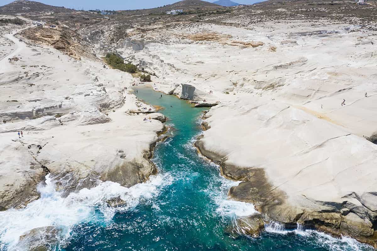
The white stone of Sarakiniko was deposited in repeated layers that began to settle about 1.85 million years ago, when the material lay under the sea. Rise brought it to the surface, and wind and waves then smoothed the softer parts and left the harder bands standing. The formation is roughly 50 metres thick and holds sandstone with pumice breccia and siltstone rich in fossils. From a kayak the whole face reads as one pale wall above deep blue water, one shore among the beaches of Milos.
The western side of Sarakiniko is bare white rock, and the shapes there are compared to a lunar landscape. The eastern side is dry ground with sparse plants and stone, and that difference shows from the water as the boats come in. Visitors once carved their names into the stone, and the municipality set a fine in 2015 for polluting the area. The rock is soft, so every mark lasts. The kayak Sarakiniko route approaches the quieter face first.
The break gives the group a chance to leave the boats. One choice is to walk up among the formations with the tour leader and look at the caves and the strange stone shapes from above. The other is to stay in the sea and dive, exploring the seabed where the pale rock continues under the water. The sand strip at the head of the bay is only 10 metres long and there are no facilities, so the stop stays simple.
The stones around Sarakiniko carry the remains of sea life: bivalves, scaphopods, gastropods, brachiopods, echinoids and barnacles. Tiny diatom fossils in the layers date to between 1.95 and 1.73 million years ago, at the start of the Pleistocene. Between the white formations a small bay opens, and the water inside its natural harbour turns green-blue. A little sand lies at the head of the bay, with shallow water and small patches of shade behind. The kayak Sarakiniko break sits in this pocket of calm.
- Rock: White volcanic layers stand above deep blue water at Sarakiniko.
- Walk: A tour leader takes a short walk among the stone formations.
- Dive: A paddler can swim instead and look over the seabed below.
- Sand: The beach is a strip of 10 metres and carries no facilities.
- Fossils: Shells and diatoms lie inside the layers of pale stone.
Sarakiniko is the turning point of the day, the place where the group rests before the harder half. The white stone, the dark blue water and the small green bay give the stop its character. A walk over the rock or a dive under it fills the pause, and then the boats are pushed off again. For much of the kayak Sarakiniko route this is the memory that stays.

How does the kayak Sarakiniko route end in the Mandrakia area?
The kayak Sarakiniko route returns along the same north coast, paddled harder for training, and finishes in the Mandrakia area. Mandrakia is a fishing village about 4 km north of Adamantas, with a small harbour that gives the boats shelter.
The way back follows the same line of rock, this time with the group pulling harder to make the homeward run a training session. Strokes grow longer, the boats sit closer together, and the shoreline passes in reverse: the hidden cave, the caves in the pale stone, the wreck on the shallow shelf. Wind builds through the day in the meltemi season, so the return can feel twice as long as the outward leg. The kayak Sarakiniko route ends where the water quiets down.
Mandrakia is a fishing village on the north coast, about 4 km north of Adamantas, the port of the island, and about 9 km east-north-east of Plaka, the seat of the municipality. It was listed as a separate settlement in 1961 and had 13 residents in 2021. Above the harbour stands the church of Zoodochos Pigi, which shows clearly from the sea. The houses and the boat shelters line the water, and the whole place holds its working character. The kayak Sarakiniko route finishes in a living harbour.
The best-known feature of Mandrakia is the row of sirmata, the boat shelters dug into the volcanic tuff along the shore. The name comes from fishermen dragging their boats from the shelter down to the water. Inside, boats stayed out of the weather through the winter, and today the same spaces hold fishing gear and serve as simple rooms in summer. From the water the kayak Sarakiniko route passes them one by one before the boats come ashore.
In front of the houses lies a quiet beach almost 150 metres long, with fine dark grey pebbles and tamarisk trees along the edge. The dark pebble stands against the white stone of Sarakiniko further back along the route. Kayaks come in on the sand and the paddles are raised for the landing. The village keeps a small beach that suits a quiet finish after the wind and the open water. The kayak Sarakiniko route closes here.
- Return: The group paddles back along the same line of shore.
- Pace: The homeward leg is worked harder than the outward one.
- Village: Mandrakia is a fishing place with a small working harbour.
- Sirmata: Boat shelters are cut into the volcanic tuff of the coast.
- Beach: Fine dark grey pebbles edge a quiet bay of almost 150 metres.
The finish gives the day its contrast. The route begins on open shore and ends between houses and boats, in a place that still works for fishing. The dark pebbles, the church above the water and the cut shelters mark the last metres of the paddle. The kayak Sarakiniko route ends in a harbour rather than on an empty beach.

What do paddlers ask about the kayak Sarakiniko route?
The kayak Sarakiniko route raises questions about distance, caves, the wreck, the break and finish. Answers sit in the line itself: 6.6 km of north coast, more than ten caves, a merchant ship on the shore, a stop at Sarakiniko and an end in the Mandrakia area.
Where does the kayak Sarakiniko route start and finish?
The launch is at Gerania beach on the north coast, and the finish is in the Mandrakia area, a fishing harbour about 4 km north of Adamantas. The line stays on the north side of Milos throughout, past sea caves and the white stone of Sarakiniko. The return leg carries the group back along the same shore to the harbour.
What distance does the kayak Sarakiniko route cover?
The line from Gerania beach to the Mandrakia area covers 6.6 km, and that figure takes in the outward leg, the break at Sarakiniko and the paddle home. The kayak Sarakiniko route stays on the north coast throughout, so the whole distance falls along one continuous shore. The ground is covered twice, once out and once back.
What number of caves does the kayak Sarakiniko route pass?
More than ten sea caves open along the north coast on this line. The kayak Sarakiniko route meets caves cut by waves into soft volcanic rock, and their walls carry grey, white and turquoise tones. Papafragas adds three caves of its own beside the old settlement of Phylakopi, and a hidden cave appears just before the break at Sarakiniko.
Which shipwreck does the kayak Sarakiniko route pass near Sarakiniko?
A merchant ship struck the coast at Sarakiniko in 2003 and stayed there. The kayak Sarakiniko route passes the hull on the eastern, dry side of the area, where the ground is rocky and the plants are low. The wreck shows when the waves pull back from the shore and hides again under the next swell.
Where does the kayak Sarakiniko route stop for a break?
The break falls at Sarakiniko beach, where the white rock meets deep blue water. The kayak Sarakiniko route pauses there while the group rests on the short strip of sand or stays in the boats offshore. The beach is 10 metres long and carries no facilities, so the stop is a simple one between two long stretches of paddling.
What can a paddler do at the break on the kayak Sarakiniko route?
Two choices wait at the break. A paddler can walk up among the stone formations with the tour leader and look at the caves and rock shapes from above, or stay in the water and dive over the seabed below. The kayak Sarakiniko route gives time for either before the boats turn for home.
When is the north coast calm for the kayak Sarakiniko route?
The north coast faces the summer northerly, and that wind builds through the afternoon and drops at night. The kayak Sarakiniko route runs in the months before and after high summer, when the strong northerly is absent for longer spells, and it starts early in the day. Organised day trips on this coast take place from April to October.
Which colours appear along the kayak Sarakiniko route?
The rocks of Milos come in white, red, yellow and black, and the kayak Sarakiniko route shows four of those tones from the water. The stone at Sarakiniko is pale and bare, with deep blue water in front of it and green-blue water in the small natural harbour. Turquoise fills the cave at Papafragas.