Route No. 05 (Tria Pigadia – Theiorichia) covers a distance of 8.8 km and lasts about 4-5 hours.
Price: 40 euros. Transport, equipment, food and safety are included.
Tweet
Milos is the southwestern island of the Cyclades, set roughly midway between Piraeus and Crete. Volcanic activity gave the land its white, red, yellow and black rocks, and the sea carved the caves and coves along the shore. Travellers planning days on the water begin with the Milos travel pages, which collect the coasts, villages and history of the island in one place.
The east side of the island carries a chain of small beaches, from Voudia and Kastanas down to Paliorema and Thiorichia. Water along this shore stays clear, and pebbles cover the landings instead of sand. One route links Tria Pigadia with the old sulphur workings, and that route is the subject of the pages that follow here.
What does the kayak Thiorichia route cover?
The kayak Thiorichia route runs 8.8 km from Tria Pigadia to the abandoned sulphur mines on the east coast of Milos. Transport, equipment, food and safety provision are included in the outing, which finishes at the old workings and their small cove.
The paddler sets out from Tria Pigadia, a small, rocky and remote beach on the east side of the island, placed between Kastanas and Agali. Pebbles form the landing and a wall of pale rock rises behind it. Open water lies ahead, with the land climbing on one side and the Aegean running away on the other. The kayak Thiorichia route bends south from here, and the old workings of Paliorema wait at the far end of the crossing.
The distance between the two points is 8.8 km, measured along the shore. That figure sets the shape of the day on the water. The paddler moves south along an exposed coast where the land drops straight into the sea and the next landing is never close. Wind direction decides how much work the crossing demands, and the kayak routes around Milos follow the same shoreline logic, hugging the rock and turning into each cove as it appears.
The kayak Thiorichia route carries its own support. Transport to the water, equipment for the paddle, food and safety provision are part of the arrangement, so the paddler does not haul a heavy load across the island. A light boat handles better on a long open stretch, and the absence of camping gear keeps the cockpit clear through the crossing. Nothing is left to chance, and the group arrives at the water ready to launch.
The finish is the small cove at Paliorema, where the old sulphur works stand above yellow pebbles and clear water. Wagons rest on rails, tools lie where the work stopped, and spare parts fill a warehouse. A paddler who lands here steps from open sea into an industrial yard that has stood unused since the middle of the twentieth century. The kayak Thiorichia crossing ends beside those quiet rails and the empty buildings above the water.
- Start: Tria Pigadia, a small rocky beach on the east side, where the kayak Thiorichia route begins.
- Finish: the cove of Paliorema, below the abandoned sulphur workings.
- Distance: 8.8 km of open coastline along the east side of the island.
- Included: transport, equipment, food and safety provision.
- Shore: pebbles, pale rock walls and clear water with no sand.
The kayak Thiorichia route packs a whole picture of the east coast into a single crossing. It starts at a quiet pebble beach, follows a wall of pale volcanic rock, and ends among the ruins of an industry that once shipped sulphur from this shore. The paddler meets the island twice over: first as a wilderness of stone and water, then as a place of work that stopped.

Why does the kayak Thiorichia route start at Tria Pigadia?
The kayak Thiorichia route begins at Tria Pigadia, a small, rocky and remote beach on the east side of Milos, set between Kastanas and Agali. The landing takes pebbles rather than sand, and pale rock rises straight behind it, giving shelter to the boats before the crossing.
Tria Pigadia sits on the east side of Milos, in the line of beaches that runs from Voudia in the north to Thiorichia in the south. Kastanas lies on one side of it and Agali on the other. The shore is small and remote, the ground behind the water is stone rather than soil, and no buildings break the line of the coast. The kayak Thiorichia route starts from this quiet strip of pale pebbles.
The name belongs to a landscape of wells and rock. Above the water, the slope carries the grey and ochre tones of old volcanic material, and the beach itself is a strip of pebbles that shifts with winter weather. A paddler stands on a shore that is rocky and remote, and the road ends well before the water. There is no harbour here, only open sea and the long line of the coast to the south.
Launching here means committing to open water. The coast runs south without interruption, and the land behind the beach rises steeply enough to block an easy walk out. Kayaks wait on the pebbles, paddles are checked, and the group turns its back on the road. The first strokes carry the boats away from the shelter of the bay into the channel, where the kayak Thiorichia route begins in earnest. The water deepens quickly beyond the stones.
The east side of Milos is a place of small landings and long gaps. Between Tria Pigadia and the old mines lie Kolympisionas, Agali, Rema and Paliorema, each a narrow strip of pebbles at the foot of a slope. From the water these coves appear one after another, separated by cliffs that drop into clear water. A paddler counts them off along the way, and each one marks another stage of the kayak Thiorichia route.
- Position: the east side of Milos, between the beaches of Kastanas and Agali.
- Surface: pebbles and rock, with no sand along the landing.
- Setting: a remote shore with steep ground behind it.
- Water: clear, with a long open stretch to the south.
- Role: the starting point of the kayak Thiorichia route.
Tria Pigadia gives the crossing its first character. The beach is quiet, the landing is rough, and the land behind it climbs away from the sea. A paddler who launches here leaves the road and the villages behind in a single stroke, and turns a small pebble shore into the doorway of a long coastal run, with the kayak Thiorichia route stretching ahead.
What does the coast look like on the kayak Thiorichia crossing?
The kayak Thiorichia crossing follows a coast of pale volcanic rock, pebble coves and clear water, with the land rising straight from the sea. Cliffs, narrow beaches and coloured stones mark the way south, and the water stays transparent over a rocky bottom for the whole run.
From the water, the east coast reads as a single wall of stone broken by narrow openings. The rock shows grey, ochre and rust tones, with darker bands where volcanic material cooled in place. The island is built of tuff, trachyte and obsidian, and the shoreline carries those materials to the sea in cliffs and loose slopes that fall straight into clear water. The kayak Thiorichia route follows that long wall of stone for its whole length.
Volcanic activity on Milos began two to three million years ago and stopped 90,000 years ago, and the island still counts as a dormant volcano. That history shows along the coast. The eastern shore of the harbour carries hot sulfurous springs, and the heat of the volcano remains strong in one of the caves on the south coast, so water and rock keep a connection that a paddler senses in the air, where the smell of sulphur hangs over the stones.
Pebble coves interrupt the cliffs at intervals. Kastanas has no sand, only small stones in red, orange and purple shades, and the rocks around it carry the same colours. Kolympisionas and Rema hold deep blue water over coloured pebbles, and the shades of the surrounding rock give each landing its own tone. From a kayak, those bands of colour appear long before the beach itself, and the kayak Thiorichia route passes each of them in order.
The water along this shore stays clear enough to show the bottom. Light passes through and picks out the stones, so the sea reads as a window rather than a surface. A paddler sees the shadow of the boat travel across the seabed, watches the rock slide past below the hull, and measures progress by the changes in colour rather than by the land. The kayak Thiorichia route runs over that open window for its full length.
- Rock: pale volcanic stone in grey, ochre and rust tones.
- Coves: narrow pebble landings such as Kastanas, Kolympisionas and Rema.
- Water: clear and deep blue over a visible rocky bottom.
- Colour: stones in red, orange and purple shades.
- Sea life: the volcanic seafloor makes this a rich fishing ground.
The crossing rewards attention to detail. Cliffs give way to pebble bays, colours change from grey to rust to purple, and the bottom stays visible under the boat. The kayak Thiorichia route passes no harbour and no village, so the coast keeps a wild and open character from the first stroke to the last, with the sea doing the talking.
What can a paddler see at the kayak Thiorichia finish?
At the kayak Thiorichia finish the cove of Paliorema holds yellow pebbles and clear water beneath the ruins of the old sulphur works. Wagons stand on their rails, rusty tools lie in place, and unused spare parts fill a warehouse that served the mine until 1956.
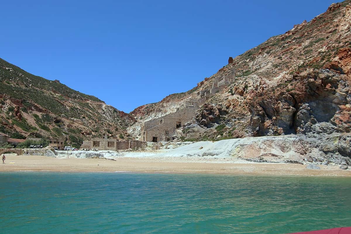
The cove opens on the east coast at Paliorema, below the workings that gave Thiorichia its name. Yellow pebbles line the water and the sea stays clear over the stones. The beach counts among the geological attractions of the island, because the ruins of the old mine sit directly above the shore and the slope behind them carries the marks of extraction. The kayak Thiorichia route ends at this quiet point of the east coast.
The buildings of the mine survive as a set of structures at the head of the beach. A warehouse holds unused spare parts, and rusty tools rest where they were left. Wagons stand on rails that once carried material to the water for loading. The yard is quiet, the metal is corroded, and the arrangement of the site still shows how the work was organised. Everything sits close to the water’s edge, within sight of the boats below.
Sulphur from this shore left the island by sea, and the small cove served as the loading point. The mine ran its sulphur exports until 1956, and when the work stopped the settlement lost its reason to exist. The place now appears in official lists with no residents at all, so the houses, the rails and the warehouse stand as an empty village beside the water. Nobody lives among these walls today, and the empty village keeps its silence.
The atmosphere of the cove comes from that contrast. Clear water and coloured stones lie on one side, and corroded industry lies on the other. A paddler who steps ashore walks between the two in a handful of steps, moving from the sound of the sea into a yard of rails, tools and stone walls that the island has left exactly where the last shift ended. The kayak Thiorichia route closes on that quiet note.
- Cove: Paliorema, the finish of the kayak Thiorichia route, with yellow pebbles.
- Buildings: a warehouse, walls and a yard above the beach.
- Equipment: wagons on rails and rusty tools left in place.
- Export: sulphur loaded onto boats from the small bay.
- Status: an abandoned settlement with no permanent residents.
The kayak Thiorichia route ends where the industrial past of the island meets its coast. Rails run towards the water, a warehouse keeps its spare parts, and the beach below is covered in yellow pebbles. A paddler arriving from the open sea lands in a working yard turned museum without walls, and the silence of the place carries its own weight.
Why did sulphur mining on the kayak Thiorichia coast end?
Sulphur mining on the kayak Thiorichia coast ended in the middle of the twentieth century, when the works at Paliorema stopped exporting. Milos had held the richest supply of sulfur in the ancient world, and other minerals of the island took over as the main source of income.
Milos is a volcanic island, and its rocks have drawn people for thousands of years. Obsidian from the island travelled across the Aegean and the Mediterranean from the Neolithic age, cut into tools before farming spread through the region. In later periods the island supplied minerals of other kinds, and during Roman rule its development continued through the steady exploitation of that mineral wealth, as the history of Milos shows. The kayak Thiorichia coast carries the later part of that long story.
Sulphur belongs to the volcanic character of the place. Springs and vents on the island release gases from deep below, and sulphur appears in the areas around them. The eastern shore of the harbour carries hot sulfurous springs, and fumaroles on the island reach temperatures close to the boiling point of water. Milos held the richest supply of sulfur in the ancient world, and the mineral was worked here for a very long period of time.
Modern extraction began on the east coast, at the workings above the cove of Paliorema. Sulphur left the island by boat, and a small settlement grew beside the mine to house the people who worked it. Wagons carried material to the water, a warehouse stored spare parts and supplies, and the yard above the beach held the tools of the trade. The mine shipped its sulphur until 1956. The kayak Thiorichia route reaches that working yard from the sea, arriving where the boats once loaded.
The end came with the middle of the twentieth century. Sulphur mining on Milos stopped, and the settlement at Thiorichia emptied until official lists showed no residents there at all. The working minerals of the island changed as well: bentonite, perlite, pozzolana and kaolin are collected today in open pits and sold around the world, while baryte, sulfur, millstones and gypsum belong to the past. The kayak Thiorichia route carries a paddler past the last chapter of the sulphur years.
- Ancient supply: Milos held the richest supply of sulfur in the ancient world.
- Working life: sulphur exports from the cove until 1956.
- End: the mine closed and the settlement emptied.
- Today: bentonite, perlite, pozzolana and kaolin are mined instead.
- Legacy: a collection of minerals keeps the mining story alive on the island.
The story of sulphur on Milos runs from the ancient world to the middle of the twentieth century and then stops. What remains is a set of buildings on a beach, a rail line to the water, and a mineral museum that keeps the wider mining history of the island. The kayak Thiorichia route carries a paddler through the final chapter of that story.

How does weather shape a kayak Thiorichia day on the water?
Wind shapes the kayak Thiorichia day more than any other factor, because the crossing runs along an open coast with no shelter. Meltemia and north winds raise the sea, while the warm dry summer months give the calmest conditions and the clearest water for the long paddle south.
Milos has a Mediterranean climate with mild, rainy winters and warm to hot dry summers. August brings mean daily highs of about 28 degrees Celsius, and January sits near 13 degrees. Rain falls mainly between October and March, and the summer months pass with very little of it. For a paddler, that pattern points to the warm half of the year as the natural season for the kayak Thiorichia crossing, and the sea stays calm through long stretches of it.
Wind is the decisive factor on this coast. Meltemia and north winds blow across the Aegean and raise the sea on exposed shores, and the advice offered to swimmers on the island is to choose a bay or a southern shore when they arrive. The east coast lies open to the weather, so a paddler watches the forecast, reads the whitecaps, and judges the crossing against the strength of the breeze. A change of direction changes the whole day.
The sea itself stays clear and inviting. Water along the east side passes over pebbles and rock, and the bottom remains visible from the boat. Sheltered coves offer calm water at intervals, and the deep blue tone reported at Kolympisionas and Rema shows how clean the sea is here. The volcanic ground below also makes this coast a rich fishing area. A paddler reads the surface for signs of the reef beneath, because shallow ground and open water meet along this shoreline.
Equipment, food and safety provision come with the route, so a paddler travels light and carries little beyond personal items. Transport to the start removes the need for a long approach on foot. Everything needed for the water waits at the launch, and the boat, the paddle and the safety gear are ready before the group leaves the pebbles of Tria Pigadia. The kayak Thiorichia route keeps the load small, so attention stays on the water and on the line of the coast ahead.
- Season: the warm, dry summer months, when rain is rare.
- Wind: meltemia and north winds raise the sea on open coasts.
- Shelter: bays and the southern side of the island on windy days.
- Sea: clear water over pebbles and rock on the kayak Thiorichia coast.
- Kit: equipment, food and safety provision come with the kayak Thiorichia route.
A paddler on this coast works with the weather rather than against it. The season sets the temperature, the wind sets the difficulty, and the clear water sets the reward. Conditions on the east side change with the direction of the breeze, so the decision to launch rests on a careful reading of the sea, and the kayak Thiorichia crossing goes ahead when the day suits it.

What is worth knowing before the kayak Thiorichia route?
The kayak Thiorichia route covers 8.8 km from Tria Pigadia to the abandoned sulphur mines, and transport, equipment, food and safety provision come with it. The coast is open, the landings are pebbles, and the finish sits among the ruins of the old mine at Paliorema.
Where does the kayak Thiorichia route begin and end?
It begins at Tria Pigadia, a small, rocky and remote beach on the east side of Milos, placed between Kastanas and Agali. It ends at the cove of Paliorema, below the abandoned sulphur mines. The two points sit on the same stretch of coast, so the route runs in one direction along the shoreline without turning back at any stage.
What distance does the kayak Thiorichia route cover?
The route covers 8.8 km of coastline between Tria Pigadia and the old mines. The figure is measured along the shore, and it sets the length of the day on the water. Wind and sea conditions decide how much effort the crossing asks for, because the coast offers no harbour and only narrow pebble landings between the two ends.
What is included with the kayak Thiorichia route?
Transport, equipment, food and safety provision are part of the arrangement. A paddler therefore brings personal items rather than a full kit, since the boat, the paddle and the safety gear travel with the group. Transport also removes the need to walk to the launch point, which matters on a coast where the road ends short of the water.
What remains at the kayak Thiorichia finish today?
The cove of Paliorema holds yellow pebbles, clear water and the ruins of the old sulphur works. Wagons stand on their rails, rusty tools lie in place, and unused spare parts fill a warehouse. The settlement appears in official lists with no residents, so the buildings and the yard stand empty above the beach.
Which conditions suit the kayak Thiorichia crossing?
Warm, dry summer weather suits the crossing best, because rain is rare and the sea stays calm for long stretches. Meltemia and north winds raise the water on exposed coasts, and the advice given to swimmers on the island is to seek a bay or a southern shore when those winds arrive. A paddler reads the forecast first.
What makes the kayak Thiorichia coast worth the paddle?
The coast offers clear water, coloured pebbles and cliffs of pale volcanic rock, all seen from a boat rather than a road. The finish adds a second layer: an abandoned mine, a warehouse of spare parts and a rail line that once carried sulphur to the sea. Nature and industry meet within a handful of steps.